►
Description
No description was provided for this meeting.
If this is YOUR meeting, an easy way to fix this is to add a description to your video, wherever mtngs.io found it (probably YouTube).
A
Hello
and
thank
you
for
taking
the
time
to
learn
more
about
the
Gateway
area
plan
proposal
for
balancing
Transportation
modes,
with
an
emphasis
on
bike
and
pet
safety,
as
well
as
what
is
proposed
for
new
and
enhanced
bike
and
multi-use
Trail
facilities,
I'm
David
Loya,
the
director
of
Community
Development
for
the
city
of
Arcata
and
I'm
pleased
to
share
this
information
with
you
today.
Please
feel
free
to
reach
out
to
me
or
my
team.
If
you
have
any
follow-up
questions
and
as
always,
let
the
city,
council
and
Planning
Commission
know
your
thoughts
as
well.
A
But
if
you
need
a
refresher
on
what
the
Gateway
area
plan
is
the
boundaries
or
why
the
undertaking
is
happening
in
the
first
place,
please
visit
our
YouTube
channel
with
the
search
term
gateway
to
learn
more
about
these
topics.
You
can
also
learn
more
on
our
website
by
searching
Arcata
and
Gateway
I'm
going
to
start
by
reviewing
the
purpose.
As
stated
in
the
plan,
the
purpose
was
developed
through
Community
feedback,
as
well
as
current
best
practices
for
trail
and
transportation
planning.
A
We
also
use
modern
Transportation
Planning
principles
that
emphasize
reducing
vehicle
miles,
traveled
and
making
modes
of
travel,
whether
on
foot
or
by
wheel,
feels
safe
and
comfortable
on
New,
Roads
and
trails.
We're
planning
the
city
is
growing.
We
need
to
plan
for
that
growth
to
make
sure
the
infrastructure
can
continue
to
support
and
to
enhance
the
high
quality
of
life
our
Cadence
have
come
to
enjoy.
A
Specifically,
we
want
to
plan
to
continue
to
support
a
robust
network
of
bicycle
pedestrian
and
Transit.
That's
balanced
with
vehicular
infrastructure
to
ensure
that
folks,
using
all
modes
feel
safe.
The
plan
seeks
to
improve
the
current
condition
for
people
using
the
sidewalks
bike
lanes
and
multi-use
trails.
A
I
want
to
take
a
moment
to
address
a
misconception
about
the
proposal
here
and
to
emphasize
that
the
multi-use
trails,
including
the
Bay
Trail
North,
which
is
part
of
the
California
Coastal
Trail
and
which
is
planned
to
extend
to
the
Annie
and
Mary
Trail,
will
remain
intact
and
in
place.
The
plan
does
call
for
a
minor
realignment
of
the
northern
section
of
the
L
Street
segment
of
this
Trail
to
improve
user
safety
and
enjoyment.
We'll
take
a
closer
look
at
that
in
a
moment.
A
A
The
policy
and
strategy
are
generally
depicted
in
figures.
Eight
and
nine
of
the
plan
figure
eight
shows
the
planned
vehicular
circulation
Network,
emphasizing
the
proposed
changes
and
figure
nine
on
the
right
shows
the
existing
and
planned
alternative
modes
of
transportation,
including
bike
and
bed
trails.
A
This
image
depicts
the
Gateway
area
and
surrounding
areas
slightly
grayed
out
with
the
existing
facilities,
multi-use
path
class,
two
three
and
class
two
and
three
bike
routes
and
bike
Lanes
depicted
in
the
solid
lines.
You'll
note.
In
the
center
of
the
field,
a
view
is
L
street.
The
L
Street
Corridor
is
our
current
existing
multi-use
path.
That's
a
class
one
Trail.
A
The
proposed
facilities
are
shown
in
dashed
lines
in
these
figures.
I
want
to
draw
your
attention
to
the
number
of
new
class
ones.
Separated
multi-use
trails
that
are
proposed,
notably
in
as
in
Nancy
Street,
which
connects
to
the
west
side
of
Creamery
district
is
proposed
to
be
extended
from
Alliance
near
Shea
Park
to
Samoa,
along
or
near
the
existing
rail
Corridor.
The
precise
location
of
these
Trails
will
be
determined
in
pre-development
planning.
A
Other
multi-use
Trail
locations
include
along
Q
Street
and
the
connection
of
L
and
N
streets
with
the
End
Street
Trail,
the
northern
section
of
L
Street
multi-use
Trail
may
need
to
be
relocated
to
continue
to
provide
the
same,
separated,
Trail
experience
in
the
future.
If
the
L
street
is
extended,
this
relocation
is
proposed
to
start
near
the
10th
and
L
Street
intersection,
where
the
trail
currently
jogs
to
the
east
of
the
rail
onto
L
street.
A
The
trail
would
be
relocated
to
the
west
side
of
the
tracks
or
on
top
of
the
tracks,
to
provide
a
larger
buffer
from
the
traffic
on
L
Street.
If
L
Street
returned
into
a
one-way
southbound
coupling,
this
is
important
for
the
public
to
understand.
Some
have
been
confused
that
the
proposal
eliminates
the
multi-use
trail
along
L
Street.
In
fact,
the
trail
will
be
improved
and
the
overall
system
will
be
greatly
expanded
by
the
proposed
plan.
The
plan
emphasizes
a
walkable,
bikeable
and
high
quality
of
life
vision
for
the
Gateway
area.
A
Now
that
we've
looked
at
the
trail
system
and
understand
that
no
trails
are
being
eliminated
and
that
the
plan
proposes
the
addition
of
several
new
trails
and
bike
Lanes.
Let's
take
a
look
at
the
proposed
Road
systems.
The
road
systems
are
going
to
have
to
adjust
from
their
current
configurations,
to
accommodate
these
new
trails
and
to
create
the
types
of
improvements
in
safety
that
we're
seeking.
A
These
roads
will
enhance,
walking
and
biking
experience
and
reduce
the
drive
Lanes
considerably
emphasizing
these
alternative
modes.
There
are
several
diagrams
in
the
Gateway
area
plan
that
you
can
view
on
our
website
to
see
what's
proposed
for
8th
and
9th
Street,
but
I
really
want
to
emphasize
and
focus
on
the
k.
L,
One,
Way
couplet
that's
being
proposed
because
it's
been
the
focus
of
community
dialogue.
Today,
let's
start
by
looking
at
the
existing
conditions
on
K
Street.
Currently
K
Street
works
well
enough
for
vehicular
traffic.
A
A
The
idea
being
that
folks
will
use
other
modes
of
transportation
if
vehicular
traffic
isn't
working
for
them.
You'll
note,
however,
that
the
infrastructure
for
bikes
is
not
as
good
as
it
could
be
in
this
image.
Currently,
the
bike
lane
is
shared
with
the
travel
lanes
for
vehicles,
that
is,
there
is
no
designated
bike.
Lane
we've
painted
shares
to
remind
drivers
that
the
lanes
are
intended
for
bikes
as
well
as
cars,
but
this
does
not
create
a
comfortable
biking
experience
or
even
the
most
experienced
Riders
compared
with
separated
bike
Lanes
for
pedestrians.
A
The
situation
is
acceptable,
but
it
could
be
better.
There
are
five-foot
sidewalks
on
either
side
of
K
Street
and
the
crosswalks
are
well
marked.
However,
the
crossing
this
street
requires
approximately
a
40-foot
path
of
travel
across
two
ways
of
travel
lanes
and
two
rows
of
parking,
so
there
could
be
improvements
here
again.
One
of
our
main
objectives
in
updating
the
mobility
network
is
in
to
enhance
the
walkability
and
bikeability,
while
improving
the
connectivity
between
downtown
and
the
Gateway
area.
A
A
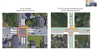
Here
you
see
the
current
on
the
left
and
proposed
Crossings
for
K
and
9th
Street.
The
number
of
conflicts
is
greatly
reduced
here
by
reducing
traffic
Transit
from
two
lanes,
both
ways
to
one
wet
Lane,
both
ways
again.
This
is
a
very
well
designed
set
of
one-way
couplets.
What
are
the
number
of
conflicts
is
greatly
reduced.
There
are
separated
bike
Lanes
on
both
K
and
9th
Street
Crossings
are
reduced
to
a
maximum
of
24
feet
and
the
boldouts
and
crosswalk
design
help
calm
traffic
it
as
it
approaches
these
intersections.
A
A
A
By
creating
one
way
of
travel,
you
reduce
the
travel
Lanes
considerably,
creating
plenty
of
room
for
doubling
the
size
of
the
sidewalks
on
both
sides
of
the
street.
So,
instead
of
five
foot
sidewalks,
we
have
10
foot
sidewalks
plan.
There
is
also
added
room
to
create
a
wide
unidirectional
bike
lane
and
a
buffer.
Now
this
bike
lane
can
be
either
just
separated
by
that
buffer,
or
we
can
enhance
that
separation
further
and
create
a
full
class
four
bike
lane
here
and
this
proposal
does
retain
parking
on
one
side.
A
If
the
plan
View
and
the
visualization
didn't
work
for
you,
looking
at
the
street
view,
here's
another
visual
visualization
of
a
typical
for
K
Street
and
again
you'll
note
that
the
class
4
segregated
bike
lane
is
created
by
elevating
the
bike
lane
to
the
elevation
of
the
sidewalk.
Instead
of
requiring
the
bike
lane
to
be
on
the
same
level
as
the
road
that
creates
that
segregation.
A
Street,
we'll
take
a
look
at
the
Alternatives
in
a
moment,
but
first
I
want
to
review
the
current
condition
of
L
Street
and
what
the
Gateway
proposal
recommended
by
the
Planning
Commission
is
currently
L
street
is
open
between
11th
and
7th
to
local
traffic.
Only
there
are
bollards
preventing
traffic
from
entering
at
11th
Street.
A
A
This
portion
of
the
Bay
Trail
is
as
well
as
the
second
segment
between
10th
and
11th
are
actually
shared
with
the
road.
While
this
is
an
extremely
low
flow,
local
traffic,
only
portion
of
L
Street,
the
trail
is
not
technically
a
class
one
multi-use
Trail
in
this
segment,
since
it's
on
the
road,
the
reason
I
emphasize.
A
Okay,
getting
back
to
L
street
for
a
second
here.
L
Street
also
does
not
extend
south
of
7th
Street,
so
there
are
current
gaps
in
the
flow
of
traffic
from
L
Street,
some
created
by
our
bollards,
others
that
are
just
a
factor
of
not
having
L
Street
ever
been
developed
on
those
segments
or
having
been
abandoned.
A
Let's
take
a
look
at
what's
proposed
in
the
plan.
Again,
you
can
see
from
this
Vantage
that
much
of
the
proposal
for
L
Street
mirrors
the
K
Street
in
many
ways.
There's
one
lane
of
traffic
southbound
this
time,
broad
sidewalks,
fallouts
and
high
visibility.
Crossings,
the
one
notable
difference
is
the
existing
multi-use
Trail
remains
and
it
is
enhanced
by
the
Gateway
proposal.
A
Let's
look
at
the
plan
more
closely.
We're
going
to
zoom
in,
on
this
plan
view
you'll
note
that
this
plan
view
shows
the
orientation
with
North
up.
This
would
put
the
creamery
building
on
the
left
side,
but
let's
look
at
this
as
the
plan
would
be
viewed
southbound.
The
way
vehicular
traffic
would
flow
so
turn
that
all
over
the
call
plan
calls
for
retaining
and
expanding
the
public
sphere
on
the
west
side
of
the
trail.
To
enhance
linear
Park
features
that
currently
exist.
A
Some
properties
have
already
contributed
to
a
park-like
feel
the
creamery
building,
for
example,
is
maintained,
Landscaping
benches
public
art,
all
of
which
have
the
feeling
that
that
landscaped
area,
which
is
actually
on
private
property,
is
part
of
the
public
sphere.
The
plan
calls
for
expanding
and
adding
to
this,
requiring
developers
and
Property
Owners
to
contribute
area
to
this.
The
west
side
of
the
trail
to
create
that
broader
linear
Park
feel
plan
proposals
retaining
the
multi-use
trails
I've
mentioned
earlier,
and
the
vegetative
buffer,
creating
that
separation
from
the
travel
Lane.
A
A
Let's
take
a
look
at
what
that
might
look
like
on
L
Street,
south
of
8..
You
can
see
here
that
there's
really
not
much
change
to
the
existing
physical
conditions,
some
re-striping
repaving
to
touch
up
the
road
and
that
sort
of
thing,
and
while
this
will
become
a
primary
southbound
Road
under
the
commission's
recommended
proposal,
the
road
design
would
emphasize
reducing
travel
speeds
through
several
Road
Design
Elements,
some
of
which
we've
already
discussed
like
narrowing
Lane
Woods,
bull
balance
and
other
environmental
design
elements.
A
A
A
By
looking
at
again,
the
L
Street
typical
Design
This
is
included
in
our
Gateway
area
plan,
showing
the
planting
strip,
starting
from
the
left
to
right
planting
strip
that
would
be
on
the
westbound
west
side
of
the
trail,
separated
vegetative
buffer
drive,
lane
parking
lane,
and
then
the
sidewalk
I
want
to
note
that
we're
talking
about
retaining
a
class
one
Trail,
not
a
class
four
protected,
two-way
Bikeway,
and
so
that
will
remain
a
multi-use
trail.
It
would
not
be
converted
to
a
Bikeway.
A
This
wraps
up
the
discussion
on
the
proposal
and
I
hope
this
helped
explain
the
relationship
between
the
trail,
the
bike
lane
sidewalk
improvements
that
are
designed
to
improve
user
safety
and
comfort.
The
proposed
redesign
for
vehicular
traffic,
as
proposed
in
the
Gateway
area
plan
I,
also
hope
it's
clear
that
the
city
is
not
proposing
to
remove
any
multi-use
trails
and
to
the
contrary.
The
Proposal
is
to
improve
the
trail
Network,
adding
several
multi-use
trails
and
several
bike.
Lanes.
A
Again,
the
purpose
is
to
create
a
safer,
more
balanced
in
terms
of
travel
mode
and
intuitively
connected
downtown
and
Gateway
area.
I'm,
going
to
focus
on
the
k,
l
couplet
exclusively
and
the
Alternatives
there
for
this
discussion
for
alternatives
to
be
effective,
they
would
need
to
accomplish
several
Mutual
goals.
First,
the
alternative
needed
to
meet
the
safety
and
convenience
goals
for
alternative
modes
of
travel.
A
We've
seen
the
intersection
improvements,
Road
width,
Productions,
sidewalk
widths,
increases
and
other
features
that
create
safety
and
convenience
for
bikes
and
pets.
Previously
any
alternative
that
we
evaluated
and
recommended
had
to
retain
these.
Second,
the
alternative
would
need
to
support
the
infrastructure.
This
may
seem
like
it
goes
without
saying,
but
there
are
lots
of
routes
that
have
been
proposed
that
actually
won't
support
the
infrastructure,
ultimately
that
we
need
to
build
out
this
safer
future.
A
A
So
with
these
primary
principles
in
mind
and
with
the
goals
of
Transportation,
alternative
transportation
safety,
the
city's
Consulting
Traffic,
Engineers
and
City
staff
evaluated
several
routes.
These
were
ultimately
vetted
by
the
Planning
Commission
and
the
commission
recommended
The
Ellen
K
Street
couplet
proposed
in
the
Gateway
area
plan.
A
A
A
This
alternative
has
some
of
the
same
cons
of
the
M
Street
southbound.
In
addition,
because
the
distance
and
circuity
the
end
street
is
likely
to
lead
to
cheaters
following
these
unplanned
routes,
creating
those
unintended
consequences
that
we
talked
about
earlier,
we
evaluated
the
possibility
of
routing
southbound
traffic
along
11th
Street
to
Q
Street,
and
then
it
would
exit
onto
Samoa
Boulevard.
A
This
also
has
some
of
the
same
cons
that
were
discussed
before
there
is
a
road
bed
on
Q
Street,
so
it's
possible
and
practical,
but
the
distance
would
lead
to
even
more
cheaters,
in
particular
for
folks
who
are
trying
to
get
to
101
if
they
were
driving
southbound
and
had
to
drive
all
the
way
over
to
Q.
Street
chances
are
good.
They
would
go
through
downtown
instead
to
get
there.
A
Q
and
O
have
similar
features.
Oak
Street
is
a
possible
alternative
that
was
also
similarly
rejected,
because
it's
not
as
supportive
of
those
goals
and
principles
as
hell,
Street
I
do
want
to
take
a
look
at
J
Street,
with
a
little
bit
more
attention.
J
Street
was
considered
an
alternative
early
on
and
it
would
accomplish
many
of
the
goals
and
is
fairly
attractive
option
for
from
a
Mobility
standpoint.
A
A
So
again
we
have
five
foot
sidewalks
on
either
side,
eight
foot
of
parking
on
either
side
and
12
foot
travel
Lanes
within
the
50-foot
right-of-way
one
option
developed
fire
engineering
team
provides
two
two-way
vehicular
traffic
on
K
Street,
so
it
retains
two-way
traffic,
adds
bike
lanes
and
retains
one
parking
Lane.
This
option
improves
bike
safety
for
sure,
but
it
does
not
change
the
conditions
for
the
other
modes
and
does
not
reduce
the
number
of
conflicts
at
the
intersections.
A
This
is
a
good
interim
option
for
enhancing
bike
safety,
and
the
city
will
need
to
engage
the
public
regarding
the
decision
to
eliminate
parking
and
to
add
these
bike
Lanes
before
implementing
this.
This
option
is,
however,
inferior
to
the
proposed
Gateway
plan,
couplet
idea,
and
it
does
not
meet
most
of
the
goals
and
principles
outlined
in
the
plan
in
this
presentation.
A
A
A
This
completes
a
review
of
the
Alternatives
considered
staff
and
the
Consulting
Engineers
have
proposed
the
K
and
L
Street
couplet,
because
it
meets
all
of
the
goals.
Supporting
the
alternative
transportation
modes,
creates
Superior
alternative
for
bike
and
pet
safety
and
meets
the
design
and
development
principles
for
feasibility.
The
Planning
Commission
reviewed
these
Alternatives
and
concluded
that
the
K
and
L
Street
couplet
should
be
the
policy
direction
for
the
Gateway
plan.
A
Us
I
hope
this
review
advances
the
conversation
and
clears
up
some
misconceptions
about
what's
actually
being
proposed.
In
addition,
the
rationale
for
the
proposal,
as
well
as
the
Alternatives
review,
along
with
the
commission's
recommendation,
are
now
in
one
place,
instead
of
scattered
over
several
meetings.