►
Description
Building and Massing Presentation Module #1: Current and Proposed Height Standards
A
A
A
So
without
further
ado,
I'd
like
to
present
to
you
some
material
that
we've
been
working
on
to
help
explain
how
the
zoning
work
that
we're
doing
the
high-level
policy
work
that
we're
doing
and
the
form-based
code
can
all
be
used
to
create
an
environment
in
the
city
of
arcata.
That
both
addresses
our
future
development
and
growth
needs,
as
well
as
respecting
the
values
and
aesthetics
that
we
all
have
for
the
city
of
arcata.
A
I'm
going
to
start
the
high
level
overview
of
the
gateway
area
plan
boundaries
for
those
of
you
who
are
not
familiar.
The
boundaries
start
in
the
south
on
samoa
boulevard.
They
run
out
and
catch
some
of
the
commercial
properties
and
residential
properties
between
5th
street
and
samoa,
and
then
the
boundary
zigzags
a
little
bit
to
get
over
to
k.
Street
up
alliance
comes
back
out
o
street
and
then
out
q
street.
It's
about
138
acres
of
land.
That
includes
a
variety
of
different
uses.
A
A
We
have
some
residential
high
density
properties,
some
residential
medium
density
properties,
as
well
as
some
commercial
and
finally,
some
residential
low.
So
it's
a
real
mix
of
different
zoning
districts
currently
in
this
this
area,
but
the
one
thing
that
all
of
this
area
has
in
common
is
there's
a
lot
of
redevelopment
potential,
but
then
many
of
the
parcels
are
included
in
this
area.
A
A
A
So
I
just
want
to
take
a
quick
look
at
what
the
building
elevations
are
that
are
allowed
right
now,
in
general,
you
can
build
a
four-story
building
within
each
of
these
districts.
On
the
industrial
limited
you
can
go
up
to
45
feet,
45
feet
in
the
residential
high
density
district
and
in
the
industrial
general.
It
says
minimum
of
45,
but
it's
up
to
the
decision
maker,
so
it
could
be
greater
than
45
feet
commercial
districts.
A
So,
what's
currently
proposed
well
in
the
barrel
district,
eight
stories
maximum
with
a
maximum
of
90
feet
in
the
hub.
You
have
80
feet
maximum
that
would
accommodate
seven
story:
buildings
corridor.
You
can
build
up
to
six
stories
with
a
70
foot
maximum
and
the
transition
60
feet
with
five-story
max
on
these
neighborhood
gateway
neighborhood.
A
A
Looking
like
this
glass
box
vision
here,
every
property
built
out
to
a
maximum
build
out
that
really
maximizes
the
bulk
and
mass.
That's
not
a
realistic
expectation
for
development
within
this
area,
and
it's
not
a
realistic
expectation
of
how
the
codes
that
would
be
implemented
to
further
regulate
development
beyond
just
setback
and
maximum
building
height.
A
A
All
of
these
white
buildings
are
three-dimensional
representations
of
actual
buildings
within
this
plant
area,
and
so
you
might
see
some
buildings
that
you're
familiar
with.
Maybe
you
see
the
building
that
you
live
in
or
work
in
then
you'll
see
these
other
buildings
that
that
are
not
in
the
plan
area.
Right
now.
This
is
bud's
mini
storage
right
here
we've
got
a
rough
model
built
for
butts,
mini
storage,
showing
some
features
there.
A
There's
the
amerigas
parcel
car
wash
parcel,
and
so
we're
gonna
use
these
to
visualize
how
the
form
base
code
can
further
refine
what
the
development
potential
is
on
these
sites.
That
goes
to
limit
these
to
more
than
just
these
glass
boxes,
so
just
summarizing
real
quick.
You
know
current
zoning
that
we
have
in
place
right
now
allows
for
45
foot
tall
buildings
in
general.
You
can
build
a
four-story
building
in
most
of
the
plan
area.
A
A
We
also
went
beyond
that
with
some
of
these
parcels
and
added
a
more
refined
model.
This
more
refined
model
takes
a
look
at
how
building
setbacks
the
ground
floor
on
upper
floors
and
how
articulation
of
the
buildings
could
further
enhance
both
the
the
aesthetics
of
them
and
also
reduce
the
impacts
of
these.
These
new
proposed
buildings-
and
I
want
to
be
real
clear
at
this
point-
that
none
of
these
models-
none
of
the
glass
boxes,
are
fixed.
These
are
just
representational
so
that
we
can
start
to
understand
how
the
code
would
interact.
A
None
of
these
are
proposed
actual
buildings,
and
so
I
don't
want
anybody
to
look
at
this
and
think
that
we've
got
a
vision,
for
you
know
what
buildings
might
actually
be
built
out
right
now.
These
are
simply
models
to
help
us
understand
how
these
building
forms
would
impact
on-site
and
off-site
existing
and
future
builds.
A
A
A
Under
current
zoning
there's
a
total
glass
box
volume
that
is
much
much
larger
than
the
actual
build
out
volume.
Again.
Here's
the
car
wash
on
the
right
of
the
screen
and
the
mini
storages
on
to
the
left
of
the
screen,
and
in
fact
you
can
look
throughout
the
zoomed
in
portion
of
this
district
and
see
that
none
of
the
existing
buildings
are
built
out
to
that
full
potential.
A
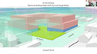
A
total
elevation
of
45
feet
that
could
be
built
out
to
and
looking
into
the
future
with
the
proposal
and
this
rough
model
that
would
bring
us
up
to
a
total
of
70
feet,
build
out
potential.
This
rough
model
encompasses
a
portion
of
the
property
you
can
see.
The
creek
is
still
the
daylighted
portion
of
the
creek
is
still
there
represented
by
this
green
area
here
and
in
this
particular
build.
There
are
five
stories
with
that
upper
floor.
A
A
A
A
You
can
see
some
attempt
to
show
how
articulation
of
the
building
form
could
affect
the
massing
and
reduce
the
the
sense
of
the
building.
In
addition,
we
have
some
site-specific
standards
that
might
be
applied
on
particular
sites.
This
car
wash
site,
for
example,
has
real
potential
to
allow
for
daylighting
of
a
creek,
and
so
we've
shown
that
here
so
there's
no
development
on
that.
A
So
what
are
the
elements
of
the
form-based
code
that
we've
just
looked
at
here
for
one
there's
placement
on
the
street?
There's
the
building
form
the
bulk
and
massing
of
it
where
it
sits
on
the
lot.
What
are
the
setbacks?
We
can
affect
all
of
those
with
this
form-based
code
approach,
there's
also
the
building
standards.
What
do
we
want
the
buildings
to
look
like
what
types
of
architectural
features,
how
much
window
opening
how
much
glazing
where
we
want
the
doors?
A
How
do
we
want
placement
of
you
know
those
those
public
intersections
between
the
private
and
the
public
space,
how
much
landscaping
and
so
on
and
so
forth,
and
then
we
can
also
address
site
design
standards,
including
landscaping.
You
know
these
publicly
accessible
private,
open
spaces.
That
would
be
secured
through
easements
and
other
features
of
the
development
that
really
reflect
on
to
the
public
right-of-way.
A
A
This
very
nice
aesthetically
pleasing
design
could
be
incorporated
onto
the
site
within
that
framework,
and
it's
a
way
of
understanding
how
that
framework
can
then
lend
to
development
of
projects
that
really
enhance
the
area.
The
form-based
code
could
even
go
as
far
as
defining
some
of
these
features,
maybe
where
the
balconies
land,
where
the
openings,
how
how
frequent
the
opening
should
be
for
you
know,
for
public
spaces.
A
This
particular
site
is,
is,
you
know,
filled
up
with
basically
five-story
buildings
and
four-story
buildings,
and
we
can
define
all
of
that.
Obviously,
the
more
definition
we
give
to
the
code,
the
more
detail.
There
is
the
more
time
and
energy
and
money
we'll
have
to
put
into
that
code.
But
if
that's
the
direction,
this
community
wants
to
go
to
ensure
that
it
knows
what
development
is
going
to
come
out
of
this.
A
That
is
an
option,
leaving
the
framework
a
little
bit
more
vague,
maybe
a
little
bit
more
detailed
than
this,
but
a
little
bit
more
vague
will
get
us
to
a
code
more
quickly
and
it
will
allow
for
more
flexibility
and
design,
leave
the
architects
to
do
their
work
and
create
these.
These
really
nuanced
spaces.
A
So
again,
just
recapping
maximum
height
and
building
setbacks
are
sort
of
the
first
layer
design.
There
are
several
more
that
can
be
implemented.
The
form
based
code
would
further
refine
setting
boundaries
on
development,
including
not
only
the
upper
floor
setbacks,
but
up
to
and
including
how
much
glazing
is
on
the
frontage.
You
know
what
those
street
amenities
would
be
where
the
public,
accessible,
private,
open
space
would
be,
and
the
forum
based
code
provides
standards
on
a
range
of
facets
for
development
that
go
beyond
that,
including
potentially
street
trees
and
etc.