►
From YouTube: Where's Brian?
Description
On this episode of Where’s Brian, we’ll be working with a group of people that protects us in a disaster, even though they don’t have lights or sirens. The staff here predicts the future to keep people safe. Do you know where I am today?
A
On
today's
episode
of
where's
brian
we're
working
with
a
group
of
people
that
keeps
you
safe
during
a
disaster,
even
though
they
don't
have
lights
and
sirens,
this
group
predicts
the
future
to
keep
you
safe.
Do
you
know
where
I
am
today,
I'm
brian
phillips?
On
most
days,
I
work
in
an
office
for
the
ames
city
manager,
since
starting
here
I've
learned
a
lot
about
the
different
jobs
city.
Employees
have
many
of
them.
A
A
A
B
B
Sure
it's
the
administration
division
of
the
water
and
pollution
control
department.
So
it's
the
two
engineers,
the
environmental
specialist
and
then
the
director
and
assistant
director
are
the
primary
people
who
are
involved
in
this
task.
There's
other
people
that
can
help
out
and
step
in
in
a
time
of
need
and.
B
Exactly
we
have
three
usgs
gauges
that
are
always
running
and
there
are
several
more
scattered
throughout
story:
county
boone,
county
and
up
into
webster
county
a
little
bit
that
collect
rainfall
data,
some
of
them
monitor
stream,
gages
and
river
levels
for
us.
So
there's
lots
of
information
coming
in
that
we
use
okay.
B
A
B
A
C
C
A
C
Yeah
the
biggest
thing
when
you're
modeling
for
the
flood
model
that
we
have
is
knowing
what
this
stage
level
is,
or
the
height
of
the
water
at
a
given
time,
because
that's
what
tells
you
where
there's
going
to
be
flooding
or
if
there's
even
going
to
be
flooding,
okay
and
so
the
need
for
for
good
data
is,
is
very
important.
And
so
that's
what
we're
doing
here.
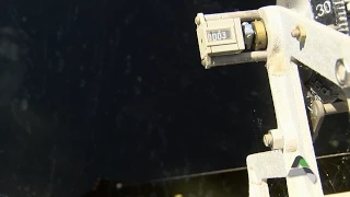
C
So,
as
you
can
see
here,
we've
got
this
weight
attached
this
this
wire
here
there's
a
counter,
a
ticker
that
measures.
It
knows
the
distance
of
the
weight
down
to
the
water
and
it
can
tell
you
the
height
of
the
water
as
kind
of
a
manual
reading.
Okay.
So
what
we're
going
to
do
is
I'll.
Let
you
do
this,
but
we
lift
up
this
and
you
slowly
reel
it
down
to
the
water
until
you
see
the
water
kind
of
ripple.
You
know
it's
reached
the
surface.
Okay
and.
C
A
A
A
C
C
A
C
A
C
C
C
So
the
first
thing
we
need
to
do
and
I've
entered
before
we
came
here
today.
I've
entered
much
of
the
data
for
some
of
the
other
gauges
throughout
the
watershed,
but
we're
going
to
have
you
enter
the
data
from
the
gauge
we
were
at
earlier
today,
all
right
so
skunk
north.
We
have
a
table
here,
an
excel
spreadsheet,
with
the
data
in
it,
and
this
has
the
stage
gauge
data
there
for
every
15
minutes,
like
we
had
discussed
so
you're,
going
to
copy
that
and
put
it
into
the
model
directly.
C
C
C
A
C
So
we
can
do
the
skunk
river
and
we'll
actually
for
this
we'll
actually
just
start
at
so
at
the
ada
hayden
at
the
skunk
north
gauge,
which
is
right
here
and
we'll
just
look
at
what
the
prediction
is
for
that.
So
right,
click
on
that
and
go
to
view
results
and
we'll
open
a
graph
here
and
see
what
we
got.
C
A
C
A
C
That
is
the
data
that
you
entered
and,
as
a
model
run,
goes
on
as
an
event
goes
on,
we'll
update
that
as
we
get
more
data
from
from
the
different
gauges.
Okay,
the
hashed
yellow
line
here
is
our
prediction,
and
that's
the
one
that
we
really
want
to
make
sure
is
matching
the
the
observed
stage,
data
that
we're
getting
and
that's
what
we
use
to
make
a
flood
prediction
for
a
crest
at
that
location,
so
that.
A
C
We
use
our
model
uses
all
the
gauge
data
that
we
have
available
to
us,
and
I
mean
sometimes
we
even
take
into
other
things
into
account.
Occasionally
we'll
run
scenarios
where,
if
we
know
maybe
national
weather
service
is
forecasting
a
certain
amount
of
rainfall,
we'll
anticipate
that
and
see
what
what
some
scenarios
would
be
in
the
model
I
see,
so
we
use
it
for
a
lot
of
different
things
for
making
a
prediction.
C
C
C
A
C
So
a
watershed,
and
we
have
a
map
up
here
showing
ours,
but
what
a
watershed
is
is
the
entire
land
area
that
collects
water
over
an
area?
Okay,
and
so
you
can
see
our
watershed.
All
the
water
that
comes
through
ends
up
coming
through
the
skunk
river
passes
under
the
highway
30
bridge.
So
all
of
our
water,
in
our
watershed
ends
up
passing
through
there.
At
some
point.
Okay,.
C
We
during
an
event
we
make
the
information
available
through
various
means
through
our
public
relations.
Through
our
website
we
actually
have
developed
a
list
of
locations
that
we
know
are
are
prone
to
flooding
at
different
stage
levels,
and
we
make
that
available
as
well.
There
are
certain
locations
in
the
city
that
we
know
flood
at
a
certain
height
and
that's
been
that
information
from
past
floods
has
been
invaluable
in
making
citizens
aware
of
the
risks
it.