►
From YouTube: R U Ready 2019
Description
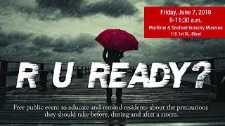
2019 presentation of R U Ready, the City of Biloxi's hurricane preparedness outreach event, was held at the Maritime & Seafood Industry Museum on June 7, 2019. The event included speakers and informational booths.
A
Okay,
hello
and
welcome
to
the
city's
hurricane
preparedness
outreach
event:
are
you
ready?
This
is
our
third
year
to
have
this
event,
and
so
we
thank
you
all
for
coming
out
and
walking
around
getting
some
information
from
the
vendors
and
gathering
information
on
how
to
prepare
for
a
hurricane
or
tornado
or
even
a
flood
event.
A
B
Words
thank
y'all,
so
I
just
want
to
welcome
everybody
here
and
thank
all
the
vendors
and
all
the
different
participants
and
speakers.
You
know
this
is
a
great
event
on
educating
the
public
and
ourselves
on.
You
know
hurricane
preparation,
so
without
further
ado
again,
thank
you.
I
think
we're
going
to
start
with
dmr
patrick
levine.
C
On
behalf
of
the
mississippi
department
of
marine
resources,
I
want
to
thank
the
city
of
biloxi
for
allowing
us
to
be
a
part
of
this.
This
event,
just
a
great
opportunity
to
notify
the
public
and
those
in
our
community
are
the
safety
concerns
we
have
in
the
event
of
a
storm
as
we
get
started.
I
want
to
remind
everybody,
first
of
all
to
heed
the
warnings
of
your
emergency
managers
so
many
times
we
take
those
as
suggestions
and
thinking
about
the
department
of
marine
resources.
C
The
number
one
cause
of
death
in
a
storm
is
rising
water,
and
so
don't
take
those
as
suggestions
when
they
have
those
mandatory
evacuations
but
be
sure
to
to
heed
their
warnings
and
and
get
out.
You
don't
stay
in
those
low-lying
areas
when
a
storm's
coming.
We
want
to
encourage
you
to
have
a
plan
now,
don't
start
trying
to
plan
whenever
a
storm
enters
the
gulf
of
mexico,
but
have
a
have
a
plan
where
you're
going
to
move
that
vessel
when
those
main
mandatory
evacuations
of
harbors
and
marinas
come
in
start
thinking.
C
Now,
where
am
I
going
to
go?
Where
am
I
going
to
tie
it
up?
How
am
I
going
to
get
off
of
the
vessel
get
back
to
where
I
need
to
go
when
I
start
moving
my
equipment
and
my
vessels
provide
ample
time
to
move
a
vessel.
I
know
whenever
I
was
talking
to
chief
geiser
and
amber
about
being
here
today
we
mentioned
talking
about
the
the
vessels
and
marine
traffic
prior
to
a
storm,
and
so
many
times
people
wait
till
the
last
minute
to
move
those
vessels.
C
Don't
wait
to
the
last
minute
make
sure
you
take
care
of
all
that
all
your
property,
if
you
start
to
think
that
there
may
be
an
issue
here
on
the
mississippi
gulf
coast,
go
ahead
and
start
prepping
that
property
ahead
of
time,
so
that
you
can
provide
ample
time
to
make
sure
your
family's
safe
prior
to
moving
that
vessel.
If
you
decide
to
stay
on
the
vessel,
I
want
to
encourage
you
to
do
this.
C
C
I
want
to
remind
you
when
you're
moving,
that
vessel
out
of
the
harbor
marina
when
you're
seeking
refuge
in
safe
harbor,
you
still
can
be
civil,
relatively
liable
and
criminally
liable
for
any
any
damage
or
harm.
That's
caused
from
your
wake
or
negligence
so
be
safe
when
you're
boating
and
moving
that
vessel
to
safe
harbor.
C
When
anchoring
your
vessel
do
not
anchor
and
have
navigable
channels
and
do
not
put
more
in
our
anchor
lines
across
navigable
water.
Make
sure
you
leave
room,
be
courteous
of
other
boaters,
don't
block
channels
when
you're
anchoring
that
vessel
prior
to
a
storm,
and
in
closing
I
want
to
remind
you
that
life
safety
is
paramount.
C
A
C
D
D
Oh,
of
course,
sorry
all
right.
We
have
a
combat
airlift
squadron
over
there
just
got
back
from
the
aor
delivering
beans
and
bullets
to
the
front,
and
then
we
also
have
a
flying
squadron
that
you
might
have
heard
of
the
hurricane
hunters
also
stationed
there
and
we're
very
proud
of
all
the
missions
we
have
on
base.
Today,
I'm
going
to
talk
about
the
hurricane
hunters,
the
technology's,
letting
us
down
a
little
bit.
D
So
hurricane
hunters.
What
do
they
do?
A
lot
of
folks
say:
do
they
really
fly
through
storms
or
they
fly
over
them
yeah?
The
mission
is
to
fly
right
through
them
and
drop
a
little
weather
instrument.
We
call
it
a
drop
sign
right
into
the
middle
of
it
in
the
middle,
as
well
as
the
the
max
wind
bands
which
are
normally
in
the
eye.
Walls
fly
through
punch.
This
little
weather
instrument
weighs
about
a
pound.
D
It's
biodegradable
has
a
gps
in
it
measures
pressure,
but
it
gives
us
pinpoint
data
of
the
storm's
intensity
and
direction
as
we
plot
along
and
fix
it.
So
we're
flying
through
these
weather
systems
to
try
and
get
you
the
best
data
to
try
and
get
basically
the
national
hurricane
center
and
their
forecasters
the
best
information
possible
all
right.
So
a
little
bit
about
how
the
mission
works.
You
know
I'll,
take
you
through
it.
D
We
get
it
or
the
satellites.
A
a
system
comes
off
africa,
or
maybe
the
caribbean
or
bay
campaign
like
that
last
one
where
the
air
masses
are
heating
up,
they
come
over.
They
drift
over
the
the
water
there's
a
natural
tendency
for
those
systems,
hot
cold,
to
start
spinning
a
little
bit,
and
then
they
eventually
become
a
weather
system,
sometimes
with
severe
intensity
and
sometimes
land-based
you
know
to
where
it
becomes
a
factor
for
us.
D
So
how
our
life
works,
starting
about
this
time
of
year,
we've
already
had
a
couple,
is
we'll
get
a
phone
call
or
a
system
is
looked
at.
A
system
of
interest
will
be
found.
Satellite
national
hurricane
center's
got
the
eye
in
the
sky
and
is
constantly
looking
for
this,
we'll
get
a
call
if
it's
in
the
initial
stages.
D
What
we
do
is
a
low
level
invest
we'll
fly
500
feet
to
see
this
tropical
wave
right
hasn't
turned
yet
it's
it's
a
wave
to
see
we'll
go
eyeballs
out
the
window
to
see
if
there's
circulation
in
that
system
and
see
if
it
closes
off
and
becomes
a
tropical
storm.
At
that
point,
we
start
fixing
it
to
find
out
where
it's
heading
and
what
the
severity
intensity
is
of
that
system.
So
it
starts
off
as
low
level.
D
Invest
works
its
way
into
a
fixed
mission
once
we're
in
the
fixed
stage,
again
punching
weather
instruments
through
there
that
information
comes
back
up
to
the
airplane.
It's
q
seed
a
little
bit
quality
controlled
to
make
sure
the
data
is
good.
If
it's
not,
we
come
back
around
and
punch
another
one
through
and
get
that
information
and
beam
it
via
satellite
directly
to
the
national
hurricane
center.
D
They
take
it.
It's
called
burst
data.
They
take
that
information.
It's
not
manipulated
at
all.
It's
taken
right
from
the
system
and
plugged
right
into
the
forecast
models.
Some
of
you,
probably
I'm
sure,
most
folks
that
live
on
the
coast.
Watch
the
weather
channel
a
bunch
you'll
see
the
the
guys
in
the
starch
white
shirts,
starting
to
talk
about
the
weather
system,
inbound.
D
What
it's
doing
and
you'll
see
a
bunch
of
what
we
call
spaghetti
models
right,
these
bunch
of
lines
coming
at
you,
I
think
we're
up
to
about
16
models,
the
canadian
model,
the
gfl.
You
know,
you'll
you'll,
hear
jim
cantori
pick
his
favorite
model
and
why
this
one's
going
this
way
and
why
this
one
here,
but
the
the
the
central
amount
of
models
are
telling
here
telling
us
going
here.
So
what
happens?
Is
you'll
see
that
next
time
do
this
watch
watch
those
models?
D
Spaghetti
models
be
presented,
you'll,
see
they're
all
over
the
place
and
a
couple
outliers
that
are
just
completely
out
to
lunch
as
we
fly
through
those
storms
and
collect
that
and
pump
it
right
into
the
models.
You'll
see
those
things
start
tightening
up
to
a
point
where
the
hurricane
center
can
build
a
more
accurate,
five-day
and
three-day
model
out
of
those
things.
D
D
There's
a
debrief,
a
big
debrief.
We
call
it
the
at
the
end
of
the
season.
It's
called
the
interdepartmental
hurricane
conference
and
which
there's
thousands
of
scientists
all
in
a
room
beating
themselves
up
about
why
the
models
thought
it
was
going
to
curve
here,
but
the
storm
actually
curved
the
other
way,
and
it's
the
the
science
involved
in
this
is
just
unbelievable
and
the
amount
of
interest
and
effort
that
goes
into
that.
D
So
what
I
would
like
to
convey
to
you
is
a
lot
of
folks
are
interested
they're
working
very
hard
they're,
trying
their
best
to
give
you
that
best
five
day
and
three
day
take
heed.
You
know
they're,
that
and
for
our
end
of
it
we're
a
little
bit
on
the
hollywood
side,
but
the
real
heroes
are
the
first
responders,
the
emergency
managers,
city
planners,
everybody
doing
the
real
work
to
set
up
a
city
for
an
inbound
system,
but
we're
glad
to
be
part
of
that
overall
machine.
D
D
We
have
the
best
retention
rate,
because
there's
something
about
us
that
likes
to
you
know
go
do
something
and
see
the
immediate
results
on
tv
as
you
come
back
as
those
models
tighten
up.
So
so
our
folks
love
to
do
it,
but
we
spend
a
lot
of
gas
and
resources
and
I
can't
even
get
into
how
much
maintenance
goes
into
keeping
10
airplanes,
ready
for
a
phone
call
and
16
hours
later
out
the
door.
D
Part
of
the
brief
I
left
off
is
our
forward
operating
location.
A
lot
of
times
is
saint
croix,
as
we
watch
them
coming
off:
cape
cape
verde
off
africa
and
working
its
way
towards
the
us.
So
a
lot
of
times.
The
scenario
is
phone
call.
Sometimes
maybe
it's
already
formed
up
into
a
system
launch
three
planes:
60
people
out
the
next
day,
saint
croix
and
start
hitting
it
around
the
clock.
D
So
it's
very
busy
even
on
years,
where
there's
not
a
lot
of
land
falling,
there's
a
lot
of
what
we
call
fish
killers
where
they
generate
and
just
kind
of
bend
up
back
towards
europe,
but
those
still
can
be
busy
years
for
us
because
we
spend
a
lot
of
gas
money
and
time
and
resources.
But
our
folks
can't
imagine
doing
anything
else
and
we're
glad
to
provide
that
service,
and
I
just
and
I
want
to
with
my
closing
remarks.
D
Thank
the
what
I
consider
the
real
heroes
you
folks
on
the
ground
again,
the
first
responders
and
everybody
has
the
plan
and
put
everything
together
when
there's
one
inbound,
but
we're
glad
to
do
our
part
and,
like
I
said
I'll,
stick
around
for
questions
and
thanks
for
the
privilege
to
tell
you
a
little
bit
about
what
we
do.
Thank
you.
A
A
E
E
This
first
slide
shows
that
50
years
ago
the
mississippi
coast
was
decimated
by
hurricane
camille,
so
camille
pushed
a
24
and
a
half
foot
wall
of
water
into
coastal,
mississippi
and-
and
we
can
see
here-
is
that
coming
up
okay,
this
is
a
rishilu
apartment,
complex
in
past
christian
area,
so
you
can
see
before,
on
top
and
after
on
the
bottom.
This
is
a
power
of
water
moving
across
the
landscape,
and
coastal.
Mississippi
has
had
a
lot
of
really
massive
storm
surge
event.
E
So
in
a
storm
church
event,
a
hurricane
pushes
these
really
strong,
onshore
winds,
and
actually
the
sea
level
can
rise
as
high
as
20
25
30
feet
above
where
it
normally
is,
and
just
really
decimate
the
landscape.
Next
slide.
Please,
today,
I'm
going
to
be
talking
about
in
2008.
When
I
moved
to
the
gulf
coast,
there
was
really
no
historic
storm
surge
database,
and
I
was
you
know,
really
curious
why
that
was
so.
E
F
E
Are
tide
gauges?
We
have
national
hurricane
center
reports
since
1958
we
have
a
lot
of
maps
of
historic
hurricanes
that
have
struck
the
gulf
coast,
actually
zooming
in
on
that
map
on
this
next
slide.
This
is
a
map
of
what
we
sometimes
call
the
forgotten
hurricane
of
1915.
This
was
a
major
hurricane
that
struck
the
new
orleans
area.
Everything
shaded
here
in
gray,
was
inundated
by
salt
water.
E
You
may
not
be
able
to
see
it
from
where
you're
sitting,
but
there
are
a
lot
of
high
water
marks
on
this
map,
so
this
is
1915
104
years
ago.
They
didn't
have
internet
or
cell
phones,
but
they
had
rulers,
tape,
measures
and
pencils
and
pens,
and
they
went
out
and
recorded
these
data.
But
these
data
were
just
in
the
back
of
libraries
and
archives.
E
They
were
not
brought
into
the
modern
day,
and
so
what
I
began
to
see
is
we
could
actually
go
back
to
these
historic
maps,
see
what
happened
and
bring
that
into
the
future.
This
next
slide
goes
back
to
where
we
were
talking
about.
Newspapers
are
a
very
important
resource
going
back,
especially
to
the
early
1900s.
I
just
met
jane
from
biloxi
library.
If
you
haven't
checked
out
her
table,
please
check
it
out.
She
has
a
lot
of
newspaper
clippings
historic
photos.
We
see
high
water
marks
from
a
lot
of
communities,
historic
photos.
E
This
is
miami
in
1926.,
so
we
can
actually
go
back
and
there's
a
tremendous
history
of
saltwater
flooding
along
the
gulf
coast
and
the
atlanta
coast,
and
often
working
with
librarians
historians
digging
into
the
archives.
We
begin
to
see
a
history
of:
what's
happened
in
any
one
location,
so
what
I
began
to
see
when
I
started
looking
into
the
idea
of
building
a
historic
database.
E
My
conclusion
is
that
we
have
plenty
of
observations
to
do
this,
but
I
thought
this
project
could
end
up
really
big
and
if
you
have
a
big
project,
you
need
a
good
acronym.
So
you
know
when
I
started
thinking
of
an
acronym
for
this
project.
I
kept
coming
up
with
this
idea
of
water,
height
observation
data,
and
so
the
only
problem
with
that,
if
you
want
to
turn
this
into
an
acronym,
pretty
much
what
you
end
up
with
on
this
next
slide,
is
who
dat.
So
I
I
thought
I'm
going
to
do.
E
I
can
say
you
know
they're
going
to
look
at
this
stuff
and
say
we
don't
really
know
what's
going
on
there
down
in
the
gulf
coast,
we're
up
in
washington
dc,
but
people
love
this
water
height
observation
data
project.
Just
everywhere
you
go,
people
are
chanting
who
dot.
They
love
this
stuff,
we'll
just
keep
sending
millions
of
dollars
that
was
kind
of
my
initial
research
plan.
Do
the
who
dot
project
and
it'll
it'll
go
big?
We
didn't
end
up
calling
it
huda.
E
We
ended
up
calling
it
surge
dat
and
this
next
slide
shows
an
initial
snapshot
of
what
we
found.
This
is
the
highest
watermark
from
about
200
hurricanes
and
tropical
storms
from
1880
to
present.
Every
dot
on
this
map
is
the
location
and
height
of
a
peak
water
level,
and
what
we
see
here
is
there's
actually
a
pattern
to
it
right.
So
the
larger
darker
circles
are
higher
magnitude
events.
E
So
we
see
a
lot
of
red
and
purple
really
along
the
northern
and
western
gulf
coast
and
then
the
florida
keys,
but
look
at
the
west
coast
of
florida.
You
don't
see
any
red
or
purple.
It
doesn't
mean
that
we
couldn't
get
a
20-foot
storm
surge
in
tampa
bay,
but
it
just
shows
that
that's
a
lot
less
likely
than
getting
a
20-foot
storm
surge
in
the
galveston
area.
So,
incidentally,
the
two
highest
water
marks
I
found
since
1880
were
both
here
in
mississippi
from
hurricane
camille
and
hurricane.
E
Thought
at
first
what
a
coincidence
that's
the
same
plot.
The
same
spot
would
get
the
two
highest
water
marks.
I
began
to
see
after
some
time.
It
actually
was
not
a
coincidence
and
really
there's
a
reason
for
it.
But
the
the
one
limitation
of
this
is
that
every
storm
it
just
shows
up
as
one
dot
on
the
map,
but
we
know
if
you've
lived
along
the
gulf
coast,
these
hurricanes
can
indicate
hundreds
of
miles
of
coastline
with
salt
water,
and
so
what
I
started
doing
in
2012
was
building
these
whole
envelopes
of
water.
G
E
Clark
will
tell
you
all
about
the
experience
of
his
family's
home
there
in
dauphin
island,
so
really
starting
to
do
this
and
getting
the
whole
envelopes.
We
could
actually
take
any
location
along
the
coast
and
start
to
build
an
entire
history
of
what's
happened
there,
and
this
next
slide
shows
what
we've
been
doing
with
the
usurge
project.
E
The
following
slide
shows
you
that
this
is
a
history
that
we
built
for
pensacola
florida,
so
this
is
going
from
1880
to
present
for
pensacola.
This
is
sea
level,
which
is
rising
over
time
and
mostly
what
we
see
here
is
these
low
magnitude
events
with
two
or
three
or
four
feet
of
salt
water.
Most
of
these
events
are
really
low,
either
from
a
powerful
hurricane
that
hit
far
away
or
a
weaker
hurricane
nearby.
E
But
through
history
we
see
three
times:
1906
1926
and
hurricane
ivan
in
2004,
where
we
had
a
powerful
hurricane
hit,
just
the
wrong
spot
for
pensacola,
and
what
we
see
here
in
many
of
these
communities
is
that
there
will
be
two
or
three
historic
hurricanes
that
produce
tremendous
amounts
of
salt
water.
That's
much
higher
than
everything
else,
but
look
at
this
more
closely.
You
get
people
say
well.
I've
lived
here
for
50.
F
E
They
came
in
maybe
1969.
and
as
far
as
really
high
events
in
a
place
like
pensacola
they're,
only
going
to
remember
ivan
they're
going
to
think
that
was
a
million-year
storm.
Nothing
was
ever
like
ivan.
It
was
so
much
higher.
But
if
you
look
back
far
enough
into
the
20s
turn
of
the
century,
you
start
to
see.
Actually
there
wasn't
one
ive
and
there
were
three
and
so
a
place
like
mississippi
coast.
E
Katrina
is
more
recent,
but
you
know
it's
great
to
see
this
place
here,
doing
a
50-year
anniversary
for
camille,
because
katrina
was
higher
than
camille
but
same
ballpark.
They
both
were
putting
between
25
and
30
feet
of
salt
water
here.
So
we
really
need
to
understand
the
deeper
history
for
these
communities
to
understand
our
risk.
The
next
slide
goes
into
fema's
base
flood
elevation
for
a
place
like
pensacola,
seven.
I
C
E
When
it's
been
exceeded
more
than
two
to
three
feet
three
times
in
history,
this
is
common
for
most
gulf
coast
communities.
I
found
that
the
the
base
flood
elevation
that
we
require
people
to
build
to
has
been
exceeded
multiple
times
by
multiple
feet.
The
next
slide
gets
into
some
of
this
work.
I've
done
globally.
Looking
at
at
storm
surges
all
around
the
world.
I
actually
built
the
first
global
storm
surge
database,
looking
at
six
ocean
basins
and
actually
in
the
western
hemisphere.
E
We
have
western
north
atlantic
and
the
eastern
pacific
and
the
higher
storm
surges
actually
happen
in
the
western
north
atlantic.
Globally.
The
highest
surges
in
the
world
happen
in
the
northern
indian
ocean
and
number
two
in
the
world
is
actually
right
here
along
the
mississippi
coast.
So
we
have
a
big
vulnerability
to
this
hazard.
This
this
next
slide
goes
into
basically
time
from
1880.
To
present
we
have
four
ocean
basins
and
really.
E
Here
of
really
like
eight
katrinas
in
about
15
years
in
bangladesh
and
india,
which
was
the
most
horrific
time
in
the
history
of
the
world,
but
the
big
picture
to
focus
on
if
you're
in
the
western
hemisphere,
you're
green
and
the
two
highest
high
water
marks
were
camille
and
katrina
again
talking
about
the
us,
the
entire
western
north
atlantic.
The
highest
events
we've
ever
seen
on
record
are
right
here
in
mississippi.
The
next
slide
gets
into
understanding.
Why
is
that?
Is
that
just
random?
Or
is
there
a
reason
to
it?
E
They're
really,
five
variables
that
affect
storm
surge
height,
one
is
the
hurricane
size.
So
we
often
hear
about
this
category
number,
but
the
category
number
just
has
to
do
with
the
sustained
winds.
The
geographic
size
of
a
of
a
katrina
or
an
ike
are
really
large
storms
that
push
a
lot
of
salt
water.
The
next
slide
gets
into
the
hurricane
forward
speed.
So
look
at
the
picture
from
this
next
slide
here.
This
is
hurricane
isaac.
E
Anyone
remember
that
from
from
2012
it
was
a
category
one,
but
just
just
parked
for
a
few
days
and
actually
was
able.
It
was
large
and
it
didn't
move
and
it
was
able
to
push
more
than
11
feet
of
salt
water
into
parts
of
mississippi.
So
a
low
category
storm
quote
unquote,
but
did
a
lot
of
flooding.
Here's
a
picture
from
long
beach,
mississippi
the
next
slide
gets
into
looking
at
offshore
bathymetry.
So
that's
a
fancy
scientific
word
for
basically
topography
offshore.
How
deep
is
your
water
offshore
and
it's
counter-intuitive?
E
Actually,
the
more
shallow
your
water
is
the
higher
the
storm
surge,
and
this
graphic
here
shows
you
really
how
many
of
you
have
ever
been
to
a
volcanic
island
like
hawaii
places
in
the
caribbean?
How
far
do
you
have
to
walk
offshore
to
get
over
your
head
in
water?
Not
very
far,
the
water
gets
really
deep,
really
quick
and
so
the
hurricane
pushes
in
and
then
this
is
the
storm
surge.
E
How
high
your
sea
level
is
rising,
not
very
much
if
you're
in
a
place
like
hawaii,
but
look
at
these
huge
surf,
these
huge
waves
that
you
can
surf
on
or
you
wouldn't
in
a
storm,
but
that
type
of
wave
are
tremendous.
So
compare
that
with
a
place
like
mississippi
on
this
next
slide,
very
shallow.
How
far
do
you
have
to
walk
out
here
to
get
over
your
head
in
water?
You
have
to
walk
quite
a
distance
right.
It's
very
shallow
and
this
hurricane
pushes
in
all
this
water.
E
E
E
This
next
slide
gets
into
one
more
thing:
the
coastal
shape.
Look
at
this
map
here
of
hurricane
katrina.
You
can
see
the
counterclockwise
rotation
look
at
the
coast
in
the
northern
gulf
coast.
We
kind
of
have
this
right
angle,
so
the
mississippi
river
delta
louisiana
sticks
out,
and
so
really
we
get.
These
prolonged
easterly
winds
as
a
hurricane's
approaching,
and
this
water
will
just
pile
up
here.
It
just
gets
really
piling
up
there
along
the
right
angle
and
that's.
E
You
know
so
it's
shallow
and
we
have
this
angled
coast
that
just
piles
water
in
this
area.
So
there
are
reasons
why
we're
very
vulnerable
here
to
salt
water
flooding.
I
finally
just
wanted
to
wrap
up
with
pre-landfall
intensity
and
size,
so
the
intensity
of
the
storm
before
it
hits
coast
also
has
something
to
do
with
this.
E
So
next
I
wanted
to
get
into
just
the
rise
of
flood
information
systems,
and
you
know
basically
what
I've
been
doing
in
recent
years
is
not
only
looking
at
hurricane
history
and
saltwater
history,
but
look
at
this
next
slide.
This
is
a
picture
of
galveston
island,
so
I
lived
in
galveston
a
few
years
and
you
can
see
the
difference
in
home
elevation.
So
even
if
we
knew
that
there's
going
to
be
three
feet
of
water
over
the
landscape,
different
elevations
of
homes
will
you
know
shows
that
there's
a
different
risk
as
far
as
inundation.
E
This
next
slide
here
shows
you
know
trying
to
get
this
first
floor
elevation,
that's
something
that
we've
been
working
on
for
a
few
years
stuart
and
I
and
carl-
and
I
work
on
some
projects
like
this-
we're
interested
to
build
a
inventory
of
first
roll
first
floor
elevations
for
communities.
This
next
slide
shows
a
project
that
we
did
in
galveston,
texas,
where
you
can
actually
select
the
type
of
storm.
E
E
Inside
them
from
100-year
flood-
and
this
next
slide
here
shows
norfolk
virginia,
we
just
did
first
floor
elevations
and
compared
it
to
this
base.
Flood
elevation
that
we're
supposed
to
build
to
everything
in
blue
is
not
built
to
that
level.
These
older
homes
that
were
grandfathered
in
33
of
them
are
not
at
that
level
that
that
is
considered
the
base
flood
elevation,
so
these
are
projects
that
we
can
do
with
communities
working
alongside
them.
Finally,
one
more
map
shows
where
we're
going
with
this.
We
could
take
a
community.
E
This
next
slide
shows
we
could
actually
have
you
know
water
levels
that
we
estimate
were
in
homes
during
a
storm
and
then,
finally,
with
we
call
this
flood
information
systems,
we're
interested
to
tie
a
lot
of
information
into
any
one
home.
So
what's
the
elevation
of
the
home,
does
it
have
an
elevation
certificate?
How
is
it
constructed?
E
What
kind
of
roof
does
it
have?
What
kind
of
walls
does
it
have?
What's
the
chance
of
flooding
a
30-year
mortgage?
Have
there
been
previous
floods?
These
are
the
kind
of
things
that
we
want
to
build
into
a
flood
information
system.
We
just
put
in
a
grant
with
the
city
of
biloxi
to
actually
build
an
information
system
like
this
for
biloxi
and
we're
hoping
that
we
can
get
it.
I
mentioned
up
here,
the
fortified
fortified
wind,
yes,
and
no,
how
many
of
you
are
familiar
with
the
fortified
project?
E
Have
you
heard
of
this
before
so
carl
schneider's
here
he's
really
headed
up
that
project
in
alabama
and
really
it's
a
standard
to
build
better
so
that
people
are
better
prepared
and
that
their
homes
are
better
constructed
for
wind
and
we're
hoping
for
flood
as
well.
I
wanted
to
wrap
up
with
just
a
few
more
seconds,
stuart
and
I
were
just
up
in
washington
dc
for
the
national
flood
conference
and
we're
really
excited
about
the
fortified
project
that
carl's
doing.
E
I
walked
into
this
ballroom
at
this
conference
in
washington
d.c
and
there
were
hundreds
of
people
there.
I
heard
three
conversations
right
off
the
bat
where
people
were
talking
about
fortify.
I
couldn't
believe
it.
I
went
up
to
this
one
group
I
was
listening
and
I
said,
are
you
talking
about
alabama
fortified
and
this
big
guy?
I
think
he
was
from
south
carolina.
He
said
alabama
fortified,
he
said
son,
I'm
not
talking
about
fortified.
He
said
we're.
Gonna
grab
some
beers
from
four
to
five.
So
I'm
sorry,
carl
carl.
E
I
got
all
excited
we're
not
quite
there
yet,
but
but
people
are
excited
about
your
project
so
anyway,
thanks
so
much
for
having
me
here
today.
My
contact
information
is
on
this
last
slide
here,
but
we're
excited
to
work
with
communities
along
the
gulf
coast,
build
that
flood
history
build
that
inventory
of
first
row
elevation,
so
we
can
kind
of
understand
the
flood
risk
and
the
impacts
of
it
economically
and
across
the
city
as
a
whole.
A
Thank
you
so
much
doctor
that
was
a
wealth
of
information
and
very
interesting
data.
Now
I
want
to
welcome
up
rupert
lacy
and
matt
stratton
they're
with
harrison
county
emergency
management
agency,
they're,
going
to
talk
about
the
2018
hurricane
season,
hurricane
threat,
watches
and
warnings,
personal
preparedness,
evacuation
sheltering
and
the
2019
season
forecast
welcome.
Thank
you.
J
Of
course,
it's
our
pleasure
to
be
here
in
biloxi
for
the
ru
reddy
campaign,
of
course
the
season's
already
started.
I
want
to
thank
the
hurricane
hunters,
of
course,
for
not
flying
91l,
but
it
has
helped
us
in
the
preparedness
message
this
week
is
that
system
did
rollovers?
Hopefully
it's
out
of
here
today
and
we
get
ready.
2018
was
a
very
unique
season.
Remember
that
we
saw
two
storms
hit
the
mainland
u.s
of
a
one
on
our
east
coast
in
south
carolina
north
carolina.
J
My
understanding
florence
has
been
retired
as
a
name
now
and
then
we
think
about
hurricane
michael.
I
look
at
a
lot
of
you
in
this
room.
We
were
talking
about
that
in
october
of
last
year.
It
was
a
very
quick
spin-up
storm.
It
was
one
that
took
our
plans
off
the
shelf
and
we
had
within
72
hours
to
prepare,
and
we
did
a
couple
historical
things
here.
J
On
the
mississippi
gulf
coast,
we
shut
the
casinos
down
and
24
hours
later
we
opened
the
casinos
back
up
and
we
were
spared
that
category
5
storm
that
impacted
bay,
county
of
course,
city
of
mexico
beach
and
we're
sorry
for
their
loss
and
and
the
devastation
that
they're
going
through,
but
it
it
did
remind
us
of
the
2005
year
and
or
the
two
our
1969
year.
If
that
storm
would
have
come
in
here.
What
would
we
be
doing
today?
J
What
we
want
to
encourage
is
one
you
prepare
and
the
the
message
that
we
really
want
to
kind
of
push
this
morning
before
we
get
into
the
2019
season
is
have,
are
you
prepared
personally
and
when
we
say
this,
do
you
have
that
go
kid?
Are
you
ready
to
go?
I
look
at
the
responders
in
here
and,
and
that
message
is
48
hours
prior
to
landfall.
J
Every
responder
in
here
is
already
engaged
at
work.
Is
that
we've
gone
to
those
unfortunately
12-hour
shifts,
if
not
24-hour
shifts,
and
we
are
trying
to
to
prepare
the
residents
for
what
is
about
to
happen
to
the
mississippi
gulf
coast
that
water,
that
water
level
is
our
big
concern.
As
we
stand
here
on
the
island
of
the
big
island
of
harrison
county,
we
want
you
to
remember
that
we
have
water
all
the
way
around
us.
J
You
know,
as
as
I've
said
and
as
the
history
will
show,
the
bay
of
st
louis
does
meet
the
bay
of
biloxi.
Once
you
go
back
into
the
waterways
through
the
big
eye
or
the
big
lake
and
get
into
the
industrial
canal
which
is
developed
in
there.
That
gets
into
our
to
shoot
our
the
flat
branch
and
the
turkey
creek
river,
which
goes
over
to
long
beach
into
canal,
one
and
two
those
actually
are
little
creeks
that
comes
back
to
bio
potash,
which
goes
into
the
bay
of
st
louis.
J
So
you
are
on
the
big
island.
It
is
like
gulf
shores,
it
is
like
our
neighbors
to
the
east,
and
what
we
want
you
to
do
is
to
prepare
and
get
ready
to
get
off
the
big
island
when
we
start
looking
at
those
high
surge
values
that
the
the
weather
service,
the
hurricane
center
has
really
started
to
hone
in
on
us
as
to
what
the
values
are.
J
K
Well,
thank
you,
sir,
and
I'll.
Try
to
keep
the
news
not
too
bad.
If
we
could
flip
to
the
next
slide
a
couple
of
topics
we're
going
to
be
covering
today
the
the
threat,
our
own
personal
preparedness
last
season
in
a
little
more
detail
as
rupert
has
already
got
that
going.
Revisit,
watches
and
warnings
make
sure
everybody
understands
what
we're
talking
about
there
and
then
a
couple
of
topics
as
far
as
protective
actions
are
concerned,
are
evacuations
and
sheltering,
and
then
finish
up
with
the
outlook
for
this
2019
season.
Next
slide,
please.
K
So
the
the
hurricane
threat
is
very
real
for
our
communities.
It's
happened
before
it
will
likely
happen
again
and
so,
as
the
tropical
areas
grow
and
develop
and
move
towards
us,
those
steering
currents
do
track
systems
from
the
caribbean
and
the
gulf
in
towards
us.
It
is
a
eye-opening
chart
to
see
there
on
the
right-hand
side,
all
of
the
systems
that
have
landfalled
along
the
gulf
coast
and
as
those
systems
come
in
as
was
mentioned
earlier,
the
storm
surge
is
a
definite
threat
for
our
area,
but
that's
not
the
only
hazard
associated
with
these
storms.
K
K
All
that
water
falling
as
rain
has
to
go
somewhere
and
as
it
falls,
it
fills
the
low-lying
areas
and
then
comes
downstream
towards
the
coast
and
then
tornadoes
another
threat,
especially
on
that
right
front.
Quadrant
of
the
storm.
We
need
to
be
prepared
for
all
of
these
hazards
associated
with
the
hurricanes
next
slide.
Please
and
preparedness
means
for
ourselves
our
families
and
our
workplaces.
K
K
K
You
don't
want
to
be
losing
your
birth
certificates.
Your
other
important
documents
make
sure
those
go
with
you
in
your
go
bags.
Next
slide,
please.
So
last
season,
as
rupert
mentioned,
was
very
active.
We
saw
numbers
of
storms
above
what
is
average.
If
you
look
out
over
100
years,
the
average
number
of
storms
is
12
named
storms,
six
hurricanes
and
three
of
those
hurricanes
being
major
hurricanes.
K
So
last
season
being
an
active
season
as
these
storms
do
progress
in
towards
us.
The
weather
professionals
at
the
national
hurricane
center
national
weather
service
in
slidell
and
our
our
noaa
partners
are
going
to
be
getting
the
information
out
to
us
next
slide,
please
with
watches
and
warnings.
So
just
to
make
sure
everybody
is
aware.
The
watch
is
letting
the
community
know
that
it
is
possible.
K
You
will
be
getting
alerts
through
your
cell
phones
as
well,
and
you
don't
have
to
sign
up
for
wireless
emergency
alerts.
The
national
weather
service,
through
the
the
notification
systems,
is
going
to
send
that
directly
to
phones
through
the
cell
towers
of
affected
areas,
and
so
those
will
pop
up
into
your
phones
just
make
sure
you've
got
w-a-w-e-a's
turned
on
in
your
settings
on
your
cell
phone,
but
the
watch
is
letting
people
know
that
it
is
possible.
K
It
is
now
time
to
start
taking
those
protective
actions
and,
as
the
system
moves
closer
once
we
get
to
the
36
hour
point,
those
watches
will
then
be
upgraded.
Two
warnings
at
that
point.
We
are
expecting
those
conditions
and
the
the
last
several
years
the
hurricane
forecasters
have
gotten
very,
very
good
at
predicting
where
these
storms
are
going.
So
once
it
gets
upgraded
to
the
warning,
you
can
pretty
much
bet
that
we
are
going
to
be
seeing.
Those
conditions
expect
them
to
occur
now.
K
The
last
couple
of
years,
because
of
the
threat
that
storm
surge
does
pose,
the
weather
service
has
started
putting
out
specifically
a
storm
surge
watch
and
a
storm
surge
warning,
and
so
for
areas
that
are
expecting
those
conditions,
look
for
the
storm
surge
watch
and
the
storm
surge
warning
to
be
put
out
next
slide.
Please,
okay,
so
once
the
watches
and
the
warnings
are
put
out,
we're
going
to
be
taking
those
protective
actions
and
evacuations
are
a
a
great
tool
that
we
have
in
our
tool
kit.
K
Everybody
needs
to
understand
what
their
evacuation
zone
is,
though
we
have
two
in
harrison
county.
You
see
those
represented
in
the
red
and
the
yellow
areas,
and
so
make
sure
you
understand
where
your
home
is
where
it
lies
in
an
evacuation
zone
where
your
workplace
is
and
make
sure
that
everybody
understands
what
their
specific
risk
is
associated
with
those
zones.
K
K
K
Initia
situation
is
going
to
family
or
friends
in
inland
and,
if
that's
not
an
option
for
you,
a
hotel
or
a
motel,
but
understand
that
a
lot
of
people
are
going
to
be
competing
for
these
same
hotels
and
motels
regardless,
you
need
to
get
to
a
sturdy
building
away
from
the
coasts,
the
rivers
and
the
creeks.
It
is
the
water
rising
water
that
is
the
primary
killer,
and
you
need
to
get
to
a
sturdy
building
away
from
those
rivers.
Coasts
and
creeks.
K
Emergency
shelters
are
a
last
resort.
It
is
a
temporary
place
to
go
away
from
the
wind
in
the
water
it's
going
to
be
safe,
but
likely
not
what
you
would
call
comfortable,
and
so,
if
at
all
possible,
we
would
recommend
going
to
family
and
friends
or
to
hotels
and
motels
inland.
The
shelters
will
be
a
last
resort.
Next
slide,
please.
K
So
looking
ahead
to
the
upcoming
season,
2019
looks
to
be
an
active
season
and
both
the
the
weather
forecasters
at
noaa
and
colorado
state.
Many
other
partners
they're
telling
us
that
all
of
their
predictions
are
that
it's
going
to
be
a
near
normal
season.
So
for
us,
the
information
for
us
is
to
expect
that
active
season
and
to
take
this
time
now
to
prepare
to
set
yourself
up
for
success
when
we
do
have
any
system
that
potentially
moves
into
our
area.
K
K
The
national
weather
service,
noaa
hurricane
center
does
put
out
a
five-day
tropical
outlook
and
we
really
recommend
you
check
this
regularly
throughout
hurricane
season.
They
will
mark
the
areas
that
are
potentially
able
to
develop
and
they'll
give
it
a
percentage,
a
low,
medium,
high
chance
of
development,
and
this
will
give
you
five
days
looking
out
in
the
future
to
help
you
plan
and
prepare.
So
I
really
recommend
people
monitor
this
regularly
from
the
national
hurricane
center.
You
just
go
to
hurricanes.gov
and
it'll
be
right
there
for
you.
K
A
F
Safety,
thank
you
how's
everybody
doing
today,
good
my
like
my
name
is
archie
reeves.
I
work
mississippi
power
company
I'll,
give
you
a
little
history
of
what
happens
before
the
storm
gets
here
once
we
determine
that
we're
going
to
be
our
service
territory
is
going
to
be
affected
by
a
storm.
What
we
do
is
we
start
getting
on
the
phone
and
we
start
bringing
other
utilities
in
and
help
in
to
get
as
close
as
they
can
get
in
and
still
be
safe.
F
F
One
of
the
things
that
we're
very
concerned
with
is
generators,
generators
and
properly
installed.
Generators
can
backfeed
out
on
the
power
lines
and
those
lines
be
sitting
there
energized
on
the
ground.
So
one
of
the
things
we
ask
that
you
do
is
to
follow
your
instructions.
Your
generator
safety
instructions,
do
not
try
to
back
feed
them
like
take
a
generator
and
plug
it
into
a
wall
receptacle
and
then
back
feed
through
the
house,
because
that
way
it
can
get
back
out
onto
the
system.
F
Another
safety
hazard
involved
with
generators
is
people
fear
that
you
know
my
house
is
on
generator,
I'm
afraid
somebody's
going
to
come
up
in
the
middle
of
the
night
and
steal
my
generator
so
they'll
put
their
generators
on
car
ports
and
put
your
generators
up
close
to
a
house.
What
you
don't
want
it
happening
is
carbon
monoxide
poisoning
from
a
generator?
F
F
F
A
A
I
Thank
you,
hi
everyone.
My
name
is
casey
harrison,
I'm
the
director
of
animal
services
at
the
humane
society
of
south
mississippi.
I
just
want
to
go
over
a
few
key
points
with
you
today
for
being
prepared
to
evacuate
with
your
pets.
You
should
always
make
sure
that
you
have
your
current
animal
vaccination
records
with
you.
I
Rabies
vaccinations
are
extremely
important
if
your
pet
is
microchipped,
make
sure
that
your
information
is
current
and
up
to
date,
if
your
pet
is
not
microchipped,
we
offer
that
at
the
shelter
any
time
of
year
right
now
we
actually
have
a
vaccination
and
microchip
package
that
we
do
during
hurricane
season,
where
you
can
come
in
and
get
your
pet
microchipped
and
a
rabies
vaccination
for
twenty
dollars,
you'll
just
come
into
our
spay
and
neuter
clinic.
You
do
not
have
to
have
an
appointment
to
come
in
for
that.
I
Any
evacuation,
shelters
that
you're
going
to
to
make
sure
that
they
also
allow
pets
to
be
brought
with
you
to
those
as
well
make
sure
that
you
have
enough
food
water
to
transport
with
your
animal,
because
you
don't
know
how
far
away
you're
going
to
have
to
go.
And
you
don't
know
how
long
it's
going
to
be
before
you
can
get
back
to
where
you
might
be
able
to
purchase
food
for
your
animal.
I
A
F
L
L
If
it's
a
small
storm,
our
public
works
is
able
to
come
in
there
and
they're
capable
of
moving
all
the
debris
that
needs
to
be
removed
to
clear
our
streets
out.
If
it's
a
larger
storm,
the
city
has
a
contract
with
a
company
that
will
come
in
and
they
have
a
lot
of
manpower.
They've
got
a
lot
of
trucks
and
vehicles
to
be
able
to
do
the
removal
themselves
they
have
in
the
contract.
L
They
have
up
to
70
hours
to
be
here
to
start
that
removal
in
the
past
they've
been
much
quicker
than
70
hours,
but
they
have
up
to
that
time.
It's
important
to
move
the
debris
from
the
streets.
You
need
your
buses
and
your
fire
and
your
police
amr
utility
companies.
I
mean
if
they
don't
have
access
to
from
point
a
to
point
b.
Nothing
happens
after
they
remove
the
debris
from
the
streets.
They'll
go
back
and
they'll
make
several
passes
through
the
neighborhoods
and
individual
streets
to
remove
debris
from
private
residents.
L
L
You
got
you
got
10
foot,
you
can
put
it
up
to
10
foot
past
the
curb
onto
your
property
and
they'll,
get
they'll,
remove
they'll,
be
able
to
move
the
debris
off
your
property.
Then
there's
several
categories.
I
think
there's
six
categories
that
they
ask
that
you
have
separate
piles
once
for
electronics,
one's
for
large
appliances
and
just
visit
vegetation
and
house
garbage
if
you
could
put
them
in
different
piles
for
some
reason
it
helps
them
out.
So
I
say
we
do
that.
L
Next,
to
you
know,
mailbox
or
tree
stumps
it,
it
slows
the
process
down
and
that's
not
good
for
anybody,
so
if
they
can
get
in
and
get
out
the
quicker
they
can
do
that
the
quicker
we
can
get
to
walmart
get
back
to
work.
So
so,
if
you
have
any
questions,
ask
me
I'll
be
in
the
back
of
the
room
and
y'all
can
pass
that
one
around.
A
H
I'm
kevin
coggin,
director
of
coast,
transit
authority,
we've
been
through
quite
a
few
of
these,
I'm
a
native
biloxi,
lifelong
resident
of
the
coast,
I've
been
through
camille
and
katrina
and
I'm
trying
to
make
it
another
four
and
a
half
years
to
retire,
for
we
have
another
one.
So
I
got
my
fingers
crossed.
Let's
let
these
younger
folks
take
you
see
all
this
gray
hair.
H
So
I'm
going
to
talk
about
before
storm
and
after
a
storm
there's
two
things
we
do
and
the
easiest
thing
we
do.
We've
learned
is
evacuation
because
that's
a
short-term
operation,
so
we're
part
of
the
harrison
county
emergency
management
agency.
We
man
organ,
manage
the
transportation
component,
we're
actually
in
the
emergency
operations
center.
When
rupert
and
his
staff
open
the
emergency
operations
center,
we're
there,
we
have
somebody
there,
I'm
there.
He
has
a
great
staff.
He
does
a
great
job,
they're
very
experienced
when
we're
under
a
hurricane
warning.
H
Rupert
lacy
is
the
boss
at
harrison
county.
Basically,
I'm
really
proud
of
the
job.
They
do
so
all
the
resources
that
the
community
needs
are
at
his
disposal.
So
if
our
citizens
need
something
it's
going
to
get
done
and
and
we're
going
to
work
together,
I
want
to
assure
you
that
so
our
role
to
play
before
hurricane
is
getting
you
to
a
shelter
of
last
resort.
That's
key!
We
want
you
to
leave.
H
We
want
you
to
have
a
plan,
but
if
you
can't
leave,
we
don't
want
anybody
to
be
left
in
harm's
way
because
they
don't
have
transportation.
That's
where
we
come
in.
We
provide
curb
to
curb
transportation,
to
a
shelter,
only
shelter
or
less
resort,
there'll
be
four
or
five
shelters
or
more
that'll
open.
That's
rupert's
call,
depending
on
the
severity
of
the
storm.
H
H
We
have
a
registration
system,
a
pre-registration
system.
I
highly
encourage
the
community
to
take
advantage
of
that.
It
helps
me.
Let
us
know
my
organization
what
kind
of
resources
we
need
ahead
of
the
time
and
we
know
where
you
are-
and
you
all
have
already
told
us
you
need
help.
We
put
you
in
our
database
and
we
actually
have
an
automated
call
out
system
where
our
system
will
call
you
with
a
message
and
will
say
something
like
a
harrison
county.
Emergency
management
agency
has
ordered
an
evacuation
of
your
zone,
call
coast,
transit
authority.
H
H
What
we
do
the
amount
of
of
service
we
do
depends
on
the
severity
of
this
storm.
We
all
know
that
if
it's
a
low-level
storm
people
are
are
not
going
to
vacuum.
If
it's
a
cat
5
we're
all
going
to
get
scared
right,
including
me
and
evacuate
so
after
the
storm,
we're
going
to
get
you
back
where
you
need
to
be.
H
If
we
have
a
devastating
event
like
a
camille
or
katrina,
we're
going
to
be
working
with
the
emergency
management
agency
and
we're
going
to
establish
what
kind
of
service
does
coast
transit,
your
public
transit
agency
need
to
be
doing
to
help
the
community
get
back
on
their
feet.
Where
are
the
fema
help
places
at
if
you
lost
your
house
where
you
know?
Where
are
the
shelters?
People
are
going
to
live
at?
Where
are
the
points
of
distribution?
H
So
we're
going
to
know
all
that
and
we're
going
to
provide
transportation
to
help
the
community
get
to
help
help
the
community
get
back
on
their
feet
after
hurricane
katrina?
We
ran
free
public
transportation
service
for
three
months
to
help
our
community
get
back
on
their
feet.
We
had
people
lost
their
homes,
lost
their
cars,
so
whatever
we
need
to
do
to
help
you
that's
what
we're
going
to
be
doing
so.
Watch
your
tv
watch,
your
media,
rupert.
All
of
the
information
comes
out
of
rupert.
H
He
makes
the
calls
we
just
do
whatever
he
needs
us
to
do
and
we
all
work
together
all
the
responders
and
we're
all
experienced
people,
and
so
we
we've
been
through
this
before
and
we
don't
do
tabletop
drills
at
coast
transit
authority
because
we
have
enough
storms,
you
know
every
two
or
three
years
we're
actually
doing
an
evacuation,
so
it
keeps
us
sharp,
so
I'll
be
around
and
susan
will
be
around.
We
have
a
table
here
that
has
more
information
about
what
we
do
and
how
we
do
it.
A
G
Hurricanes,
obviously,
are
very
scary,
very
deadly.
You
got
to
take
them
seriously,
but
if,
if
you
have
to
be
in
a
hurricane
area,
this
is
the
best
place
to
be
because
we
have
the
most
experienced
and
the
most
prepared
emergency
management
organization
around
here.
As
kevin
mentioned,
he's
been
doing
this
a
long
time.
I've
been
with
red
cross
as
a
volunteer
or
as
a
now
as
a
executive
director
for
45
years
rupert's
been
doing
this
forever.
G
We
know
what
we're
doing
and
we
practice
constantly
and
there's
a
plan
for
everything
and
if
you
just
follow
the
plan,
you'll
get
this
okay,
it's
not
like
this
everywhere,
a
lot
of
places
around
the
country,
including
a
lot
of
places
around
mississippi.
They
wait
for
the
disaster
to
happen
and
then
try
to
figure
out.
Where
do
we
go
from
here?
G
But
here
we've
got
a
plan
and
I
would
urge
you
especially
now
that
when
a
storm
comes
because
it
will,
whether
it's
this
year
or
next
year,
it's
going
to
come,
follow
the
official
information
you'll
get
alerts
from
the
emergency
management.
We
will
be
contacting
and
keeping
the
news
media
up
to
date.
Constantly
follow
that
information,
because
radio
stations
are
going
to
be
having
open,
mics,
letting
people
call
in
and
you're
going
to
hear
all
kinds
of
rumors
and
all
kind
of
gossip,
and
I
promise
you
as
good
as
it
sounds.
G
95
of
it
is
wrong
and
it
causes
people
to
do
to
follow
instructions
that
only
get
them
into
more
trouble
or
create
more
problems
for
them
and
with
social
media
you're,
going
to
see
facebook
and
youtube
and
everything
else,
just
full
of
information
and
99
of
that's
going
to
be
wrong.
So
just
follow
the
the
basic
instructions.
G
What
I
want
to
talk
about
very
quickly
and
I've
got
plenty
of
literature
outside
just
like
everybody
else.
So
if
you
want
to
know
when
we
talk
about
having
a
kit
and
making
it
ready,
what
should
be
in
that
kit
it's
in
there
what
to
do
in
preparing
for
the
storms
it's
all
there
or
you
can
download
the
free
red
cross
apps
and
again
they
will
alert
you,
and
they
will
remind
you
that
you
should
be
doing
this,
that
or
whatever
at
this
time,
but
whether
we
have
a
storm
or
not.
G
When
you
go
to
the
grocery
store
to
walmart,
buy
an
extra
pack
of
crackers
or
the
little
cookies
or
the
snack
things
that
you
can
use
that
you
don't
have
to
need
electricity
for
and
just
set
it
aside,
and
just
every
time
you
go
just
get
a
little
bit
of
something
extra
and
have
it
if
you
don't
use
it
for
the
holidays.
When
your
guests
come,
you
can
feed
them
water
and
the
cookies
that
you've
been
collecting
all
year.
Long
make
sure,
as
it
was
mentioned
earlier,
now
check
your
insurance
grab.
G
Your
birth
certificate
grab
your
prescriptions
forms
all
of
those
papers
that
are
probably
scattered
all
over
your
house,
put
them
all
together
in
one
place,
preferably
in
one
bag.
So
you
know
where
it
is
so
that
if
you
have
to
evacuate,
you
don't
have
to
start
thinking
geez.
What
do
I
need
to
take
with
me?
It's
all
right
there,
okay,
now's
the
time
to
start
thinking.
What
would
I
do
if
I
have
to
evacuate
if
we
opened
every?
G
G
Will
you
take
pets
so
that
you
have
a
couple
of
them
and
you
have
their
phone
numbers
and
so
then
again,
as
the
storm
starts
coming
in,
you
know
who
to
call-
and
you
know
where
it
could
go-
those
kind
of
things
you
can
do
now.
Okay,
now
quickly
about
what
the
red
cross
will
do
in
the
event
of
a
storm,
the
county,
emergency
manager,
rupert
or
matt
will
decide
which
shelters
will
be
open,
they're,
the
ones
that
make
that
call
when
they
do,
then
our
responsibility
is
to
staff
them.
G
Many
of
those
shelters
will
become
residential
or
post
storm
shelters,
we'll
we'll
have
cots
we'll
have
three
meals
a
day.
Two
of
them
will
be
hot
meals
and
snacks
for
breakfast
and
we
will
keep
those
shelters
open
as
long
as
people
need
them.
Now
there
is
not
going
to
be
a
you
know
one
week
thing,
while
the
news
cameras
are
here,
we
will
be
here
until
rupert
says
we
don't
need
them
anymore
and
we
they
will
be
staffed
and
you
will
be
fit.
G
Stop
and
all
of
our
herbs
have
a
big
horn
on
a
big
siren
and
they'll
blow
the
siren,
and
let
people
know
we're
there,
so
you
can
come
and
get
it.
You
don't
have
to
bring
identification
to
prove
that
there
are
four
of
you
in
the
house.
We
take
your
word
for
it.
So
if
you're
hungry
and
you
want
an
extra
one,
just
come
and
tell
us,
I
need
six
dinners
or
I
need
six
or
whatever
you'll
get
what
you
need.
So
we
will
house
you
shelter
you.
We
will
feed
you.
G
We
will
also
have
people
going
through
the
neighborhoods
with
emergency
supplies,
things
like
tarps
and
bleach
and
masks,
mold,
masks
or
bug,
masks,
bug
spray,
comfort,
kits,
comfort
kits,
have
personal
hygiene
items
in
them,
toothbrush,
toothpaste,
the
washcloth
soap,
things
like
that
and
cleanup
kits,
and
the
cleanup
kits
will
have
a
mop
and
a
broom
and
a
number
of
solvents
that
can
be
used
to
clean
things
out.
So
we'll
be
doing
that
and
again
that
will
go
on
for
some
time
and
then
we
will
also
be
providing
case.
G
Work
caseworkers
will
be
working
with
individual
families
to
see
what
other
reason
weather
assistance
that
you
need
and
a
lot
of
it
will
be
referring
you
to
other
agencies,
but
also
we
will
be
providing
emergency
financial
assistance
to
people
that
need
it.
Now
that
will
usually
come
a
couple
of
weeks
after
the
storm,
because
before
we
start
shelling
out
money,
we
do
a
damage
assessment.
We
ride
every
street,
we
look
at
every
house
and
we
capture
information
about
the
extent
of
damage
to
that
house.
G
So
when
you
come
to
us
and
tell
us
that
you
live
at
123,
maple
we'll
hit
the
computer,
we'll
have
a
picture
and
we'll
have
a
description
of
exactly
what
the
damage
is.
So
we
have
a
better
idea
of
how
to
serve
you.
I
want
to
close
by
just
a
couple
of
mentions.
One
is
talked
about
pets,
please.
If
you
bring
pets
to
the
shelter,
bring
them
in
a
cage.
G
There
are
laws
that
that
health
laws
that
require
us
to
separate
animals
from
people
in
a
shelter
and
for
for
sometimes
for
obvious
reasons,
but
also
that
little
chihuahua
who's
the
sweetest
thing
in
the
world-
and
you
know
everybody
loves
them-
will
drive
the
other
300
people
crazy
in
that
shelter.
So
we
separate
the
animals
from
the
people
in
the
shelter
and
that's
what
we
want
them
in
the
cage.
G
G
G
We
don't
set
up
cuts
in
those
evacuation
shelters.
For
this
reason,
the
americans
for
disability
act
requires
federal
law
and
since
we
are
a
non-profit
agency,
but
we
operate
under
a
congressional
charter
when
it
comes
to
disaster
release,
we
have
to
follow
the
laws
and
federal
law
requires
it
used
to
require
40
square
feet
around
a
a
cop.
Now
I
think
it's
been
moved
to
60
feet.
I
think
they
just
adjusted
it
to
60.,
so
that
people
who
have
handicaps
who
have
handicaps
in
a
wheelchair
or
whatever
can
move
around
them.
G
Well,
when
you
need
that
much
room
for
a
cot,
there's
not
enough
room
for
people,
for
example,
I
think
the
closest
shelter
around
here
that
would
be
open
might
be,
would
be
the
ivorville
high
school.
That's
your
call
where
I'm
not
going
to
tell
you
that's
what's
going
to
happen,
but
that's
usually
the
one
that
one
that's
open.
First,
all
of
the
shelters,
the
evacuation
shelters,
are
north
of
the
interstate.
G
The
last
thing
the
rupert
wants
to
do,
and
certainly
the
last
thing
we
want
to
do
is
put
you
in
a
shelter,
that's
going
to
get
blown
away
by
hurricane
force
winds
or
is
located
on
a
street
that
floods
in
a
in
a
storm
so
that
emergency
services
people
can't
get
to
you
in
the
shelter.
If
something
happens,
so
the
closest
one
for
you
will
probably
be
the
ivorville
high
school,
it
is
rated
as
a
as
they
had
to
have
a
capacity
of
a
thousand
25
people
for
evacuations.
G
But
if
we
put
cats
out,
we
would
only
be
able
to
fit
about
a
hundred
people,
so
we
don't
put
the
cots
out
for
the
evacuation
shelters
for
the
evacuation.
We
ask
you
to
keep
in
mind
you're,
not
going
to
be
there
long
you're
just
going
to
be
there
until
the
storm
blows
through
so
bring
a
pillow
or
bring
something
to
sit
on.
You
want
to
have
bring
spring
folding
chairs
bring
those
in
there
will
be
some
shares
in
the
shelter
we
do.
G
Keep
some
cots
in
every
shelter,
so
there's
always
going
to
be
somebody
that
has
to
have
a
place
to
lie
down
and
we'll
pull
a
cot
out
for
them,
but
don't
expect
to
go
to
the
evacuation,
shelter
and-
and
you
know,
and
have
have
your
own
cop
for
that
reason
now,
once
the
storm
blows
through
and
people
are
allowed
to
go
back
home,
rupert
gives
them
the
all
clear
and
they
can
go
home
check
on
their
property
or
whatever.
We
immediately
turn
those
shelters
into
more
of
a
residential
shelter.
G
That's
where
the
cots
come
out
where
everybody
will
have
a
cot,
where
everybody
will
have
three
meals
a
day
in
the
shelter
and
they
will
be
able
to
stay
there
for
as
long
as
they
need
to.
We
will
also
have
health
and
mental
health
case
work
in
that
case
for
health
and
mental
health
workers
in
the
shelters,
they'll
either
be
staying
in
there
or
they'll
be
visiting
the
shelter.
These
are
professional
nurses,
doctors,
mental
health
professionals
who
donate
their
time
to
the
red
cross
after
disaster.
G
So
if
you
have
a
an
issue-
and
you
need
some
first
aid
or
some
medical
care
or
something
very
quickly,
there'll
be
somebody
there
to
help
you
or
they
can
get
on
the
phone
and
call
them.
In
fact,
even
the
herbs
that
are
delivering
food
through
the
neighborhoods
will
usually
have
a
nurse
on
several
of
them
or
they
can
get
on
the
phone
and
quickly
call
one
and
then
we'll
also
have
the
caseworkers
there.
So
pre-storm
when
you
get
the
order
to
evacuate.
G
Smartest
thing
to
do
is
get
out,
but
if
you
have
to
stay
there
will
be
shelters
available,
listen
to
the
official
information
about
which
shelters
will
be
open
because
they're
not
going
to
open
every
one
for
a
lot
of
reasons.
Some
of
them
is
depending
upon
which
way
the
winds
go
and
the
water
is
going.
I
mean
they're
for
safety
reasons,
and
so
don't
listen
to
your
friend
and
say
I
always
go
over
to
old,
biloxi
high
school
because
you
can
go
there,
but
it
won't
be
a
shelter.
G
So,
just
listen
to
the
official
information,
prepare
to
just
ride
out
the
storm
and
and
bring
something
to
sit
on,
bring
a
blanket
or
whatever
else
you
need.
There
will
be
snacks,
there
will
be
water,
there
will
be
coffee,
there
will
be
a
soft
drinks
in
there,
but
we
don't
put
the
put
cots
out
for
everybody
for
the
reason
I
just
mentioned.
G
The
law
requires
all
that
space
around
them
and
there
wouldn't
be
enough
room
for
people
once
you
leave
or
excuse
me
once
the
storm
is
passed
through
and
for
those
people
that
need
long-term
things.
Yes,
there'll
be
clots,
blankets
be
changed
regularly
and
we
try
to
make
it
as
comfortable
as
possible.
It's
not
a
hotel,
but
we
try
to
make
as
comfortable
as
possible.
I
think
that's
it.
Anybody
have
any
questions,
if
not,
let's
hope
for
the
best
but
prepare
for
the
worst
thanks.
A
Thank
you
very
much,
john
for
that
information,
and
this
concludes
our
speaking
portion
of
the
event
I
cecilia
dawes
walton,
on
behalf
of
the
city
of
biloxi,
all
of
our
first
responders
and
all
the
officials
that
were
here
today
want
to
thank
all
of
y'all
for
coming
out.
To
this
event,
please
make
sure
that
you're
prepared
sign
up
for
necessary
needs
that
are
available
and
don't
forget
to
sign
up
for
be
alert.
It's
the
city
of
biloxi's
messaging
system,
where
we
send
traffic
advisory
and
weather
advisories
to
your
cell
phone.