►
Description
Additional information at
https://lims.minneapolismn.gov
A
B
B
C
Sounds
good
thanks,
everyone
nice
to
see
all
of
you.
It's
been
a
while
my
colleague
emma
petruda
has
been
serving
as
the
pack
rep
in
the
last
couple
years,
so
I
miss
I
miss
being
at
the
pack
regularly,
though
it's
always
such
a
good
way
to
connect
across
projects
and
agencies
and
yeah,
it's
nice
to
be
here
so
chris,
just
a
quick
question
for
you
should
I
present
as
if
I'm
also
presenting
to
the
back.
C
Yeah
I'll
just
I
think,
I'll
keep
this
a
little
more
organic,
it's
nice
to
be
conversational!
So
I'll
do
like
a
more
the
presentation
for
that.
So
thanks,
sorry,
everyone
a
little
housekeeping.
Okay!
So
again,
I'm
carrie
christensen,
I'm
a
senior
planner
with
the
minneapolis
park
and
recreation
board,
and
I'm
here
tonight
to
this
afternoon
to
to
share
out
some
concepts
with
you:
there's
a
park
planning
process
underway
for
graco
park.
So
I'm
going
to
share
my
screen
and
run
through
a
few
slides
and
then
open
it
up
for
conversation,
feedback
thoughts.
C
All
right,
so
this
is
a
shot
of
hall's
island
which
is
right
next
to
graco
park
and
then
greco
park
there
sort
of,
in
the
background,
all
right.
So
if
anyone
raises
their
hand,
I
I
just
if,
if
you
don't
mind
chris,
I
can
see
you
you're
spotlighted
for
me,
if
you
don't
mind,
just
letting
me
know
and
I'm
happy
to
again
have
this
be
conversational,
but
I
will
pause
and
open
it
up
for
her
comments.
As
I
go,
I'm
unable
to
see
everyone's
image.
C
So
just
please
note
that
so
here
we
go
graco
park.
We
this
park
has
a
long
history
with
the
park
board.
As
you
may
know,
this
is
a
northeast
minneapolis
river
park.
It
was
you
know,
of
course,
traditional
ancestral
lands
of
indigenous
people,
but
also
in
the
last
you
know
for
over
a
hundred
years,
was
also
a
lumber
yard.
The
shera
brothers
lumber
yard
in
2010
minneapolis
parking
recreation
board,
purchased
the
property.
C
We
did
install
halls
island
where
reinstall
re-establish
halls
island,
which
is
that
island
I
mentioned
in
the
foreground
just
to
orient.
You
I'll
show
a
map
here
in
a
moment.
Actually
there
now
so
here's
grego
park.
This
is
plymouth.
Turning
into
8th
ave,
so
northeast
north
to
northeast
minneapolis,
there's
broadway
up
there.
Here's
nicolette
island
boom
island
is
just
across
the
bridge
from
from
graco
right
across
plymouth
or
it's
actually,
I
think
at
that
moment.
C
So,
as
I
was
saying,
you
know,
minneapolis
park
and
recreation
board
acquired
this
property
over
a
decade
ago,
and
it's
been
sitting.
You
know
as
just
largely
turf
grass
and
a
temporary
trail
passing
through
the
site
and
a
few
years
ago
there
was
a
proposed
easement
in
front
of
this
is
actually
graco
the
business
the
headquarters
there
was
a
proposed
easement
in
front
of
their
their
business.
That
sort
of
felt
the
agreement
fell
apart.
C
Some
there
was
some
litigious
activity
and
finally,
a
settlement
was
reached
and
basically
it
was
the
park
board
wanted
to
ensure
that
we
were
going
to
have
an
easement
for
the
east
bank
trail
so
that
we
could
connect
from
sheridan
through
this
park,
which
was
not
yet
called
graco
park,
the
boom
island.
As
part
of
that
settlement,
we
we
got
the
easement
so
free
of
charge,
which
is
wonderful
so
that
eastbank
trail
connectivity
can
remain
and
continue
to
be
enhanced.
C
We
also
received
a
large
foundation
donation
from
graco,
which
has
propelled
the
park
design
process
that
is
currently
underway,
so
it
really
expedited
that
the
build
out
of
great
go
park
by
probably
close
to
a
decade,
so
we're
excited
to
be
here
now
to
kind
of
be
taking
these
next
steps
and
there's
a
few
other
details
like
the
naming
of
the
park.
We
we
agreed
in
that
settlement
that
it
would
be
named
graco
park.
So
there's
a
few
others
if
you're
interested
in
that.
C
C
What's
around
it,
what's
the
context,
what's
the
level
of
service
for
the
different
park,
amenities,
be
it
large,
open,
green
spaces
like
at
boom
island
sheridan
memorial
park,
we've
got
some
lovely
new
public
art
pieces
and
a
playground
dickman
where
we've
got
some
pickleball
courts
going
in
so
another
playground
here
at
north
loop.
So
just
a
little
bit
about
the
context.
C
And
so
we
actually
have
wrapped
up
our
first
round
of
community
engagement.
I
believe
that
emma
had
reported
out
when
the
initial
engagement
push
was
happening
but
wanted
to
save
our
big.
You
know
conversation
with
this
committee
for
this
particular
stage
in
the
process,
because
we've
compiled
all
of
our
initial
community
engagement
findings,
which
I
hope
some
of
you
you
know,
shared
your
thoughts
in
that
initial
survey,
and
we
also
did
you
know
quite
a
bit
of
sort
of
technical
analysis
of
the
site.
C
So
here's
a
breakdown
of
some
of
those
findings,
first
off
the
site
has
been-
is
a
little
bit
sort
of
as
this
future
development
site
for
graco.
That
was
actually
part
of
the
settlement
and
they
they
purchased
this
little
corner
from
us.
I
mentioned
that
that
that
easement
is
in
place,
which
is
what
we
need
to,
of
course,
have
public
trail
or
pathway
on
private
land,
but
that
east
bank
trail
the
future
regional
trail
connection
is
in
place.
C
We
also
did
a
lot
of
analysis
around.
This
is
a
flood
area,
so
you
know,
got
to
understand
and
kind
of
analyze
the
100
year
flood
area
and
look
into
the
flood
barrier
that
will
be
required
for
different
park
design
concepts,
so
I'll
actually
be
sharing
those
flood
nuances
as
we
go
through
the
concepts
other
things
about
this
site.
It's
got
great
views
to
downtown
minneapolis
if
you've
ever
hung
out
here.
Has
this
gravel
landing
we're
calling
it
it's?
C
Not
the
beach
meant
for
swimming,
but
more
a
beach
meant
for
human-powered,
watercraft
or
just
hanging
out
touching
the
water
there's.
Also,
actually,
a
grant
that's
been,
I
think,
is
very
close
to
being
finalized
in
terms
of
funding
for
establishing
muscle,
habitat,
so
river
muscle,
indigenous
river
muscle,
habitat
along
the
island
and
bank.
C
There's,
of
course,
a
large
migratory
bird
population.
Paul's
island
is
really
primarily
focused
around
habitat.
As
a
plain,
this
role
of
habitat
as
its
core
function
and
other
kind
of
core
elements
about
the
site.
There's
these
big
electrical
lines.
That
really
you
know,
I
think,
feed
to
the
industrial
feeling
of
the
area.
It's
it's
zoned.
A
lot
of
this
is
zoned
production
and
processing,
not
not
much
there's
this
little
corner
of
single
family
residential,
but
for
the
most
part,
it's
surrounded
by
industrial
or
park
other
park
again.
C
You
know,
I
think
one
of
the
focuses
of
our
conversation
today,
I'm
hoping
is
to
talk
about
plymouth
or
ace,
and
how
do
we
safely
get
folks
across
this?
Knowing
that
the
east
bank
trail
currently,
as
it
stands,
kind
of
comes
up
here
and
ends
and
then
starts
here
and
continues?
So
there
is
this
crossing
to
contend
with
it's
and
we'll
talk
more
about
that
later.
C
It
was
also
we
analyzed
the
potential
of
a
boardwalk
here,
but
there's
a
lot
of
constraints
with
boardwalk
and
height
elevations
that
are
required
from
an
engineering
perspective,
so
us
largely
fallen
off
of
the
the
the
idea
escape
because
of
the
limited
clearance
and
oh
one.
Other
thing
to
note
is
that
I
already
mentioned
the
green
space
at
boom,
but
also
that
there's
a
really
large
parking
lot
at
bloom
island.
C
The
project
scope
does
not
include
any
improvements
to
boom,
but
it
is,
I
think,
important
context
as
we
think
about
event,
spaces
or
other
types
of
uses
for
greco.
That's
certainly
for
some
folks.
It's
been
you
know,
a
concern
with
thinking
about
the
design
a
little
bit
of
context,
and
then
you
know
all
that
sort
of
more
technical
analysis.
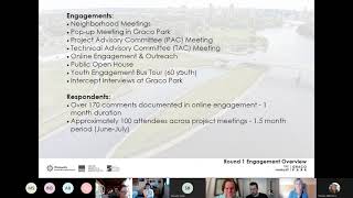
C
Actually,
on
that
technical
advisory
committee,
lots
of
online
engagement
and
outreach
the
age
of
a
public
virtual,
open
house,
a
big
youth
engagement,
push
with
the
bus
tour
with
over
60
youth
that
actually
drew
design
concepts
for
the
park
that
our
design
team
used.
As
as
like
very
deep
inspiration.
A
lot
of
the
ideas
are
showing
up
in
these
concepts
I'll
share
with
you,
and
then
we
did
some
intercept
interviews
at
graco.
C
So
you
know
just
a
little
bit
about
who
we
heard
from
we
always
you
know
in
in
a
project
in
the
city,
in
a
regional
park
which
this
is
considered,
will
set
typically
engagement
goals
and
for
this
project
it's
to
engage
with
people
that
reflect
the
residents
of
minneapolis
across
race
and
ethnicity,
gender
age,
also
economic
status.
There's
you
know
the
list
goes
on,
but
just
a
little
snapshot
of
some
of
those
demographics.
C
You
know
we're,
and
this
is
just
for
the
online
response.
We
didn't,
we
weren't
able
to
get
demographic
information,
for
you
know
every
single
respondent
or
participant,
but
you
know
pretty
good
representative
sample
we're
inching
toward
one
that
is
reflecting
our
city
of
minneapolis
and
then
a
little
bit
about
what
we
heard
and
so
keep
in
mind
that
we
developed
the
concepts
really
holding
a
lot
of
the.
You
know
these
drawings,
the
deeper
conversations
and
then
constantly
referring
back
to
this
list
of
like
what
do
people
really
want
on
the
site?
C
C
So
the
idea
with
this
building
is,
it
would
be
part
park
board
and
then
part
tenant.
That
would
help
with
park
activation
kind
of
reworking
the
idea
of
how
we
think
about
recreation
centers.
It
wouldn't
necessarily
be
a
recreation
center
in
its
truest
form,
but
more
of
a
community
gathering
space
meets
public
restrooms
needs
storage
for
operations
meet
some
other
uses.
That
would
be
tenants
that
would
help
us
again
keep
the
restrooms
open
longer
and
but
also
activate
that
part
and
bring
bring
more
life
to
the
park,
bring
more
eyes
to
the
park.
C
So
we
had
an
open
call
for
a
couple
of
months
and
had
some
great
great
possibilities
come
forward
and
are
kind
of
continuing
down
the
path.
I
think
in
our
next
stage
of
engagement,
we'll
share
more
details
around
the
building
design
process,
but
these
are
some
of
the
things
we
heard
around.
What
folks
would
like
to
see
in
a
park
board
building
on
the
site,
and
so
here
we
go
without
further
ado,
so
I'm
gonna
share
three
concepts
with
you.
C
Then
I'm
gonna,
I
think,
we'll
just
run
through
the
concepts
and
then
I
think
I'll
come
back.
We
can
have
a
discussion
about
them
and
then
we'll
move
on
and
talk
about
the
intersection
specifically.
Does
that
sound
okay?
I
should
also
do
a
time
check
here.
How
much
I
know
I'm!
This
is
a
very
focused
agenda.
I
liked
the
way
you
phrased
that
so
how
much
time
should
I
plan
on
here.
B
C
No
worries:
hey,
okay,
so
concept
one-
and
this
is
the
you
know.
This
is
the
we're
working
almost
like
a
master
plan,
scale
you'll
even
see
some
of
the
items
are
highlighted
in
orange,
noting
that
this
will
be
something
that
would
happen
in
the
future.
We
don't
currently
have
funding
for
a
vendor
or
like
a
concessions
entity
on
the
site,
but
that
is
something
that
we
heard
a
lot
about
an
interest
in
so
kind
of
holding
that
in
these
designs,
so
I'll
just
work.
C
We've
also
got.
This
is
probably
the
most
densely
activated
or
programmed
concept,
so
volleyball
courts,
dog
park,
of
course,
with
storm
water
elements
throughout
this.
This
concept
also
shows
a
some
kind
of
artful
splash
pad
water
feature,
and
then
probably
maybe
most
relevant
to
this
group
is
that
the
east
bank
trail
connection
in
all
of
them
would
be
coming
across
plymouth.
But
here
we
also
have
a
secondary
or
potentially
primary
route,
which
would
be
an
underpass
going
under
plymouth.
C
C
so
like
interesting
kind
of
nuances
to
what
an
underpass
might
look
like,
but
that
would
feed
people
to
boom
island
where
there's
a
boat
launch
and
sort
of
a
bridge
over
the
marina
so
for
pedestrians.
This
would
work
for
cyclists.
That
might
be
a
little
wonky
until
we're
able
to
make
improvements
at
boom
island
again,
there's
no
improvements
to
boom
island
in
this
project.
C
At
this
time,
so
another
thing
to
note:
in
all
the
drawings,
the
dash
line
represents
the
flood
barrier,
which
is
the
100
year
flood
barrier.
I
think
that
hasn't
reached
those
proportions
since,
like
the
1960s
I
mean
who
knows
with
our
current
climate
fluctuations,
but
you
know
that's
just
something:
that's
an
interesting
feature
of
each
of
these
concepts.
C
We
also
you
know
at
the
park
board,
I'm
sure
you're,
all
aware
of
our
trail
system.
Sometimes
our
we
have
shared
use
paths
where
bikes
and
pads
are
together.
In
this
concept,
we
really
we're
trying
to
split
those
modes.
So
this
through
line
of
east
bank
trail,
where
cyclists
and
maybe
peds
you
know,
pedestrians
could
walk
along
more
of
a
plaza
with
benches,
trying
to
separate
out
those
modes
whenever
possible,
having
multiple
ways
through
the
park,
promenade
and
then
finally,
a
bridge
out
to
the
island
with
a
viewing
platform.
C
We
really
heard
from
folks
that
they're
really
interested
in
just
maintaining
the
island
as
habitat,
so
we
actually
don't
show
a
trail
network
in
any
of
the
concepts
and
really
just
holding
on
to
this
idea
of
that.
It's
really
important
to
have
spaces
in
our
system
that
are
primarily
geared
for
habitat,
so
there'd
be
a
viewing
platform,
but
not
a
trail.
I
think
I
haven't
mentioned
yet
just
open
green
space,
again
lots
of
that
at
boom,
but
a
nice
sort
of
flexible
event
spaces,
and
so
there
you
are
there's
that's
concept:
one.
C
There
is
street
parking
on
sibley
and
all
the
concepts
you'll
also
see
this
future
building
site
for
graco.
That
I
mentioned,
we've
seen
a
couple
very
draft
renderings.
It
may
not
be
for
another
10
years,
but
there
might
potentially
be
a
six
story
tall
building
there
so
office
building,
so
just
something
to
keep
in
mind,
as
you
think
about
the
context
of
of
the
site,
so
maybe
I'll
just
pause
and
see
if
there's
any
questions.
C
E
C
Yeah
so
good
question,
maybe
I'll
I
can
roll
back
up.
I
actually
skipped
over
the
timeline,
so
we
are
not
even
I'd
say
you
know
we're
probably
closer
to
15
at
this
stage,
but
have
lots
of
different.
You
know,
we've
got
these
three
options
out
so
yeah.
That's
that's
now,
which
is
round
two
and
then
round.
Three
will
be
our
preferred
concept
and
that'll
get
us
closer
to
30.,
and
so
hopefully,
in
november
we
will
be
sharing
out
with
you.
C
B
Carrie,
thank
you
for
that.
If
you
want
to
continue
to
two
and
three
explanations,
but
I
would
like
to
say
that
after
you
talk
about
the
third
potential,
you
know
model,
there
might
be
some
questions
regarding
how
the
the
the
climate
crisis
that
we're
in
factored
in,
if
any
degree,
to
the
planning
that
your
you
and
your
colleagues
have
done.
I
know
you've
mentioned
planning
for
flooding
and
native
habitat
restoration.
B
C
All
right
so
concept,
two,
it
looks
like
it
looks
different
in
terms
of
this
one's
really
pulling
off
of
calling
it
the
minnesota
dock
concept.
So
it's
like
this
interesting
pier.
You
can
see
it's
not
a
bridge
out
to
the
island,
but
really
an
overlook,
giving
like,
and
also
creating
an
interesting
plaza,
extending
out
ninth,
which
is
an
interesting
street,
because
it
just
it
basically
ends
a
block
or
so
later
I
believe
in
a
parking
lot.
So
it's
like
this
little
interesting.
C
That's
that
gravel
landing,
and
I
think
that's
you
know-
that's
that's
for
the
most
part,
again
stormwater
treatment
throughout
as
another
definitely
kind
of
a
standard
both
required,
and
I
think,
climate,
resilient
management
technique
or
design
principle.
You
know
this.
One
also
shows
a
kayak
rental
in
storage
building
which
the
other
concepts
don't
focus
on,
but
we
are,
you
know.
C
We
know
that
this
is
a
popular
spot
already
to
boat,
and
so
how
do
we
create
access
for
folks
to
get
their
watercraft
down
potentially
to
do
storage,
maybe
moving
away
if
folks
are
familiar
with
lake
of
the
isles,
moving
away
from
like
an
open
boat
storage
area
and
doing
something
more
like
a
locker
system,
or
even
a
building
system
and
potentially
a
rental
space?
Also,
that's
actually
one
of
the
tenants
that
we're
talking
to
is
a
boat
kayak
and
canoe
education
and
rental
and
delivery
service.
C
Yeah,
I
love
that
question
yeah
great
question,
so
maybe
we
could
even
do
that
for
all
three
concepts,
but
certainly,
and
when
we
look
at
the
intersection
treatments
I
mean,
if
there's
big
big
events,
one
thought
is
that
folks
would
park
at
boom
island
parking
lot
across
on
foot
the
intersection
come
down
the
trail.
You
know
to
the
open,
green,
simply
parking.
You
know
there
is
again
street
parking
so
and
then
this
would
be
accessible
by
trucks,
maintenance
vehicles,
farmers,
market
trucks,
so
they're.
C
You
know
there
are
sort
of
those
those
considerations
for
loading
zone,
but
this
is
this
trail
right.
The
east
bank
trail
is
really
one
of
the
I
think,
most
significant
features
of
graco
park
and
just
as
a
through
space
for
cyclists
and
pedestrians,
people
rolling
and
walking
so
that
you
know,
I
think,
thinking
about
this
intersection,
even
though
also
the
street
grid
like
how
people
might
be
entering
off
coming
off
of
plymouth
crossing
sibling
coming
down,
not
everyone's
going
to
be
coming
from
boom.
C
This
bridge,
we
did
play
with
the
idea
of
there's
a
set
of
stairs
over
here.
Could
there
be
a
secondary
way
to
come
off
a
plymouth
right
into
the
heart
of
the
park
instead
of
coming
down
to
more
of
an
entry
plaza
so
that
that
fell
away
because
of
the
complications,
I
think
with
some
of
the
engineering
and
just
costs,
and
how
many
folks
might
actually
just
be
entering
the
park
off
of
this
side
of
plymouth
right
like
it's
really
difficult
to
skirt
across
plymouth.
C
F
C
Yep,
I
mean
it's
a
challenge
with
the
tunnels
or
underpasses
you
know,
and
the
safety
or
the
perception
of
safety.
Even
that's
something
that's
been
brought
up
a
lot,
and
so
how
do
we
design
a
tunnel
or
underpass
that
also
feels
inviting
and
that
people
are
really
coming
out
in
an
interesting
area
with
this
little
bridge
and
kind
of
gotta
turn
some
interesting
way.
You
know
you're
not
coming
out
into
the
city
street
network,
so
that
is
one
of
the
reasons
that
we
have
a
concept
like
this
with
no
underpass.
C
C
What's
I
don't
know
the
right
word,
but
I
think
this
one
is
a
is
feasible
in
that
you
know
if
there's
and
there's
a
lot
of
engineering,
that's
required
for
things
here
and
then
potentially
again
those
perceptions
of
safety,
there's
issues.
But
so
I
like
any
thoughts,
though
that's
something
I'd
love
to
hear
from
all
of
you
about,
though,
is
your
underpass
flash
tunnel
versus
intersection
and
it's
something
we've
gone
round
and
round.
B
C
All
right
cool,
so
concept:
three
here
we
go
we're
again
kind
of
bringing
the
buildings
closer
to
the
street,
but
still
in
the
park,
and
I
mean
the
idea
with
the
buildings
is
that
we're
activating
the
park?
This
again
has
a
strong
access,
but
breaking
the
grid
out
to
the
river,
but
not
a
bridge
seeding
along
the
shore.
C
So
just
picture,
you
know
different
sort
of
habitat
zones,
the
buildings
you
know
breaking
the
grid
and
the
small
areas
of
plaza
and
promenade.
You
know
two
two
very
distinct
ways
to
get
through
the
site
on
foot
or
rolling
and
again
those
same
intersection,
treatments
same
future
building
site
for
graco.
You
see
the
flood
barrier
here,
playing
with
different
elevations,
oh
and
then
public
art.
So
this
one's
got.
C
B
G
Sure
yeah
and
thanks
for
this
presentation,
very
informative
lots
of
thought
was
put
into
this
and
thanks
for
coming
to
our
group,
this
is
relatively
close
to
my
home
base
in
minneapolis
I
bicycle
over
here.
Pretty
often
I
live
near
the
university.
I
think
a
lot
of
students
also
still
live
in
this
neighborhood
too.
G
The
reason
why
I
say
that
is
because
the
bicycle
infrastructure
on
plymouth
and
eighth
half
northeast
is
already
it's
pretty
robust.
In
my
opinion,
I
mean
there
are
dedicated
bicycle
lanes
through
the
plymouth
8th
avenue
corridor
for
quite
a
while,
and
so
for
that
reason
it
has
me
thinking
it
makes
more
sense
to
have
at
great
crossing
for
the
trail,
because
then
you
can
easily
get
on
plymouth
or
eighth
and
navigate
the
on-street
bicycle
paths.
G
Usually
I
would
be
a
fan
of
something:
that's
not
that
great,
because
it
feels
more
streamlined.
Perhaps
could
reduce
commute
time.
Things
like
that,
but
the
at
great
crossing
at
the
intersection
of
plymouth
and
silby,
makes
me
think
that
then
you
could
connect.
You
don't
have
to
go
out
of
your
way
to
connect
to
the
already
existing
infrastructure.
To
me,
it
seems
more
cohesive
to
do
it
that
way
and
that's
my
opinion.
C
Great,
I
mean
that's
what
you
just
you
and
I
think
is
why
intersection
treatments
show
up
in
every
single
concept,
really
knowing
that
connecting
to
the
street
grid.
Here
is
really
an
important
part
of
this
project
scope
that
actually
wasn't
on
the
initial
project
scope-
and
it's
been
the
city
of
course,
like
has
been
a
really
important
thinking
partner
on
that
this
is
a
city-owned
street,
but
yeah
I'll
keep
taking
questions
and
we
can
move
on
to
intersection
I'll
talk
more
about
treatment.
There.
H
C
Oh,
I
love
that
point,
I'm
taking
notes.
I
mean
I
think,
that's
such
a
great
way
great
question
to
raise
and
thank
you
for
that.
The
the
concepts
for
the
intersection
treatments
that
we
are
looking
at
are
indeed
drawn
from
the
street
design,
guide
and
midnight
bike
manual
so
for
state
aid
roads
for
so
we'll
we'll
look
at
those
and
you'll
you'll
see
that
it's.
I
think
it
is
more
geared
toward
current
conditions
when
we
think
about
that
street
crossing.
H
C
A
H
C
C
There's
been
some
conversations
around
trying
to
push
to
see
if
this
might
be
a
pilot
project
for
thinking
about
raised
crossings
in
a
state-aid
road
situation.
So
there
there
have
been
some
internal
like
well
as
this.
Something
is
our
race
crossings
of
interest.
Is
this
something
worth
pursuing
and
that's
actually
a
question
for
all
of
you?
You
know
when
we
look
at
the
intersection
treatments,
we
could
go.
Look
at
those
really
quickly
just
to
have
a
little
more
context.
C
I
think
I
might
just
pause
because
it
feels
like
it's
coming
up
a
lot,
if
that's
all
right
with
everyone,
I'll
just
jump
to
these
and
we'll
come
back
to
the
concepts
with
this
in
mind.
So
again,
here
we
are
sibley
when
I
say,
or
rather
plymouth
to
eighth
it
is
a
city-owned
street.
It
is
a
state-aid
road,
so
high
volume
level
of
traffic
there
is
this
bridge
coming
across
the
river
with
pretty
you
know,
with
somewhat
of
a
slope,
people
are
coming
pretty
rapidly.
There
have,
as
you
mentioned,
there's
some
nice.
C
You
know
existing
bike
lanes
some
protections
with
those
bike
lanes.
This
idea
that,
like
providing
access
from
the
east
bank
trail
to
boom
island
and
graco
park,
is
for
us
the
most
significant
feature
of
this
intersection,
while
the
city
has
other
goals,
but
for
us
it's
really
focused
on
this
idea
of
calming
traffic
to
get
all
users
across
safely.
C
You
know
safety
island
is
something
these
might
be.
It
might
be
all
of
the
above
curb
extensions
safety
island
raised
crossing
since
I
know
you're
a
savvy
group.
I
assume
you're
aware
of
examples
in
our
community
of
each
of
these.
These
are
out
of
the
city
of
minneapolis
street
design
guide
which,
as
you
I'm
sure,
no
follow
the
transportation
action
plan,
and
then
we
also
have
mndot
bike
facility
design
manual,
which
includes
things
like
a
median
refuge
island,
unsignaled,
intersection,
protected
intersection,
curb
extensions.
C
So
there's
you
know
lots
of
different
potential
for
slowing
traffic
there's,
but
it
again
is
the
state
aid
road.
It
is
the
city
on
the
street
and
we
will
be
working
in
collaboration
with
the
city
and
state
aid,
road
standards
on
on
developing
a
design.
Those
conversations
really
have
just
begun,
but
the
city
is,
you
know,
really
excited
about
the
potential
of
east
bank
trail
connecting
up
to
the
city
network,
making
sure
this
is,
you
know
at
least
improving
the
crossing
in
collaboration.
B
C
So
that
means
that
everything
in
here
would
be
designed
and
built
with
the
understanding
that
it
would
flood
potentially
right,
and
that's
just
something
that
I
think
when
we
think
about
talk
about
resilient
design.
That
is
actually
a
reality
and
just
designing
for
flooding
is
one
way
of
thinking
about
blood
mitigation
or
just
resilient.
You
know
resilient
planning.
The
flood
barrier
itself
won't
actually
be
like
a
firm
wall.
C
I
think
maybe,
when
the
plaza
meets
a
certain
grade,
it
might
look
like
a
retaining
wall,
but
for
the
most
part
it
will
just
be
re-grading
at
the
site
which,
if
you
can
see
the
sun
of
topographic
lines
in
each
of
the
features
of
each
of
these
concepts
that
show
that
elevation
gaining
through
most
mostly
through
earth
moving.
So
it
won't.
Maybe
we
could
definitely
do
just
like
a
flood
wall
right,
but
the
we
we
want
to
also
create
a
park
in
a
space,
that's
okay
to
flood.
So
hopefully
that
answers
your
question.
E
E
C
That's
great
I'll
I'll.
Take
that
as
a
comment-
and
I
I
know-
certainly
we
will
have
lighting
and
the
extent
of
the
lighting
is
not
determined
yet
at
this
stage,
but
there
will
be
lighting
one
of
the
things
you
know
with
with
trails
by
the
river
and
especially
being
adjacent
to
halls,
island
thinking
about
the
habitat
ramifications
of
of
lighting
in
a
wild
space.
So
we'll
be
balancing
you
know
it's
going
to
be
a
balancing
act,
certainly
with
how
much
lighting
on
the
site
and
what
type
of
lighting.
C
B
D
Sure
yeah
thanks
for
coming
carrie,
I
I
also
used
to
live
over
here
and
so
spent
a
lot
of
time
at
boom.
Island
and
graco
watched
it
kind
of
develop
from
sort
of
nothing
almost
so
it's
cool
to
see
these.
I
was
just
wondering
you
were
talking
about
connecting
with
the
city
like
what
group
you've
connected
with
or
like
who
you're
working
with
at
the
just
from.
C
D
I'll
just
throw
out
my
my
personal
preference.
Obviously
matthew
can
dig
into
more
detail
from
like
the
city's
official
review,
but
I
I
think
some
sort
of
median-
and
I
don't
know
if
there's
been
talk
about
like
a
rectangular
rectangular
rapid,
flash
beacon,
at
least
for
like
the
trail
connecting
side.
I
think
at
this
location,
in
particular
with
the
amount
of
people
and
just
the
type
of
traffic
with
traffic
coming
from
both
sides
at
once.
That
can
be
a
really
effective
design.
So
that
was
great.
C
H
C
H
F
Aaron
yeah,
I
I
was
just
gonna
say
about
that
intersection.
Obviously
I
know
you're
changing
the
intersection
that
initial
look
at.
It
is
frightening
to
me.
We
we
talk
about
design
vehicles
a
lot
here,
so
here's
my
design
vehicle
is
like
a
bicycle
or
a
stroller
with
like
a
child
seat
on
the
back
and
then
another
child
trying
to
bicycle
across
the
street
with
me.
So
you
know
as
it's
being
designed.
F
I
think
that's
why
I
guess
I
leaned
so
much
towards
the
underpass,
because
it
just
isn't
risky
from
a
like
will.
I
get
run
over
standpoint
and
I
I
really
appreciate
the
the
designs
that
you're
bringing
forward,
and
you
know
I
trust
everybody
that
you
you're
talking
with
on
the
tax.
So
you
know
I'm
sure
you'll
come
up
with
something
good,
but
that
just
to
explain.
I
guess
why
I
was
you
know
pretty
pretty
heavily
favoring
that
non-grade
crossing
option.
C
F
B
I'll
just
jump
in
here
and
then
we're
going
to
go
to
austin.
I
just
want
to
echo
okay
and
we'll
we'll
go
to
austin
and
then
julia
and
I'll
just
be
real,
quick.
I
just
wanna.
I
concur
with
aaron
and
in
partly
because
I
think
that
you
know
you
have
a
flow
in
a
park
along
the
river
and
then
and
then
there's
this
barrier,
and
then
you
have
to
shift
to
going
through
the
traffic
and
and
and
and
undergo
what
aaron
was
talking
about.
B
G
I
I
agree,
I
think,
in
normal
circumstances
I'm
definitely
pro
underpass.
I
just
am
thinking
of
climate
change
and
and
what
happens
when
the
river
permanently
rises,
because
I
think
that
is
something
that
we're
looking
at
and
the
reason
why
I
say
this,
I
just
it's
so
funny.
I
was
just
in
chicago,
visiting
family
and
and
near
lake
michigan
along
lakeshore
drive,
there's
tons
of
underpasses
that
let
pedestrians
access,
lake
michigan
and
several
are
permanently
flooded,
because
lake
michigan
is
rising.
Now
I
realize
it's
apples
and
oranges.
G
You
know-
and
I
I
think
it's
a
really
hard
thing
to
broach,
because
no
one
can
really
predict
the
future
here
and
we
can
try
to
be
climate
resilient
and
it
sounds
like
you
all
put
a
lot
of
work
into
that
for
me
as
just
a
regular
civilian
though
it's
always
in
the
back
of
my
head
is
like.
What's
this
going
to
look
like,
you
know,
post
climate
when
when
the
river
is
permanently
higher,
so
that's
the
reason
why
I
bring
that
up.
C
A
C
B
H
I
actually
have
a
couple
of
questions
or
comments,
so
I
christopher,
let
me
know
when,
if
you
want
to
go
to
somebody
else,
but
I
would
echo
the
concerns
about
flooding,
that
austin
raids,
that's
something
that
that
seems
like
an
increasing
risk
and
along
with
that.
What
christopher
said
about
the
hundred
year
floodplain
and
I'm
wondering
if
you
or
this
contractor,
ran
numbers
for
like
a
thousand
year
flood.
H
I
know
that
that's
something
that
we're
seeing
in
other
parts
of
the
world
and
I
don't
see
any
reason
to
think
that
that's
outside
of
what
we
can
expect,
since
this
is
a
spiraling
and
intensifying
issue
rather
than
linear.
And
let
me
just
look
at
my
notes
that
one
I
would
really
love
to
know
sort
of
where
your,
where
you
and
your
team
are
at
in
terms
of
adjusting
really
for
those
those
large
scale,
events
and
and
being
erring
on.
H
Besides
caution
and
I'm
also
curious
the
context
of
what
drains
here,
what
would
drain
over
land
if
the
sewers
or
stormwater
sewers
weren't
able
to
handle
the
volume
that
we,
if
we
got
you
know
if
we
saw
sort
of
those
long
duration,
storms
staying
in
place
like
we've
seen
this
year
in
a
couple
of
places
around
the
us.
What
what
places
you
know
how
much
of
northeast
is
draining
through
here
and
how
the
permeability
of
the
roadways
might
differ
now
from
what
it
was
in
the
1960s.
H
H
C
Thanks
so
I'll
start
with,
I
think
the
one
that
I
well
the
one
question
around
flooding
that
I
do
have
a
clear
answer
for
so
I
know
that
they
did
modeling
for
several
different
iterations
of
flooding,
and
I
believe
that
beyond
the
100
year
flood
you
know
level
was
modeled.
I
can
certainly
follow
up
with
you
by
email
or
send
information.
Maybe
I
don't
know
chris
or
melis.
C
You
know
what
what
you
guys
think
what's
the
best
way
to
follow
up
on
that,
but
I
can
definitely
get
you
more
information
around
what
was
found
and
what
was
modeled
the
100
year.
Flood
flood
was
modeled
for
this
particular
design
concept
because,
as
part
of
this
settlement,
graco
graco
wanted
us
to
agree
to
this
idea
of
a
hundred
year,
flood
barrier
in
the
site,
and
I
neglected
to
mention
that
earlier
in
the
settlement
kind
of
montage-
it's
not
as
usually
as
like
central
to
the
conversation.
C
So
I
I
love,
though,
that
you
all
are
thinking
about
climate
and
flooding
so
astutely.
So
this
was
actually.
This
stipulation
really
came
out
of
the
graco
settlement
and
that
they
wanted
to
model
and
build
a
barrier
for
the
100
year,
flood
event
and
so
we're
integrating
it
into
the
entire
site
because
they're
doing
it
here
so
it's
like
become
now
becomes
a
design
move.
I
don't
know
that
this
park
that
we'd
be
raising
the
elevation
to
the
100
year
flood
barrier
without
that
kind
of
push
from
graco
for
their
site.
C
So
it's
it's
interesting.
I
mean
we
again
like
flooding
is
not
in
itself
a
bad
thing,
especially
when
we
think
about
parkland
like
we
can
be
a
more
resilient
landscape
for
flatability,
and
so
just
that's
like
very,
very,
very
high
level
kind
of
philosophical
take
and
then
that's
why
the
100
year
was
focused
on
for
the
designs.
C
The
training
yeah
basically
yeah.
Okay,
thank
you
so
that
I
do
not
have
information
on
right
now,
that'll
be
well.
How
about
that
be
part
of
my
follow-up
I'll
see
what
what
kind
of
research
we
do
have
on
that.
I
know
that
there's
been
a
district
analysis,
so
potential
for
bringing
in
pipe
shed
from
other
parts
of
the
neighborhood
to
do
more
of
a
district's
treatment
in
the
park
and
that
there
was
not
enough
oops.
C
There
was
not
enough
runoff
onto
this
site
or
in
the
pipe
shed
leading
to
this
site
to
warrant
a
district
stormwater
approach,
so
that
that
leads
me
to
believe
that,
like
the
actual
kind
of
pipe
shed
district,
stormwater
piece,
it's
like
not
that
significant
in
terms
of
what
this
parkland
is
receiving
or
passing
through
this
park.
But
again
I
I
can
follow
up
and
kind
of
verify
or
see
if
I
can
dig
into
more
information
and
share
that
question
with
our
with
the
engineering
team.
C
B
C
Perfect
thanks
great
plan.
Okay,
so
one
of
the
things
we've
been
working
to
do
with
engaging
with
both
native
community
local
community
and
also
tribal
leadership
in
projects
is
trying
to
work
across
projects
more
effectively
at
the
park
board,
and
so
we
are
doing
regular
communications
and
updates
to
the
tippo's
and
so
graco
got
you
know.
The
last
couple
of
updates
has
been
included
in
those
more
leadership
level
updates
to
all
of
our
regional
typos,
and
then
we
also
have
done
some
pointed
outreach
to
you
know
indigenous
partners.
C
We
part
of
the
youth
tour
that
I
mentioned.
We
had
youth
from
magazine,
do
a
canoe
trip
to
the
site
and
talk
through
the
design.
Also
as
part
of
that
larger
youth
tour.
There
was
indigenous
groups
represented
so
along
with
other,
like
groups
from
saint
paul
and
regional,
mostly
bipac,
youth,
so
really
interesting,
kind
of
design
ideas
coming
out
of
those
conversations
but-
and
I
think
one
of
the
core
elements
with
the
building
and
the
site
design
that
we're
finding
is.
C
This
idea
of
interpretation
is
a
really
important
theme,
whether
it's
the
industrial
or
whether
it's
the
indigenous
and
so,
as
we
start
to
drill
down
into
what
those
are
working
more
closely
with
native
community
is
the
plan
you
know
we're
not
I'm
not
going
to
tell
anyone's
story
right
without
working
with
them,
and
so
that
has
sort
of
that's
emerging
very
much.
So
I'm
like
what
are
the
next
steps?
That's
what
we've
done
to
date.
C
So
we
have
again
like
across
projects,
had
some
larger
land
back
conversations
and
for
this
this
site
was
not
identified
as
a
specific,
like
site
of
significance
they're
in
terms
of
like
the
cultural
historical.
There
are
other
sites
in
the
park
system
that
are
emerging
as
significant,
so
that
are
more
likely
in
those
conversations
and
like
more
targeted
so
again
across
projects.
This
one
has
not
been
elevated
to
that
level
of
like
how
do
we
talk
about
land
back
also,
just
a
side
note.
C
E
B
B
I
think
the
city
needs
more
benches
and
and
places
to
rest
your
feet,
or
at
least
I
do
when
I'm
out
for
a
walk
and
to
take
in
the
scene,
and
that
I
think
is,
is
a
great,
a
great
addition
or
a
great
proposal,
and
what
I
don't
like
is
for
whatever
it's
worth
is
concept
two.
I
just
get
the
feeling
that
it's
pv
plaza
light,
there's
so
much
building
and
trucks,
and
it's
just
it's
too
much.
I
think
my
inclination
is
for
three.
B
H
A
H
I,
when
you
were
mentioning
the
the
sort
of
implicit
activation
of
the
space
through
tenants,
I
was
really
excited
and
thought
it
might
mean
that
there
would
be
housing
associated
with
this
and
disappointed
when
it
turned
out
it
wasn't
it's
so
it
sounds
like
a
great
step
if
there's
a
way
of
incorporating
housing
really
making
it
higher
density
and,
and
that
would
help
address
some
of
what
barb
was
raising,
which
is
something
that
also
limits
how
I
use
this
area.
So
that's
my
comment.