►
Description
On April 29th, 2020, the City of Minneapolis held an online open house to get feedback on the draft Transportation Action Plan. City staff presented for about 30 minutes and then answered questions from the audience. For more information about the plan go to http://go.minneapolismn.gov
A
Good
evening,
everybody
and
welcome
to
our
second
online
open
house
for
the
city
of
Minneapolis,
this
draft
transportation
action
plan
happy
to
have
you
all
with
us
here
tonight,
just
before
we
begin
a
bit
of
housekeeping
for
anybody
in
the
audience.
If
you
experience
technical
issues
with
the
broadcast,
you
can
use
the
comment
form
that's
either
on
the
side
or
bottom
of
your
screen
to
request
help.
We
have
staff
on
hand,
monitoring
these
comments
and
they'll
do
their
best
to
resolve
any
comments
or
issues
you
have.
A
If
they
do
persist,
we
will
have
a
recording
of
this
meeting
available
on
our
website
after
meeting
we'll
also
be
hosting
one
additional
online
open
house
on
Thursday
May
14th
from
11:00
to
12:30
and
previous
online
open
houses
and
unanswered
questions
will
be
posted
on
our
website.
Our
website
is:
go
minneapolis,
go
dot,
minneapolis,
MN,
gov,
fully
interactive
and
we
also
have
an
email
address:
go
mpls
at
Minneapolis,
MN
gov.
If
you
are
unable
to
use
the
comment
form,
they
will
not
be
able
to
respond
to
emails
during
this
broadcast.
A
We
appreciate
your
patience
and
understanding
and
look
forward
to
hearing
any
of
your
feedback
so
to
begin,
I'd
like
to
first
recognize
my
colleagues
who
are
on
this
online
open
house
with
me.
Most
of
them
will
be
introducing
themselves
as
they
take
over
for
part
of
the
presentation,
but
three
are
providing
behind
the
scenes,
support
and
I'd
like
to
acknowledge
them,
and
thank
that
here:
Chris
Kartheiser,
Amy,
Morgan
and
Cristian
Zimmerman.
A
My
name
is
Kathleen
mail,
I'm,
a
transportation
planning
manager
in
the
city
of
Minneapolis,
Public,
Works,
expert,
ation
planning
and
programming
division
and
I'm
gonna
lead
us
through
the
first
part
of
this
open
house
and
then
we'll
hear
from
directly
from
the
topic,
leads
on
more
specific
pieces
contained
in
the
transportation
action
plan
and
then
we'll
have
a
Q&A
next
slide.
Please.
A
This
is
an
overview
of
what
we're
going
to
be
covering
this
evening,
a
little
bit
of
context
for
the
transportation
action
plan.
What
our
timeline
and
engagement
has
looked
like
to
date,
how
the
plan
is
structured,
top
highlights
the
plan,
then
we'll
pass
it
off
to
my
colleagues
for
topic,
specific
strategies,
a
quick
slide
on
joining
how
to
join
the
conversation
and
we'll
open
it
up
for
Q&A,
with
the
remaining
time
that
we
have
together
next
slide.
One
piece
here
on
the
impacts
of
covin
19
to
our
planning
process
for
the
draft
transportation
action
plan.
A
All
of
our
engagement
has
transferred
online.
Our
website
was
designed
to
be
very
interactive
with
many
ways
to
comment,
so
that
continues
to
be
available
to
comment
direct
on
our
strategies
and
actions
or
network
maps,
and
we
have
extended
our
comment
period.
Our
initial
end
date
by
a
month
to
be
open
through
May
22nd,
and
we
will
evaluate
that
as.
A
The
next
slide,
please
so
to
go
through
a
bit
context.
Next
slide
the
transportation
action
plan
comes
out
of
really
Minneapolis
2040,
which
is
the
city
Minneapolis
comprehensive
plan.
Looking
out
20
years,
transportation
was
one
of
11
topics
covered
with
that
planning
effort,
and
it
had.
There
was
24
transportation
related
policies
within
that
document.
This
is
adopted
city
policy.
A
Safety,
which
is
really
in
line
with
our
vision,
zero
efforts
and
really
preserving
life
on
our
streets
and
reducing
impacts
of
traffic
crashes
equity.
Is
that
we're
working
toward
equitable
outcomes
for
all
people
through
our
transportation
network,
providing
mobility
and
access
and
mobility,
our
multimodal
options,
increasing
in
the
safety
ability
and
comfort
for
those
walking
biking
and
taking
transit
in
our
city?
So
Minneapolis
2040
really
defines
what
we're
trying
to
accomplish
with
this
plan
and
the
transportation
action
plan.
A
A
22%
of
the
land
area
in
the
city
is
our
public
right
of
way
and
that's
land
held
in
trust
for
the
public
good
and
through
this
action
plan,
we're
really
looking
to
use
streets
and
and
highlight
them
as
places
for
people
recognizing
them
as
an
invaluable
asset
that
we
can
leverage
our
broader
citywide
outcomes.
We
can
reflect
our
values
and
we
can
create
a
more
sustainable,
equitable,
safe
and
prosperous
city
through
thoughtfully
planning,
building
and
constructing
operating
on
our
streets.
A
The
transformation
action
plan
is
a
ten
year
action
plan,
so,
whereas
in
Minneapolis
2040
is
20
years,
this
is
a
ten-year
horizon.
We
are
not
fiscally
constrained
in
this
plan
that
was
intentional
to
be
able
to
set
the
vision,
it's
ambitious,
but
realistic,
and
this
allows
us
the
opportunity
you
know,
should
different
funding
opportunities
that
were
able
to
leverage
or
national
or
regional
partnerships,
we're
really
putting
out
there
what
we
want
to
see
and
not
being
constrained
by
our
current
budget.
A
We
recognize
that
this
plan
in
order
to
accomplish
it,
takes
partnership
and,
to
that
end,
when
you
look
through
on
our
website
or
download
the
plan,
every
action
is
either
identified
as
a
do
or
a
support
action.
The
ones
that
are
identified
as
due
are
those
where
public
works
would
take
the
lead
on
accomplishing
those
items.
Support
recognizes
that
many
things
we
do
are
supporting
others
who
are
working
within
the
public
right-of-way,
be
them
other
jurisdictional
partners
like
Hennepin
County
or
the
state
of
Minnesota
Department
of
Transportation
and
in
working
with
others
toward
common
goals.
A
There
are
four
key
city
policies
that
are
impacting
and
how
this
entire
plan
approach
of
this
entire
plan,
so
Minneapolis
2040,
which
I
just
spoke
about
our
Complete
Streets
policy,
which
identifies
a
modal
hierarchy.
Here
you
can
see
the
three
colored
bars
people
walking
and
rolling
first
than
those
taking
transit
and
biking
followed
by
those
in
a
private
vehicle.
So
that
framework
you
can
see
percolates
throughout
the
entire
plan,
vision,
zero,
which
is
our
commitment
to
ooh,
ending
traffic
fatalities
and
life-altering
injuries
on
our
streets
due
to
traffic
crashes.
A
Within
ten
years
from
when
we
adopted
that
policy,
which
is
2017
so
that
goes
to
2027
and
then
finally,
our
climate
action
plan,
which
puts
out
a
bold
plan
to
reduce
greenhouse
gas
emissions
by
80%
by
2050
from
a
2006
baseline.
So
many
of
the
actions
and
strategies
within
our
plan
are
pinned
to
that
as
well,
and
look
toward
helping
achieve
the
goals
set
out
in
the
climate
action
plan.
A
Next
slide,
please,
there
have
been
two
related
planning
efforts
that
Public
Works
has
undertaken
recently
our
vision,
zero
action
plan,
which
was
adopted
last
December
and
our
Americans
with
Disabilities
Act
transition
plan
for
Public
Works,
which
was
adopted
in
February
of
2020.
We
did
engagement,
simultaneous
or
at
different
times
throughout
the
past
year,
Plus
on
all
three
of
these
planning
efforts
and
we've
listened
to
the
feedback
that
people
have
given
through
those
different
efforts
and
incorporated
as
appropriate
into
the
different
planning
documents.
A
So
you'll
see
we're
not
trying
to
repeat
ourselves
within
these
plans,
but
we
do
try
to
elevate
and
support
and
leverage
off
of
these
plans,
one
with
the
other
to
accomplish
citywide
goals,
and
you
can
see
that
specifically
with
different
actions
that
call
out
the
vision.
Zero
is
you
know
some
of
the
actions
within
the
vision,
zero
action
plan
or,
more
broadly,
a
lot
of
the
strategies
and
actions
within
our
walking
topic,
really
supporting
the
work
of
the
Americans
with
Disabilities
Act
transition
plan.
Next
slide,
please.
A
So
to
give
a
brief
summary
of
where
we
have
been
with
our
planning
efforts
and
engagement
next
slide.
Please
again,
this
is
rooted
with
Minneapolis
2040
and
that
engagement
spanned
three
years
parts
of
three
years
between
2016
and
2018,
and
the
city
received
a
lot
of
comments
about
transportation.
During
that
planning
process
we
have
read
all
of
them.
We
have
summarized
them,
and
that
in
quote,
is
part
of
what
provides
the
foundation
for
the
plan
we
have
on
our
goal.
A
Minneapolis
website
on
our
get
involved
page,
you
can
see
a
summary
of
those
in
our
phase.
1
summary,
we
talked
about
the
main
themes
that
we
received
during
that
engagement,
so
that
very
much
informed
the
plan
and
then
moving
to
the
transportation
action
plan.
Our
first
phase
was
in
summer
of
2018,
some
light-touch
engage
ment
around
different
city
events,
open
streets,
farmers,
markets,
different
festivals,
and
that
is
also
summarized
in
our
phase.
A
1
engagement,
summary
phase
2,
which
was
really
the
bulk
of
our
engagement
to
date,
has
was
the
first
half
of
2019,
where
we
had
a
whole
variety
of
ways
we
engaged
with
folks
conservatively.
We
estimate
we
connected
with
over
3,000
people
more
than
4,000
comments.
We
partnered
with
our
neighborhood
and
community
relations
department
on
community
dialogues
with
different
cultural
communities
that
are
sometimes
hard
to
connect
with.
A
So
we
did
several
of
those
summaries
of
that
effort
are
on
our
website,
as
well
as
where
you
can
find
within
our
draft
transportation
action
plan,
different
strategies
and
actions
that
reflect
the
concerns
and
ideas
of
those
communities.
We
also
partnered
with
six
different
neighborhood
groups,
artists,
community
organizations,
to
help
extend
our
engagement
approach
and
that
information
is
also
summarized
in
our
phase
2
engagement,
summary,
which
brings
us
to
this
last
phase,
which
is
happening
now
through
May
22nd,
where
we
are
collecting
thoughts
and
input
feedback
on
the
draft
that
we
have
released
next
slide.
A
A
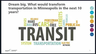
This
slide
just
shows
one
question:
we
asked
we
asked
us
that
a
lot
of
our
different
events,
not
all
of
them.
This
represents
the
answers
of
over
330
people
and
we
asked
dream
big.
What
would
transform
transportation
Minneapolis
in
the
next
10
years
and
transit
was
such
a
huge,
huge
response
that
we
received
from
this
question,
but
overall
of
our
engagement
and
so
you'll
see
that
reflected
in
our
work
and
just
wanted
to
share.
You
know
a
visual
of
some
of
the
things
that
we
heard
a
lot
about.
A
A
So
we
again
just
to
summarize
what
I
said
at
the
beginning,
the
comic
pier
is
open
through
the
May
22nd.
We
have
one
additional
online
open
house
that
there
is
a
tool
box
available
on
our
website.
If
folks
would
like
to
host
their
own
community
or
neighborhood
virtual
gathering
to
discuss
the
transportation
action
plan,
so
there's
a
short
presentation,
a
form
you
can
fill
out
that
you
can
use
and
we're
planning
on
bringing
this
stitute
City
Council
for
adoption
later
this
year.
A
Next
slide,
please,
our
website
is
really
interactive
and
I
just
want
to
share
a
couple
slides
of
it.
Screenshots
of
the
website.
In
case
you
haven't
taken
a
look
yet,
but
so
you
can
dive
right
into
the
different
topic
areas
next
slide.
Please,
and
for
each
topic
area
you
can
see
there's
the
pink
boxes
are
like
for
transit,
there's
six
strategies
and
each
where
it
says,
see
also
strategies.
We
a
lot
of
this
work,
really
it
doesn't
fit
neatly
in
one
category.
A
So,
while
the
plan
is
broken
up
into
different
topic
areas,
there
we're
not
repeating
in
different
strategies,
so
street
operations
strategy
could
apply
equally
to
transit
as
it
does
street
operations.
So
those
are
noted
as
well
and
then
at
the
bottom
there
you
can
see,
there's
maps
which,
if
you
go
to
the
next
slide,
please
this
is
when
you
click
on
an
actual
strategy.
A
A
You
can
comment
right
there
on
the
particular
strategy
or
action,
and
you
can
see
the
different
goals
that
each
action
supports,
as
well
as
a
little
difficulty,
either
low,
medium
or
high,
and
this
is
just
to
share
a
bit
about
what
the
you
know
a
bit
of
transparency
about
when
things
are
how
difficult
it
might
be,
each
action
next
slide.
Please
you.
A
A
This
looking
to
reshape
the
transportation
system
to
address
climate
change
using
technology,
feed,
design
and
mobility
options
to
aggressively
reduce
greenhouse
gas
emissions
caused
by
vehicles.
The
safety
goal
is
to
reach
vision,
zero
right
by
prioritizing
safety
for
all
people
and
eliminating
traffic
fatalities
and
severe
injuries
by
2027.
A
Equity,
build
and
operate
in
a
transportation
system
that
contributes
to
equitable.
Now
the
options
that
move
people
and
goods
through
reliable
connections
retain
top
talent
and
grow
Minneapolis
as
the
economic
engine
of
the
region,
mobility
embrace
and
enable
innovation
and
advances
and
transportation
to
increase
and
improve
mobility
and
access
options
for
all,
and
finally,
active
partnerships
create
and
seize
opportunities
to
achieve
shared
goals
and
responsibilities
through
partnering
and
leveraging
in
funding
opportunities
with
national
and
regional
partners
and
others
who
invest
in
the
city.
A
So
all
of
our
actions
speak
to
one
or
more
of
those
goals,
and
these
are
the
different
topic
areas.
So
there
are
seven
the
shorthand
walking
bicycling,
transit
technology,
Freight
Street
operations
and
design
and
we'll
spend
some
times
on
each
of
these.
The
latter
half
of
the
presentation
is
diving
into
more
specifically
these
topic
areas
next
slide.
Please.
A
There
are
four
networks
that
are
put
forth
in
this
plan.
Our
first
is
the
pedestrian
priority
network,
the
second
all
ages
and
abilities,
which
is
our
bike
way
network,
and
then
we
have
a
map
of
transit,
priority
projects
and,
finally,
our
truck
route
network.
This
is
the
existing
truck
route
Network.
We
do
have
an
early
action
item
to
update
this
network,
and
our
topic,
Lee's
will
will
dig
into
those
for
a
little
bit
more
when
they
take
over
next
slide.
A
A
This
plan
for
transit
freight
and
Technology.
These
are
all
areas
that
we
haven't
as
a
city.
With
our
past
planning
efforts,
access
Minneapolis
spent
as
much
time
or
effort
on
so
wanted
to
highlight
that,
as
it
relates
to
this
third
bullet
here,
to
realize
a
city,
light
and
transit
vision,
which
really
makes
taking
transit
more
attractive
and
an
affordable
option
for
more
people.
A
Nicole
and
micro
mobility
network,
Michael,
Freight,
Micro
mobility
and
green
infrastructure
adopt
a
strong
cup
site
management
policies,
so
managing
that
curb
that
space
right
by
those
I'd
Walker
Boulevard,
prioritizing
space
for
people
and
valuing
those
competing
needs
for
curbs,
is
in
highly
used
areas
and
then,
finally,
implementing
the
network
of
mobility
hubs,
which
are
places
where
people
can
connect
to
multiple
shared
transportation
options.
Things
like.
A
Using
the
transit
system
as
the
backbone
and
there's
our
shared
cars,
so
we
have
piloted
that
work
in
2019
and
looking
to
continue
implementing
that
work
as
we
move
forward.
So
with
that
I
will
hand
it
over
next
slide.
Please
to
the
next
section,
which
is
topic
specific
strategies
to
all
of
our
topic,
leads
who'll
each
introduce
themselves
and
go
into
more
details,
so
Thank
You,
Kelsey.
B
Hello:
everyone,
my
name,
is
Kelsey
Foat
I'm
here
to
introduce
the
walking
topic.
This
topic
focuses
on
strategies
and
actions
to
make
walking
a
more
comfortable,
welcoming
and
viable
option
for
getting
around
the
walking
topic
has
eight
strategies.
Each
of
those
strategies
has
several
actions
included
within
it.
One
of
these
strategies
is
to
prioritize
improvements
for
pedestrians,
on
a
set
of
streets
throughout
the
city,
called
the
pedestrian
priority
network
or
PPN.
For
short,
this
draft
network
is
roughly
a
560
miles
of
sidewalk
or
280
miles
of
streets.
B
Streets
not
on
the
pedestrian
prior
network
are
still
great
places
to
walk,
but
the
pedestrian
prey
network
provides
guidance
on
where
to
focus
pedestrian
improvements
first
to
serve
the
most
people
and
provide
access
to
these
key
destinations.
In
addition
to
establishing
a
pedestrian
priority
network,
the
draft
plan
has
seven
other
strategies,
including
prayer
safety
and
visibility.
Improvements
at
Street
crossings
for
pedestrians,
enhancing
street
lighting,
ensuring
access
to
the
sidewalk
network,
year-round,
improving
connections
across
freeways
highways
to
rivers
and
roads
and
providing
high
quality
spaces
for
pedestrians
in
the
public
realm.
C
This
is
intended
to
help
make
sure
people
of
all
ages
and
abilities
and
backgrounds
feel
very
comfortable,
bicycling,
scooting
and
rolling
and
walking
in
Minneapolis.
It
is
made
up
of
existing
bike
way
routes
and
136
miles
of
new
or
upgraded
bike
ways,
including
79
miles
of
protected
bike
lanes,
48
miles
of
new
neighborhood,
greenways
and
9
miles
of
new
trails.
We
are
interested
in
getting
your
specific
thoughts
on
this
network.
You
can
check
out
the
map
and
share
your
feedback
by
clicking
on
the
network
map.
You
can
comment
on
it
there.
C
A
few
additional
specific
highlights
of
this
topic:
our
focus
on
safe
intersections,
overcoming
barriers
and
connecting
people
to
regional
destinations,
maintaining
the
triple-a
network,
including
bike
WA
detours
and
winter
maintenance,
designing
bike
ways
that
reflect
the
community
and
provide
additional
benefits
most
notably,
including
making
it
easier
for
people
across
the
street
and
a
variety
of
other
important
strategies
and
actions
that
complement
the
bike
ways
themselves,
including
parking
education,
encouragement
and
measurement,
as
all
I
have
at
this
time,
I
look
forward
to
hearing
your
thoughts.
Thank
you.
D
Hi
there
I'm
Becca,
Hughes
and
I
love.
The
transit
topic
of
the
tap
transit
is
a
critical
component
of
the
tap
building
up
the
Minneapolis
23
comp
plan,
which
calls
for
more
growth
in
both
population
and
jobs
focused
along
in
your
transit
corridors
and
as
Kathleen
ended
earlier.
We
heard
a
lot
about
transit
turn
engagement
efforts
for
the
tap,
and
this
is
really
one
of
the
first
times
that
the
city
has
established
a
vision
for
transit
at
Minneapolis,
with
a
clear
set
of
priorities,
goals
and
actions,
and
by
partnering
with
Metro
Transit.
D
We
can
plan
for
and
invest
in
transit
priority
projects
that
aim
to
improve
the
coverage,
speed
and
reliability
of
transit.
We
know
that
means
it
must
be
convenient,
reliable,
affordable,
frequent
and
safe
in
order
to
reduce
sov
trips.
Our
goal
is
to
increase
transcripts
to
one
in
four
trips
or
25
percent
by
2030,
so
there
are
a
total
of
six
transit
strategies
and
45
action.
Steps
they're
currently
in
the
draft
planned
outlined
here
are
the
draft
strategy
is
expanding.
Access
to
high
frequency
transit
corridors,
citywide
kathleen
remarked
on
this
earlier.
D
This
reference
is
the
75%
of
our
zones
within
a
five-minute
walk
of
high
frequency,
transit
and
90%
within
a
10-minute
walk,
and
we
feel
these
are
achievable
through
new
and
growing
markets.
Neighborhood
based
transit
improve
crosstown
service,
as
well
as
coordination
with
Metro
transit
on
network
next,
in
other
initiatives,
increasing
the
speed
and
reliability
of
transit.
This
is
where
we
see
implementation
and
actions
related
to
bus,
only
lanes,
transit
advantages
like
TSP,
kyu-jong,
styling,
dynamic
lanes
and
others
increased
transit
resources
and
managing
capital
investments.
D
This
is
really
about
developing
capital
programs
to
help
us
deliver
our
transit
projects
throughout
the
city
and
working
with
partners
and
cpad
among
others.
First,
a
new
high
impact
transit
projects
include
our
BRT
network,
our
LRT
network,
as
well
as
quarters
that
we
have
studied
extensively
in
the
past,
including
the
Midtown
corridor,
West
Broadway,
as
well
as
Nicollet
and
Soto
expanding
multimodal
access
to
transit.
D
This
is
really
where
technology
mobility
hubs
come
into
play,
as
well
as
the
first
last
mile
connection,
as
well
as
filling
the
sidewalk
gaps
and
other
actions
and,
lastly,
supporting
efforts
to
ensure
transit
is
safe,
comfortable
and
affordable.
This
really
relies
in
supporting
current
and
future
after
transit
efforts.
I'll
close
here.
E
E
This
topic
outlines
how
we
will
most
thoughtfully
integrate
technology
to
help
us
meet
our
goals
when
it
comes
to
shared
fleets
such
as
shared
bikes
and
scooters,
and
any
other
future
shared
models
that
we
see
in
our
city,
electric
vehicles,
which
includes
buses,
scooters,
ebikes
and
vehicle
cars
connected
infrastructure
and
connected
people,
which
is
the
ability
for
vehicles,
people
and
traffic
systems
to
talk
to
one
another
and
then,
lastly,
the
automation
of
transportation.
So
now
I
will
jump
right
into
our
strategy.
E
Our
second
strategy
is
something
we
heard
a
lot
about
through
engagement
of
the
transportation
action
plan
in
the
past
couple
of
years,
and
that's
to
remove
barriers
such
as
lack
of
smart
phone
bank
account
or
driver's
license
to
shared
mobility
like
scooter
share
and
bike
share.
Our
third
strategy
is
working
with
private
and
public
partners
to
implement,
implement
innovative,
an
ambitious
pilots
such
as
mobility
hubs,
which
are
physical
places
where
people
can
connect
to
with
low-carbon
modes,
including
transit.
E
Our
first
strategy
is
around
data
and
the
collection
and
sharing
of
data
from
private
companies
to
help
inform
future
planning
and
investments,
building
a
culture
of
advanced
modes
through
education
and
awareness
of
how
they
work
in
order
to
realize
their
full
potential
invent
and
benefit
is
our
fifth
strategy,
while
our
more
lower
strategy
and
priority.
A
of
this
topic
is
turning
courage
and
support
adoption
of
electric
vehicles
and,
finally,
our
last
strategy
is
building
internal
capacity
within
the
city
to
advance
these
new
initiatives
and
get
the
REA
balance
between
regulations,
support
and
support
for
innovation.
F
Hello,
my
name
is
Alexander
Cato
I'm,
the
freight
topic
lead.
This
is
our
most
robust
fellate
freight
planning
effort
today,
and
it
really
comes
at
a
critical
time,
since
it
will
help
guide
how
Goods
move
through
and
within
our
city,
there's
eight
strategies
and
a
plethora
of
actions
associated
with
that.
F
Number
two
is
on
improving
the
safety
and
efficiency
of
freight
movements,
an
action
associated
with
that
talks
about
implementing
a
traffic
county
program.
So
we
can
get
better
more
accurate
data
on
freight
vehicle
movements
and
within
our
city
in
terms
of
their
routing
and
the
and
the
volume
of
those
trips
that
are
occurring.
Number
three
is
in
is
regards
to
Fred
operators
and
it
be
updating
the
truck
route
map
which
Kathleen
alluded
to
earlier
in
the
presentation.
F
Number
four
is
on
transitioning
to
zero
emission
vehicle
fleets
are
providing
more
of
the
electric
charging
stations
for
those
Freight
vehicles
to
recharge
their
batteries.
Number
five
is
on
implementing
dynamic
loading
zone,
so
that's
rethinking
our
curb
space
and
providing
a
dynamic
pricing
system
as
well
as
flexibilities,
so
that
we
allow
the
most
important
use
of
the
curb
at
the
most
important
time
of
the.
A
F
Number
six
and
seven
go
hand-in-hand,
and
it's
focused
on
working
with
the
private
sector
and
academic
institutions
to
pilot
and
implement
innovative
solutions.
I'm
sure
many
of
you
have
heard
about
drones,
sidewalk,
robots
and
things
like
that,
and
obviously
there's
a
lot
of
concern,
but
also
a
lot
of
an
interest
in
those
technologies
and
as
we
move
forward
with
exploring
those
and
other
technologies,
we
want
to
make
sure
that
they're
implemented
in
a
way
aligns
with
our
city
values
and
is
not
destructive,
but
actually
contributes
to
the
freight
movements
within
our
city.
F
G
Hello,
my
name
is
Katie
white
and
I
will
lead
us
through
the
street
operations
section
of
the
tap
Street
operations
isn't
modal.
We
don't
focus
in
the
section
on
any
one
way
of
getting
around
town,
but
this
and
the
next
section,
which
is
Street
design,
start
pulling
all
the
content
that
my
colleagues
were
just
talking
about,
pulling
it
together
and
talk
about
how
each
of
them
loads
will,
in
turn
interact
with
each
other
and
and
how
we
approach
the
sharing
that
happens
in
the
public
right
of
way
between
them
loads.
G
Some
of
the
content
and
the
street
operations
plan
is
project
based,
but
also
similar
to
the
previous
sections.
Some
of
the
content
in
the
street
operations
section
is
philosophical
or
how
the
city
will
be
approaching
its
discussions
with
our
partner
agencies
and
other
people
who
operate
within
the
city,
and
so
that's
something
to
keep
in
mind.
As
you
read
through
the
section.
Not
only
are
the
strategies,
but
also
the
actions
that
underlie
them.
There
are
nine
Street
operation
sections
to
go
through,
so
they
have
two
slides
here.
G
The
first
is
to
update
the
Complete
Streets
policy.
Kathleen
provided
an
overview
of
the
Complete
Streets
policy
at
the
top
of
this
presentation
and
it's
barely
been
foundational.
It's
been
really
helpful
within
public
works
and
without
to
define
our
priorities,
which
are
to
make
sure
that
it's
a
safe
environment
for
people
walking
and
rolling.
Most
of
all
the
Complete
Streets
policy.
We
don't
want
to
rewrite
it
from
scratch,
but
we
do
need
to
update
it.
It
omitted
some
key
portions,
some
key
parts
of
the
city
operations
in
its
first
iteration.
G
We
need
to
incorporate
Freight
as
Alexander
was
just
talking
about.
We
need
to
talk
about
green
infrastructure,
which
is
something
that
was
omitted
the
first
time
around,
and
we
also
need
to
talk
about
micro
mobility,
which
has
no
was
talking
about
earlier
as
well.
So
it's
not
a
wholesale
rewriting,
but
we
want
to
let
people
know
that,
since
this
has
been
a
visible
policy,
we
are
looking
to
update
it.
The
second
action
here
is
to
eliminate
traffic
related
deaths
and
serious
injuries.
G
As
kathleen
was
mentioning
earlier,
we
have
done
significant
work
on
vision,
zero
and
research
in
creating
an
action
plan
there.
So
this
conversation
highlights
those
activities
that
the
city
will
be
undertaking.
Third,
is
to
plan
for
people
walking
biking
using
micro,
mobility
or
transit
through
street
design.
This
talks
a
little
bit
about
how
we
allocate
space
across
the
city.
Fourth,
is
to
promote,
educate
and
encourage
walking
biking
and
using
transit.
This
is
pretty
straightforward.
G
G
So
much
v
is
there's
quite
a
lot
of
content
here
that
I,
encourage
folks
to
take
a
look
at
is
to
pricing
the
curb
to
encourage
walking
biking
and
using
transit.
When
we
talk
about
the
curb
we're
looking
at
both
sides
of
the
curb
that's
a
street
side
as
Alexander
was
talking
about,
you
know
the
loading
and
deliveries,
but
also
the
sidewalk
side.
G
There's
a
lot
of
competing
demands
along
the
curb
and
we're
looking
to
engage
in
that
conversation
see
what
the
future
of
that
topic
looks
like
six
is
to
induce
regional
mode
shift
through
capital
projects.
This
includes
capital
projects
that
the
city
is
leading
and
then
also
involvement
that
the
city
has
on
capital
projects
that
other
agencies
might
be
leading
in
the
city
limits.
For
example,
the
county
or
MnDOT
seven
is
to
align
traffic
signal
operations
with
the
Complete
Streets
policy,
and
this
is
this
all
modes
related.
G
This
is
how
pedestrians
interact
with
traffic
signals,
also
potentially
putting
bicycle
signals:
bicycle
traffic
signals
on
bicycle
routes
and
also
reducing
encouraging
the
reduction
of
speed
of
vehicles
through
traffic
signal.
Timing,
8
is
to
coordinate
with
agency
partners
on
projects
within
the
city.
This
is
something
that
is
always
ongoing,
but
we
want
to
reiterate
the
city's
position
on
this
work,
so
they
know
where
we
are
coming
from
when
we
engage
in
conversation
with
them
and
nine
is
to
manage
Street
D
detours
in
line
with
the
Complete
Streets
policy.
G
Part
of
that
is
the
routing
of
detours,
but
also
you
know,
the
city
has
seen
so
much
development
and
has
that
development
has
necessitated
detours
and
so
how?
What
is
the
interaction
between
development
and
the
right-of-way
that
they're
using
and
that's
a
really
interesting
conversation
that
people
are
aware
of
and
engaged
in
thanks?
So
much.
H
Hi
everyone,
my
name,
is
Ethan
folly
and
I
am
the
lead
on
the
design
section
of
the
Transportation
Action
Plan.
This
section,
as
Katie
alluded
to,
is
again
sort
of
bringing
things
together
and
how
does
how
do
the
different
modes
and
ways
that
people
get
around
and
we
talked
about
earlier
in
the
plan?
How
do
they
come
together
in
the
physical
space
of
a
street?
We
only
have
so
much
Street
space.
So
how
do
we
fit
the
goals
of
the
city
into
that
space?
To
help
inform
that
work?
H
We
are
developing
currently
a
street
design
guide
that
will
be
out
later
this
year.
It's
really
a
technical
document
that
brings
together
the
policies
and
actions
you
see
in
this
plan
down
into
what
does
it
look
like
on
different
types
of
Street
that
will
be
interactive
and
available
online
and
will
be
a
resource
both
for
our
internal
technical
staff,
but
also
for
community
members
you're
going
to
see
some
of
other
things
in
here
we're
linked
back
to
some
of
the
other
topics.
H
A
case
in
point
is
the
second
strategy
here
around
fostering
vibrant
public
spaces
for
street
life.
I'm
going
to
see
a
lot
of
connection
to
the
the
walking
topic,
things
like
the
plaza
program,
I'll
live
here,
so
I
think
you're
going
to
be
interested
in
some
of
the
ideas
that
are
in
the
actions
in
this
section.
In
particular,
number
three
includes
both
Carbon
Reduction
design
elements,
but
also
some
other
environmental
related
things,
they're
really
technical
in
nature.
H
And
how
are
we
reducing
our
environmental
impacts
from
how
we
build
streets
and
maintain
and
operate
them
as
well?
Greening
the
streets
is
both
about
having
an
attractive
tree,
canopy
and
other
things
that
make
it
a
great
place
to
to
be,
but
also
about
expanding
our
work
on
stormwater
management,
so
that
we're
reducing
runoff
and
we're
able
to
that
into
our
streams
and
also
that
we're
able
to
deal
with
flooding,
which
is
becoming
a
bigger
issue.
H
We
then
we
have
some
things
about
making
sure
we're
bringing
in
transit
and
into
our
streets
as
well,
and
the
final
strategy
here
is
really
a
very
technical
one
about
how
we're
interacting
with
other
agencies
that
impact
our
ability
to
design
our
streets.
So
that
wraps
up
our
topics
in
the
section
and
that
will
transition
to
Q&A
thanks.
So
much.
A
So,
thank
you
all.
That
was
an
overview
of
the
55
different
strategies
that
are
in
the
draft
transportation
action
plan.
Those
55
strategies
contain
over
280
individual
actions.
So
again,
I
encourage
you
to
dig
into
the
plan
and
give
us
detailed
comments
back
on
what
you
see
so
next
slide.
Please
just
a
summary
of
ways
to
engage.
So
there
are
there
that
top-line
I'm,
sorry
should
say:
there's
one
more
additional
open
house,
and
that
is
on
our
website.
A
I
I
I
want
to
thank
you
all
again
for
joining
us
and
also
think
this
phenomenal
team,
who
has
put
together
this
draft
transportation
action
plan
and
these
online
engagement
opportunities
for
all
of
you
to
to
read
and
comment
and
provide
your
input
and
thoughts
with
us
tonight
and
in
the
other
engagement
opportunities
that
we
are
offering.
So
thank
you
for
that.
We
look
forward
to
hearing
from
you.
We
will
try
to
get
to
as
many
of
your
questions
as
we
can
during
our
time
here
this
evening,
so
we
have
scheduled
until
about
8:30
tonight.
I
So
any
questions
that
remain
in
the
chat
board
that
we
do
not
get
to.
We
will
answer
in
writing
and
post
onto
our
website.
Once
we
get
those
responses
pulled
together,
we
did
that
after
the
first
online
open
house-
and
you
can
find
those
responses
posted
on
our
website
right
now.
If
you
do
not
get
your
question
put
up
onto
the
chat
board
tonight,
the
best
way
to
get
your
question
put
before
us
is
through
an
email
to
our
our
project,
email,
which
is
up
on
the
slide
right
now.
I
A
A
We've
we've
worked
with
website
management
already
in
the
last
month
and
a
half
to
issue
permits
for
pickup
zones
for
businesses
to
help
those
businesses
thrive
and
survive
during
this
time.
For
people
to
do
quick,
pick
up
our
curbside
takeout
for
either
food
or
other
items
for
businesses
that
have
been
open,
we've
also
together
with
partnering,
with
the
park
board,
we've
created
or
are
in
the
process
of
creating
you
know,
jointly
with
the
park
board,
40
miles
to
stay
healthy
streets.
A
So
these
are
spaces
that
are
more
open
to
those
biking
and
walking
and
have
more
space
limiting
that
through
traffic
residential
access.
Only
to
make
it
so
that
people
are
able
to
be
outside
in
safe
ways
that
are
they're
able
to
socially
distance.
So,
like
everyone
during
this
time,
we
are
in
a
learning
mode
and
a
processing
mode.
We
are.
We
have
the
foundation
of
this
draft
plan
to
really
pull
on
now
and
lean
on.
I
C
You
for
the
question,
so
we
don't
specifically
note
in
the
tap
which
streets
will
be
protected,
bike
lanes
or
neighborhood
greenways.
We
wanted
to
maintain
a
little
bit
of
flexibility
as
we
design
the
streets
moving
forward,
but
one
thing
that
I
will
note
is,
if
you,
if
you
know
of
a
street,
that's
on
the
Triple
A
network
and
it
just
it
currently
feels
really
busy,
and
you
may
not
feel
super
comfortable
biking
in
that
Street
right
next
to
cars.
It's
a
good
bet.
C
The
vestry
would
be
a
protected
bike
lane
and
then,
conversely,
if
there's
some
streets
that
are
on
the
triple-a
network
that
are
currently
pretty
calm
but
may
cross,
some
busy
streets
may
connect
to
schools.
Things
like
that.
It's
also
a
good
bet
that
that
would
be
a
neighborhood
Greenway.
So
what
kind
of
the
vision
kind
of
depends
on
on
how
busy
it
is
from
a
traffic
perspective?
I
D
That
is
correct.
Thanks
for
the
question,
Jenny,
that's
correct.
The
plan
doesn't
currently
address
the
streetcar
in
the
transit
section.
This
was
also
intentional.
We
basically
did
not
identify
specific
modes,
but
what
we
did
is
we
identified
specific
corridors
that
we
felt
could
benefit
by
having
improved
transit,
whether
that's
enhanced
or
improved
buses
or
other
types
of
mechanisms
to
support
transit
service.
You
know
the
three
focus
areas
specifically
I
mentioned:
West
Broadway,
Nicollet
Central.
D
I
A
You
sure
fair
question:
there
are
a
couple
reasons
why
we
asked
for
this
information.
We
know
in
a
public
comment
process,
it's
important
that
those
who
comment
do
so
in
a
thoughtful
manner
and
are
accountable
to
their
comments.
So
when
we
ask
for
this
information,
it's
a
bit
more
similar
to
coming
to
a
public
event
and
speaking
or
providing
written
comments.
A
So
that's
a
big
part
of
it.
It
also
helps
us
understand
if
we
are
getting
multiple
comments
from
the
same
person
we're
having
or
hearing
the
same
comments
from
many
different
people.
So
that's
the
reasons
why
we
ask
for
it
and
then,
in
terms
a
zip
code,
why
we
asked,
for
that
is
just
understanding
where
we're
hearing
from
people
and
if
we're
hearing
from
people
in
all
parts
of
the
city
or
or
if
there
are
areas
where
we're
not
reaching.
As
many
folks.
I
G
Thanks
Jenny
and
thanks
for
this
question,
when
we
look
at
both
sides
of
the
curve,
you
know
we
want
to
well,
first
of
all,
we'll
be
developing
a
curbside
policy
in
the
near
future
and
that's
a
product
that
is
going
to
come
out
as
a
result
of
this
transportation
action
plan.
But
what
we're
looking
at
is
for
the
use
of
the
curb
to
reflect
the
city's
values
and
you've
seen
that
in
the
discussion
about
that,
for
example,
the
mode
share
splits
and
how
we're
prioritizing
people
walking
biking
or
taking
transit.
G
So
if
we
were
to
say
that
you
know
the
entire
curb
for
an
entire
city,
block
will
be
reserved
for
car
share
or
vehicle
loading
that
wouldn't
be
reflective
of
the
city's
values,
and
so
we're
looking
to
create
something
that's
slightly
more
uniform
than
what
we
have
today.
Something
that's
easy
to
understand.
You
know
Complete
Streets
policy.
Has
that
really
great
graphic?
That
Kathleen
showed
that's
really
easy
to
understand
and
I.
Don't
know
if
it
looks
like
a
graphic
for
the
curbside
policy
it
might,
but
we're
looking
to
have
something.
G
I
B
So
we
have
a
strategy
on
winter
walking
and
rolling.
There's
a
number
of
actions
outlined
in
that
strategy.
They
overall
they're
building
off
of
some
earlier
work
that
we
did
called
the
winter
meeting
study
or
in
thing
that
was
finished
up
in
2018.
So
we
took
some
of
those
findings
and
really
dug
into
them
a
bit
more
on
the
actions
that
you
see
in
the
plan
for
the
transportation
action
plan,
they
focus
on
expanding
awareness
of
the
really
the
importance
of
clearing
snow
and
ice.
B
Just
communicating
how
important
it
is
to
have
those
clear
pathways
for
people
to
get
around
in
the
winter,
clearly
defining
the
roles
and
responsibilities
under
the
current
ordinance.
That
ordinance
requires
that
property
owners
take
a
lot
of
that
responsibility
and
clearing
and
keeping
their
sidewalks
clear
if
it
people
to
get
around
and
communicating
for
how
to
find
help
for
those
who
are
unable
to
clear
their
sidewalks
and
there's
quite
a
few
in
there
on
streamlining
the
inspection
process
and
the
enforcement
process
for
how
the
city
checks
in
on
how
we're
doing
with
sidewalk
clearance.
C
C
Bikeways
are
generally
very
good
for
winter
riding,
I
guess,
respectively
and
then
the
other
thing
is
winter
winter
maintenance
of
this
new
idea
of
the
neighborhood
greenways
or
low
volume
residential
routes.
We
want
to
explore
how
we
can
match
the
level
of
service
of
protected
bikeways,
which
is
currently
a
level
of
service
to
clear
those
bike
ways
within
24
hours.
So
that's
another
important
action
in
town.
I
D
Thanks
Jenny
and
thanks
for
the
question,
that's
a
great
question.
You
know
one
of
the
strategies
that
we
also
use
and
implement
throughout
the
city.
Arkansas
called
cue
jumps
and
those
are
things
that
we
typically
use
approximate
to
intersections.
Also
inline
stops
you
you
see
that
infrastructure
with
buses
stopping
in
hélène
that
provides
transit
advantage
for
Metro
transit
buses
and
you're,
seeing
that
more
frequently
on
high
frequency
transit
routes
as
well
as
BRT
routes
and,
last
but
not
least,
dynamic
lanes,
which
are
basically
a
modified
version
of
a
bus
lane.
D
We
have
those
currently
operating
on
Hennepin
Avenue
in
south
Minneapolis,
where
we
have
AM
peak
bus
lanes
that
are
dedicated
in
the
morning.
Curbside
they're
used
for
parking
outside
of
those
dedicated
hours
and
then,
conversely,
in
the
p.m.
peak,
we
have
bus
lanes
that
operate
where
parking
is
not
permitted.
However,
Perkins
Road
throughout
the
day,
so
those
are
lanes,
dynamic,
lanes
or
considered
trains
and
advantages
as
they
provide
transit
advantages
for
transit
to
be
able
to
operate
in
their
own
lane
during
the
times
that
they
need
it.
Most.
I
A
A
If
you're
talking
about
uber
or
lyft,
that's
even
more
complicated
I
mean
for
you.
It
would
be
if
you're
popping
in
an
uber
or
lyft.
That
would
be
a
multi
occupant
trip
for
you.
Uber
lyft
driver,
however,
on
the
tail
ends
of
that
or
would
be
in
a
single
occupant
vehicle
trip,
so
those
are
not
considered
transit.
Those
would
be
considered
either
single
or
multiple
occupancy
vehicle
trips.
I
Great.
Thank
you.
This
next
question
is
going
to
go
to
Kelsey
Kelsey.
How
does
this
video
Minneapolis
walking
routes
for
youth
map
fit
into
the
transportation
action
plan?
Well,
infrastructure
improvements
continue
to
be
prioritized
on
it
or
do
the
all
ages
and
abilities
network
and
the
pedestrian
priority
and
tap
replace
it.
You.
B
Know
that's
a
really
good
question.
I,
don't
think
I
have
a
immediate
answer
for
it.
I
know
that
you're
talking
about
how
to
use
that
walking
routes
for
youth
map
in
the
future,
I
can
tell
you
that
the
the
pedestrian
priority
network
did
use
some
of
the
same
criteria
that
went
into
that
walking
routes
for
use
in
generating
the
pedestrian
routes,
namely,
schools
was
one
of
the
the
destinations
that
was
a
big
influence
and
how
that
map
was
generated.
There's
a
lot
of
overlap
in
the
two
maps.
B
I
C
C
If
I
recall
correctly,
because
I
was
before
my
time,
the
existing
bicycle
boulevard
map
was
an
important
part
of
those
routes
and
we
used
that
network
as
a
really
important
starting
point
for
the
triple-a
Network
as
well.
I
know
they
don't
align
perfectly,
but
that
was
definitely
something
that
we
considered
very
much
in
the
development
of
our
triple-a
network.
I
A
I
C
So
I'll
address
this
by
talking
again
about
neighborhood
greenways
I,
can't
name
specific
streets
that
will
specifically
be
car
free,
but
one
of
the
ways
that
will
we'll
get
to
that
answer
is
implementing
neighborhood,
greenways
and
I'm,
realizing
that
we
haven't
really
defined
neighborhood
greenways
in
this
conversation
today,
so
I
just
want
to
do
that.
Really
quick,
so
neighborhood
greenways
are
similar
to
what
we
call
bike
boulevards
now
in
that
bill,
there'll
be
low
volume,
residential
streets
that
are
converted
to
be
much
more
friendly
to
people
walking
and
biking.
C
We
want
to
optimize
travel
for
pedestrians
and
bicyclists
by
either
eliminating
or
significantly
reducing
motor
vehicle
use,
and
so
that's
kind
of
how
it's
tied
in
to
this
question
is
we
there
will
be
about
50
miles
of
streets
that
we
look
at
converting
to
these
neighborhood
greenways
and
not
all
of
them
will
be
car
free
streets.
Some
of
them
may
retain
cars
and
just
make
it
more
pleasant
for
people
to
walk
and
bike.
H
Have
thoughts,
mister
I
would
just
add
that
in
the
design
section
the
plan
and
the
foster
vibrant
public
spaces
strategy
number
two.
We
do
have
that
we'll
be
exploring
these
opportunities
for
car
free
streets.
As
part
of
that,
we
do
plan
to
have
some
information
around
how
we
would
do
that
in
the
street.
Design
guide
will
be
coming
out
this
later
this
year.
I
D
Thanks,
that's
actually
a
great
question,
the
wok
shutters
that
are
basically
a
calculation
or
benchmark
to
understand
where
we
are
and
where
we
want
to
be
relative
to
transit.
You
know
the
city's
priority
is
to
provide
and
make
high
frequency
transit,
accessible
and
proximate
to
more
residents
in
the
city.
It
certainly
requires
a
partnership
with
Metro
Transit,
but
we
are
also
looking
to
establish
our
own
capital
programs
to
help
advance
our
city
goals
and
priorities
relative
to
transit.
D
I
C
That
that
is
a
good
question.
I
think
we
have
we
protected
bikeways
will
look
very
different
I'm
across
the
city.
One
way
I
would
recommend
finding
and
finding
out.
The
answer
to
that
question
is
to
go
on
a
bike
ride
in
Minneapolis
right
now.
We
have
a
lot
of
examples
of
protective
bike
ways
in
Minneapolis
in
all
parts
of
the
city,
and
so
it
really
does
range
from
the
standard.
I
Thank
You
Matthew
next
question
is
going
to
go
to
Ethan
Ethan.
This
question
is:
is
a
multi-part
question
but
I'm
going
to
hone
in
on
the
last
part
of
it,
which
is
essentially
asking
if
alternative
bicycle
types,
especially
those
that
are
larger
in
nature
and
have
large
turning
radii,
are
somehow
being
accommodated
in
our
designs
on
the
street
and
in
our
street
design
guide.
H
C
Ethan
I
will
add
on
I
I
just
love
this
question
as
well.
This
is
really
important
as
a
lot
of
new
vehicle
types
emerged,
new
bicycle
vehicle
types
emerged:
I
myself,
bought
a
an
electric
assist
bike
last
year
and
and
just
thinking
about
how
we
incorporate
those
into
our
street
design
is
really
important
and
then
on
the
specifics
of
street
design.
C
I
have
definitely
raised
this
issue
and
a
lot
of
our
planners
do
when
we're
considering
bike
ways
and
and
just
thinking
about
how,
how
our
trails
make
curb
or
or
how
wide
some
of
our
bridge
crossing
our
bridges
might
be,
and
sometimes
there's
curves
on
the
on
the
bridges
like
5th
Street
across
I-35,
just
trying
to
make
sure
that
they
they're
14
feet
instead
of
10
feet
or
8
feet,
so
that
somebody
with
a
trailer
could
make
that
turn.
So
it's
definitely
something
we
think
about,
and
we
need
to.
I
Thanks
guys,
next
question
is
going
to
Katie
Katie,
how
feasible,
in
Street
operations,
section
5.7
congestion
pricing.
This
is
a
crucial
element
of
the
tap
to
increase
equity,
reduce
emissions
and
improve
if
parking
is
employer-provided
or
cheap,
as
it
often
is.
There
are
a
few
barriers
to
driving.
This
strategy
should
be
coupled
with
strategy
5,
which
is
about
extending
kerb
pricing,
so
that
that
it
is
financially
disadvantages
to
drive.
We
need
to
make
it
cheaper
to
take
transit
or
bike
or
walk
than
to
drive
in
order
to
meet
our
2040
climate
and
safety
goals.
I
G
What
I'll
start
with
this
I
am
where
the
question
started
with,
how
feasible
is
it
and
you
know,
you're
looking
at
action,
5.7
and
Kathleen
was
saying,
you
know
there
are
do
and
their
support,
and
so
here
this
one
says
do
and
what
is
the
verb
that
we
put
in
here.
We
put
study
I,
agree
that
congestion
pricing
is
a
pretty
big
issue
and
it's
it's
huge
and
it
would
be
a
game-changer
and
right
now
we're
committed
to
studying
when
we
chose
these
verbs.
We
wanted
them
to
be.
G
You
know
realistic
with
within
10-year
time
frame
of
the
plan,
and
so
we
are
committing
to
studying
the
issue.
But
then,
if
you
look
all
the
way
over
on
the
right-hand
side
of
the
page,
it
says
difficulty
level
high,
and
that
is
us
saying.
Yes,
we
know
it's
a
big
deal.
Yes,
we
know
it's
important
and
yes,
we
know
it's
going
to
be
a
challenge.
G
You
know
New
York
City
struggled
with
this
several
years
ago
and
was
shot
down
by
the
state
legislature,
and
so
we
know
it's
not
just
a
technical
issue
of
how
do
you
physically
create
a
congestion
pricing
system
in
the
city
of
Minneapolis,
but
there's
also
policy
considerations
and
other
stakeholders
beyond
those
within
Minneapolis
Public
Works,
who
are
going
to
need
need
to
be
brought
along
as
we
study
this.
So
that's
the
level
of
commitment,
that's
provided
here
and
as
to
the
rest
of
the
comments
about
pricing
in
general.
G
Yes,
all
of
strategy
5
is
about
pricing
and
I'll,
just
echo
what
I
said
earlier
and
say
that
we
want
our
pricing
structures
to
reflect
our
values.
You
know,
oh,
is
it
a
year
or
two
ago,
meter
rates
in
downtown
are
now
slightly
variable
and
slightly
higher
in
certain
areas
in
order
to
promote
turnover
vehicles,
instead
of
just
parking
once
all
day
for
a
pretty
cheap
rate,
and
so
I
think
that
that's
true
for
all
the
actions
here
and
in
section
5,
we
want
pricing
of
the
curb
to
promote
our
values.
G
I
Thank
You
Katie
next
question
is
going
to
Matthew
another
question
about
bicycling
for
bicycling
number:
three:
are
we
going
to
have
a
citywide
policy
regarding
greenways
so
that
every
decision
such
as
diversion
placement
or
parking
removal,
won't
have
to
be
litigated
in
council
or
public
works
meetings?
I'm
worried
that
every
action
in
this
topic
is
going
to
be
a
block
by
block
fight
with
local
residents.
Unless
there
is
a
citywide
policy.
C
Alright
I,
thank
you
for
this
question
as
well.
One
thing
I'll
note
is
that
tap
will
be
adopted.
City
policy
when
it
is
adopted
by
City
Council
in
the
near
future,
but
I
will
say
that
the
details
will
be
important
for
this.
One
in
effective,
Public,
Engagement
I
think
will
be
critical,
because
this
is
such
a
new
concept.
The
idea
of
greenways
and
then
the
nice
thing
about
the
vision
of
neighborhood
greenways,
is
that
they
are
flexible
by
design.
H
I
H
H
H
I
G
I
guess
I
want
to
nitpick
this
just
a
little
bit
and
call
out
the
language
that
we're
using
in
action
3.2,
because
this
is
a
really
important
issue,
as
I'm
sure
the
person
who
suggested
this
comment
knows
about
it
says
to
discontinue
the
use
of
vehicle
level
service,
except
where
necessary,
to
meet
funding,
legislative
or
other
jurisdictional
requirements.
So
the
intent
is
to
not
use
vehicle
level
of
service
in
city
projects
as
a
determining
factor.
I
think
that
ello
s
is
a
useful
thing
to
know
about
a
project
I,
don't
think
it
should
be.
G
And
so
that's
recognizing
that
many
apples
as
a
partner
with
other
people
with
other
priorities,
and
so
we
need
to
be
respectful
of
that
and
work
with
our
partners
again
in
the
document
on
the
page.
It's
written.
This
is
a
medium
level
of
difficulty,
because
it's
something
that
we
can
do
internally
on
our
projects
at
the
city,
but
for
external
projects.
It
is
it's
just
that
it's
just
a
different
value
system
that
we
need
to
work
with.
I
A
Good
question
on
this
plan:
I,
the
short
answer
is
very
little.
We,
we
are
not
identifying
in
this
plan
revenue
sources
or
how
to
fund
all
this,
and,
as
I
mentioned
at
the
beginning
of
the
presentation,
this
intentionally
is
not
fiscally
constrained.
The
role
of
this
plan
and
in
this
effort
is
to
put
forth
a
vision
of
what
our
streets
can
and
we
hope
will
be,
and
we
can
plan
for
and
will
be
within
10
years
and
then
well
as
it
gets
adopted
into
city
policy
by
the
City
Council.
A
It
is,
then,
the
role
of
the
policymakers,
the
mayor
and
the
City
Council
members
to
figure
out
and
allocate
funds
and
budgets
and
whatnot,
which
is
their
job.
So
our
role
in
this
plan
is
to
put
forth
the
vision
and
the
plan,
and
then
the
budget
piece
is
separate
intentionally.
Thanks
for
the
question.
I
H
Certainly
the
the
Cova
19
emergency
has
shaken
a
lot
of
things
up,
and
we
have
to
think
about
that.
Overall,
we
have
seen
statewide
in
Minnesota
that,
while
traffic
crashes
are
down
significantly
since
the
emergency
order
was
put
in
place,
traffic
fatalities
are
all
significantly
and
that
is
almost
exclusively
due
to
increase,
speeding
and
aggressive
driving.
So
we
recognized
and
have
recognized
in
this
plan,
as
well
as
in
the
vision,
zero
action
plan,
the
importance
of
lowering
speeds
to
support
safety
on
streets.
That
remains
a
key
strategy
and
approach
in
both
plans.
H
We
we
see
that,
maybe
even
more
so
coming
to
the
fourth
of
how
important
that
is,
because
slower
speeds
make
it
safer
for
everyone
they
make
it
crash
less
likely
and
they
make
it
less
likely
to
be
deadly.
So
as
we,
we
have
recently
lower
speed
limits
and
we're
on
city-owned
streets,
all
city-owned
streets
in
the
city,
we're
in
the
process
of
implementing
that
this
summer
and
into
the
fall
and
we're
also
going
to
be.
H
So
that's
reflected
in
this
plan
and
others
we're
gonna,
be
narrowing
Street's
up
more
in
our
street
design
guide
to
support
safety,
we'll
be
introducing
other
elements
into
the
kind
of
typical
designs
we're
looking
at
to
control
speed.
We
are
also
looking
at
updating
our
traffic
calming
procedures
and
other
things
to
support
traffic
calming
improvements
citywide.
H
So
those
are
all
things
that
we're
going
to
be
continuing
to
move
forward
with
the
vision,
zero
action
plan,
which
is
separate
from
the
transportation
action
plan,
as
Kathleen
mentioned,
does
include
other
strategies
that
relate
to
education
and
equitable
enforcement
and
other
things
that
play
a
role
there
as
well.
So
additional
details
there
I,
don't
know
that
we
necessarily
need
a
reprioritization
within
this
plan,
because
state
speeds
have
been
a
priority
for
us
overall.
I
C
Thank
you
for
this
question,
so
I
believe
this
is
bicycling
3.1,
which
notes
that
we
have
21
miles
of
existing
bicycle
boulevards.
In
that
we
plan
to
make
improvements
to
10
miles
of
the
existing
routes.
We
don't
have
a
specific
list
or
a
specific
map
of
those
routes
at
this
time,
but
the
reason
that
we
included,
that
is,
we
wanted
to
acknowledge
that
the
existing
bike
boulevards
that
we
have
aren't
all
at
the
level
that
we
want
for
a
really
great,
robust,
neighborhood
Greenway
system,
and
so
that
we
wanted.
C
We
just
wanted
to
acknowledge
that
we
would
be
upgrading
those
routes
and
some
some
that
I
think
are
good.
Candidates
are
the
River
Lake
Greenway,
which
is
42nd
and
40th
Street,
east-west
across
South
Minneapolis,
then
there's
the
president's
bike
Boulevard
connecting
Columbia
Heights
to
downtown
Minneapolis
across
the
stone
arch
bridge
in
Northeast.
I.
Think
I
mentioned
that
so
a
couple
of
those
like
the
first
ones
that
we
that
we
implemented
over
the
past
10
years
would
fit
within
that.
Probably
thank
you.
I
Thank
You
Matthew
this
next
one
is
going
to
come
to
you
as
well.
So
the
plan
mentions
support
for
minneapolis
public
schools
providing
universal
bike
education,
which
is
excellent.
Would
it
make
more
sense
for
the
city's
staff
who
work
on
this
to
be
Public,
Works
staff,
Health
Department
staff
or
some
other
approach,
so.
C
I
think
that's
a
good
question
and
that
that's
strategy
and
I
I
don't
have
it
in
front
of
me
right
now
because
of
the
back
to
back
question
here,
but
that
talks
about
supporting
the
Minneapolis,
Public
Schools,
safe
routes
to
school
strategic
plan
that
calls
for
that
strategy
and
I.
Think
at
this
time
we
we
are
I,
guess
acknowledging
or
committing
through
tap
to
partnering
with
and
piss
on
that
I'll
just
say
we
haven't.
We
haven't,
explored
or
put
a
lot
of
thought
into
taking
that
on
as
a
city
lead
strategy.
At
this
time.
I
B
Thanks
Jenny,
you
know
we
looked
at
super
blacks
as
they're
used
in
Barcelona
to
get
some
inspiration
for
the
plan,
there's
a
really
great
strategy
in
the
design
topic.
Actually,
that
goes
through
a
number
of
programs
and
improvements
that
improve
Street
scapes
for
people,
and
one
of
these
is
Minneapolis
Plaza
program.
B
Looking
at
converting
underutilized
Street
space
for
pedestrians
right
now,
you
know
we're
still
in
kind
of
a
phase
we're
in
the
same
kind
of
feel
that
we're
looking
at
where
these
are
the
right
fit
for
the
different
context,
so
they
can
around
the
city,
and
so,
if
there
are
specific
ideas
about
specific
locations
or
ideas
about
what
this
could
look
like
I
think
it's
very
much
in
the
infancy
of
what
we're
thinking
about
that.
We
would
love
to
hear
some
feedback
on
what
ideas
are
that
are
akin
to
the
Barcelona
super
blacks.
I
Thank
You
Kelsey
next
question
is
going
to
go
to
Kathleen
and
this
gets
at
how
we're
going
to
measure
some
of
our
work
with
the
plan.
Are
we
looking
at
putting
in
the
carbon
impact
into
the
discussion
for
different
design
options
as
well?
We
talk
about
level
of
service
costs
and
timelines.
Yet
there,
the
question
or
the
person
asking
the
question
says:
they're
not
hearing
how
measurable
impacts
might
be
shown.
A
Great
question:
we
have
certainly
as
a
goal
and
a
specific
you
know
addressed
in
the
strategies
and
actions
as
well.
If
you
look
at
design
action,
3.3,
reducing
negative
environmental
impacts
of
street
designs
by
decreasing
the
amount
of
asphalt
or
concrete
in
favor
of
increasing
green
space.
So
the
question,
though,
about
how
are
we
measuring
that?
A
I
Great
Thank,
You,
Kathleen
and
I
will
note
that
we
are
near
the
end
of
our
time
here
this
evening,
with
everyone
and
I
hope
that
you
have
found
this
extremely
helpful.
We
only
have
a
couple
of
questions
left
on
our
chat
board,
one
of
which
is
something
that
we
do
not
have
the
data
for
here
to
provide,
but
is
asking
about
geolocation
of
the
traffic
signals
that
were
recently
switched
over
to
be
automated
in
support
of
the
Cova
19
situation.
I
But
I
can
say
that
about
400
of
the
over
700
signals
that
the
city
manages
were
recently
switched
over,
so
that
the
the
pedestrian
walk
signal
comes
up
automatically
with
each
cycle
so
that
pedestrians
do
not
have
to
push
the
button.
They
can
push
the
button
if
they
need
the
audio
signal
they
they
still
can
push
that
button
and
will
get
that
audio
signal
when
they
do,
but
about
400
of
the
over
700
signals
were
recently
switched
over.
I
F
And
that's
just
an
example
of
how
we
are
trying
to
incorporate
freight
movements
into
the
Complete
Streets
policy
on
that
reconstruction
project?
We
have
a
shared
use
path.
We
have
pedestrian
facilities,
we
have
a
Boulevard,
we
have
bus
stops
as
well,
and
we're
still
able
to
create
a
complete
street
design
that
that
does
serve
all
those
modes.
I
E
Johnny,
so
this
topic
outlines
how
we
will
most
powerfully
Android
technology
to
help
us
meet
our
goals.
A
lot
of
that
includes
what
you
just
mentioned,
and
just
really
being
a
testing
ground
for
a
lot
of
new
technologies,
but
when
it
comes
to
automation
and
drones,
really
letting
the
state
take
the
lead
on
that,
but
again
the
city
being
a
willing
partner
and
allowing
some
of
that
testing
to
happen
here.
I
Great,
thank
you.
So
we
are
at
time
tonight
and
I
do
want
to
thank
the
team
again
for
answering
all
of
these
great
questions
and
for
all
of
you
out
there
who
submitted
these
great
questions
and
continue
to
read
the
plan
and
provide
your
thoughtful
input
and
questions
for
us
to
respond
to.
We
can't
do
this
without
you
and
we
really
appreciate
your
time
and
energy
and
thoughts
that
you're.
Putting
into
this,
we
will
have
one
more
open
house
on
May,
14th
I
think
it
is.
Please
visit
our
website
for
those
details.
I
It
will
be
another
online
opportunity,
but
our
website
remains
open
and
interactive
and
there
for
you
to
continue
to
submit
your
comments,
the
questions
that
remain
on
our
chat
board.
We
will
put
together
some
written
responses
for
and
post
those
on
our
website,
as
we
did
with
the
last
open
house,
and
we
think
you
want
once
again
for
your
time
this
evening.