►
Description
Friday Afternoon Talk Series - UCalgary - March 22, 2019
https://docs.google.com/presentation/d/1cWx__BqagqWZFEysZAlnwaSu_5jZe5wek8rPe3Vbhb8/edit?usp=sharing
A
Okay,
thank
you.
Everyone
for
coming
I
was
at
state
to
do
so
and
on
behalf
of
UC
Alumni
Association,
for
which
I
sit
on
the
award
and
recognition
committee.
Rowan
is
an
undergraduate
alumnus
from
UFC,
where
he
first
started.
Developing
geosciences
like
visualization
software.
He
later
became
a
vani,
a
scholar
and
Killam
laureate
at
DBC,
where
he
finished
his
PhD
and
in
2018
he
received
you,
see:
alum
nights,
the
first
early
career
achievement,
Arts
Award
for
his
leadership,
around
physical
geology,
sim,
peg
and
three-point
sights.
B
B
And
so
what
was
sort
of
frustrating
was
that
he
was
right
and
then
there
was
this
like
bimodal
distribution
in
the
grades
of
the
class
of
the
people,
who
sort
of
just
had
that
3d
visualization
skill
and
could
take
those
those
concepts
and
and
visualize
them,
and
so
they
were
the
ones
who
just
got
it.
And
then
there
were
sort
of
these
other
people
who
had
these
ideas,
but
they
couldn't
quite
get.
B
C
B
Back
in
2009,
working
with
Wesley
Reed
and
Adam
Atlas
Aki
on
creating
some
tools
for
visualizing
in
sort
of
like
very
basic
concepts
of
bedding,
folding
types,
superposition
of
those
sort
of
geologic
events,
and
so
that
that
was
a
tool
that
I
introduced
into
the
geology.
201
class
with
Leslie
Reed
I
mean
so
the
guy
got
some
uptake
there.
I
took
it
to
a
GU
and
it
won
some
awards.
I
wrote
a
website
for
it.
I
sort
of
like
tried
to
get
it
out
into
the
world.
I
even
made
that
63
page
PDF
hope
documents.
B
So
a
at
the
end
of
the
day
after,
like
two
or
three
works
of
trying
to
evangelize
this
software
and
get
it
out
onto
the
world
about
five
people
outside
of
the
University
of
Calgary
actually
used
it,
which
to
me,
was
like
really
frustrating
and
so
I.
It
came
back
to
me
and
I
sort
of
was
thinking
about
it,
how
approachable
it
was
and
how
accessible
it
was,
and
that's
when
I
sort
of
turned
to
the
web,
and
so
that's
where
visible
geology,
calm
came
in
until
I
was
using
some
new
web
technologies.
B
What
GL
and
stuff
like
that
actually
do
this
plug-in
for
you
in
the
browser,
so
you
can
just
go
to
a
website
and
actually
start
modeling
some
technologies.
So
it's
a
it's
a
pretty
approachable
interface,
so
you
just
get
sort
of
a
blank
even
start
to
your
button.
Who's
actually
used
visible
to
all
of
you.
Okay,
I
should
have
typed
this
part
of
the
presentation,
so
you
sort
of
get
get
beds.
You
can
grab
tilting
events.
B
B
This
this
is
like
the
types
of
problems
that
we
would
get
in
geology
to
alumnus.
What
is
the
geologic
history,
history,
and
so
that's
that
sort
of
taking
this
problem
in
thinking
in
the
inverse
direction
so
unravel
everything
and
and
what
sort
of
process
evolve.
So
you
actually
get
to
this
geology,
and
so
what's
visible
together
with
you
can
allows
you
to
do
is
work
in
a
ford
sense
I'm.
B
So
you
can
ask
what,
if
questions
play
around
with
sort
of
the
order
of
these
things
and
experiment,
which
is
a
really
cool
thing,
and
so
this?
This
is
something
that
I've
heard
from
students
that
it's
a
much
more
approachable
way
to
look
at
at
sort
of
these
geologic
events,
things
and
work
with
them
and
sort
of
make
that
concept,
more
approachable
and
accessible,
and
so
this
this
is
the
difference
when
you
put
it
on
the
web.
I
think
so.
B
This
is
the
number
of
users
as
of
this
morning
who
have
actually
used
physical
geology
and
I.
Think
there's
almost
a
million
there's
like
eight
hundred
and
ninety
five
thousand
geologic
models
made
using
that.
So
that's
like
yes
and
I.
Think
the
other
thing
is
instead
of
making
PDF
design.
Other
people
made
the
help,
documentation
which
was
even
better,
and
so
this
is
like
a
page
in
Spanish
sort
of
explaining
how
to
use
the
tool.
B
But
people
were
interested
in
those
same
problems
which
is
sort
of
the
technical
communication
side
effects.
So
I
started
a
company
with
Adam
publicity.
Who's
I
was
the
froth
here,
and
that
was
back
in
2013
and
some
of
the
things
that
we
first
went
after.
It
was
I'm
sort
of
gamifying
treating
concepts
around
physical
geology
where
you
can
actually
sort
of
have
different
interfaces
to
this.
These
same
sorts
of
tools-
and
we
worked
with
the
University
of
Calgary-
got
some
grants
to
actually
get
these
into
the
gallery
your
library
and
put
some
studies
around
them.
D
B
Exploration
at
three
point:
science
about
sort
of
interactive
visualizations,
dynamic
documents
of
sort
of
having
it
all
linked
up
to
the
text.
We
did
some
physics
modeling
through
web
browsers,
as
well
as
earthquake,
modeling
using
real
scientific
data,
and
so
that
was
a
lot
of
exploration
that
we
did.
B
But
that
sort
of
like
pipeline
of
information
was
there
really
it's
it's
compressed
and
it's
not
a
very
good
way
to
sort
of
communicate
some
of
these
inherently
3d
and
interactive
units.
So
again,
people
are
sort
of
getting
lost
here
and
ideas
are
bouncing
off
them,
and
so
what
we
were
trying
to
attack
was
trying
to
make
a
lot
more
interactive
so
that
you
could
show
people
have
a.
B
So
this
is
like
gravity,
Meg
gravity,
magnetics
from
from
airborne
surveys
over
over
the
line,
as
well
as
direct
Rome
resistivity
to
your
physical
methods,
as
well
as
the
geochemistry
and
geological
triple-e
interpretation,
and
so
all
of
these
are
coming
together
to
try
and
inform
the
subsurface
model.
That
is
there
and
what
sort
of
three
point
did
this?
B
B
Was
sort
of
been
a
sponsor
from
leapfrog
and
he
was
quite
interested
in
what
we
were
doing.
Leapfrog
is
the
geologic
modeling
software,
it's
primarily
used
in
the
mining
industry,
and
so
what
was
a
very
long
and
very
stressful
time
ended
up
yeah
we
got
acquired
by
sequence,
which
is
the
maker
thought,
leapfrog
software
and
I
I
want
to
show
you
sort
of
a
little
bit
about
where
we've
gotten
to
since
then,
which
is
kind
of
cool.
D
B
And
it's
like
within
200
meters
of
the
sea,
and
so
all
of
the
irrigation
that
they're
pumping
out
has
problems
with
sort
of
pulling
sea
water,
and
so
this
the
study
that
Adam
was
helping
run
I
was
one
of
the
largest
direct
current
resistivity
survey
is
done
to
actually
try
and
show
that
salt,
water,
and
so
what
Oh
like
this?
This
is
the
entire
day,
and
these
are
the
direct
current
resistivity
sections
there
with
the
Reds
being
salty
and
the
blue
tube
being
not
salty.
B
So
you
can
see
sort
of
a
lot
of
interesting
features
here,
like
pumping
wells
actually
pulling
that
water
in.
But
this
is
sort
of
the
first
time
that,
like
a
picture,
was
actually
shown
at
the
entire
date,
and
this
is
something
that
is
standing
lots
of
different
political
boundaries,
and
so
it's
showing
all
of
that
together,
so
that
you
can
actually
see
the
saltwater
intrusion.
I'm
is
a
pretty
powerful.
D
B
I
wanna,
like
switch
switch
gears
a
little
bit
and
talk
about
my
PhD
and
then
putting
it
back
together
and
maybe
have
some
questions
so
this
sue,
my
my
PhD
was
at
the
University
of
British
Columbia,
and
this
is
a
zoomed-in
region,
some
of
the
work
actually
that
I
started
with
Adam
the
psyche
here.
So
this
is
again
the
smallest
value
that
has
that
large
amount
of
Agriculture.
B
D
B
So
to
in
behind
those
different
fields
are
different
methods,
and
so,
if
you
look
under
the
under
the
covers
of
this,
you
know
all
sorts
of
physics
describing
how
it
sort
of
fits
together.
So
we
have
Darcy's
law
under
geology
of
Richards
equation
for
describing
data.
Some
fluid
flow
in
geophysics.
You
know,
direct
current
piece
is
simply
electromagnetic
methods
like
need,
o2,
lurex
potential
fields
like
gravity
and
magnetics,
and
then
in
geology,
you're
interpreted
interpreted
one.
It's
also
as
well
as
radial
basis
function,
which
is
the
sort
of
fancy
interpolation.
D
B
B
Just
sort
of
go
over
the
sort
of
how
these
arcing
sucks
to
be
tied
together
and
so
on
the
left-hand
side.
We
have
Richards
equation,
which
is
describing
how
fluid
flows
on
the
subsurface.
So
if
you
have
an
infiltration
point
to
rain
on
the
subsurface,
that
invitational
front
is
going
to
be
the
subsurface
1221
at
saturation
and
how
and
where
it
flows
on
the
physical
properties
of
the
hydrologic
properties.
I,
don't
kind
of,
and
it's
a
bit
more
complicated
in
beta
some
flow,
because
that's
actually
a
function
of
the
pressure.
B
Through
that
electrical
conductivity,
so
you
can
imagine
what's
and
it's
much
more
electrically,
conductive
things
rights
and
and
how
that
sort
of
saturation
is
mapped
between
those
is
through
our
cheats
appraisal,
and
so
that's
an
empirical
equation,
and
so
this
this
is
like
complicated
way
of
describing
these
two
forms.
Ten,
and
so
the
idea
is
here
when
using
geophysics
to
sort
of
image.
What
hydraulic
properties
are
is
that
you
hook
up
a
battery
to
the
ground
flag,
all
sorts
of
potential
differences,
SATs.
C
B
So
that's
that's
sort
of
where
my
sort
of
PhD
was,
and
there
were
a
number
of
sort
of
intricacies
there.
This
this
is
changing
when
you're
looking
at
Richards
equation,
adjusting
sort
of
the
hydrogen
geology
side
of
things,
you're
collecting
data,
that's
a
lot
sparse
or
through
time,
and
so
the
model
that
you
could
infer
about
the
subsurface
is
less
constrained,
and
so,
when
you
start
collecting
much
more
data.
B
So
in
the
example
that
we
did
in
California,
this
was
every
18
minutes
over
a
year
was
the
amount
of
data
that
we
were
collecting,
and
so
you
could
get
a
lot
more
information
about
that
subsurface.
But
this
this
was
sort
of
not
coming
from
the
numerical
side
of
things,
much
less
sort
of
driven
from
the
hydro
side,
and
so
that
going
from
those
sparse
data
to
sort
of
a
dense
estimate
of
data
everywhere,
change
is
the
inverse
model
that
you're
doing
so.
B
And
so,
if
you,
if
you
used
pests,
to
do
this
problem
for
sort
of
half
a
million,
sorry
half
a
build
model
parameters
that
would
take
about
eight
and
a
half
years
of
computational
time,
which
is
a
lot
if
you
do
it,
sort
of
with
the
approach
that
we
were
suggesting
it
took
about
thirty
four
hours
on
so
a
big
difference.
But
again,
this
is
using
some
of
the
numerical
model
methods
that
are
known
and
a
lot
of
other
disciplines
and
sort
of
applying
its
this.we
problem.
B
D
B
Okay,
so
that
was
sort
of
the
one
of
the
technical
parts
of
my
PhD
and
try
and
try
to
actually
allow
me
to
tackle
that
problem.
But
as
soon
as
I
like
got
over
that
sort
of
technical
hurdle,
it
gets
into
sort
of
the
conceptual
hurdles
of
like.
There
are
so
many
questions
here
about
how
you
actually
connect
these
together,
and
it's
also
a
lot
of
interdisciplinary
questions.
B
So
this
this
was
one
of
the
papers
that
I
read
early
on
in
my
thesis,
and
so
people
had
gone
through
and
done
sort
of
single
strands
of
making
a
lot
of
assumptions
of
how
to
connect
these
two
problems
together
and
sort
of
20
or
TP.
And
what
they
found
was
that
this
couple
in
virtual
improved
grander
estimation-
and
it's
has
it.
B
The
pieces
there
was
a
force,
the
hydrologist
and
the
geophysicist,
to
formulate
this
consistent
framework
so
that
they
could
actually
work
together
and
that's
what
I
was
sort
of
talking
to
you
before.
Is
that
you
can
you
have
to
bring
the
methods
from
geophysics
over
to
the
hydrogeology
side
and
actually
fuse
them
together,
but
it
also
was
the
primary
limit
to
the
routine
implementation
of
these
types
of
inversions,
because
it
was
really
hard
and
so
by
by
really
hard.
It
means
that,
like
you,
get
a
PhD
at
the
end
of
it,
and
so.
D
B
B
This
was
trying
to
break
down
those
barriers
between
the
different
disciplines
and
trying
to
formulate
this
computational
framework
that
made
it
sort
of
much
easier
to
new
sites
up
and
so
that
the
idea
there
is
that
you
can
picked
data
from
different
methods
and
actually
combine
them
into
a
model
that
you
could
maybe
do.
Joint
conversion
on,
or
a
couple
inversion
and
connected
to
other
disciplines,
so
computational
science,
it's
it's
sort
of
a.
A
B
The
the
approach
that
I
took
was
to
try
and
break
this
down
in
a
consistent
way
to
define
those
components
and
the
interfaces
between
those
components
such
that
people
could
actually
work
together.
So
this
is
the
framework
that
we
came
up
with
I'll
I'll
go
through
it
briefly.
Just
to
give
you
a
very
brief
flavor
of
it,
you
need
to
simulate
on
something,
so
you
need
a
mesh.
We
used
a
lot
of
finite
volume
techniques
in
our
side
of
things
in
1d,
2d
and
3d
refining,
towards
areas
of
interest
or
aligning
to
geologic
layers.
B
And
then,
if
you
looked
at
sort
of
the
simulation
going
from
that
physical
model
into
the
data
that
you
get
out
of
it,
you've
got
a
model
coming
in,
which
is
the
physical
properties
need
to
go
through
some
physical
equations
to
generate
fuels
everywhere
and
then
temple
those
fields
at
receiver
locations
to
actually
get
some
data.
And
so
that's
that's
what's
happening
in
the
hydrogeology
side
of
things,
as
well
as
the
geophysics
side
of
things.
B
D
B
C
B
Into
a
computational
environment
and
have
sort
of
tab
completely
on
saying,
I
want
to
create
a
data
analyst
fit
well.
These
are
the
data
spits,
that's
the
community
is
written,
and
what
that
allows
is
a
whole
lot
of
people
to
build
on
that
work,
and
so
that
sort
of
extensibility
of
those
ideas
once
you
organize
and
make
it
accessible,
you
can
actually
make
it
extensible
to
other
people
at
this
one.
So
a
whole
bunch
of
people
have
been
taking
these
and
actually
building
on
it.
B
So
this
this,
this
sort
of
statement
was
the
same
statement
that
sort
of
got
me
in
the
structural
geology
class
of
it
being
the
primary
limit
to
the
routine
implementation
of
couple.
Inversions
is
because
we
don't
have
those
standardized
components
and
interfaces
between
them.
We
can't
actually
make
progress
as
scientists
to
actually
like
put
them
together
in
novel
ways
and
the.
C
A
B
B
B
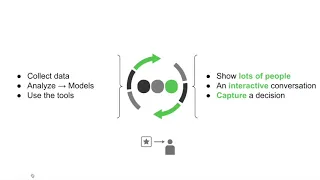
So
this
this
is
yeah
just
just
going
back
to
that
bimodal
distribution
of
sort
of
the
root
of
my
frustrations
is
like
a
lot
of
times.
This
is
because
people
don't
have
the
right
tools
to
use
and
the
concepts
therefore
aren't
approachable,
accessible
or
extensible
for
them,
and
so
what
I
have
tried
to
you
over
that
over
the
past
few
years
is
to
actually
provide
those
tools
to
actually
raise
people's
game.
So
people
saying
that
it's
the
greatest
tool
they've
ever
seen
and
I
like
putting
my
foot
up
on
the
space
and.