►
From YouTube: Full Building and Massing Presentation August 5, 2022
Description
Full Building and Massing Presentation August 5, 2022
A
A
A
So
without
further
ado,
I'd
like
to
present
to
you
some
material
that
we've
been
working
on
to
help
explain
how
the
zoning
work
that
we're
doing
the
high-level
policy
work
that
we're
doing
and
the
form-based
code
can
all
be
used
to
create
an
environment
in
the
city
of
arcata.
That
both
addresses
our
future
development
and
growth
needs,
as
well
as
respecting
the
values
and
aesthetics
that
we
all
have
for
the
city
of
arcata.
A
A
They
run
out
catch
some
of
the
commercial
properties
and
residential
properties
between
the
street
and
samoa,
and
then
the
boundary
zigzags
a
little
bit
to
get
over
to
k.
Street
up
alliance
comes
back
out
o
street
and
then
out
q
street.
It's
about
138
acres
of
land.
That
includes
a
variety
of
different
uses.
Currently,
that
we'll
talk
about
and
what
we're
really
going
to
be
focusing
in
on
this
particular
program
is
how
future
development
can
fit
within
the
existing
bounds
of
current
development
and
how
it
could
be
limited.
A
We
have
some
residential
high
density
properties,
some
residential
medium
density
properties,
as
well
as
some
commercial
and
finally,
some
residential
low.
So
it's
a
real
mix
of
different
zoning
districts
currently
in
this
this
area,
but
the
one
thing
that
all
of
this
area
has
in
common
is
there's
a
lot
of
redevelopment
potential,
but
then
many
of
the
parcels
are
included
in
this
area.
A
A
A
On
the
industrial
limited
you
can
go
up
to
45,
feet,
45
feet
and
the
residential
high
density
district
and
in
the
industrial
general
it
says
minimum
of
45,
but
it's
up
to
the
decision
maker,
so
it
could
be
greater
than
45
feet
commercial
districts.
You
can
go
35
and
38
feet
with
a
density,
bonus
and
residential,
low
density
or
38
feet
in
the
residential,
medium
density.
A
So
right
now
you
can
see
there's
a
range
of
different
building
heights
that
are
allowed
for
in
these
districts,
but
despite
those
upper
limits,
very
few
projects
have
really
maxed
out
these
building
envelopes
and
again
in
part,
that's
related
to
market
conditions,
but
in
part
it's
related
to
the
other
standards
that
we
have
in
our
zoning
codes.
So
I
want
to
keep
this
in
mind
that
the
zoning
code
is
built
based
on
both
these
maximum
building
heights,
as
well
as
these
other
standards
and
we'll
come
back
to
that
theme.
A
Many
times
throughout
this
presentation
right
here,
I'm
showing
you
the
arcata
gateway
area,
these
glass
boxes,
if
you
will,
as
they
are
currently
proposed
now
recall,
the
gateway
area
plan
is
in
draft
form
right
now,
and
so
this
is
all
subject
to
the
discretion
of
the
decision
makers
and
input
from
you.
So
I
want
you
to
continue
to
participate,
provide
us
feedback
on
these.
A
So,
what's
currently
proposed
well
in
the
barrel
district,
eight
stories
maximum
with
a
maximum
90
feet
in
the
hub.
You
have
80
feet
maximum
that
would
accommodate
seven
story:
buildings
corridor.
You
can
build
up
to
six
stories
with
a
70
foot
maximum
and
the
transition
60
feet
with
five
story
max
on
these
neighborhood
gateway
neighborhood.
A
A
Looking
like
this
glass
box
vision
here,
every
property
built
out
to
a
maximum
build
out
that
really
maximizes
the
bulk
and
mass.
That's
not
a
realistic
expectation
for
development
within
this
area,
and
it's
not
a
realistic
expectation
of
how
the
codes
that
would
be
implemented
to
further
regulate
development
beyond
just
setback
and
maximum
building
height.
A
A
All
of
these
white
buildings
are
three-dimensional
representations
of
actual
buildings
within
this
plant
area,
and
so
you
might
see
some
buildings
that
you're
familiar
with.
Maybe
you
see
the
building
that
you
live
in
or
work
in
then
you'll
see
these
other
buildings
that
that
are
not
in
the
plan
area.
Right
now.
This
is
bud's
mini
storage
right
here
we've
got
a
rough
model
built
for
butts,
mini
storage,
showing
some
features
there.
A
There's
the
amerigas
parcel
car
wash
parcel,
and
so
we're
going
to
use
these
to
visualize
how
the
form
base
code
can
further
refine
what
the
development
potential
is
on
these
sites.
That
goes
to
limit
these
to
more
than
just
these
glass
boxes,
so
just
summarizing
real
quick.
You
know
current
zoning
that
we
have
in
place
right
now
allows
for
45
foot
tall
buildings
in
general.
You
can
build
a
four-story
building
in
most
of
the
plant
area.
A
A
We
also
went
beyond
that
with
some
of
these
parcels
and
added
a
more
refined
model.
This
more
refined
model
takes
a
look
at
how
building
setbacks
the
ground
floor
on
upper
floors
and
how
articulation
of
the
buildings
could
further
enhance
both
the
the
aesthetics
of
them
and
also
reduce
the
impacts
of
these.
These
new
proposed
buildings-
and
I
want
to
be
real
clear
at
this
point-
that
none
of
these
models-
none
of
the
glass
boxes,
are
fixed.
These
are
just
representational
so
that
we
can
start
to
understand
how
the
code
would
interact.
A
None
of
these
are
proposed
actual
buildings,
and
so
I
don't
want
anybody
to
look
at
this
and
think
that
we've
got
a
vision,
for
you
know
what
buildings
might
actually
be
built
out
right
now.
These
are
simply
models
to
help
us
understand
how
these
building
forms
would
impact
on-site
and
off-site
existing
and
future
builds.
A
A
A
Under
current
zoning
there's
a
total
glass
box
volume
that
is
much
much
larger
than
the
actual
build
out
volume.
Again.
Here's
the
car
wash
on
the
right
of
the
screen
and
the
mini
storages
on
to
the
left
of
the
screen,
and
in
fact
you
can
look
throughout
the
zoomed
in
portion
of
this
district
and
see
that
none
of
the
existing
buildings
are
built
out
to
that
full
potential.
A
A
total
elevation
of
45
feet
that
could
be
built
out
to
and
looking
into
the
future
with
the
proposal
and
this
rough
model
that
would
bring
us
up
to
a
total
of
70
feet,
build
out
potential.
This
rough
model
encompasses
a
portion
of
the
property
you
can
see.
The
creek
is
still
the
daylighted
portion
of
the
creek
is
still
there
represented
by
this
green
area
here
and
in
this
particular
build.
There
are
five
stories
with
that
upper
floor.
A
A
A
You
can
see
upper
floor
setbacks,
as
we've
discussed
about
three
stories,
as
well
as
lower
floor
setbacks.
Some
of
these
can
be
attributed
or
used
for
public
purposes
can
see
some
attempt
to
show
how
articulation
of
the
building
form
could
affect
the
massing
and
reduce
the
the
sense
of
the
building.
In
addition,
we
have
some
site-specific
standards
that
might
be
applied
on
particular
sites.
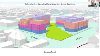
This
car
wash
site,
for
example,
has
real
potential
to
allow
for
daylighting
of
a
creek,
and
so
we've
shown
that
here
so
there's
no
development
on
that.
A
So
what
are
the
elements
of
the
form
based
code
that
we've
just
looked
at
here
for
one
there's
placement
on
the
street?
There's
the
building
form
the
bulk
and
massing
of
it
where
it
sits
on
the
lot.
What
are
the
setbacks
we
can
affect
all
of
those
with
this
form
based
code
approach,
there's
also
the
building
standards.
What
do
we
want
the
buildings
to
look
like
what
types
of
architectural
features,
how
much
window
opening
how
much
glazing
where
we
want
the
doors?
A
How
do
we
want
placement
of
you
know
those
those
public
intersections
between
the
private
and
the
public
space,
how
much
landscaping
and
so
on
and
so
forth,
and
then
we
can
also
address
site
design
standards,
including
landscaping.
You
know
these
publicly
accessible
private,
open
spaces
that
would
be
secured
through
easements
and
other
features
of
the
development
that
really
reflect
on
to
the
public
right-of-way.
A
A
A
This
very
nice
aesthetically
pleasing
design
could
be
incorporated
onto
the
site
within
that
framework
and
it's
a
way
of
understanding
how
that
framework
can
then
lend
to
development
of
projects
that
really
enhance
the
area.
The
form-based
code
could
even
go
as
far
as
defining
some
of
these
features,
maybe
where
the
balconies
land,
where
the
openings,
how
how
frequent
the
opening
should
be
for
you
know,
for
public
spaces.
A
This
particular
site
is,
is,
you
know,
filled
up
with
basically
five-story
buildings
and
four-story
buildings,
and
we
can
define
all
of
that.
Obviously,
the
more
definition
we
give
to
the
code,
the
more
detail.
There
is
the
more
time
and
energy
and
money
we'll
have
to
put
into
that
code.
But
if
that's
the
direction,
this
community
wants
to
go
to
ensure
that
it
knows
what
development
is
going
to
come
out
of
this.
A
That
is
an
option,
leaving
the
framework
a
little
bit
more
vague,
maybe
a
little
bit
more
detailed
than
this,
but
a
little
bit
more
vague
will
get
us
to
a
code
more
quickly
and
it
will
allow
for
more
flexibility
and
design,
leave
the
architects
to
do
their
work
and
create
these.
These
really
nuanced
spaces.
A
So
again,
just
recapping
maximum
height
and
building
setbacks
are
sort
of
the
first
layer
design.
There
are
several
more
that
can
be
implemented.
The
form
based
code
would
further
refine
setting
boundaries
on
development,
including
not
only
the
upper
four
setbacks,
but
up
to
and
including
how
much
glazing
is
on
the
frontage.
You
know
what
those
street
amenities
would
be
where
the
public,
accessible,
private,
open
space
would
be,
and
the
forum
based
code
provides
standards
on
a
range
of
facets
for
development
that
go
beyond
that,
including
potentially
street
trees
and
etc.
A
A
We're
going
to
go
back
and
take
a
look
at
the
car
wash
now
looking
at
it
from
the
aerial
image
looking
west
southwest,
and
you
can
see
10th
street
there
in
the
foreground
running
out
to
the
bottoms
and
what
we're
going
to
evaluate
here
is
impacts
on
shading,
so
here's
our
model
we're
going
to
zoom
in
a
little
bit.
This
is
again
our
rough
model.
You
can
see
the
glass
boxes
and
the
rough
model
inside
the
car
wash
parcel
there.
A
A
A
A
The
two-hour
shadow
cast
is
to
about
10
feet
within
the
prop
front
property
lines,
the
southern
property
lines
of
those
properties
we
looked
at
before,
and
so
recognizing
that
the
as
we
get
closer
to
the
summer
and
the
sun
gets
higher
in
the
sky,
you're
going
to
have
fewer
and
fewer
impacts.
So
december,
20
is
kind
of,
like
worst
case
scenario,
we're
starting
to
see
those
resolved
by
february
in
this
real
rough
model
that
we've
got
well.
A
Now
it
does
cast
on
to
the
buildings,
but
not
all
the
way
up
to
the
rooftops
again.
This
is
two
hours
of
shading
on
december
20th
by
february.
Two
hours
of
shading
is
all
the
way
out
to
the
street
and
there's
no
impact
on
the
rooftops,
and
so
the
vast
majority
of
the
year
there's
no
shading
across
the
street
to
the
other
existing
development
or
even
proposed
development
on
the
german
motors
back
parking
lot,
if
that's
to
develop
in
the
future.
A
Gis
model
can
also
show
us
what
hourly
shading
looks
like,
and
so
here,
you're
looking
at,
that
same
refined
model
that
we're
working
with
that
could
be
the
result
of
a
form
base
code,
and
you
see
these
pools
of
shadows
getting
progressively
lighter,
representing
fewer
and
fewer
hours
of
shading
extending
outward
from
the
the
building,
and
this
is
in
february,
so
we're
looking
at
the
area
where,
by
february
this
building
had
no
impact
on
the
two-hour
model.
You
can
see
that
it
does
shade
the
exit,
the
adjacent
parcels
to
some
extent.
A
So
how
much
we
don't
know
how
much?
To
that
extent,
this
area
right
here
is
45
minutes
there
you're
up
to
60
minutes,
so
you're,
almost
off
the
property
before
you
get
to
an
hour
and
it's
five
hours
in
the
middle
of
the
street.
There
are
many
places
within
the
city
of
arcade.
I
think
you'll
find
that
you
get
five
hours
of
shading
in
the
middle
of
the
street
with
any
sized
building,
but
this
shows
how
you
can
ameliorate
the
impacts
to
other
property
owners,
if
not
to
the
street.
A
So
again,
just
recapping
the
form-based
code
can
refine
what
you're
seeing
in
the
jewel
box.
It
can
further
refine
what
you're,
seeing
in
the
rough
model
and
the
foreign
base
code
can
really
address.
You
know
a
lot
of
these
impacts
that
we're
all
concerned
about
those
decisions
will
be
adopted
by
the
council
and
so
to
the
concerns
that
we're
gonna
adopt
some
kind
of
code
that
would
have
undue
impacts
on
the
adjacent
neighbors.
A
I
just
wanna
remind
us
all
that
the
council
is
in
charge
of
that
process
and
is
very
interested
in
hearing
from
you,
and
so,
if
you
have
particular
ideas,
they
want
to
hear
about
them.
The
planning
commission
also,
likewise,
is
an
important
recommending
body
to
the
council
on
this,
and
they
want
to
hear
your
thoughts
too.
A
Okay,
in
light
of
the
design
standards,
how
many
properties
are
likely
to
build
out
taller
than
five
stories?
I've
seen
some
commentary
in
the
public
forum
that
you
know
we're.
Gonna
have
five
six
seven,
eight
story,
buildings
all
throughout
the
the
entire
gateway
area.
That's
just
unrealistic
for
a
couple
of
reasons.
A
Okay,
so
in
terms
of
the
market
forces,
I
want
to
reflect
back
on.
A
couple
of
maps
are
in
the
draft
plan.
Right
now
to
the
right.
You
see
the
districts
there's
the
barrel
district
in
yellow
the
gateway
hub
and
blue
corridor
and
orange,
and
the
neighborhood
in
brown,
showing
you
both
maximum
stories
and
the
maximum
height
that
developments
can
build
out
to
currently.
Based
on
the
draft
plan
on
the
left,
you
have
the
sites
that
are
identified
as
opportunity
sites
within
the
gateway
area
plan.
A
These
are
sites
that
have
a
lot
of
potential
for
future
development
and
are
largely
viewed
as
the
areas
that
are
going
to
provide
them
the
majority
of
future
development
over
the
next
20
to
50
years.
In
this
plan,
I
looked
at
these
opportunity
sites
and
broke
them
into
sites
that
are
vacant
and
ready
to
develop.
As
soon
as
this
plan
is
adopted,
these
three
sites
could
probably
develop.
You
know
immediately.
A
So
from
a
market
standpoint.
These
sites
are
the
ones
that
are
the
most
ready
to
go.
There
are
economic
factors
that
inhibit
someone
making
the
decision
for
tearing
down
an
existing
building
and
building
a
new
one,
even
if
that
new
one
could
produce
marginally
higher
rates
of
return
within
those
sites,
we
have
36
acres
so
of
the
183
acres
or
so
there's
36
acres
that
run
between
1400
and
1800
units
with
with
that
amount
of
development
potential.
A
So
the
the
proposition
I'm
making
here
is
that
most
of
the
sites,
if
you
wanted
to
know
how
many
sites
are
going
to
develop
out
with
those
taller
stature
buildings,
most
of
the
sites
are
going
to
be
late
to
market.
If
you
have
a
site,
that's
already
got
development
on
it,
they're
not
likely
to
redevelop
as
quickly
as
these
sites
are.
There
are
only
so
much
units
that
are
going
to
be
absorbed
in
any
given
year
and
once
those
units
are
on
the
market,
there's
a
disincentive
for
others
to
to
develop
their
site.
A
A
Let's
switch
gears
a
little
bit
and
look
at
how
the
form-based
code
can
be
used
to
address
this
question,
we're
looking
again
at
the
samoa
and
k
street
corridor.
So
this
is
this
greenish
color
is
in
the
corridor
district,
and
this
pinkish
color
is
in
the
gateway
neighborhood
we're
looking
at
some
models
that
were
developed
for
the
amerigas
site,
the
buds
mini
storage
and
the
former
saint
benny's
here,
and
then
you
can
see
again
in
white
the
existing
buildings
in
this
area,
along
with
the
parcel
lines
around
those
properties.
A
So
before
we
answer
the
question,
how
many
of
these
properties
are
likely
to
develop
out
at
five
stories
or
grade
group?
I
want
to
look
at
some
of
the
principles
that
we
talked
about
form-based
code
for
shading,
because
we
would
apply
those
in
these
areas
to
ensure
that
adjacent
neighbors
don't
get
unduly
shaded
by
this
new
development.
A
So
taking
a
look
at
that,
if
you
imagine
that
this
outer
box
is
the
parcel
boundaries,
this
blue
box
here
with
parcel
boundaries
before
you
start
a
development,
that's
going
to
be
five
stories
tall
you're
going
to
want
some
pretty
significant
setbacks.
So,
let's
put
a
20-foot
setback
on
the
ground
level.
Before
you
start
building,
you
have
to
have
at
least
20
feet
set
back.
A
We've
talked
about
upper
floor
setbacks.
I
think
it's
appropriate
to
evaluate
20
feet
as
an
upper
floor
setback,
so
you
might
be
able
to
build
three
floors.
This
blue
box
here,
that's
inside
the
lighter
blue
box,
might
be
able
to
build
three
floors
with
the
20-foot
setback
and
then
to
build
to
the
fourth
and
fifth
floor.
You'd
have
to
have
another
20-foot
setback,
so
greater
than
three
floors.
20
and
20
or
40
feet
back
the
minimum
building
distance
is
30
feet.
We're
using
here.
A
So
using
that
to
evaluate
the
parcels
that
were
in
that
image
that
I
showed
you
previously,
we
can
tell
which
of
these
parcels
meet
that
90-foot
setback
or
that
that
90-foot
axis
requirement.
Excuse
me
evaluating
those
these
parcels
here.
They
don't
have
90
feet
minimum.
So
they
can't
be
developed
with
five-story
buildings
under
this
scenario,
just
not
going
to
happen
with
that
that
standard
set
these
sites.
Here,
it's
an
open
question.
It
depends
on
what
we
do
with
the
east-west
access
setbacks.
A
So
let's
come
back
to
these
questionable
properties.
We
want
to
know
what
are
these
going
to
get
developed
or
not,
and
the
answer
is:
it
depends
on
how
aggressive
the
decisions
are
made
about
how
much
development
development
we
want
in
these
given
areas,
and
we
can
tune
this
in
for
certain
areas.
If
we
want
to
have
more
development
and
certain
areas
we
want
to
have
less
development,
we
can
fine-tune
those
with
that
form
based
code.
Let
me
explain
what
I
mean
here.
A
If
we
have
building
setbacks
like
we
have
in
the
downtown,
with
zero
lot
line
setbacks
between
adjacent
buildings
between
adjacent
properties,
as
you
see
here,
with
no
separation
between
buildings,
the
property
line
goes
right
between
buildings
that
are
smashed
right
up
against
one
another.
In
that
kind
of
scenario,
then
yeah
these
sites
would
be
completely
developable.
A
You
could
have
north-south
access
setbacks
that
ameliorate
impacts
to
the
neighbors
to
the
north,
and
you
could
have
wall-to-wall
adjacent
developments
on
the
east-west
axis
and
you'd
be
able
to
develop
all
of
those
properties.
So
that's
a
choice.
Zero
lot
line
setback
is
a
choice
which
would
increase
the
development
potential
and
allow
for
larger
stature
buildings
on
these
sites.
A
What
if
we
wanted
to
have
some
separation
we're
going
to
allow
for
zero
lot
line,
set
back
on
one
side?
So
in
this
diagram
on
the
low
end,
you
have
zero
lot
line,
but
we
want
to
ensure
that
there's
some
clear
space,
some
some
breathing
room
between
buildings
on
the
other
side,
so
each
building
is
allowed
to
be
offset
with
a
zero
lot
line,
set
back
on
one
side
and
a
slightly
larger
setback
on
the
other.
A
What
would
happen
to
these
properties
then?
Well,
the
answer
is:
maybe
it
depends
on
how
wide
you
want
that
separation
distance
and
how
wide
these
parcels
are,
so
some
of
them
might
be
able
to
be
developed,
and
some
of
them,
probably
wouldn't
under
this
scenario
and
then
sort
of
the
third
option-
would
be
to
have
a
greater
setback.
So
in
this
situation
you
have
setbacks
from
each
building
type
on
both
sides
of
the
property,
and
maybe
you
want
to
have
large
setbacks
and
ensure
that
those
large
setbacks
are
used
for
other
purposes.
A
A
So
what
do
we
need
to
balance
when
we're
considering
building
height
the
you
know,
relationship
between
building
height
and
public
amenities,
the
number
of
parking
spaces
that
we
have
the
amount
of
area
we
can
dedicate
to
alternative
transportation.
All
of
these
things
are
based
on
how
much
land
we
dedicate
to
which
purpose,
and
so
I
want
to
explore
the
relationship
between
building
height
and
unit
count
and
look
at
how
that
affects
the
open
space
available
on
properties.
Just
take
one
view,
a
couple
of
parameters
and
look
at
how
they
interact.
A
A
A
This
is
just
a
model
to
help
us
understand
how
building
elevation
and
proportion
of
mix
of
building
elevations
affects
unit
count.
No
one
is
proposing
that
there
be
eight
story:
buildings
throughout
the
district,
certainly
not
throughout
the
entire
gateway
area,
and
so
this
is
for
modeling
purposes
only.
A
We
also
wanted
to
look
at
what
happens
if
you
limit
it
to
six
stories
so,
instead
of
allowing
for
eight
stories
in
the
barrel
district
that
is
currently
allowed.
What?
If
we
said,
six
stories
was
the
max
in
the
barrel
district
100
percent,
four
stories
100
six
stories,
so
the
proportions
changing,
and
so
these
proportions
are
the
same
with
four
and
four
six
and
eight
as
they
are
with
four
five
and
six,
and
so
we
can
compare
the
totals.
A
A
Now.
The
first
thing
you
may
be
thinking
to
yourself
was:
that's
not
a
very
big
difference,
so
why
all
the
consternation
over
eight
stories
versus
some
lower
number?
I
think
that's
a
really
good
question
that
we
need
to
explore
and
that's
part
of
the
reason
why
we're
looking
at
this,
you
might
also
be
looking
at
the
four
story.
Unit
count.
A
A
A
Open
space
is
going
to
be
green
right
now
you
see
the
parcel
that
we're
going
to
be
playing
with
here
in
green
and
black
gives
you
a
reference
for
the
sidewalk
and
we're
going
to
be
looking
at
site
plan
view
and
build
an
elevation.
So
there's
going
to
be
the
side
view
and
there's
going
to
be
the
top
view
of
these
buildings
in
these
different
scenarios.
A
So
looking
at
a
three-story
building
three-story
building
in
order
to
hit
44
units
on
a
30,
000
square
foot
lot
with
the
parameters
that
we
used
takes
up.
100
of
the
lot
coverage
there's
almost
zero
open
space
in
this
model,
and
so
you
can
get
that
44
units
on
a
30,
000
square
foot
site
by
covering
the
entire
thing.
A
A
A
So
when
I
go
back
to
the
example
of
the
the
model
where
it
showed
that
you
can
get
just
about
the
same
number
of
units,
all
of
the
things
being
equal
out
of
100
four
stories
versus
a
mix
of
four
six
and
eight
or
a
mix
of
four
five
and
six,
that
is
true,
you
can
get
about
the
same
number
of
housing
units.
The
question
that
you
have
to
ask
then
next
is
how
much
of
that
space
in
this
area.
Do
I
want
to
dedicate
to
getting
those
housing
units?
A
So
here's
where
we
need
to
weigh
the
policy
decisions
against
providing
more
housing,
finding
more
open
space
or
providing
other
amenities
within
the
community,
now
reflect
this
green
space.
Here,
that's
on
this
five-story
building.
Some
of
that
could
be
dedicated
to
the
uses
on
that
site,
so
you
might
have
some
private
recreation
space
for
the
users
of
that
site.
A
But
one
of
the
core
features
of
this
program
is
that
these
these
new
developments
will
also
contribute
to
the
public
realm
and
so
we'd
be
able
to
get
a
tot
lot
or
maybe
a
nice.
You
know
corner
parklet
or
a
seating
area
or
you
know
expanded
sidewalks.
So
these
kinds
of
public
amenities
can
come
out
of
allowing
for
taller
buildings
that
free
up
more
of
the
site
for
other
uses.
A
I
want
to
transition
into
a
little
bit
more
of
a
nuanced
and
and
higher
level
conceptual
financial
model
that
looks
at
the
relationship
between
unit
density
and
the
feasibility
of
building
these
projects
to
begin
with,
because
those
two
things
are
related
as
well.
If
we
said
well,
we
want
to
go
with
four-story
buildings.
We
want
to
go
with
larger
site
plans,
larger
sites
that
are
dedicated
to
the
area.
A
That's
going
to
inhibit
the
ability
for
developers
to
build
units
and
the
units
is
what
make
these
projects
pencil
so
before
we,
you
know,
go
off
on
the
idea
of
saying:
well,
let's,
let's
just
have
a
smaller
building
footprint
and
lower
unit
count
and
we'd
be
happy
with
that.
You
have
to
ask
the
question:
is
it
financially
feasible?
A
A
All
of
those
run
on
the
same
conceptual
principles
that
I'm
gonna
explain
to
you
using
this.
This
graphic
on
this
axis
we're
looking
at
the
cost
per
dwelling.
So
this
is
how
much
it
costs
to
produce
each
dwelling
unit
in
any
of
those
different
kinds
of
scenarios
on
the
bottom.
Here
you
have
density,
it's
the
number
of
units
that
are
allowed
in
the
code
per
you
know,
per
area
of
land.
You
typically
use
acres
in
our
codes.
A
A
This
orange
line
is
always
going
to
be
higher
than
the
average
cost
per
unit,
because
it's
basically
taking
the
incremental
cost
of
adding
new
units
called
the
marginal
cost.
So
every
time
you
add
a
new
unit,
you're,
adding
new
margin
to
the
cost
of
the
development,
and
this
dashed
line
is
the
market
price.
This
is
the
price
that
you
would
get
either
for
rent
or
for
sale
of
the
unit.
A
It
will
at
some
point,
hit
what
is
considered
the
market
price
that
market
price
across
where
the
marginal
cost
crosses
the
market
price
is
referred
to
as
the
optimal
density.
This
is
the
density
at
which
the
project
is
penciling
best.
It's
making
the
most
return
on
the
investment.
It
makes
the
most
sense
for
the
developer
to
do
it.
A
A
Then
the
project
is
just
not
going
to
pencil
at
all.
It's
just
you're
never
going
to
pencil
it.
So
that
means
that
the
the
development
won't
be
built,
and
so
the
way
to
look
at
this
is
that
the
developer
is
always
going
to
want
to
hit
this
optimal
density
point,
but
we'll
accept
being
within
this
range.
A
These
two
areas
are
infeasible
so
from
a
financial
feasibility
point
you
get
above
the
market
price
or
you
get
below
the
area
of
the
land
value
and
the
project
isn't
pencilling
either
because
you're
getting
diminishing
returns
on
the
investment.
So
there's
no
point
in
investing
more
or
because
the
marginal
cost
doesn't
maximize
the
return
on
the
investment
to
the
point
or
even
meet
the
threshold
criteria
for
getting
a
return
on
the
investment.
A
So
this
is
going
to
vary
by
by
you
know,
area
it's
going
to
vary
by
market.
It's
going
to
vary
by
by
development
type.
There's
lots
of
detail
to
this,
but
I
want
us
to
understand
this
concept
that
there's
a
goldilocks
range
in
density,
where,
if
we
don't
set
the
density
high
enough
you're
going
to
be
in
this
region
and
the
projects
are
going
to
be
infeasible.
A
If
you
set
the
density
too
high,
let's
say
eight
story:
buildings
are
in
this
range,
where
the
marginal
cost
is
never
going
to
pencil
to
make
that
return
on
the
investment
you're,
never
going
to
see
an
eight-story
building
built,
but
what
you
will
see
built
is
what
the
market
can
bear,
and
so
this
might
be
four.
This
might
be
five.
A
A
There's
that
I'd
like
to
talk
to
you
about,
but
I
wanted
to
make
sure
that
we
got
through
some
of
the
features
on
how
form-based
code
can
further
ameliorate
some
of
the
impacts,
some
of
our
biggest
fears
about
what
arcade
might
look
like
in
the
future.
If
we
allowed
every
site
to
develop
out
like
these
glass
boxes,
that
is
not
the
proposal.
A
No
one
has
suggested
that,
and
I
understand
it's
been
a
little
vague
in
some
some
ways,
but
the
next
steps,
as
we
move
through
this
form
gate
base
code
process,
will
further
refine
these
glass
boxes
to
give
us
a
better
understanding
around
how
we
want
to
grow
as
a
community
and
we're
doing
that
work
together.
So
again,
my
name
is
david
loya,
I'm
the
director
of
community
development.
I'd
like
to
hear
from
you.
I
know
the
council
would
love
to
hear
from
you.