►
From YouTube: Transportation Commission Meeting | June 29, 2023
Description
No description was provided for this meeting.
If this is YOUR meeting, an easy way to fix this is to add a description to your video, wherever mtngs.io found it (probably YouTube).
A
Foreign
good
evening,
everyone
today
is
Thursday,
June,
29,
2023
and
we're
here
at
the
Transportation
Commission
meeting.
This
is
a
hybrid
meeting,
which
means
we
are
joined
in
person
and
virtually
my
name
is
Bridget
obicoya
and
I
am
the
Transportation
Commission
liaison,
and
this
meeting
is
being
recorded.
So
if
you
are
joined
virtually
please
turn
off
your
mics
and
teens.
B
A
C
C
C
C
The
third
part
is
Project
selection,
scoping
and
concept
development.
The
staff
work
on
this
and
then
move
into
public
engagement
to
share
with
folks.
You
know
locally
in
the
neighborhood
about
the
project
and
get
their
thoughts
and
feedback
on
what
to
do
in
terms
of
how
to
make
the
street
safer
and
more
complete
and
then
once
that
public
engagement-
and
you
know,
project
scoping
process
is
at
about
I
think
what
are
we
ten
percent
Michelle
or
30
somewhere
sort
of
relatively
early
in
the
design
process?
C
It
then
comes
back
to
the
complete
streets.
Commission,
neighborhood,
complete
streets
commission
for
a
funding
hearing,
and
so
when
we
do
the
funding
hearing
the
staff
bring
us.
You
know
the
details
of
some
of
the
details
of
the
project.
What
the
design
the
sort
of
early
design
looks
like
and
what
the
estimated
costs
will
be,
and
then
the
complete
streets,
commission
votes
and
on
Monday.
We
voted
to
recommend
three
projects
for
approval
and
now,
like
I,
said
we're
between
space,
five
and
Space.
C
C
So
I'm
going
to
give
you
sort
of
like
a
quick
overview
of
each
project
and
why
you
know
we
chose
it
and
why
it's
on
the
list
and
then
Michelle
can
walk
you
through
a
bit
of
the
proposed
design
for
each
so.
The
first
project
we're
looking
at
is
14th
Street
North
between
North
Ohio
street
and
North
McKinley
Road
in
the
Highland
Park,
overly
Knolls
neighborhood,
and
you
can
see
there's
a
little
map
here.
That
shows
you
where
this
project
is
so
the
scope
of
the
project.
C
The
kind
of
improvements
that
the
program
is
looking
to
make
is
to
install
continuous
sidewalk,
upgrade
the
Ada
curb
ramps
and
create
some
high
visibility,
marked
Crossings.
So
we've
done
some,
the
you
know.
Staff
especially
has
led
a
lot
of
public
engagement
as
they
always
do,
and
very
sort
of
targeted
public
engagement
for
each
project,
which
included
a
web
page
online
feedback
form
Flyers
meeting
on
site
lots
of
different
stuff.
C
So
the
reason
that
this
project,
one
of
the
reasons
why
this
project
is
here,
is
because
it
is
a
fourth
on
the
list
of
the
more
than
100
100
projects
that
we
have
due
to
a
lot
of
different
issues
there.
So
the
proposed
scope
for
where
we
are
right
now
would
put
this
project
at
around
587
thousand
dollars.
D
D
There
is
some
sidewalk
we're
going
to
pick
up
from
this
section
of
sidewalk
and
build
on
the
north
side
of
the
street,
which
is
the
left
side
of
the
left
picture,
and
this
picture
on
the
right
is
the
other,
the
other
end
of
the
project
area,
where
the
sidewalk
will
be
on
the
right
side,
so
building
on
the
north
side
of
the
street
intentionally.
So
there
are
utility
pools
and
street
lights.
D
The
utility
poles
are
actually
on
both
sides
of
the
street,
so
these
are
some
of
the
existing
constraints,
but
also
trying
to
work
around
a
stand
of
mature
trees
that
are,
we
will
would
like.
We
chose
the
north
side
to
avoid
them
in
order
to
get
the
street
with
that.
We
need
and
minimize
impacts
to
both
the
constraints
of
the
utility,
poles,
the
street
lights,
the
mature
trees
and
people's
Frontage.
We
are
looking
to
remove
some
amount
of
parking
on
the
street.
D
Additionally,
there
are
some
properties
on
the
south
side
of
the
street
that
have
no
off
street
parking,
so
we
ensured
that
the
parking
wasn't
being
removed
in
front
of
those
properties.
Additionally,
to
highlight
that
we're
looking
to
build
out
two
new
curb
extensions
at
McKinley
Road
to
try
and
slow
the
Turning
movements
both
on
to
this
block
of
street,
but
also
going
from
the
street
onto
Northbound
on
McKinley
and
then
again,
picking
up
with
a
recent
project
on
Ohio
Street
think
that's
all
I
have
for
right.
Now
that
missed
anything
Elisa.
C
D
C
C
So
this
project
is
on
our
list
tied
four
sixth
with
46
points,
largely
because
of
crashes
and
crashes
with
injuries
and
then
high
traffic
volumes,
and
so
we're
looking
at
here,
installing
new,
curb
extensions
and
accessible,
curb
ramps,
making
some
Market
Crossings
and
improving
the
signage.
Overall
again,
you
know
a
lot
of
public
engagement
website
online
feedback
form
Flyers.
C
D
Never
get
old,
forgetting
to
turn
your
mic
back
on,
in
this
case,
we're
looking
at
two
intersections
we're
focusing
our
efforts
on
they
in
the
case
of
Dickerson.
It's
just
a
very
large
intersection
with
excessive
Crossing
distances
than
a
fairly
relatively
high
volume,
neighborhood
street,
so
we'll
be
looking
to
shorten
that
Crossing
distance
in
both
directions
at
8th
and
Dickerson,
with
upgraded,
accessible,
curb
ramps.
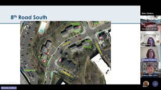
The
picture
on
the
right
is
the
intersection
of
Emerson
and
eighth
Road.
D
You
cannot
see
it,
but
there
are
actually
two
curb
ramps
on
the
right
side
of
the
picture,
but
they're
blocked
by
parked
cars.
Those
two
curb
ramps
do
not
have
a
typical
geometry
between
the
receiving
curb
ramps
and
the
other
side
of
the
street.
So
excuse
me,
this
design
is
looking
to
replace
those
two
curb
ramps
and
put
them
improve
the
geometry
with
a
single
curb
ramp,
that's
in
a
more
visible
location,
which
I
can
show
you
in
the
next
slide.
D
So
again,
this
is
the
intersection
with
Dickerson,
where
there'll
be
curb
extensions
into
eighth
road
to
neck
down
the
road
through
the
intersection.
The
amount
of
reduction
in
the
Crossing
on
Dickerson
is
less
because
it's
a
narrower
Street.
There
are
eight
curb
ramps
with
detectable
warning
strips
all
the
usual
good
stuff,
the
Emerson
intersection
to
the
South.
D
You
can
see
where
we're
removing
two
curb
ramps
that
are
in
inopportune
locations,
I,
think
they
were
added
sort
of
as
part
of
Street
repaving
and
probably
best
available
option
at
the
time.
Without
a
capital
project,
we
will
be
straightening
the
crossing
and
locating
it
just
one
in
the
most
visible
location
and
there
may
be
opportunities
to
I
know
we
got
some
feedback
about
whether
or
not
that
we
can
put
in
a
curb
extension
on
both
sides.
C
All
right
and
then
the
last
project
for
tonight
is
South
Irving
Street.
So
this
is
an
entire
Corridor
of
projects
that
has
been
broken
into
three
different
segments,
and
so
these
three
different
segments
were
all
individually
nominated,
and
so
we
have
already
looked
at
segment
B
and
it
is
a
funded
Capital
project
that
you
all
I
believe
saw
during
our
last
funding
round
and
then
segment
c
is
kind
of
on
hold
for
now.
C
D
So
this
section
of
Irving,
the
utility
pools,
are
on
the
east
side
of
the
street,
and
the
street
lights
are
on
the
west
side
of
the
street.
We
have
elected
to
improve
the
sidewalk
on
the
west
side
of
the
street,
because
that
connects
to
the
sidewalk
project
that
we
will
be
constructing
for
the
block
to
the
South.
So
this
provides
a
an
additional,
fully
accessible
walk
group
connecting
the
two
Camp
school
campuses
in
the
Arlington
Heights
Community,
with
the
TJ
Fleet
campus
to
the
North
and
the
Montessori
career
center
campus
to
the
South.
D
This
will
provide
an
another,
a
fully
accessible
route,
at
least
on
the
west
side
of
the
street.
The
obstructions
in
the
sidewalk
are
comically
bad
with,
as
I
said,
street
lights,
utility
pools
and
we
do
not
have
I
included
the
picture
to
the
right
to
indicate
or
to
demonstrate
that
we
do
not
have
right-of-way
behind
the
sidewalk.
So
we
don't
have
the
option
of
relocating
the
street
lights
into
the
green
space.
D
On
the
other
side
of
the
sidewalk,
we
will
be
having
to
find
create
a
space
for
them,
so
this
design,
which
will
come
at
the
extent
of
only
six
on-street
parking
spaces
in
the
three
block
stretch,
we'll
relocate
the
Carlisle
Street
lights,
which
will
be
upgraded
with
modern
ones
or
latest
standard
into
these
curve
extensions.
So
the
curb
extensions
which
are
just
I
know
it's
a
different
designer,
a
little
bit
different
presentation
that
pink,
magenta
color
indicates
concrete,
so
you
can
see
where
the
curb
and
the
driveway
aprons
and
the
sidewalk
are
located.
D
D
I
want
to
also
highlight
that,
although
the
curb
extensions
that
we
will
be
building
would
be
building
to
facilitate
removing
the
obstructions
are
in
the
parking
Lane.
Therefore,
the
travel
way
does
not
change,
so
we
we
don't
have
any
conflict
over
Street
width
and
fire
code.
In
this
case,
however,
we
do
expect
and
Hope
that
there
will
be
some
traffic
calming
benefit
from
the
appearance
of
narrowing
of
the
road
in
those
locations.
D
Again,
the
curb
extensions
are
in
the
parking
Lane,
but
as
you
go
in
the
the
curb
line,
Meander's
thumb,
we
think
that
this
could
have
some
traffic
calming
benefit.
In
addition
to
the
fact
that
a
portion
of
this
project
area
is
in
a
new
school
slow
zone,
so
there
will
be
speed
monitoring
that
will
continue
through
both
efforts
in
tandem
in
the
future.
D
I
think
that
oh
and
I
did
I
forgot
about
my
funny
little
Graphics,
but
we
did
test
two
different
designs:
one
to
put
cobras
instead
on
the
existing
utility
poles
and
just
remove
the
Carlisle
Street
lights
entirely.
That
did
not.
That
was
not
popular
in
the
neighborhood,
so
we
are
100.
Listening
to
the
neighborhood
and
they're
very
high
priority
to
maintain
the
aesthetic
of
the
Carlisle
Street
lights,.
C
B
Great
thank
you
for
an
excellent
presentation.
Commissioners.
If
you
have
any
questions
or
comments,
please
go
ahead
and
raise
your
physical
hand
or
your
virtual
hand.
If
you're
on
teams
and
I
will
just
kick
things
off
with
a
couple
comments,
always
supportive
of
NC
NS,
neighborhood,
ncsc
projects,
great
I
love
this
program
great,
to
see
you
here
and
you
know
able
to
actually
fund
multiple
capital
projects.
It
was,
it's
always
been
a
fight
to
get
you
all
capital
money.
B
As
far
as
some
some
individual
details,
I'm
supportive
of
all
three
of
these
projects,
I
really
like
the
use
of
alternate
side
parking
to
create
chicanes
on
that
first
project
on
the
Irving
Street
project,
I'm
a
little
concerned
by
the
weirdness
of
how
the
sidewalk
ramps
are
shown
at
Third,
Street
and
5th
Street.
It
really
seems
like
a
tricky
thing
to
navigate,
maybe
for
a
child
on
a
bike
which
I
know.
B
There
are
certainly
plenty
of
kids
biking
to
school,
who
are
only
feeling
comfortable
on
the
sidewalks,
not
in
the
street.
So
we'd
really
like
to
see
that
smoothed
out
and
some
more
attention
paid
there
to
The
Pedestrian
experience
getting
down
that
that
greatly
improved
otherwise
sidewalk
that
will
no
longer
have
stuff
in
the
middle
of
it.
B
I
think
my
daughter
will
be
jazzed.
She
often
walks
down
Irving
coming
home
from
Fleet,
so
that
will
be
a
quality
of
life
Improvement
for
her
and
then
on.
Eighth
Road,
I
I
want
to
join
I,
think
the
chorus
of
other
people.
You
have
heard
about
the
need
for
the
those
curb
extensions
to
go
further.
I
really
think
Emerson
Road
needs
curb
extensions,
not
just
eighth
Road.
In
my
opinion,
there's
no
reason
for
the
crossing
distance
on
any
of
these
tiny
neighborhood
streets
to
be
more
than
about
20
or
22
feet.
B
You
know.
If
a
car
could
be
taking
up
seven
feet,
then
a
curb
extension
should
come
out.
You
know
at
least
seven
feet.
You
know
20
or
22.
Feet
is
enough
room
for
two
cars
to
pass
each
other,
no
problem
going
back
and
forth.
That
should
be
all
a
pedestrian
has
to
cross.
In
my
opinion
and
I'm
seeing
much
bigger
numbers
at
these
crosswalks
on
in
in
concept
plan
View,
at
least
you
know
it
looks
like
you
know,
some
30-foot
Crossings
and
that
sort
of
thing.
B
So,
if
there's,
if
there's
particular
reasons
for
that
I'd
love
to
hear
it,
but
otherwise
my
feedback
is:
let's
get
Let's.
You
know
a
lot
of
people
will
look
at
a
curb
extension
and
say
like
we're
not
doing
very
much.
So
let's
do
as
much
as
we
can
with.
Those
curb
extensions,
I
think
is.
Is
my
my
thinking.
E
D
D
E
D
Sorry
we're
we're
not
looking
at
segment
C
right
now.
It
is
still
on
our
list.
We
did
sort
of
review
the
three
on
a
sort
of
high
level
view
for
parking
analysis,
but
segment
C
could
be
a
future
project.
I
do
know
that
this
neighborhood
had
the
water
streets
bureaus
contractor.
That
was
improving
the
uneven,
concrete
and
they're
going
doing
some
concrete
repair
work,
I
believe
that
already
took
place
so,
hopefully
the
condition,
at
least
for
the
concrete.
F
B
G
B
H
B
Commissioner
Locker
come
on
virtually
nope
I
know.
Commissioner
Ludlow
was
not
going
to
be
here.
Commissioner
moradovic
aye,
commissioner
yerry
aye,
commissioner
Shannon
I
commissioner
Theo
I
did
commissioner
Terry
make
it
in
virtually
nope
and
then
I
will
also
vote.
Yes
that
passes
unanimously
seven
to
zero.
B
I
Staff
was
presented
to
the
Transportation
Commission
last
month
for
information,
so
we're
here
this
evening
for
for
action
yourself
to
see
if
I
can
go
to
full
screen
mode
here:
okay,
good,
okay.
So
just
briefly
going
over
the
study
schedule,
we
launched
the
study
last
fall
when
the
county
manager
removed
the
emergency
order.
We
started
phase
one
of
the
study
where
we
were
doing
a
lot
of
information
gathering
looking
at
the
temporary
outdoor
seating
areas
that
were
established
over
the
pandemic
or
the
toses
looking
at
existing
policies.
I
We
also
were
conducted
research
on
other
communities
nearby
and
across
the
country
we
conducted
some
Community
engagement.
Events
last
fall
where
we
received
quite
a
bit
of
responses
and
we
hosted
a
couple
of
virtual
Roundtable
events,
then
we
moved
into
phase
two.
We
continued
to
do
additional
information
gathering
and
Community
review
and
looked
at
some
of
the
findings
from
phase
one
to
really
help
inform
and
develop
some
of
the
draft
framework
and
recommendations
that
you're
going
to
see
this
evening,
we're
currently
in
the
final
phase
three
of
the
project.
I
I
I
We're
also
looking
at
informing
other
changes
to
how
we
review
and
manage
outdoor
cafes
in
both
private
and
public
spaces,
and
we
want
to
create
a
clear
pathway
forward
for
the
current
tosa
permit
holders
and
restaurants
looking
to
transition
to
the
more
permanent
Outdoor
Cafe
program
and
so
early
on
in
the
study
staff
developed.
Some
overarching
study
themes
listed
on
the
bottom
of
the
slide
here,
the
first
being
restaurants
as
a
public
good
understanding
that
restaurants
and
outdoor
cafes
really
contribute
to
an
active
streetscape
and
street
life.
I
Looking
at
restaurant
recovery
and
resiliency
on
how
we
can
support
flexible
options
throughout
the
receiving
to
help
restaurants
bounce
back
from
any
losses
that
occurred
over
the
pandemic
and
then
looking
at
outdoor
cafes
as
different
places
and
spaces.
Not
every
Outdoor
Cafe
is
alike,
they
all
fit
within
different
contexts.
And
so
we
need
to
consider
those
as
well
so
just
real
briefly
as
a
refresher,
some
of
the
existing
zoning
ordinance
regulations
and
guidance
for
outdoor
cafes
So.
I
Quick
refresher
on
the
temporary
outdoor
seating
areas
are
the
ptosas.
These
were
established
in
2020
to
help
restaurants
during
the
covid-19
pandemic.
This
was
at
a
time
when
dining
inside
of
a
restaurant
was
not
an
option,
and
so
the
only
option
was
outdoor
dining,
so
staff
developed
some
flexible
design
and
operational
guidelines.
We
developed
an
online
submission
process
with
an
interdepartmental
team
of
staff.
The
tosas
were
approved
by
the
county
manager
through
the
continuity
of
governance
ordinance.
I
I
This
slide
just
shows
some
examples
of
both
outdoor
cafes
and
toastas
throughout
the
county.
I
think
some
of
these
examples
probably
clearly
show
some
of
the
cafe
creep
with
regards
to
clear
sidewalks
and
creating
congestion
on
the
sidewalk,
which
is
a
concern
that
we
heard
through
the
process,
some
other
examples
of
ptosis
in
private
parking
spaces.
These
are
off
Street,
surface
parking,
lots
that
have
been
converted
into
outdoor
dining
patio
spaces,
and
then
we
also
have
examples
of
toses
that
have
encompassed
the
entire
sidewalk.
I
So,
in
terms
of
the
phase,
one
engagement,
what
we
heard
this
is
an
overview
of
the
community
priorities
and
considerations
with
the
ptosis.
In
general,
we
heard
a
lot
of
support
for
local
businesses.
The
enjoyment
about
the
red,
dining
providing
safe,
accessible
pedestrian
circulation
was
Paramount.
I
We
heard
support
for
reduced
parking
for
expanded
outdoor
dining
options,
but,
above
all,
we
heard
the
need
to
streamline
the
review
process
to
make
things
easier
for
for
restaurants
going
forward
so
I'm
just
going
to
present
the
proposed
zoning
ordinance
amendments,
but
first
I
just
wanted
to
note
the
recommended
framework.
Some
of
the
key
elements.
There
are
three
items,
the
first
being
the
zoning
ordinance
amendments
staff
is
recommending
permitting
outdoor
seating
in
public
spaces
administratively
reviewed
by
the
zoning
administrator.
I
This
is
a
big
big
change
that
we're
recommending,
because
currently
outdoor
cafes
in
the
public
space
are
reviewed
by
the
County
Board
by
use
permit.
This
can
take
a
minimum
of
three
months
and
cost
a
minimum
of
two
thousand
dollars
or
even
more,
and
it's
a
lot
of
time
and
resources
for
both
the
staff
and
the
applicants.
So
we
see
this
as
a
Improvement.
I
F
I
I
The
third
item
is
an
administrative
document
that
requires
no
County
Board
action.
It's
the
update
to
The
Outdoor
Cafe
guidelines
that
was
last
updated
in
2013,
and
this
is
really
to
serve
as
a
a
resource
document
for
applicants
with
information
on
the
application
and
permit
process
guidance
for
Clear,
sidewalks,
pedestrian
safety
and
other
relevant
Fire
and
Building
Code
information.
I
So
this
summary
table
here
essentially
outlines
staff's
recommendations
for
both
the
existing
and
the
proposed
process
for
outdoor
cafes
So.
Currently,
we
have
three
different
typologies
of
outdoor
cafes,
the
first
being
on
private
property,
that's
unencumbered
by
any
kind
of
Public
Access
easements
So.
Currently,
today,
those
are
reviewed
administratively
by
right
by
the
zoning
administrator
staff
is
recommending
to
carry
that
forward
to
allow
those
cases
to
also
be
approved
administratively
on
private
property.
The
second
typology
are
outdoor
cafes
within
public
rights
away
again
I
mentioned.
I
I
I
So
again,
summarizing
the
proposed
zoning
amendments
text
changes
to
several
articles
in
the
zoning
ordinance,
including
article
12
for
outdoor
cafes,
to
reflect
the
proposed
changes
for
the
approval
process
for
the
three
different
types
that
are
listed
here
again.
Private
property
use
of
required
parking
spaces
by
use
permit
public
property
there'll
be
a
requirement
for
an
outdoor
Cafe
license
as
part
of
the
new
chapter
70
of
the
code.
I
If,
if
there's
a
wider
sidewall
clearance,
then
that
will
need
to
be
met,
the
location
in
front
of
the
restaurant
and
then
sound
and
entertainment
not
permitted
in
outdoor
cafes
that
are
adjacent
to
residential
districts
and
then
again
for
the
privately
owned
public
spaces,
a
used
permit
required
and
also
a
requirement
for
an
outdoor
Cafe
license
additional
text
changes
to
article
six,
seven
and
eight
mainly
to
the
use
tables
in
the
commercial
and
Industrial
districts.
And
again,
these
are
editorial
changes
to
reflect
changes
for
the
purple
process.
I
Some
text
changes
to
article
14
for
parking
mainly
to
resolve
any
regulatory
conflicts
with
allowing
outdoor,
cafes
and
off-street
parking
spaces,
and
then
the
use
permit
requirement
for
outdoor
cafes
that
are
again
located
on
required
parking
spaces
and
then
finally,
article
18
staff
was
recommending
a
new
definition
for
public
space.
That's
privately
owned.
This
is
a
new
definition
to
distinguish
the
Pops
from
the
other
public
easement
carriers
such
as
sidewalks
and
again
a
requirement
for
a
use
permit
for
those
cases.
I
So
just
quickly,
I
mentioned
the
new
chapter
of
the
county
code:
Chapter
70
encroachment
into
public
spaces.
Again,
this
is
an
effort,
that's
being
led
by
the
real
estate
Bureau.
The
recommendations
are
coming
forward
in
July.
Alongside
of
the
recommendations
from
the
food
study
but
kind
of
backing
up
to
the
Arlington
County
retail
plan,
there
was
a
item
in
the
action
plan
that
encourages
administrative
license
process
to
use
the
public
right-of-way.
I
So
this
is
finally
come
to
fruition
and
bringing
it
to
the
board.
In
a
few
weeks,
the
new
chapter
of
the
county
code,
again
subject
to
another
staff
report
well
again
provide
a
license
for
the
private
Outdoor
Cafe
use
of
any
public
space.
It's
an
administrative
process
for
applications,
approvals
and
renewals.
I
There
will
be
an
application
fee,
plus
an
annual
license
fee.
That's
based
on
the
cafe
square
footage
and
currently
staff
is
recommending
recommending
the
fees
will
be
determined
in
the
fiscal
year
25
budget
July
of
next
year
and
again,
this
Outdoor
Cafe
license
would
be
in
addition
to
any
other
requirements
for
cafes
under
the
zoning
ordinance
and
again,
these
recommendations
are
coming
forward
with
the
food
study,
so
staff
has
been
busy
over
the
past
month
and
a
half
attending
and
presenting
it.
The
Committees
listed
here
we've
met
with
the
zoning
committee.
I
Twice
we
met
with
the
Transportation
Commission,
it's
late
may
we
have
presented
to
The
Pedestrian
advisory
committee,
the
Chamber
of
Commerce
Commerce
several
times,
Economic
Development
and
again
the
County
Board
requests
to
advertise
in
June
and
Park
and
Recreation
Commission
in
June
as
well,
and
so
we're
here
this
evening,
and
we
of
course
will
be
presenting
at
the
Planning
Commission
a
week
from
today
on
the
6th
of
July.
Before
going
to
the
County
Board
for
action
on
the
zoning
ordinance
amendments
and
the
encroachment
ordinance,
we.
C
I
So
the
county
manager
recommendation
I'm
not
going
to
read
all
this,
but
just
is
mainly
to
adopt
the
proposed
amendments
to
article
6,
7,
8,
12,
14
and
18.
of
the
Arlington
County
Zoe
ordinance
to
permit
outdoor
cafes
in
the
public
right-of-way
by
administrative
review
and
other
items
listed
here
and
noted
in
the
staff
report.
B
Thank
you,
Mr
Wallace
Commissioners
go
ahead
and
throw
your
hand
up
either
physical
or
virtual.
If
you
have
questions
on
this,
I
definitely
do
and
I
would
like
to
go
ahead
and
thank
The
Pedestrian
advisory
committee
for
sending
us
a
letter
on
this
highlighting
a
number
of
issues.
We
either
missed
an
RTA
or
did
not
give
sufficient
air
to
at
RTA,
so
I
want
to
jump
into
those
now.
G
G
B
B
B
We
have
you
know
all
sorts
of
planning
documents
in
Arlington
that
get
very
specific
about
what
the
appropriate
sidewalk
width
is
on
pretty
much
every
block
in
every
planning
Corridor,
some
of
them
we
say,
need
to
be
16
and
some
12
and
some
10
and
some
eight
and
some
six.
How
is
it
that
we've
just
what's
the
rationale
behind
six
foot
being
the
correct,
clear
width
county-wide
in
places
where
there
are
going
to
be
cafes.
I
I
The
design
guidelines
that
I
mentioned
that
were
last
updated
in
2013
also
reference.
The
MTP
and
sector
plans
and
staff
is
requiring
more
sidewalk,
clear
widths
on
site
plan
projects
that
have
site
plan
approvals.
So
if
a
site
plan
has
an
approval
of
an
eight-foot,
clear
sidewalk
that
will
need
to
be
maintained
for
outdoor
cafes
and
any
applicant
who
wishes
to
change
that
would
need
to
get
a
site
plan
Amendment.
I
A
J
Yeah
I
have
I
mean
I
share.
Some
of
those
concerns
that
the
The
Pedestrian
advisory
committee
wrote
up
because
everything
seems
to
be
done
at
the
expense
of
of
pedestrians
and
the
sidewalk
and,
as
chairman
Slatt
mentioned,
there's
a
lot
of
talk
about
parking.
We
look
at
some
of
these.
How
long
it's
going
to
take
to
process
these
requests
90
to
120
days.
Why
don't
we
just
streamline
it
even
more?
H
Yeah,
thank
you.
When
I
was
president
of
line
Village
civic
association,
one
of
the
issues
that
kept
coming
up
was
something
that
was
raised
by
pedestrian
advisory
and
that's
the
the
table
creep,
which
the
tables
would
gradually
move
further
further
into
the
right
of
way,
pedestrian
right
away
beyond
what
was
otherwise
allowed
and
enforcement
is,
is
spotty
at
best
for
something
like
that.
K
Go
ahead,
I
can
appreciate
the
pedestrian
advisory
committee's
letter.
I
can
I
also
understand
some
of
the
concerns
about
the
with
and
the
access
but
I
I
counter
and
I
I,
don't
necessarily
agree
with
the
contents
of
the
letter,
particularly
because
I
think
we
want
to
progress
to
become
be
more
outdoor
community
in
society.
F
B
I
I
In
our
consultations
with
the
county
attorney's
office,
we
understand
there's
underlying
Street
easements
that
may
preclude
the
private
use
of
the
public
Space
by
easement
language.
So
there's
some
legal
hurdles
we've
identified
early
on
in
the
process,
because
I
know
a
lot
of
other
cities.
The
district
I
was
just
in
New
York
this
past
weekend
and
they're
all
over
the
place.
We
know
a
lot
of
cities
are
doing
it.
I
H
F
B
Else,
commercial
and
tell
me:
do
you
have
another
thing
or
is
that
your
hand
just
still
up
from
earlier
sorry
I'll?
Take
it
down?
No
worries,
I.
Think
next
I
want
to
talk
about
the
encroachment
ordinance
a
bit,
because
partly
because,
as
far
as
I
can
tell,
we
didn't
get
any
briefing
in
information
on
it.
B
It
looks
to
me
like
there
are
certain
encroachments
that
don't
require
any
sort
of
approval.
There
are
certain
encroachments
that
require
this
administrative
Cafe
license,
and
then
everything
else
basically
requires
an
encouragement.
Ordinance,
which
some
of
us
have
become
familiar
with
in
the
past
is
how
we've
done
encroachments
up
until
now.
Is
that
relatively
accurate.
I
So
currently,
as
you
probably
know,
the
County
board
reviews
ordinances
of
encroachment
for
things
like
steps
and
Stoops
and
awnings
and
balconies
that
overhang
or
extend
into
the
public
right-of-way.
Those
are
recommended
to
be
moved
to
this
administrative
process
and
then,
as
I
mentioned,
also
for
the
outdoor
cafes
for
those
in
the
public
right-of-way.
Those
would
need
to
get
obtained
an
outdoor
Cafe
license
for
the
operation
of
those
cafes
that
are
in
the
public
right
away.
B
E
B
Right
so
usually,
we
would
start
with
the
county,
manager's
recommendation
and
then
usually
when
we
recommend
the
things
other
than
the
county
manager's
recommendation.
We
add
those
as
amendments
or
from
time
to
time.
We
just
recommend
something
completely
different
than
the
county
manager's
recommendation.
For
instance,
sometimes
we
recommend
deferral
of
a
site
plan
rather
than
approval
of
the
site
plan.
Just.
F
B
I
Correct
the
the
two
of
them
were
subjects
for
the
request
to
advertise,
but
it
was
determined
that
the
encouragement
ordinance
did
not
need
to
go
to
the
Planning
Commission
only
to
the
county
board
for
adoption
in
July.
So
the
two
items
will
be
presented
together
at
the
July
County
board
meeting.
But
it's
a
separate
staff
report
and
a
subject:
a
separate
subject
on
the
agenda.
F
B
It
sounds
like
from
your
timeline
that
we're
going
to
have
a
gap
here
where
these
are
going
to
be
approved,
but
you're
not
going
to
be
able
to
turn
around
approvals
of
these
cafes
before
the
continuity
of
government
ordinance
ends
and
therefore
their
existing
tosas
are
not
legalized
by
that.
Is
that
accurate.
I
That's
something
that
we're
considering
to
include
as
an
additional
recommendation
as
part
of
the
County
board
report
in
July
to
have
the
County
Board
authorize
the
manager
to
direct
staff
to
develop
an
implementation
framework
by
a
date
a
date
certain
so
that
we
can
work
with
restaurants,
starting
in
July
15th,
to
pull
together
whatever
necessary
application
materials
they
need
to
to
prepare
and
we're
considering
doing
one-on-one
consultations.
So
we
really
want
to
work
with
the
restaurants
to
to
bring
their
toses
or
their
outdoor
cafes
into
compliance
with
the
new
regulations.
I
I
want
to
encourage
interested
applicants
to
get
their
applications
in
each
each
case
is
unique.
Some
may
have
a
use.
Permit.
Some
may
be
a
site
plan.
Some
may
have
just
been
operating
as
a
tosa,
and
so
we
want
to
work
with
each
one
of
them
to
get
the
application
process
going,
in
which
case
we
would
not
be
actively
enforcing
the
the
toses
during
that
process.
If
applicants
were
making
a
good
faith
effort
to
proceed
to
bring
their
tosa
into
compliance.
B
All
right,
this
is
probably
not
the
most
useful
thing,
but
it's
all
I
can
bring
myself
to
do
at
this
point.
I
move
the
Transportation
Commission
recommend
that
the
County
Board
defer
adoption
of
the
proposed
amendments
to
article
6,
7,
8,
12,
14
and
18
of
the
Arlington
County's
ordering
zoning
ordinance
to
permit
outdoor
cafes
in
the
public
rights
of
Way
by
administrative
review
and,
furthermore,
to
defer
approval
of
the
updated
of
the
new
administrative
encroachment
ordinance.
B
B
But
I've
not
heard
anything
in
this
conversation.
That
leads
me
to
believe
that
that's
going
to
change
and
it
would
be
a
change.
That's
not
how
it
is
now
like
it
doesn't
seem
that
hard.
It
seems
like
a
single
person
you
know
could
like
there
aren't
that
many
of
them
it's
not
a
big
County,
could
walk
them
in
the
evening
when
people
are
eating
and
deal
with
this
one
person
but
anyway.
B
B
Nobody
wants
to
go
out
there
and
tell
the
restaurants
that
they
have
to
take
their
toses
down,
but
I
have
real
concerns
about
passing
this
right
now
and
I'm
definitely
not
prepared
to
recommend
approval
of
at
this
point.
So
that
is
why
I
have
moved
deferral.
Would
anyone
else
like
to
discuss
the
motion?
Commissioner
Gary.
L
And
I
will
also
add
that
I'm
deeply
skeptical
that
if
the
matter
or
the
legal
issues
surrounding
whether
or
not
we
can
put
Cafe
seating
in
the
streets
if
it
doesn't
resolved
here
that
will
be
resolved
anytime
soon.
Given
my
experience
with
previous
plans,
these
things
do
not
just
get
updated
easily.
If
the
question
is
resolved
here,
it
may
be
years
or
a
very
long
time
before
it's
resolved
for
any
plan
was
updated
to
resolve
it.
H
I
agree
with
the
with
with
chair
slots.
You
know
this
I'm
going
to
vote
to
move
forward
with
it
simply
because
we
really
need
to
move
forward.
I
don't
want
to
put
any
of
our
restaurants
in
in
a
bind.
That
said,
I
think
it
is
absolutely
appropriate
that
we
do
a
better
a
further
study
of
this
to
look
at
all
those
issues
that
chair
slide
has
raised,
whether
we
do
a
deferral
or
an
amendment
saying
that
we
recommend
further
study
for
x,
y
and
z.
H
You
know
it
has
to
be
done,
because
this
as
it
is
I
see,
it
is
basically
just
emergency
interim
to
make
sure
that
our
restaurants
are
not
going
to
be
disadvantaged
and
they
can
continue
in
operation.
But
the
the
issues
you
that
Share
slot
has
raised
are
absolutely
valid
and
I
do
concur
with
those,
even
though
I
will
vote
to
move
ahead
with
this.
Thank
you,
foreign.
B
G
K
B
N
N
O
Wonderful
so
good
evening,
Mr
chair
members
of
the
commission,
I'm
Matt
Roberts,
with
the
herschler
law
firm
here
tonight
on
behalf
of
the
applicant
joined
tonight
by
Jake
hermley
from
Gore
of
slade,
as
well
as
Ashton
Allen
from
Studios
architecture
on
the
team.
We're
very
happy
to
be
here
and
to
talk
through
our
application.
O
Very
quickly,
I'm
sure
you
all
are
pretty
familiar
with
the
site,
but
if
you're
not
we're
discussing
the
Redevelopment
of
the
Days
Inn
hotel
located
at
the
intersection
of
North
Pershing
Drive
and
Arlington
Boulevard
really
sort
of
the
last
component
of
the
Gateway
into
the
lion
Park
neighborhood.
This
has
sort
of
been
on
the
County's
books
for
some
time
in
one
form
or
fashion,
and
you
know
ultimately
happy
to
be
seeing
the
Redevelopment
go
forward
next
slide.
Please.
O
So,
just
a
bit
of
history
on
the
site,
it's
sort
of
unique
the
existing
Hotel
was
actually
built
between
1955
and
the
1960s.
It's
gone
through
various
iterations
and
flags
over
time,
but
originally
developed
as
the
arva
hotel.
It's
128
unit
structure
and
again
you
know
trying
to
bring
back
some
of
this
history
ultimately
into
the
design
of
the
building
which
Ashton
will
touch
on
next
slide.
O
O
Next
slide,
please
Ashton
there
we
go
so
our
very,
very
happy
with
the
application
and
the
way
it's
been
turning
out,
the
application
ultimately
tracks.
The
study
in
nearly
every
respect.
What
we'll
be
bringing
forward
is
a
mixed-use
residential
and
Retail
project,
approximately
251
units
on
site,
a
mix
of
various
size
bedrooms
which
we'll
talk
about
in
a
second
and
just
under
3
000
square
feet
of
retailer
retail,
equivalent
space,
appropriate
and
important
for
this
Commission.
O
O
P
Thanks
Matt
I'm
Ashton
Allen,
with
Studios
architecture
and
I'm,
going
to
walk
through
the
architecture
and
the
sighting
of
the
building
very
quickly.
Looking
forward
to
hearing
comments
and
further
discussion,
this
is
an
image
from
the
special
glip
study
floating
over
the
corner
of
Arlington
Boulevard
and
Pershing
Drive,
and
here
you
can
see
some
of
the
historic
features
that
Matt
had
mentioned
at
the
corner
in
white,
as
well
as
some
of
the
basic
massing
that
we're
very
pleased
to
have
developed
and
moved
forward.
P
This
is
a
rendering
from
that
similar
location
pulled
in
a
little
bit,
but
Arlington
Boulevard
is
on
the
left
and
Pershing
Drive
sliding
along
along
the
right,
where
you
can
see
kind
of
covered
in
some
text.
One
of
the
two
newly
improved
protected,
hopefully
protected
bike
Lanes,
pending
coordination
with
the
the
fire
department.
P
Also,
at
that
corner
we're
going
to
be
looking
to
integrate
micro
Mobility
stations,
as
per
suggested
by
the
glup.
We
look
forward
to
continuing
to
develop
what
these
are,
as
as
the
plan
continues
to
go
forward,
but
it's
certainly
a
part
of
the
plan
and
at
that
highly
intensive
intersection,
where
the
trail
that
Matt
mentioned
is
going
to
be
transformed
from
the
asphalt
paving
to
a
new
multimodal
trail
that
connects
North
to
South.
P
In
this
view,
there's
a
little
key
at
the
top.
We
have
transitioned
over
to
Pershing
Drive,
looking
directly
south,
you
see
kind
of
through
the
building
in
a
vehicular
pass-through,
which
is
where
all
the
circulation
for
the
site
works.
We
are
reducing
the
number
of
curb
Cuts
on
Pershing
Drive,
from
about
five
to
one,
where
really
it's
focusing
that
that
vehicular
transformation
happening
on
the
spot,
with
a
with
a
drop
off
and
and
and
pieces
internal
to
the
site,
managing
the
vehicular
transformation.
P
This
is
an
image
from
the
glove
that's
floating
above
North
Wayne
and
Pershing
Drive.
Looking
at
the
public
use,
easement
part
which
Matt
had
mentioned
a
10
000
square
foot
area,
and
this
is
a
view
dropping
down
to
the
street
looking
across
that
same
area
with
that,
with
that
public
easement
Park
in
the
foreground,
the
retail
retail
equivalent
space
at
the
corner
of
that
that
that
public
space
and
a
low-rise
architecture.
Next
to
it,
the
park
itself
will
be
developed
in
a
separate
process
as
Matt
mentioned.
P
But
these
are
some
of
the
elements
within
the
glup
that
are
reflected
forward
within
a
a
lens
of
biophilia
that
we're
looking
forward
to
continuing
to
develop
with
the
community
through
the
through
the
parks
process
as
part
of
the
improvements
along
those
streets.
These
are
highlighting
essentially
the
street
sections
along
a
Pershing
Drive
on
the
top
of
the
page,
where
the
the
there's
a
minimum
of
a
six
foot
clearance
for
that
sidewalk.
P
This
is
some
information
on
the
biophilic
features
of
that
which
we
are
really
excited
to
bring
forward
and
transform
this
area
again
into
something
that
speaks
more
of
nature
than
of
Hardscape
and
as
part
of
the
sprc
process.
We're
proud
to
have
worked
with
the
community
to
really
find
a
way
to
push
all
the
parking
below
grade
and
these
images
kind
of
show
that
red
line
of
where
that,
where
the
grade
is
really
providing
an
apartment
interface
that
has
essentially
a
stoop
relationship
to
the
trail
and
a
pedestrian
and
bike.
P
Finally,
here
we
are
flipped
around
on
Arlington
Boulevard
and
see
that
architecture
which
is
taking
some
of
the
inspiration
from
that
sign,
and
these
kind
of
feathered
shingled
forms
as
they
pull
back
and
satisfying
the
stepping
that
was
requested
in
the
in
the
in
the
glup
and
I
think
a
satisfying
architecture
and
with
that
I'm
gonna
hand
it
over
to
Jake,
to
talk
a
little
bit
about
our
our
transportation
process.
Jake.
Q
Thanks
Ashton
I'm
Jake
I'm
with
groveslade,
we
work
with
the
team
to
put
together
the
transportation
review
for
the
site.
I
wanted
to
start
by
providing
a
brief
overview
of
the
key
Transportation
elements
of
this
site.
It's
located
at
the
corner
of
North
Pershing
Drive
and
Arlington
Boulevard
with
15
bus
stops
located
within
a
quarter
mile
or
easy
walking
distance.
Q
The
project
is
proposing
several
Transportation
improvements
that
are
consistent
with
the
adopted
special
glove
study
at
the
site,
including
improvements
to
the
Arlington
Boulevard
Trail
The
Muse
and
protected
bike
Lanes
on
Pershing
Drive,
to
highlight
the
proposed
parking
for
vehicular
parking.
The
project
is
proposing
201
residential
spaces
for
a
ratio
of
0.8
and
six
retail
parking
spaces
for
bikes.
Q
There
will
also
be
16
short-term
bike
parking
spaces
located
along
the
Frontage
Frontage
of
the
site
on
Pershing
Drive
and
finally,
there
will
be
a
transportation
management
plan
which
will
include
measures
to
reduce
single
augmented
vehicle
usage
on
the
site
and
I'll
provide
a
few
more
details
on
that
later.
Next
slide
action.
Q
So
vehicular
access
to
the
site
will
be
provided
via
two
driveways
one
on
North
Pershing
Drive
and
one
on
North
Wayne
Street.
Just
to
orient
you
to
the
figure
on
the
right.
North
Pershing
is
at
the
top
of
the
figure
running
East-West
North
Queen
Street
is
on
the
left.
Side
of
the
figure
running
north
south
and
Arlington
Boulevard
is
on
the
right
side
running
north
south.
The
driveway
at
North,
Pershing
Drive,
is
proposed
to
be
right
in
right
out
only
and
the
driveway
at
North
Wayne
Street
is
proposed
to
be
left
and
right
up.
Q
So
this
side
just
provides
additional
detail
on
site
circulation
and
truck
movements
through
the
site.
One
thing
I
wanted
to
highlight
on
this
slide
is
that
there
is
a
pickup
drop-off
area
located
along
the
internal
driveway,
just
south
of
North
Pershing
Ashton.
If
you
don't
mind,
yes,
thank
you
located
on
the
east
side
of
the
driveway
there
next
slide,
please.
Q
So
the
project
will
include
a
transportation
management
plan
with
measures
to
reduce
single
occupancy
vehicle
usage
at
the
site.
I
won't
go
through
all
of
these
measures,
but
this
TMP
will
include
all
the
typical
measures
for
a
residential
site
plan
in
Arlington
County.
Some
examples
of
these
measures
are
designating
an
on-site
transportation
coordinator,
contributing
to
Arlington
County
commuter
services
and
working
with
Arlington
Transportation
Partners.
One
thing
we
wanted
to
highlight
with
the
on-site
facilities
is
those
two
ground
level
bike
rooms
that
will
provide
convenient
access
to
bike
parking
and
next
slide.
Ashton.
Q
So,
just
to
summarize,
the
proposed
Transportation
improvements
on
this
site.
There
will
be
protected
bike,
Lanes
on
North
Pershing
Drive,
the
new
segment
of
Arlington
Boulevard
Trail
along
the
Eastern
edge
of
the
site,
additional
pedestrian
porosity
through
the
site
with
The
Muse,
upgraded
sidewalks
along
the
perimeter
of
the
site,
new
open
space
at
the
northwest
corner
of
the
site
and,
finally,
a
reduction
in
the
number
of
curb
Cuts,
with
reducing
from
four
at
the
existing
site.
N
N
Just
to
introduce
myself
again,
Jane
Kim
from
Des
development
services
I
actually
inherited
this
project
from
a
retiring
colleague,
Dennis
Ellen,
so
I'll
definitely
be
relying
on
the
applicant
to
answer
some
of
the
more
technical
questions
you
may
have
just
a
quick
overview
of
the
project.
You've
heard
it's
the
eight-story
mixed-use
building
and
there
were
several
studies
prior
to
the
site
plan
process.
N
I
wanted
to
point
those
out
that
you
know
we
don't
normally
allow
surface
parking
and
I
think
the
glop
strongly
suggested
that
that
would
not
be
preferred,
but
considering
the
the
use
for
these
spaces
and
the
fact
that
they're
not
visible
from
the
right-of-way
and
I
believe
a
pretty
good
reduction
in
the
initial
amount
that
was
proposed
were
comfortable
supporting
the
applicants
proposal.
For
this
for
this
situation
here,
just
the
Reds
red
areas
or
those
spaces
and
the
lay-by
is
actually
not
included
in
this
space.
N
It's
a
little
bit
north
key
transformation
elements
that
Jay
kid
has
already
discussed.
You
know
obviously
the
trail
extension
and
then
the
protected
bike
Lanes
on
both
sides
of
purging,
which
includes,
therefore,
an
off-site
Transportation
Improvement,
are
pretty
key
elements
and
with
the
trail
there's
additional
Ada
improvements,
landscaping
and
Trail
amenities,
I
believe.
There's
a
bike
fix
it
hub.
N
B
B
You
know
hewing
to
the
to
the
letter
in
the
spirit
of
the
special
glove
study.
I
really
commend
them
on.
You
know
the
the
adjustments
that
they
have
made
over
the
course
of
site
plan
review,
whether
it
was
you
know,
undergrounding,
some
more
of
that
parking
nicely
screening.
What
little
surface
parking
remains,
so
that,
while
it
can
still
retain
that
convenience
of
of
surface,
it's
not
a
thing
that
people
need
to
be
seeing
from
the
from
the
public.
B
Realm
really
excited
to
see
the
off-site
transportation
Improvement
get
popped
in
here
so
that
we
have
a
consistent
biking.
Experience
on
both
sides
of
Pershing
wasn't
necessary,
but
I
think
it's
a
very
apt
and
nicely
appropriate
way
to
to
get
some
of
that.
Bonus
density
always
like
to
see
an
on-site,
affordable,
housing
contribution,
and
this
one
has
a
nice
one,
a
pretty
sizable
one.
Really
commend
the
applicant
on
that.
B
There
was
a
lot
of
discussion
at
site
plan
review
and
in
the
special
Club
study
about
the
historical
background
of
this
site.
There
was
some
really
hope
that
we
would
save
the
original
sign.
The
applicant
I
think
has
made
a
very
compelling
case
that
that
is
not
doable
and
I.
Think
they've
done
a
great
job,
recreating
it
and
adapting
it
to
fit
this
building,
which
looks
very
different
from
the
original
building.
E
Yes
very
excited
to
see
the
improvements
with
protected
bike
Lanes
on
Pershing
and
the
improvements
for
the
Arlington
Boulevard
Trail
really
love
to
see
that.
So.
Thank
you
great
job
on
that
I
think
one
question
I
thought
I
saw
from
one
of
the
slides
that
you're
there's
a
potential
micro
Mobility
station
in
the
median
of
Pershing
Drive.
That
seemed
like
an
odd
location.
E
O
Well
sure,
so,
just
very
quickly
I
can
help
answer
the
first
question.
All
the
micro
Mobility
would
be
on
site,
so
it'll
either
be
primarily
within
that
trail
extension,
probably
at
that
corner
and
that
Plaza
that's
really
where
people
kind
of
generated
and
coming
at
the
site.
It's
a
good
place
to
pick
up
some
micro
Mobility
use,
so
no
not
not
out
in
the
median
I
would
ask
Jake
or
Ashton
to
talk
a
little
bit
about
the
bike
rooms
and
the
sizing
of
that.
P
P
This
was
something
that
I
think
was
a
was
a
strong
Community
recommendation
and,
and
we
thought
that
there
was
a
good
opportunity
to
provide
it
to
kind
of
have
these
two
different
things.
The
Bike
Room,
that's
adjacent
to
the
park
is
really
located
well
for
this,
the
service
area
of
the
of
the
building,
so
that
residents
can
come
in
through
the
back
door
after
they
come
in
with
their
groceries
and
their
kids
on
their
cargo
bike
and
and
and
kind
of
be
able
to
get
up
back
up
to
their
apartment.
H
P
So
at
this
point
we
are
there's
a
fence
there.
Today
there
is
landscape,
that's
being
added
there
with
within
a
Zone
I,
don't
think
explicitly.
We
have
added
a
fence
back
in,
but
I'll
be
honest,
I
I
know,
John
L
is
on
and
if
there's
any
thought
about,
whether
that
existing
fence
is
on
our
property
or
off
that
property.
So
it's
it's
a
good
question.
H
Yeah,
if,
if
it's
on
your
property,
I'd
encourage
you
not
to
replace
it,
I
think
it
really
helps
open
that
up
and
make
it
safer
for
everybody
by
having
that
connectivity
between
the
apartments
and
the
Muse,
which
leads
me
to
my
comment.
I
one
thing:
I
really
like
about
I
think
this
is
a
great
project.
H
You
know,
I
too
was
participated
in
the
special
Club
study
and
then
the
sbrcs
on
it
I,
like
the
connectivity,
that's
been
put
here,
especially
breaking
up
that
super
block
by
having
the
both
Muse
and
the
the
the
driveway
with
the
pickup
drop
off
in
the
garage
access
going
through
then
intersect
with
each
other
and
go
to
Arlington
Boulevard,
that's
I,
think
that's
fantastic
I!
Think
it's
a
great
solution
to
have
the
buildings
built
over
them.
H
I,
don't
think
it's
going
to
be
a
problem
that
way
it's
still
going
to
look
inviting
and
allow
people
to
walk
through
without
appealing
unsafe,
so
I
think
it's
a
great
solution.
I
very
much
support
it,
but
yeah
I
would
definitely
encourage
you.
If
you
don't
need
fences,
don't
put
them
in
the
more
open.
This
feels
the
more
likely
people
will
walk
along
and
use
it
and
make
it
safe.
Thank
you.
J
J
B
R
R
But
my
question
really
is:
can
you
provide
any
more
pertinent
details
about
that,
such
as
you
know
estimated
quantity,
modal
types,
anything
along
those
lines
just
so
we
can
make
sure
that
it's
not
just
you
know
something,
that's
tossed
in
as
a
buzzword
and
can
be
actually
defined
a
bit
further
and
then
the
second
piece
I,
don't
think
this
was
mentioned.
I
saw
the
201
parking
spaces.
R
O
R
O
Sure
so,
actually,
the
the
reason-
that's
not
fully
planned
out
at
this
point
is
sort
of
twofold.
One
is
that's
a
discussion
we
would
typically
have
you
know
with
Des
directly
about
what
their
needs
are
in
that
area.
At
that
time,
you
know,
there's
existing
micro,
Mobility
I,
believe
across
the
street.
In
terms
of
you
know,
things
like
the
the
bike
stations
and
such
as
that.
The
other
aspect-
and
the
other
component
here,
is
that
that
area
is
not
owned
by
the
applicant.
O
It's
not
owned
by
the
county,
it's
owned
by
VDOT,
and
so
there's
a
question
sort
of
open-ended.
As
to
you
know
what
vdot's
going
to
allow
in
that
area
with
this
development,
and
so
you
know
it's
sort
of
a
continuing
conversation.
That
being
said,
you
know
following
the
special
glove
study
we
are
committed.
You
know
to
you,
know
a
pretty
extensive
micro
mobility
in
that
area.
J
O
You
know
we'd
have
to
really
go
back
and
look
at
some
of
the
earlier
studies
on
this,
but
what
we
followed
was
the
special
glove
studies
call
for
a
multi-use
trail
here,
Ashton.
Maybe
you
have
some
recollection
about
what
we
studied
a
lot
earlier
in
this
project.
But
really
you
know
the
the
task
was
find
a
find,
a
mechanism
to
make
the
best
use
of
all
that
space
include
the
buffers
both
between
Arlington
Boulevard,
but
also
the
residential.
That's
happening
sort
of
West
of
that
and
really
all
those
components
come
together.
O
P
Thanks
Matt
I
think
you
know
the
the
ultimate
goal
on
the
design
team
and
what
was
articulating.
The
Galapagos
continuity
and
you
know,
establishing
a
secondary
Transit
way
would
have
you
know
offset
that
continuity
and
started
a
another
set
and
I
know
you
know
on
this
site.
It
is
VDOT
land,
which
is
seems.
You
know
easy
easy
to
work
with
I
think
in
other
parts
of
the
site.
You
know
those
things
change
so
again
underscoring
it
was
the
glup
that
was
driving.
B
Go
ahead
and
chime
in
too
just
because
yeah
I
was
in
all
these
meetings
as
well
and
say,
I,
think
I.
Think
a
choice
was
definitely
made.
That
went
and
said
like
look
the
rest
of
the
Arlington
Boulevard
Trail
is
either
12
feet
wide
or
less
most
of
it
is
less,
and
so
what
is
the
best
use
of
this
space?
B
Is
it
to
create
this,
like
separation,
that
we
wouldn't
see
anywhere
else
on
the
trail,
or
is
it
to
make
that
similar
12-foot
shared
experience
as
good
as
we
can
and
I
think
that
we
took
that
space
and
really
landscaped
it
and
tried
the
applicant
correct
me
if
I'm
wrong?
Isn't
the
thinking
there's
actually
some
like
sort
of
like
burming
between
the
trail
and
Arlington
Boulevard,
to
try
and
bring
that
road
noise
down
and
and
all
that
sort
of
thing?
That's.
O
Exactly
correct,
so
the
use
of
landscaping,
especially
on
the
East
to
block
noise,
obviously
provide
some
safety
and
then
again
seeing
that
burming
as
you
head
towards
the
residential
that
provides
some
of
that
separation,
and
you
know
chairman
slat,
you
actually
reminded
me
you
have
to
also
remember
too,
we
only
control
so
much
area
within
the
vicinity
of
the
site.
So
what
happens
south
of
this
connection
Point
in
the
future?
Sort
of
remains
to
be
seen
and
so
I
think
the
chairman
slat's
point.
O
E
P
I
mean
I
think
that's
certainly
that's.
Certainly
a
design
possibility
and
I
know
that
the
owner
is
focused
on.
You
know,
he's
a
big
believer
in
in
scooter,
Transit
and
and
electric
bike
Transit,
especially
in
its
proximity
to
Metro,
so
I
think
that
those
will
be
things
that
will
be
incorporated
into
the
design
as
we
move
forward,
but
certainly
not
in
there
just
yet.
Thank
you.
B
Cool
I
think
we're
getting
close
to
a
motion
so
I'm
going
to
throw
in
two
last
bits:
one
for
staff
and
one
for
the
applicant,
the
one
for
staff
is
I,
think
there
are
still
some
references
in
the
board
report
to
only
a
single
direction
of
protected
bike
lane
on
Pershing
that
probably
need
to
get
cleaned
up
before
it
goes
to
the
board
and
then
I
guess.
Actually.
B
B
F
F
E
F
B
A
A
N
F
N
N
S
Great,
thank
you
for
the
record.
My
name
is
Kathy
pascar
with
Walsh
Colucci
and
I'm
happy
to
be
here
this
evening
to
talk
to
you
about
4
600,
Fairfax,
Drive
I
have
Chris
Cabot
with
me
from
Wells
and
Associates,
as
well
as
Andy
Andrea
Gerhart
and
Mary
Beth
avadesian
from
Hoffman
and
Karen
White.
I
can't
forget
her
our
engineer.
Q
S
And
go
the
next
time,
so
this
is
a
view
of
the
existing
site.
This
site
is
subject
to
site
plan
number
57.
So
it
shows
you
how
far
back
we're
going
on
this
property.
The
office
building
was
built
in
1969
and
the
hotel
was
built
in
1987..
You
can
see
it's
an
asphalt,
Canyon
of
surface
parking
and
above
grade
parking
garage,
multiple,
curb
Cuts,
with
no
access
permitted
across
and
through
the
site.
S
We
do
have
existing
utilities
along
Fairfax,
Drive
and
along
the
western
portion
of
the
site
under
the
drive
aisle
that
have
informed
how
we
have
designed
our
Redevelopment
of
this
site.
I
would
also
note
at
the
bottom
North
Wakefield
Street
and
North
Woodrow,
that
kind
of
dead
end
into
the
property.
Next.
S
And
here
is
our
current
proposal:
it
includes
the
larger
building
number
one
which
is
a
multi-family
rental
building
and
then
two
buildings
on
the
western
side
that
are
multi-family
buildings
that
are
designed
to
be
triplexes
they're
for
sale
units.
As
part
of
this
proposal,
we
have
created
an
enhanced
streetscape
along
Fairfax
Drive,
with
a
12
foot
wide
sidewalk
and
adjacent
streetscape.
We
have
a
new
alley
service
connection
at
the
southern
portion
of
the
site,
which
now
connects
North,
Woodrow
and
North
Wakefield
streets
and
we'll
have
a
public
access
easement
over
that
road.
S
We
also
have
a
multi-use
trail,
shared
path
that
goes
from
the
South
connectoring
Wood
Road,
to
the
north
of
Fairfax
Drive
for
bikes
and
pedestrians.
There
is
no
vehicular
connection
through
the
site.
While
we
accommodate
bikes
and
Peds,
we
have
separate,
did
the
access
for
the
multi-family
building
so
access
to
that
to
and
from
the
parking
for
the
multi-family
building,
number
one
happens
from
Fairfax
Drive
and
then
the
access
for
loading,
unloading
and
the
triplex
units
comes
via
Woodrow
and
Wakefield
from
the
south.
S
Here's
just
a
little
data
about
the
project
in
all.
It
is
450
units
420
in
building
one
and
15
in
each
of
the
two
buildings.
Two
and
three
you
can
see
here.
The
parking
ratio
proposed
for
building
one
is
a
0.91
and
then
one
space
per
unit
for
each
of
the
triplexes
in
buildings,
two
and
three
for
a
combined
ratio
of
a
0.92
and
then
finally,
just
for
my
portion
of
this
presentation,
just
give
you
all
a
couple
of
images
of
what
the
proposed
project
looks
like.
S
S
The
next
slide
is
a
view
of
the
triplex
units
that
are
in
building
two
and
three
and
those
front
along
that
shared
use
path
and
then,
finally,
here's
an
image
that
just
shows
you
the
character
of
that
shared
use
path
that
runs
between
the
multi-family
building
number
one
and
the
triplexes
I'm,
going
to
turn
it
over
to
Chris
Cabot
to
get
into
the
details
of
the
transportation
aspects
of
our
proposal.
Thank
you.
T
Hi
good
evening,
I'm
going
to
go
through
a
few
slides
here,
showing
the
circulation
and
Ms
pascar
already
talked
about.
It
saw
Breeze
through
him
here
and
get
into
more
detail
a
little
bit
later,
but
this
overall
slide
shows
the
circulation
for
all
the
user
groups,
the
bikes,
the
Peds
and
the
vehicles,
but
I
just
wanted
to
point
out
on
this
side.
T
The
Bike
Room
in
the
top
top
left
corner
of
building
one,
and
that
has
direct
access
to
that
shared
use
path
at
the
ground
level
and
then
the
the
loading
dock
on
the
south
side
of
the
building
on
the
new
road
and
then
on
the
north
east
corner
is
the
garage
entrance
for
building
one
getting
into
the
vehicle
circulation.
Specifically
again,
I
talked
about
the
garage
access
on
the
the
north
side
of
the
building.
As
Ms
pascar
said,
that
is
only
accessed
by
Fairfax
Drive.
T
T
T
You
could
see
along
Fairfax
Drive
that
the
blue
Mont
trail
to
the
West
has
a
connection
to
the
property
and
with
the
Redevelopment,
we're
widening
the
the
frontage
along
Fairfax
Drive.
For
that
trail
and
I'll
get
into
a
little
more
specifics,
not
in
a
few
slides
again.
There's
the
the
New
trail
that
Miss
pascar
talked
about
North
South
through
the
sites
between
buildings,
one
and
two
and
three
that
connect
down
to
North,
Woodrow
and
North
Wakefield.
T
So,
let's
talk
about
some
comparisons
today
versus
with
the
Redevelopment
on
along
Fairfax
Drive.
You
can
see
here
that
there
are
four
curb
Cuts
one
to
the
West
two
at
North
Wakefield
is
signalized
intersection
and
one
full
movement
driveway
there
to
the
east
on
the
east
side
with
excuse
me
with
the
Redevelopment.
T
The
Western
driveway
will
be
for
emergency
access
only
and
that'll
be
controlled
by
a
mountable,
curb
signage
and
then
on
the
inside
of
the
site.
There's
a
bollards
with
with
a
chain
to
restrict
vehicles
from
exiting
the
site
there
and
then,
as
we
get
to
the
garage
access
and
the
the
signalized
intersection
with
North
Wakefield.
T
That
is
shown
here.
So
we
have
full
movement
access
at
North
Wakefield
with
the
signalized
intersection,
and
then
we
have
our
vehicular
Courtyard.
If
you
will
for
vehicles
to
to
get
into
the
garage
and
then
also
for
like
the
pickup
and
drop
off
taxi
Uber
food
delivery,
those
Vehicles
can
enter
from
Fairfax
Drive
at
North
Wakefield
and
then
exit
right
out
to
Fairfax
Drive
without
having
to
turn
around.
T
I
just
wanted
to
show
the
cross-section
of
Fairfax,
Drive
and
and
really
here
just
point
out
that
width
of
the
the
shared
use
Trail
along
the
frontage
is
a
12
feet
wide.
So,
as
you're
coming
off
of
the
Blue
Moon
Trail,
you
can
continue
East
to
the
signalized
intersection
and
cross
over
to
the
cycle
track
where
you
could
continue
on
that.
There
is
a
eastbound
bike
lane
on
Fairfax,
Drive
and
I.
T
On
the
south
side
of
the
site,
we
already
talked
about
the
existing
condition.
How
North
wake
field
has
a
cul-de-sac
and
North
Woodrow
has
the
Hammerhead,
but
Vehicles
can
enter
the
site
from
the
south
to
the
to
a
parking
garage
over
on
the
east
side,
with
North
North
wake
field
and
then
on
North
Woodrow.
You
can
exit
or
get
into
the
parking
lot.
There
is
a
gate
control
there,
but
Vehicles
can
Traverse
this
site
north
to
south
to
those
Woodrow
and
Wakefield
streets.
T
T
There
are
sidewalks
on
both
sides
of
the
new
road
on
the
North
and
the
South
side
and
Landscaping
strips,
and
then
you
can
see
as
the
the
path
comes
down
in
between
the
two
buildings
that
that
intersection
with
North
Woodrow
and
the
North
Road
and
the
shared
use
path.
We
are
controlling
that
with
four-way,
stop
to
protect
the
bicyclist
of
vehicles
and
pedestrians.
T
T
L
T
The
along
the
path
and
at
either
end
showing
the
cross
section
here,
it
does
show
that
that
trail
is
12
feet
wide,
the
Landscaping
on
both
sides
and
then
the
four
foot
sidewalk,
the
the
shared
use
path
and
all
that
Landscaping
is
in
the
public.
Access
easement
foreign
I
haven't
really
talked
about
this
side
of
the
project
yet,
but
this
is
the
western
boundary
and
we're
just
showing
the
cross
section
here.
T
Here
I
wanted
to
show
you
the
really
the
location
of
this
site
and
the
proximity
to
all
the
transportation
facilities
within
a
quarter
mile
radius.
There's
several
bus
stops,
as
you
can
see
along
here.
It
is
capital,
Bike
Share,
the
bike
Lanes
along
Fairfax
Drive,
although
not
highlighted
here
and
and
then
within
about
a
third
of
a
mile,
is
the
the
Ballston
Marymount
Metro
Station
yeah.
T
T
And
some
of
the
highlights
there,
some
of
these
are
standard
to
you
all,
but
they
will
maintain
a
relationship
with
Arlington
Transportation
Partners.
They
will
designate
a
property
transportation
coordinator
and
contribute
funds
to
Arlington
County
commuter
Services.
There
will
be
an
electronic
display
in
the
building
one
lobby.
We
talked
about
the
Bike
Room,
that's
in
the
in
building
one
with
direct
access
to
the
ground
level
and
providing
parking
for
construction
workers
and
the
standard.
T
N
As
was
mentioned
previously,
the
multi-family
building
building
one
has
a
0.9
parking
ratio.
The
minimum
part
of
the
residential
parking
guidelines
is
0.4
and
then
buildings,
two
and
three
have
genome
one
space
per
unit,
but
technically
a
tandem
space
in
their
driveway
for
any
visitor
parking,
and
so
we're
comfortable
with
the
request
to
modify
and
again
the
key
transportation
and
DS
elements
of
the
new
shared
use
path.
And
here
we
do
have
some
mode
separation
for
at
least
the
residents
who
may
be
walking
alongside
their
units.
N
They're
obvi,
they
will
be
meeting
all
required
State
stormwater
regulations
and
have
looked
at
the
Overland
relief
in
the
event
of
large-scale
100
500
year
storms
and
have
infrastructure
in
place
to
mitigate
storm
water.
In
those
events,
so
that
existing
and
proposed
buildings
are
minimally
impacted,
so
County
staff
recommends
adoption
of
the
proposed
site
plan
Amendment.
Thank
you.
F
U
Sorry,
thank
you,
commissioner,
Slatt
good
evening.
Thank
you,
Miss
obakoya,
good
evening
Commissioners.
My
name
is
Michael
haluski
I'm,
a
real
estate
specialist,
with
the
Department
of
Environmental
Services,
here
to
present
a
couple
of
vacations,
three
vacations.
In
fact
that
are
associated
with
this
project.
The
first
two
I'll
talk
about:
they
don't
implicate
the
the
comprehensive
plan
or
the
master
Transportation
plan,
those
two,
the
one
you
see
on
the
on
the
west
side
of
the
site,
the
area
to
be
vacated.
U
A
G
You
this,
the
Project's
plan,
violates
several
recommendations
of
the
County's
translation
plan,
advisable
elements,
cyclists,
motor
scooter
operators
and
pedestrians
with
clearance
conflicts
that
will
run
the
risk
of
accidental
injuries.
The
project
will
have
less
Green
Space
and
more
impermeable
Pro
surfaces
that
is
desirable
or.
G
Bikes,
motor
scoos
and
pedestrians
will
travel
together
on
a
curving,
12
foot
wide
multi-purpose
multi-use
trail
that
will
connect
Fairfax
Drive
with
Woodrow
Will
Wilson
wakeful
streets.
Some
will
travel
side
by
side
blocking
the
inevitable
Speeders
that
will
want
that.
The
trial
wide
Trail
will
attract
when
you
build
a
wide
Trail.
The
Speeders
got
flocked
to
it
and
people,
as
you
can
see,
on
the
W
Channel
elsewhere,
peoples
just
walk
side
by
side,
and
you
can't
avoid
that
and
travel
bike
side
by
side.
G
G
The
bicycle
element
recommends
separating
by
pedestrian
advice
rather
than
having
some
used
chair
views.
Trails.
The
element
also
recommends
the
construction
facilities
that
will
encourage
faster
strike.
Cyclists
and
relocation
shares
rails
to
on
street
bike
Lanes
be
eleven
further.
It
recommends
that
lightly
used,
Trails
will
be
elite,
eight
feet
wide
and
nowhere
is
near
12
feet,
thus
producing
a
smaller
pay,
Footbridge
and
increasing
screen
space.
G
This
Trail
will
receive
very
little
use
as
it
will
not
directly
connect
to
Trails
or
major
streets
at
South.
End.
That's
a
very
important
point:
we
all
build
a
12
foot
wide
trail
with
that
little
use,
however,
people
will
speed
on
it
and
go
side
by
side.
The
trails
2012
fit
width
therefore
violates
advisable.
Element,
reduce
the
Trail's
width
to
eight
feet
and
I've
been
saying
this
repeatedly.
The
the
access
road
will
dead
end
near
Fairfax
Drive.
It
will
have
little
automobile
traffic
signs.
G
Can
direct
bikes
and
scooters
to
the
access
road
to
prevent
accidents,
take
but
paint
the
bike
lane
on
the
side
of
the
road
that
is
opposite
to
the
garages
of
the
adjacent
Triplex
units.
That's
on
the
extreme
West
Side.
They
can't
put
a
bike
lane
there
take
the
bike
lane
to
summarize
paint
the
bike
lane
on
the
access
road
erect
signs
that
direct,
the
Pikes
and
scooters
to
the
road
reduce
the
trails.
G
The
multi-use
trails
youths
are
six
feet,
erect
signs
that
direct
pedestrians
to
the
multi-use
trail
increase
Green
Space
near
the
trail
now
I
think
he
won't
do
this,
but
that's
the
way
to
really
make
a
Transit
a
translucent
site.
That's
a
real
Transportation
plan
separate
the
cyclists
from
the
pedestrians
use,
an
existing
Road.
That's
26
feet
23
feet
wide
for
the
Cycles.
A
B
Thank
you
very
much
Minnesota
and
yes,
we
did
receive
Mr
Burns
written
testimony
as
well
all
right
Commissioners.
If
you
want
to
throw
your
hands
up,
if
you
have
questions
or
comments,
I'll
just
give
a
quick
brief
overview,
because
I
was
the
sprc
rep
for
this
project.
This
project
I
commend
the
applicant.
This
project
has
come
a
long
way.
B
It's
one
of
the
few
sites
I
saw
I've,
seen
in
the
many
years
of
reviewing
development
in
Arlington,
where
a
very
dramatic
change
was
made
from
what
was
initially
proposed
to
what
we
see
before
us
today.
The
initial
proposal
had
what
I
can
only
describe
as
a
serpentine
fire
access
road
that
ate
up
a
really
kind
of
astounding
amount
of
the
site
and
some
circulation.
That
was
very
weird.
This
is
a
dramatic
Improvement
and
I.
Think
we'll
really
be
a
big
Improvement
to
this
area
of
Arlington
County.
B
It's
going
to
make
a
big
difference
for
people
using
the
Bluemont
Junction
trail.
It's
going
to
be
just
a
much
nicer
thing
to
look
at
for
everybody
who
lives
in
the
neighborhood
and,
as
Ms
Kim
pointed
out,
an
overall
reduction
in
impervious
surface
on
the
site,
which
is
certainly
important,
given
a
topography
and
the
hydrology
of
the
area,
which
is
great,
the
other
thing
I
wanted
to
add
is
a
little
bit
of
historical
context.
B
Years
ago.
The
development
that
is
currently
houses,
the
Target
in
the
Silver
Diner
in
Boston,
came
through
and
there
was
a
cyclist
you
may
have
heard
of
named
Bernard
Byrne,
who
gave
a
lot
of
public
testimony
to
the
County
Board
and
to
the
commission
about
how
difficult
and
dangerous
it
is
to
bike
on
Glebe
Road
It
ultimately
resulted
in
the
County
Board
directing
staff
to
do
a
study
of
potential
bike
facilities
on
Glebe
Road.
B
But
the
biggest
impediment
to
which
is
or
soon
was
this
site,
and
that
is
why,
in
the
bicycle
element,
there
is
a
specific
project
called
out.
That
is
a
trail
through
this
site
connecting
Fairfax
Drive
to
Woodrow
and
Wilson
that
this
site
contemplates
building,
which
will
make
a
big
difference
in
that.
If
you'd
like
to
bike
north
south
in
the
vicinity
of
Boston-
and
you
would
like
to
not
be
on
Glebe
Road,
we
are
getting
close
to
being
able
to
Cobble
together
an
actual
useful
facility,
and
this
makes
a
big
difference
in
that.
B
E
Yes,
I
remember
this
project,
I
guess
before
this
major
revision
and
also
thinking
that
the
roadways
were
very
Serpentine
and
sort
of
a
waste
of
space,
so
I'm
very
happy
with
the
revised
plan.
It
looks
much
much
nicer.
So
thank
you
for
that
couple
of
questions.
One
is
I'm
sure,
there's
a
reason,
so
I'm
looking
to
be
sort
of
educated
on
this,
but
with
both
north
Woodrow
and
North
Wakefield.
Why
both
of
those
have
vehicular
access
to
the
new
road,
it
seems
kind
of
redundant
and
I
am
one.
E
That's
all
for
removing
redundancy
in
vehicular
Pathways
seems
to
me
that
one
of
those
could
be
potentially
closed
off
to
vehicular
traffic
I
mean
still
accessible
by
bike,
but
so
I'm
just
wondering
what
the
reasoning
is
for
both
of
those
to
be
accessible.
I
am
also
Imagine
That,
probably
the
households
on
one
or
the
other
of
those
streets
would
be
grateful
for
a
reduction
of
pass-through
traffic,
but
looking
forward
to
hearing
reasoning
for
both
of
those
having
access
and
the
other
comment
is
with
the
0.91
parking
space
ratio.
E
That's,
of
course,
with
all
three
multi-use
multi-family
units
that
does
seem
excessive
for
Boston
I
used
to
live
in
Boston
up
until
about
a
year
ago
and
I
loved
it
because
it
seemed
to
me
the
most
connected
neighborhood
in
all
of
Arlington,
with
bus
routes,
bike
trails
and
bike
lanes,
and
so
for
almost
one
parking
space
per
unit
ratio
seems
like
a
lot
of
parking
for
such
a
connected.
Neighborhood.
S
Okay,
let
me
start
with
the
road
connection.
So,
as
we
mentioned,
the
roads
dead
end
into
the
property
today
and
we
were
just
connecting
that
grid.
I.
Think
as
we
mentioned,
that
we
don't
anticipate
a
lot
of
traffic
on
that
road,
because
it's
serving
the
30
Triplex
units,
so
it's
literally
the
individuals
and
their
guests
coming
in
and
out
to
get
to
their
homes,
and
it's
also
for
loading
and
unloading,
so
trash
and
and
deliveries
and
move-ins
move
outs.
S
So
with
the
County's
encouragement
and
I
think
the
sprc
supported
it.
We
completed
that
grid
by
just
connecting
those
two
streets
that
also
allowed
us
to
put
sidewalks
on
either
side
and
and
create
a
meaningful
connection
there
versus,
as
you
mentioned,
Dead
ending
one,
and
then
you
go
down
that
road
and
you
can't
get
to
the
property.
It
just
seemed
to
make
sense
to
us.
So,
as
do
the
parking
ratio-
yes,
we
are
near
Boston
and
you
saw
the
exhibits
about
what's
available
quarter
mile,
a
half
mile
from
where
we
are.
S
But
we
also
think
in
this
location
based
on
Hoffman's
experience
with
other
projects
and
parking
ratios,
as
well
as
the
fact
that
we
don't
have
any
on-street
parking
here,
we're
not
in
the
middle
of
Ballston,
where
you
can
kind
of
walk,
just
a
little
ways
and
park
on
street.
We
think
that
it
is
advisable
both
for
the
ratio
for
our
residents
and
for
visitors
who
will
come
and
visit
the
people
in
the
building
here,
because
they
don't
have
any
opportunity
on
Street.
J
Yeah
I
actually
like
that
the
Street's
not
blocked
off
that
there
are
these
connections,
I,
think
it's
more
in
accordance
with
the
MTP
that
promotes
the
grid
and
and
having
this
porosity
throughout
space.
I,
remember
biking
through
there
like
a
couple
years
ago
and
I
found
that
area
to
be
really
weird,
so
it
kind
of
makes
sense
now
more
I
would
I
would
like
to
Echo.
Commissioner
Theo's
concerns
about
the
the
parking
ratio
for
one-third.
A
third
of
a
mile
from
Boston
I.
J
Think
I
could
see
that
I
mean
I,
understand
that
you
have
your
own
studies
and
you
don't
want
to
build
more
parking
than
you
need
to,
because
it's
a
cost
to
you
as
well,
but
I
could
I
could
see
this
going.
The
direction
of
the
Bartlett
where
they
had
a
parking
ratio.
One
now
they're
down
to
a
0.7
is
what
they
decided.
They
actually
really
needed.
J
J
But
one
little
question
that
I
had
was
the
the
trail
have
is
that
this
is
like
a
really
Niche,
and
is
it
possible
to
kind
of
like
taper
it
more
towards
the
direction
of
the
when
you're
coming
out
to
Fairfax
Drive,
and
so
you
can
either
and
then
it
hits
that
sidewalk?
Is
it
possible
to
kind
of
like
taper
it
more
towards
that
intersection
and
make
it
more
continuous?
J
So
that
way
you
don't
need
to
like
come
out
on
a
sidewalk
and
then
go
right
and
then
cross
the
street
kind
of
to
make
it
look
more
like
a
continuous
grid.
Because
from
what
I
understand
you
can
really
only
go,
you
can
really
only
turn
East
once
you
get
out
there
to
head
further
into
Boston
or
to
cross
the
street
over
to
custis.
J
T
J
T
F
J
E
E
I
know
it
adds
a
little
bit
more
pavement
but
having
it
go
to
both
the
left
and
the
right,
because
I
could
see
like
myself
if
I
were
biking
along
that
route
along
that
north-south
trail,
hitting
that
hard
right
turn
right
there
and
then
having
to
make
another
hard
right
turn
to
cross
Fairfax.
It's
a
pain
so
throwing
that
out
there.
B
K
Well,
that's
my
primary
connection
into
Boston
so
to
a
chairman
slat
on
The
Detour
piece
for
Arlington
Boulevard
I.
Also
ask
you
for
the
detour
considerations
there
because
of
that
push
into
Fairfax
Drive.
So
it's
just
something
to
think
about,
because
there
are
there's
a
good
amount
of
Youth
that
comes
through
there.
H
Yes,
thank
you.
I
want
to
concur
with
commissioner
moradovic
about
the
not
having
dead
ends
on
the
two
streets,
he's
correct
that
the
MTP
really
does
discourage
dead
ends
and
encourages
connectivity.
This
way,
whatever
traffic
is
generated,
will
be
shared
by
both
streets
rather
than
one
street.
Only
being
burdened
and
I
think
it
just
gives
better
access
better
circulation
is,
is
the
goal
of
the
MTP
and
and
not
having
and
minimizing
the
number
of
dead
end
streets?
B
B
F
J
F
B
A
V
Good
evening,
Commissioners
again
for
the
record
I'm
rich
Royston,
Des
Transportation
staff.
This
item
is
for
Capital
funding
applications
to
the
northern
Virginia
Transportation
Authority
for
the
fiscal
year
24
to
29
six-year
program.
Excuse
me:
I
came
before
you
last
month
with
this
information
item
presenting
six
candidate
projects
that
we
were
considering
as
refresher.
Those
six
candidate
projects
were
see
the
CC
to
DCA
inter
multimodal
connection
the
Arlington
Memorial
Trail,
Washington,
Old,
Dominion,
Trail,
Gap
analysis,
Courthouse,
Metro,
elevator
expansion,
Shirlington
bus
station
expansion
and
something
related
to
art,
fueling
infrastructure.
V
Following
that
and
review
of
Eligibility
criteria
and
likelihood
of
funding,
we
have
narrowed
this
down
to
two
projects
which
are
before
you
in
the
board
report
that
you
should
have
received
ahead
of
time.
I
do
not
have
a
slide
deck
to
go
with
it.
Those
two
projects
are
the
CC
to
DCA
multimodal
connection
and
the
Shirlington
bus
station
expansion.
V
Since
the
time
of
issuing
the
draft
board
report,
staff
has
continued
to
look
at
the
cost
estimates
associated
with
both
projects
and
have
done
some
refinement
based
on
new
information.
So
with
that,
the
request
for
the
Shirlington
bus
station
expansion
has
gone
from
seven
million
dollars
to
11
million
six
hundred
thousand
dollars.
We
are
still
reviewing
the
costs
for
the
CC
to
DCA
multimodal
connection
associated
with
the
preferred
alternative
that
was
approved
by
the
County
Board
in
May,
so
that
request
may
change
before
we
go
final
to
the
board.
V
We
are
still
reviewing
it
based
on
that
information,
as
well
as
connectivity
with
adjacent
infrastructure
such
as
the
VRE
station
and
the
connection
with
the
airport
itself,
with
the
new
Total
for
Shirlington
bus
station
expansion.
That
will
take
the
total
request
to
The
Authority
for
two
applications
to
27.9
million
dollars.
B
Anybody
have
any
questions.
This
was
teed
up
in
the
past,
so
there's
not
a
lot
of
new
information
here
other
than
what
we
have
gotten
down
to,
both
of
which
I
think
are
excellent.
Projects
cc
to
DCA
is
going
to
be
a
game.
Changer
in
Crystal
City
make
a
national
airport
about
the
most
connected
airport.
B
There
are
a
lot
of
routes
that
go
to
the
Shirlington
bus
station
and
more
planned,
including
from
Alexandria
with
the
West
End
Transit
way,
expansion
and
that
sits
on
a
real,
tiny
piece
of
land.
So
I
do
not
envy
whatever
poor
person
has
to
try
and
cram
more
buses
into
that
very
postage
stamp
sized
piece
of
land,
but
we
are,
we
are
getting
our
money's
worth
out
of
that
Trend
out
of
that
bus
station
and
I
think
we
will
only
continue
to
do
so
in
the
future.
H
Don't
have
questions,
but
I
will
pontificate
I
concur
about
this
showington
bus
bus
building.
It
I've
been
there
a
number
of
times.
It's
great
I
wish
the
county
had
more
of
those
I
wish
that
the
Boston
bus
thing
had
was
more
like
that
than
what
how
it
was
rebuilt
so
I'm
fully
in
support
of
this
and
with
charlington,
of
course,
with
the
Alexandria
brt
going
there,
it's
going
to
have
even
more
more
use
and
having
a
a
permanent
building
there.
H
E
V
The
cost
estimate
in
the
adopted
CIP
is
four
and
a
half
million.
That
was
done
with
very
little
planning
work,
and
so
the
escalation
between
now
and
then
is
a
combination
of
additional
planning
work
and
when
we
did
the
more
detailed
look
to
get
from
7
million
to
11.6.
We
looked
at
the
costs
that
have
been
associated
with
the
bus
Bay
project
at
East,
Falls
Church
as
a
close,
comparable
and
based
on
what
we've
seen
there.
That's
how
we
got
to
the
11.6
million.
B
All
right
seeing
no
other
hands
other
than
commissioner
land.
Tell
me
which
I'm
guessing
is
a
Vestige
from
his
previous
pontification
I'm
gonna
go
ahead
and
move
that
the
Transportation
Commission
recommended
the
County
Board
adopt
Arlington
County's
application
to
the
nvta.
For
what's
that
updated
amount,
Mr
roysman.
B
F
F
A
W
W
W
that
surpassed
July
of
2017,
which
was
the
previous
record,
and
that
included
both
casual
trips
and
member
trips,
which
were
up
relative
to
2019.
so
a
banner
year
so
far
for
Capital
Bike
Share
across
the
region.
Next
slide
so
looking
zooming
into
Arlington,
it's
a
similar
Trend,
so
ridership
has
fully
rebounded
from
the
pandemic
and
it's
up
over
40
percent,
since
December
of
2019.,
so
yeah.
W
Just
sharing
that
you
know
ridership
is
High
and
we're
really
excited
about
about
that
trend
from
their
perspective
of
the
system
next
slide.
So
the
other
news
we
wanted
to
share
was
the
launch
of
the
new
e-bike.
So
this
is
Cosmo.
It's
a
new
model
of
e-bike
that
had
been
on
order
for
a
while
and
we're
really
excited
to
bring
to
the
system.
Arlington
purchased
131
of
these
and
there's
more
than
950
that
have
been
purchased
regionally
to
be
added
to
the
system.
W
It's
a
big
upgrade
from
the
last
model
of
e-bike,
it's
more
intuitive
and
smoother
ride.
It
has
an
automatic
gear
shift,
as
opposed
to
having
to
Fumble
with
the
gear
shifter
while
one
is
riding
along
and
it
has
brighter
lights
and
front
light.
You
know,
Beacon
that
makes
it
more
visible
to
Folks
at
night
for
increased
safety
all
right
next
slide.
W
So
this
is
just
a
reminder
of
the
service
area
for
e-bikes
in
the
county.
It's
it's
pretty
much
the
whole
County.
There
are
some.
You
know
areas
where
you
know
they're
indicated
in
pink,
where
e-bike
parking
is
not
allowed.
There
are
some
stations
that
that
e-bikes
can
be
parked
at
in
those
areas.
Next
slide
and
just
a
little
bit
of
data
on
the
new
e-bikes
over
700
have
been
deployed
across
the
system.
W
So
far,
they
of
note
they
get
more
trips
per
bike
per
day
than
our
classic
pedal
bikes,
so
they
get.
Almost
five
trips
are
taken
every
day
on
each
of
these
bikes,
which
is
close
to
twice
as
many
as
the
pedal,
bikes
and
they're
well
liked.
The
average
user
rating
is
is
over
four
and
a
half
out
of
five
stars.
So
that's
what
we
have
any
questions
happy
to
take
them.
B
Oh,
there
will
be
questions
we
don't
get
Capital
Bike
Share.
That
often
thank
you
for
the
presentation.
Oh,
that
was
fantastic.
My
first
question
is
about
those
no
Park
zones,
so
I
I'll
totally
understand
our
neighbors.
Our
partners,
like
the
Pentagon,
certainly
have
you
know,
restrictions
on
that
sort
of
stuff,
but
a
lot
of
those
look
like
County
Parks.
B
W
E
Yes,
I
guess,
following
up
with
the
restrictions
of
where
Capital
Bike
Share
can
be
parked
right
now,
I
noticed
that
Langston
Boulevard
there's,
basically
the
north
side
of
Langston
Boulevard,
is
basically
a
no-go
with
the
plan.
Langston
Boulevard
coming
up
is
capital
Bike
Share
in
your
office,
working
with
sort
of
the
plan.
Langston
Boulevard
efforts
there
to
expand
the
areas
where
Capital
Bike
Share
could
be
used.
Yeah.
W
W
That's
a
fantastic
question.
The
short
answer
is
that,
right
now
that
equipment
is
not
available
from
that
would
be
compatible
with
the
system
but
yeah.
It's
certainly
something
that
would
be
of
interest.
I,
think
you
know
the
way
that
other
Bike
Share
systems
have
addressed.
That
is,
you
know,
looking
at
sort
of
ways
to
augment.
K
You
and
if
I
may
refine
it
a
bit
more,
is
also
writers
with
younger
children.
I
understand
there
may
be
a
liability
piece
in
there,
but
any
thought
of
adaptation
to
families
on
on.
It's
probably
more
little
focused
question
there,
but
having
a
three-year-old
there
have
been
times
where
like
well.
This
might
have
been
a
great
opportunity.
W
B
Cool
before
we
go
to
the
next
commissioner,
I
just
wanted
to
double
down
on
commissioner
Shannon's
comments,
because
it's
a
theme
that
I
hear
over
and
over
again
I'm
talking
to
people
is
that
Arlington
has
really
great
options
to
help
you
be
car
light
or
car
free.
Until
you
have
children
and
then
all
of
them
cease
to
be
useful.
B
You
know
it's
just
like
all
of
a
sudden,
you
know:
Capital,
Bike
Share
is
no
longer
useful
because
you
can't
take
your
child
on
it
and
you
know
short-term
short-term
car
rental.
All
of
a
sudden
becomes
this
like
massive
pain,
because
you
have
to
like
Buckle
a
car
seat
into
this
car
and
then
take
it
back
out
again,
every
single
time
you
use
it
and
then
you
know
getting
strollers
onto
buses
and
like
just
like
everything,
gets
dramatically
harder.
B
W
Yeah
thanks
for
that
question.
The
short
answer
is
that
helmets
are
available
for
purchase,
they're
subsidized
they're,
they're,
quite
affordable,
and
so
that
that
has
been
part
of
the
program
since
its
Inception.
In
terms
of
you
know
the
data
that
you're
asking
about
it
is
not
something
that
we
track
and,
and
so
I
don't
think
those
are
available.
M
Are
y'all
planning
to
try
to
collect
some
of
those
data?
I
think
it
it'd
be
helpful
right
because
certainly
bike
shares
used
by
people.
Sometimes
you
are
in
the
moment
and
not
thinking
about
buying
a
helmet,
and
so
if
we
could
gather
data
of
how
much
how
many
people
are
using
helmets
and
we're
some
might
be
able
to
be
placed
or
or
some
other
way
to
just
facilitate
people
to
be
safe.
I
think
that
might
be
interesting
to
know.
W
B
B
Have
you
seen
any
shift
in
that
with
the
Advent
of
e-bikes
I
know
there
was
a
lot
of
conjecture
early
on
and
by
chair
that
its
safety
record
was
so
exemplary
because
nobody
could
go
more
than
about
seven
miles
an
hour
on
your
typical
Bike
Share
bike,
and
that's
not
the
case
anymore.
Have
you
seen
a
Rise
compared
to
a
number
of
trips
in
reported
crashes,
fatalities,
injuries,
anything
like
that
yeah.
W
W
W
K
West
of
George,
Mason
and
south
of
Wilson
Boulevard
seems
to
be
kind
of
this
bubble.
Of
there
aren't
any
stations
there.
There
seem
to
be
more
electric
scooters
and
bikes
from
other
competitors
showing
up
in
that
space
throughout
the
area
is.
Is
that
something
that
you're
looking
to
expand
into
those
spaces
that
are
a
little
further
away
from
major
Transit
hubs?.
B
Piggybacking
on
that
years
ago,
Capital
Bike
Share
did
what
I
think
is
one
of
the
first
strategic
plans
of
any
Bike
Share
station
that
I've
seen
very
similar
to
to
a
Virginia
Transit
development
plan
that
kind
of
outlined
and
planned
Capital
bike
shares.
Expansion
with
our
within
Arlington
County
I
believe
we've
pretty
much
tapped
out
everything
that
was
in
that
original
plan
from
an
extension
standpoint
is
Bike
Share.
Looking
at
doing
another
plan
that
would
kind
of
lay
out
if
we
were
to
expand.
J
J
If
you
don't
want
to
undermine
that,
but
but
regarding
your
point
of
the
not
an
increase
in
in
accidents
and
commissioner
Terry's
comment
about
the
helmets
there
is,
there
are
now
studies
that
Michelle.
That
may
be
the
fact
that
they
have
no
protective
gear,
makes
them
safer
in
a
way
because
I
forget
the
study
that
came
out
that
all
this
protective
gear,
dehumanizes,
cyclists
and
and
leads
to
drivers
giving
them
even
less
birth
when
when
passing
by
so
so
that
might
be
I
mean
anecdotal
evidence.
J
M
F
M
Just
love
to
make
sure
and
remind
everybody,
cyclists
and
pedestrian
deaths
are
the
leading
cause
of
death,
increases
in
deaths
on
the
roadways
and
have
increased
by
double
digits
over
the
last
10
years,
and
you
know
it:
we
want
to
get
people
out
on
bikes.
We
want
to
make
sure
they're
able
to
do
it
day
after
day
after
day
and
the
more
we
can
provide
them
a
safe
way
to
do
it.
The
better
off
they'll
be.
J
A
B
J
J
The
I
think
I
think
the
most
interesting
thing
from
that
meeting
was
talking
about
that
Costco
site
and
the
broader
site,
which
is
it's
part
of
its
own
sector
plan
and
basically
it's
owned
by
Kimco
and
they're.
They
really
want
to
kind
of
seems
like
they're,
headed
in
the
direction
of
bring
it
in
in
a
court
in
compliance
with
Pentagon
City
sector
plan.
Even
though
formally
it's
not
a
part
of
that
so
but
that's
that's
a
that
thing
will
take
forever
to
really
work
out.
J
F
B
That's
great
to
hear
because
I
will
say:
Pentagon
Center
has
been
kind
of,
but
I
would
call
a
Bastion
of
mediocre
planning
in
Arlington
County.
It's
a
pdsp
that
predated
my
appearance
on
the
Transportation
Commission,
so
it's
old
and
then
they
came
in
to
update
it
and
we
were
like
great.
Finally,
we
can
make
this
plan
like
suck
a
lot
less
and
they
were
like
no.
No.