►
From YouTube: Back Bay Fens Pathways Design Meeting #2
Description
Date: January 10, 2022
A
And
then
good
evening,
everyone
and
Welcome
to
our
second
community
meeting
for
Back
Bay
fence
Pathways.
My
name
is
Lauren
Bryant
and
I'm.
The
project
manager
for
this
project
for
Boston
parks
before
we
jump
into
our
presentation,
I
just
want
to
go
over
a
couple
of
how
to's
and
what
to
expect
tonight.
A
We
did
not
have
anybody
request
interpretation
for
this
evening's
meeting,
so
tonight's
meeting
will
be
in
English
only,
but
we
do
want
to
make
sure
everybody
knows
that
we
really
want
to
hear
from
everyone
and
are
able
to
offer
translation
and
interpretation
free
if
it's
requested.
So
please
feel
free
to
reach
out
to
me
if
you
would
like
to
have
that
service
for
future
meetings
and
I
can
go
ahead
and
put
my
contact
information
in
the
chat
for
everybody,
so
that
you
have
that
and
it's
lauren.bryant
boston.gov
next
slide.
A
Please
Kyle
just
also
want
to
make
sure
everybody
is
aware
that
the
meeting
is
being
recorded
tonight
and
we'll
make
that
available
on
the
project
website
within
about
a
week,
and
in
case
you
haven't,
had
a
chance
to
check
out
the
project
website.
Yet
it's
boston.gov
backslash
Back,
Bay
fence,
Pathways
I'm
gonna,
put
that
in
the
chat
for
you
guys
as
well
so
I.
Let
me
get
that
in
there
for
you.
A
Okay,
so
thank
you
guys
again
for
joining
us
and
in
case
you
guys
have
any
friends
or
neighbors
who
were
not
able
to
join
us
this
evening.
Please
feel
free
to
share
what
you
learned
tonight
and
also
direct
people
to
that
website,
so
that
they
can
view
the
recorded
meeting
when
their
schedule
allows.
A
So
we
want
to
hear
everybody's
thoughts,
which
is
why
we're
here
tonight-
and
there
are
several
ways
you
can
engage
with
us-
we'll
be
sharing
a
presentation
and
we'll
have
an
open
discussion
at
the
end
and
if
a
question
pops
up
during
the
presentation
feel
free
to
add
it
to
the
chat.
So
we
can
make
sure
to
answer
it
during
the
discussion
time.
But
please
only
use
the
chat
for
comments
or
questions
related
to
this
project.
If
you
aren't
as
familiar
with
zoom
at
the
bottom
of
your
screen,
you
should
see
a
text
bubble
icon.
A
You
can
click
on
that
and
you'll
be
able
to
send
us
a
message
and
once
we're
in
the
open
discussion
portion
of
the
evening,
there's
going
to
be
a
hand
icon
on
the
bottom
of
your
screen,
and
you
can
click
that
and
then
that
way,
we'll
know
that
you've
got
a
question
and
hopefully
that
takes
care
of
all
of
our
housekeeping
information.
Next
slide,
please
Kyle
so
now
on
to
the
project.
A
So
first
tonight
we're
going
to
introduce
the
project
team,
we'll
do
a
quick
project
overview
and
a
summary
of
what
we
heard
at
our
first
meeting
on
site.
We'll
also
share
a
presentation
of
the
site
analysis
and
get
into
the
scope
of
the
project
and
then
we're
going
to
open
it
up
for
discussion
and
questions
and
finish
with
talking
through
the
next
steps
of
the
project.
A
Next
slide,
please
for
those
that
may
have
joined
a
little
late.
My
name
is
Lauren
Bryant
and
I'm.
The
project
manager
for
Boston
parks
for
this
exciting
Park
renovation,
Christine
brandeo,
is
our
Outreach
coordinator
and
she's,
a
great
resource
for
General
Park
questions
and
park.
Friends
groups,
Kyle
zick,
is
our
landscape,
architect
and
designer
for
this
project,
from
Kyle,
zick,
landscape
architecture
and
also
Mike
Doucette
from
his
office
is
here
as
well
Kyle's
going
to
be
leading
our
presentation
tonight.
We're
also
joined
by
Elena
supporter
of
Elena
supporta
landscape
architecture,.
A
Foreign,
so
tonight
we're
going
to
be
talking
about
entrances
and
Pathways
project
at
Back,
Bay
fence.
This
project
is
just
getting
started.
We
just
started
this
summer,
we're
going
to
be
looking
holistically
at
the
pathways
and
the
connections
of
the
different
Park
elements,
but
not
necessarily
at
all
of
the
park
elements
themselves,
we're
going
to
be
looking
at
both
the
condition
and
the
accessibility
of
entrances
and
pathways.
A
A
A
A
The
design,
team
and
I
have
since
then
been
reviewing
the
site
conditions
and
working
to
integrate.
What
we
heard
from
you
into
the
presentation
we'll
be
sharing
with
you
tonight
and
then
once
we
gather
all
the
feedback
from
tonight,
we're
going
to
look
into
finalizing
the
scope
and
creating
conceptual
designs
that
best
Express,
the
overall
goals
of
the
project
and
the
ideals
of
the
community.
We're
going
to
have
a
third
community
meeting.
That's
been
scheduled
for
February
16th
to
share
our
progress
from
where
we
go
from
here.
A
If
you
didn't
hear
about
this
meeting
directly
from
me
and
want
to
be
on
my
mailing
list
for
the
next
one,
please
feel
free
to
email
me
or
put
your
email
address
in
the
chat
or,
if
you're
registered
with
your
email
address.
I
can
add
you
to
my
list
as
well
and
don't
worry,
I
don't
share
the
email
addresses
with
anybody
else.
It's
just
for
this
project.
A
Current
estimate
of
the
construction
is
six
million
300
300
000,
but
that
was
that
original
scope,
I
was
talking
about
in
terms
of
the
entrances
and
Pathways
project.
So
we
know
that
that
cost
of
construction
is
going
to
go
up
based
on
the
added
scope
of
the
World,
War,
II,
O'reilly
and
Evans
way
bridge,
but
we're
not
sure
what
that
is,
but
as
the
project
goes
on,
we
can
keep
you
guys
updated
on
that.
A
Also
wanted
to
share
with
everybody
that
there's
a
lot
that
goes
into
decision
making
for
design
projects
so
wanted
to
share
this
with
you
guys,
because
it's
a
question
we
frequently
get
asked
about
how
decisions
are
made.
So
we
take
a
lot
of
things
into
consideration
as
we
move
through
projects.
There's
Community
input
such
as
Community
meetings,
emails
from
constituents,
site
visits
like
we
had
those
are
crucial
to
our
decision
making
and
understanding
of
the
site.
A
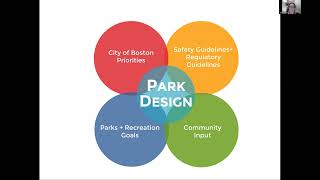
We
factor
in
city
of
Boston
priorities,
also
Parks
and
Recreation
goals,
and
we're
also
Bound
by
safety
and
Regulatory
guidelines
such
as
Ada
next
slide.
Please
go
so.
For
example,
some
of
the
city
of
Boston
priorities
are
expanding
park,
access,
addressing
equity
and
climate
resiliency,
promoting
public
health
and
building
strong
communities.
A
A
So
I
touched
on
some
of
these
earlier,
but
here's
kind
of
a
recap
of
the
scope
of
work
for
the
current
project,
we're
going
to
be
reviewing
Pathways
and
entrances
and
look
at
items
such
as
accessibility
use
and
materials.
We're
also
going
to
be
looking
at
site,
furnishings
and
lighting.
We've
also
heard
additional
comments
from
the
community
and
requests
from
Community
groups
and
all
of
that's
going
to
be
taken
into
account
as
we
move
forward
so
with
that
I
am
pretty
sure.
A
C
C
Just
for
orientation.
I,
probably
don't
need
to
spend
a
whole
lot
of
time
on
it,
but
you'll
see
this
map
oriented
this
way
throughout
the
presentation,
so
I
just
wanted
to
make
sure
we're
all
clear
on
what
we're
talking
about
so
what's
shaded
in
blue
and
green
is
the
park
that
we're
talking
about
Back,
Bay
fence
and
just
landmarks.
So
you
understand
where
we
are:
we've
got
Isabella
Stewart
Gardner
and
the
Simmons
College
Museum
of
Fine
Arts.
C
This
is
Clementi
field,
that's
the
Fenway
fire
Communications
building,
Boylston
Street,
Park
Drive
and
then
Agassi
Road
within
the
park
itself.
There's
a
number
of
landmarks
that
you
all
very
aware
of
I
already
mentioned
Clementi
field,
we've
got
the
Kelleher
rose
garden
and
the
War
Memorial,
there's
the
Victory
Gardens,
of
course,
and
then
there's
other
aspects
as
well.
That
I'll
point
out
there's
a
couple:
existing
foot,
Bridges
and
I
should
say
the
emerald
necklace,
Conservancy,
Visitor
Center
is
here,
there's
a
gate
house
next
to
it
both
historic
structures.
C
Then
we
have
a
foot
Bridge
aligned
with
Forsyth
Street
and
on
the
southern
edge
of
the
Museum
of
Fine
Arts.
There's
another
Footbridge
well
refer
to
the
Evans
way,
Bridge
or
the
location
of
the
Evans
way,
Bridge.
That's
number
17
on
the
plan
that
used
to
be
a
bridge
and
that's
one
of
the
things
we're
starting
to
study
now
in
terms
of
replacement.
For
that.
C
So
one
thing:
I,
that's
important
to
point
out
is
land
ownership
and
this
gets
a
little
complicated,
although
as
a
park
user,
you
don't
really
care.
You
know
it's
your
Park,
you
love
this
park
and
you
don't
care
if
you're
on
state
land
or
city
land,
but
it
is
important
for
the
context
of
this
project.
C
Now
that's
significant
because
to
do
any
of
the
work
that
we're
talking
about
these
pathways,
we're
crossing
or
connecting
to
DCR
facilities,
and
that
can
be
very
straightforward,
but
we
have
to
get
permission
to
access
and
have
construction
access,
but
also
if
we
were
to
do
make
improvements
because
one
of
the
access
points
or
entries
isn't
accessible.
Today
we
need
to
collaborate
with
VCR,
because
some
of
that
work
may
fall
on
their
land.
C
C
C
So
it's
I
think
it's
interesting
to
talk
about
the
evolution
of
the
park
and
I'll
just
step
back
for
a
second,
because
what
you
see
today
is
a
product
of
of
quite
a
bit
of
time.
You
know
we
think
of
the
emerald
necklace
and
you
know
it's
the
Masterwork
of
frederickle
Olmsted
and
his
firm
and
he
had
a
great
influence
on
all
aspects
of
the
emerald
necklace,
including
the
Back
Bay
fence.
C
But
what
we
see
out
there
today
is
less
a
product
of
what
he
developed
and
it's
and
that's
the
what
I'm
going
to
walk
through
in
this
next
slide,
because
there's
different
influences
over
time
to
that
have
been
shaped.
What
we
see
today,
you
know.
So
we
start
with
kind
of
the
Olmstead
period
in
the
late
1880s.
This
was
a
salt
marsh.
C
There
were
only
really
perimeter
paths,
but
then,
with
the
damning
of
the
Charles
River
and
changing
of
the
hydrology,
the
park
changed
quite
a
bit
and
then
that
led
to
an
Era
of
30
years
or
so
in
the
early
1900s,
where
Arthur
shircliffe,
a
former
Olmsted
employee,
then
shaped
the
park.
There
was
a
lot
of
Phil
brought
in
the
pathways
were
added.
The
Kelleher
Rose
Garden
was
added
the
war
memorial
was
added.
So
a
lot
of
what
you
see
is
a
product
of
that
era.
C
Some
changes
were
made
in
the
late
70s
when
another
landscape,
architect,
Carol
Johnson
Associates,
made
some
changes,
and
then
there
will
be
some
others
as
well,
and
I
wanted
to
give
a
little
bit
of
that
context
for
this
plan
that
I'm
showing
you
now,
because
what
we
find
is
particularly
as
we
go
forward.
We
want
to
know
the
origin
of
all
the
different
Pathways.
You
know
what
time
period
did
they
come
from,
so
starting
back
with
the
Olmstead
time
period?
C
Is
this
dark,
blue
or
bluish
green,
and
these
paths
that
may
not
be
in
the
exact
location
from
1879
but
they're,
very
close
from
what
we
can
tell
from
the
original
lithographs
and
carrying
on
from
plan
or
air
photo?
So
some
of
these
perimeter
paths
exist
that
were
definitely
in
those
plans.
Now
there
were
perimeter
paths
all
the
way
around
this
park
in
the
Olmstead
plan.
It's
just
that
the
park
width
and
the
roadway
alignment
has
changed
and
has
modified
some
of
that.
C
So
then
the
1955
I
know
that's
an
air
photo.
We
have
that
we
feel
fairly
fairly
confident
in
that
it
records
what
Arthur
shercliffe
did
from
1912
to
19
into
the
1940s.
So
this
orange
color
really
shows
some
of
those
paths
that
were
created
at
that
time
period
and
then
there
were
some
additions
and
modifications
with
that
Carol
Johnson
work
in
the
1970s
and
these
red
lines,
and
then
these
green
lines
are
ones
that
we
can
attribute
since
1978
or
so
so,
I
think
it's
just
interesting
context
to
understand.
C
So
then,
in
the
background
you
may
have
seen
me
and
my
staff
walking
around
the
park
many
days
documenting
the
Pathways
in
a
lot
of
different
ways,
and
this
is
just
a
sample
of
some
of
the
data
we
collected.
So
we
looked
at
all
the
pathways
for
materials
asphalt,
concrete
blue
stone,
concrete
wood
chips,
those
kind
of
things.
C
Then
we
also
keep
them
from
condition:
good
Fair,
poor,
the
width
in
feet
anywhere
from
one
foot
up
to
I,
think
14
feet,
and
then
we
actually
measured
some
of
the
slopes
to
know
if
they're
compliant
in
terms
of
ADA
or
maeb
regulations,
and
if
that's
a
longitudinal
slope
or
a
cross
slope,
and
we
didn't
differentiate
between
Boston,
Parks,
land
and
DCR,
because
we
thought
it
was
so
important
to
have
all
that
data.
So
we
have
all
of
that
now,
then
we
also
didn't
look
at
it
just
from
physical
properties.
C
That's
the
Rose
Garden
that
follows
to
the
Footbridge:
that's
at
Forsyth,
but
the
other
Footbridge
is
lit,
but
not
the
whole
path.
So
I
think
some
of
that
is
you
know
it's
an
observation,
not
a
judgment
at
this
point,
and
we
can
definitely
talk
about
what
is
the
Boston
Park's
policy
in
terms
of
lighting
parks
and
lighting,
historic
Parks,
and
you
know
how
that
influences
influences
us
going
forward.
C
We
also
collected
information
on
all
the
site
Furnishings,
so
every
bench
location,
bike,
rack,
blue
phone,
Bollard
drinking
fountain,
trash
receptacles.
We
even
collected
signs
information
on
signs
that
kind
of
thing,
so
we
have
photos
involved
in
different
types
and
we
assess
their
condition
and
here's
a
snapshot
of
a
wide
range
and
variety
of
the
site.
Furnishings
that
are
out
there.
You
would
typically
expect
a
little
more
uniformity,
but
there's
actually
rationale
behind
all
of
this.
You
know
there's
a
and
depending
where
it
is
because
this
bench
is
referred
to
as
the
shirtless
bench.
C
C
You
have
a
collection
of
different
drinking
fountains
that
I
don't
think
any
of
them
work
and
then
different
kinds
of
trash
receptacles.
So
hopefully
we
have
a
good,
comprehensive
inventory
so
that
we
can
replace
things
and
and
have
more
consistency
in
a
family
of
materials
appropriate
for
the
park.
C
So
then
to
go
a
little
bit
beyond
just
what's
out
there.
I
want
to
give
you
a
preview
of
the
kind
of
things
we're
thinking
about.
So
as
we
develop
a
actual,
we
get
a
land
surveyor
to
survey
the
site,
we'll
be
able
to
very
carefully
study
the
topography
and
where
things
are
accessible
or
not.
We
have
a
good
sense
already,
because
we've
put
smart
levels
on
the
pavement
and
know
that,
but
we
can
come
up
with
the
solutions
when
we
have
a
site
survey.
C
We've
already
had
a
contractor
fly,
an
aerial
survey
before
we
got
into
the
winter
and
then
a
land
surveyor
will
then
tie
that
to
the
ground,
doing
some
ground
surveying
and
then
we'll
have
a
survey
likely
in
February
that
we
can
use,
but
that's
also
a
little
bit
of
context
just
to
explain
this
diagram
or
the
thought
behind
this.
Each
one
of
these
dashed
boxes
are
areas
that
we
expect
that
we
will
be
studying
in
more
detail.
I'll
just
focus
on
one
for
a
second,
so
the
this
is
the
MFA.
C
This
is
Forsyth
Street,
leading
up
to
a
Footbridge
that
then
leads
to
the
Rose
Garden
or
the
war
memorial.
What's
highlighted
in
the
brighter
red,
are
paths
that
suggesting
that
paths
may
need
to
be
altered
in
alignment
particularly
closer
to
the
Fenway.
The
straight
path
from
the
Fenway
to
the
bridge
is
too
steep.
Now
a
solution
may
be
that
we
study
all
the
Alternatives.
C
The
alternatives
are
too
disruptive
and
we
have
to
get
a
variance
from
from
the
state
or
the
Alternatives
we
may
find
are
appropriate
and
still,
you
know,
don't
have
a
or
don't
dramatically
alter
the
land
or
have
an
impact
on
vegetation.
So
those
are
the
kind
of
things
we'll
study
and
that's
no
different
than
at
another.
C
So
we
have
to
anticipate
how
we
think
that
bridge
would
be
used
and
then
there
will
be
other
things,
we'll
look
at
or
adding
some
paths
potentially
or
changing
paths
in
the
victory
garden
or
and
also
we,
you
know
we
met
with
Boston
Parks
maintenance
and
they
have
concerns
about
some
paths
that
just
don't
work
with
how
they
maintain
the
site.
So
to
help
us
minimize
the
wear
and
tear
on
the
site.
We
want
to
make
sure
pads
work
with
the
way
they
maintain
it.
C
Either
snow
plowing
collect
trash
or
whatever
else
the
maintenance
activity
is
so
one
thing
as
we've
talked
to
this
came
up
at
our
first
community
sitewalk
and
we've
been
talking
to
Boston
transportation
department.
How
do
we
want
bikes
to
circulate
in
and
around
this
park?
And
this
is
one
thing
we
definitely
want
to
get
more
input
on
with
the
introduction
of
the
Evans
way,
Bridge
we're
expecting
that
this
bridge
could
be
wide
enough,
and
please
comment
on
this.
It
should
be
wide
enough
to
be
multi-use,
pedestrian
and
bike,
and
that's
an
option.
C
C
Well,
there's
two
parallel
stone
dust
paths
on
this
side
of
the
muddy
river.
One
is
considered
more
of
a
pedestrian
path
closest
to
the
river
and
closest
to
the
Fenway
informally.
It's
a
multi-use
path,
although
since
they're
both
stone
dust,
you
know
I
think
they're,
there's
not
differentiated
much,
but
there
is
a
thought
that,
because
of
olmstead's
original
idea
was
the
path
closest
to
the
Fenway
was
a
bridal
path.
It
was
called
the
ride.
The
emerald
necklace
master
plan
suggests
for
the
whole
Emerald
necklace
that
the
ride
be
converted
to
a
bike
path.
C
Now
on
our
sidewalk,
the
community
was
pretty
clear
on
this
they're
like
we're
we're,
okay
with
bikes
being
on
that
path,
but
we
really
are
in
favor
of
it
being
a
multi-use,
because
we
think
bike
traffic
should
be
slow
if
it's
in
the
park.
If
someone
wants
to
go
fast
on
a
bike,
they
should
be
on
the
road.
C
So
that's
something:
we've
talked
to
DCR
about
just
at
our
first
two
meetings.
You
know
we
haven't
really
gotten
anywhere
Beyond
sharing
information,
but
at
least
want
to
bring
that
up.
As
a
topic,
we
also
have
a
dashed
line
on
Agassi
Road
agency
Road
has
been
closed
during
the
day
during
work
hours
for
the
Army
Corps
project
and
will
be
reconstructed
when
the
project
is
done
and
we're
we've
heard
different
things
in
terms
of
how
it
will
be
put
back
in
terms
of
what
bike,
accommodation,
pedestrian
it'll,
be
sidewalks,
of
course,
for
pedestrians.
C
But
then
what
the
roadway
looks
like
DCR
was
still
discussing
that
with
the
Army
Corps
now
I
show
this
other
diagram
bike
path:
option
b,
because,
as
we
look
at
current
bike,
circulation
plans
and
studies,
they're
promoting
a
connection
between
the
Southwest
Corridor
and
the
Fenway
area,
and
that
would
go
from
Ruggles,
eventually
to
Forsyth
cross.
This
Footbridge
crossed
the
park
and
meet
up
with
Jersey
Street
in
all
those
plans
acknowledge
this.
This
bridge
is
narrow,
I
think
it's
only
four
feet
clear,
so
I
think
one
thing
we
want
your
feedback
on.
Is
you
know?
C
How
do
you
feel
about
the
current
plans
in
promoting
this
route?
Is
this
the
route
people
really
want
and
the
the
traffic
the
trips
are
really
on
both
ends
of
here
or
how
would
Evans
way
Bridge
reconstruction
influence
that
pattern?
Would
it
be
a
nice
compliment
or
an
alternative
Ben
to
add
on
to
this
idea?
How
does
that
influence
Lighting
in
the
park?
You
know
so
I
showed
you
the
analysis
earlier.
Basically,
the
highlighting
of
the
orange
or
the
yellow
is
where
there's
existing
lighting.
C
There's
a
couple
things
I'll
point
out,
as
we
met
with
the
Boston
Parks
electrician,
he
said
that
the
lighting
for
the
war
memorial
and
the
courts
is
really
old.
It's
not
LED,
it's
not
well
controlled.
It
really
would
benefit
from
being
upgraded.
So
that's
something
that
wasn't
accounted
for
in
the
original
budget,
but
it's
something
we'll
see.
Can
that
fit
in
you
know:
where
does
it
fall
in
terms
of
priorities?
So
that's
something
we're
considering.
C
A
Oh
sorry
could
I
jump
in
real,
quick
while
we're
back
on
the
lighting.
There
was
a
question
that
came
up
in
the
chat
while
we're
on
here.
That
was
just
asking
when
the
assessment
of
the
lighting
was
done
and
it
says
that
the
lights
along
the
victory
garden
and
the
O'reilly
Memorial
were
recently
replaced
with
extremely
bright
LED
lighting.
So.
C
Yeah
thanks
for
pointing
that
out,
so
we
had
done
this.
The
lighting
assessment
in
the
summer
and
I
know
the
the
walkway
of
the
victory
garden.
Those
lights
were
out
at
the
time.
I
know
they've
been
repaired
since
so,
yes,
if
anything
from
the
summer
has
changed
I
know
even
the
day.
I
did
the
lighting
assessment,
the
field
lights
weren't
on,
but
I've
seen
them
on
since
and
been
able
to
record
that
so
I
can
update
this
or
anything.
That's
changed
along
the
way.
C
One
thing
you
it's
evident
as
you
look
at
the
park
as
it
is
right
now
you
can
see
some
old
foundations
from
from
benches
that
have
been
removed
or
picnic
tables
that
have
been
removed.
You
can
see
remnants
of
other
site
Furnishings.
Looking
at
historic
photos,
you
can
definitely
see
other
bench
Styles
and
other
bench
locations
that
don't
exist
anymore
and
I.
Imagine
some
of
these
things
were
removed
because
they
were
damaged.
C
Some
may
be
because
inappropriate
things
may
have
been
happening,
but
this
is
the
time
now
again
as
we're
doing
the
pathway
project
and
that
will
have
site
Furnishings
adjacent
to
them,
to
start
to
think
about
what
is
appropriate
for
the
park
and
its
current
uses
now
and
for
the
future.
So
I'll
spend
a
little
bit
of
time
on
this
and
anxious
to
get
your
feedback
so
starting
at
the
southern
end
of
the
property
and
I
should
also
just
point
out.
C
What's
what
we
have
a
legend
on
the
right
hand
side
here,
so
the
orange
hexagon
is
an
existing
bench
to
replace
and
then
a
red
one
is
to
add
a
bench
where
there
isn't
one
today,
so
you'll
see
a
few
additions.
Now.
What
are
those
about?
I
think
there
are
some.
The
Muddy
River
Project
actually
is
having
a
I
mean
you
all.
C
This
is
obvious,
a
dramatic
effect
on
the
aesthetic,
the
visibility
and
the
use
of
the
site
and
the
view
sheds
which
in
particularly
on
the
Northern
end
here,
were
lost
because
the
phragmites
are
now
open
again.
So
I
think
there's
an
opportunity
to
take
advantage
and
really
encourage
people
to
enjoy
those
views
and
to
add
some
places
to
sit
and
that's
what
those
red
hexagons
are
orange
ones
would
be
existing
locations
to
keep,
but
if
it's
an
old
type
of
bench
to
replace
it
now,
the
victory
garden
should
talk
about
that
as
well.
C
So
there
are
some
potential
bench
locations
here.
We
can
fine
tune.
Those.
The
this
symbol
is
a
picnic
table.
There's
a
large
lawn
area
and
Community
Gathering
area
picnic
tables
have
been
removed
here
in
the
past.
So
this
is
something
we'd
want
to
get
feedback
on.
It
would
be
nice
to
have
these
here.
I
think
they
would
get
used,
but
then
we
have
to
think
will
they
get
used
appropriate
weights.
C
There
aren't
many
bike
racks
here
now,
so
you
would
have
to
think
about
what
are
the
different
destinations
there's
currently
bike
racks
at
Emerald,
necklace,
Conservancy,
anything
or
else,
but
it
would
make
sense
to
have
them
near
the
courts
or
near
the
field
house
or
at
the
victory
garden.
But
that
would
be
good
to
get
your
input.
C
Vegetation
is
a
topic
we
could
spend
a
whole
meeting
on.
Maybe
we
will
in
the
future,
but
one
thing
I
want
to
just
talk
through
in
terms
of
how
we
think
about
it.
For
this
project,
these
black
dashed
lines
with
the
tan
infill
are
areas
of
vegetation
and
then
vegetation
is
trees,
lawn
shrubs
that
we'll
be
looking
at
because
they're
adjacent
to
Pathways
and
when
I
say
look
at
it.
C
C
Of
course,
there's
going
to
be
all
kinds
of
places
in
this
large
Park
to
plant
individual
trees
and
we'll
have
to
think
about
what's
appropriate
from
what
was
done
historically,
but
you
know
what
we're
trying
to
do
now,
but
there's
big
gaps
in
some
areas
as
well
between
Clementi
field
and
the
quarks
there's
a
lawn
area
that
doesn't
really
get
used
formally
or
informally.
That
really
could
be
a
nice
separation
and
add
some
shade
here
and
then
there's
also
some
places
to
that
shrubs
can
be
added.
C
This
red
oval
is
a
bank
on
the
muddy
river
right
near
that
Northern
foot
Bridge,
that's
fairly
bare.
That
would
benefit
from
some
planting
and
then
vegetation
management.
These
red
bars
are
places
where
shrubs
likely
shrubs
from
the
shircliff
era
are
overgrown,
overhanging
the
pathway
and
causing
either
pedestrians,
bikes
or
even
maintenance
vehicles
to
go
off
the
pathway,
and
you
see
the
ruts
in
the
wear
opposite
these
these
shrubs,
as
they're
changing
pedestrian
patterns.
C
The
other
thing
I
wanted
to
point
out
with
some
of
the
Army
Corps
work
in
some
areas
being
closed
off,
the
grass
has
been
able
to
grow
and
some
areas
have
actually
turned
into
like
a
Goldenrod
Meadow.
So
we'd
like
to
get
your
input
on
that
you
know.
Is
that
a
good
thing
where
you
know
where
it's
happened
a
little
bit
by
chance,
but
here's
an
opportunity
to
reduce
the
use
of
fossil
fuels
in
terms
of
mowing
there's
also
a
a
benefit
in
terms
of
pollinators.
C
But
then,
let's
talk
about
the
Aesthetics
and
the
potential
issues
in
terms
of
trash
or
you
know,
whatever
else
it
may
be
there
is.
There
are
a
number
of
pieces
of
art
within
the
park
and
Lauren
mentioned
the
different
stakeholders.
We've
talked
to.
She
met
with
the
Arts
commission
and
they've
already
done.
C
Some
work
at
the
O'reilly
Burns
obviously
was
recently
moved
to
the
park
again
and
it's
we
have
the
Carol
Johnson
report
from
the
1970s
and
they
point
out
the
settlement
in
the
bell
at
that
time
and
I
know
at
our
community
walk
in
October
someone
said:
have
you
seen
the
Bell
the
foundation
there's
something
going
on
there,
because
it's
not
level.
So
it's
like
the
same
observation
from
1978.
C
A
C
D
D
D
D
D
D
D
D
So
here
are
some
other
sure,
Cliff
Bridges,
the
the
one
on
the
top
left
is
the
middle
Bridge.
It's.
What
is
now
the
has
been
replaced
and
oh
actually,
that's
the
northernmost
bridge,
and
then
the
next
one
is
the
middle
Bridge,
the
one
that
aligns
with
the
the
crosswalk
behind
the
MFA
near
the
parking
lot
and
then
sure
Cliff
also
designed
the
the
Charles
River
Esplanade,
and
there
are
five
bridges
that
are
very
similar
in
design
that
are,
that
were
also
sure
clip
designs.
D
D
D
So
next,
please
and
the
last
two
slides
are
precedent,
Bridges
and
really
it's
a
mixture
of
all
types
of
bridges,
all
styles,
all
different
materials.
So
at
this
point
we're
still
in
the
brainstorming
stage-
and
you
know
we're
just
we're,
keeping
our
mind
open
mind's
open
as
to
as
to
what
the
possibilities
are.
So
here
here
are
a
few
examples:
the
shirt,
Cliff
Bridge,
one
of
the
circle
of
bridges
on
the
Esplanade
top
left.
D
D
Then
we
have
North
Bank
bridge
in
in
Cambridge,
with
the
zaken
bridge.
In
the
background
and
I
included
this
one
on
the
middle
bottom
row.
It's
it's
kind
of
exciting.
It's
just
down
the
road
in
in
Brookline,
the
Carlson
City
Bridge
is
being
restored
after
a
17-year
long
wait
and
it
should
be
open
to
the
public
in
early
spring
of
this
year.
D
D
C
C
A
Going
back
through
as
I'm
as
you're
talking
Kyle
to
see
if
there
are
others
that
I
missed
before
we
jump
into
any
new
ones
and
I
think
I
was
able
to
respond
to
most
of
them.
So
I
know
that
it
looks
like
we've
got
a
hand
raised.
Marie
has
her
hand
raised
Christine.
Could
we
unmute
Marie
so
that
she
can
jump
in.
E
Yes,
I
have
one
comment
and
one
question:
I
guess
so
the
thing
that
I
feel
most
strongly
about
and
I
know
that
this
is
not
something
that
has
only
one
answer,
but
I've
been
looking
at
the
open
space
plan,
the
last
open
space
plan
for
the
Fenway
and
asking
some
questions
as
to
what
the
updated
numbers
will
be
and
I'm
reminded
that
the
Fenway
has
a
very
low
ratio
of
open
space
for
a
hundred
residents.
It's
about
half
of
the
city's
average
with
most
residents
living
in
really
small
apartments.
E
The
park
system
is
really
the
resource
for
those
of
us
who
live
here
to
enjoy
a
range
of
activities,
whether
it's
path
of
things
like
gardening,
a
stroll
through
the
park
going
jogging.
It's
not
like.
We
have
a
myriad
of
choices
when
we
want
to
go
interact
with
park
space,
so
I
have
to
say
my
primary
concern.
Hearing
this
presentation
is
the
discussion
about
our
resource.
E
You
know
our
place
to
go
to
get
away
from
the
rest
of
the
city
and
really
significant
traffic
becoming
a
bike
Corridor,
and
some
of
the
reasons
that
I
would
say
that
is
there
is
the
DCR
master
plan,
whether
they're
committing
to
it
or
not.
That
does
have
a
plan
to
put
bicycles
on
the
Parkways.
There
is
a
plan
for
agassi's
road
that
contained
bike
paths,
which
would
connect
bicyclists
from
the
East
to
the
West.
E
I
walked
to
Kenmore
Square
every
day
now
to
take
care
of
someone
and
I
continue
to
observe
on
Boylston
Street,
how
the
Boylston
Street
bridge
on
the
side
closest
to
O'reilly
I,
don't
know
what
direction
that
is.
It's
used
heavily
by
Walkers
people
who
stop
and
look
out
over
the
bridge,
so
I
know
that
this
isn't
in
your
project,
but
the
top
of
Boylston
Street
has
been
designated
I.
Think
by
the
docker
project.
E
So
I'd
like
to
caution
and
recommend
to
any
degree
possible
to
work
with
the
DCR
as
to
how
like
traffic
IR,
speed
like
traffic,
can
be
worked
out
to
to
go
on
to
the
Parkway
and
the
one
question
that
I
have
is
regarding
the
stone
dust
pass
and
materials
and
whether
there's
been
any
talk
about
whether
they're
a
stabilized
stone
dust
materials
that
are
being
contemplated
at
this
point
in
time.
Thanks
very
much.
A
Thank
you,
Marie
before
Allison
I,
see
your
hand
is
up
before
we
jump
into
that.
There's
a
comment
here
that
Kyle
I'm
going
to
read
out
that
kind
of
ties
into
what
what
Marie
was
saying
and
the
question
is
maybe
you
could
address
some
of
this
is:
is
there
any
barrier
as
to
why
this
bridge
would
not
be
built
to
the
largest
capacity
possible?
This
is
a
huge
Corridor
connection
to
and
through
the
park,
the
Boylston
Street
side
is
DCR
right.
C
F
F
A
And
so
Allison.
Thank
you.
I
I
appreciate
all
of
those
comments
and
I
should
have
explained
that
during
the
time
frame
slide.
But
we
absolutely
wholeheartedly
agree
with
you
that
this
project,
even
before
we
added
in
the
World
War
II
and
the
Evans
way
bridge
and
O'reilly,
was
already
looking
at
more
than
three
meetings,
because
it
is
so
important
and
there
are
so
many
constituents
that
we
need
to
talk
to.
A
So
we
definitely
will
have
more
than
three
we're,
not
sure
exactly
how
many
we're
gonna
have
yet,
because
we
need
to
make
sure
that
we
are
talking
to
the
right
people
and
talking
about
specific
things.
We
may
end
up
having
a
specific
meeting
about
the
bridge.
We
might
have
a
specific
meeting
about
World,
War
II,
so
we're
trying
to
think
about
Gathering
a
lot
of
information
as
a
whole
and
then
we
might
break
it
up
into
more
digestible
chunks
as
we
move
forward.
A
C
Yeah
you're
comment
about
this.
Footbridge
is
an
important
one,
because
that
slope
is
very
Steep
and
that's
probably
the
biggest
challenge
in
terms
of
some
of
the
accessibility
improvements
that
we
will
study
and
on
our
sidewalk.
The
community
pointed
out
this
area
particularly,
and
they
said
you
know,
Crossing
from
the
sidewalk
at
the
MFA,
it's
difficult
to
see
for
a
pedestrian
to
be
seen
by
a
driver
on
the
Fenway
because
of
the
parallel
parked
cars
and
the
curve,
and
then
once
you
do
cross,
then
you
have
that
slope
and
navigate.
G
B
F
H
You
go.
Thank
you
hi,
okay,
so
I've,
you
know
been
a
part
of
this
park
for
longer
than
most
of
you,
guys.
I,
know
and
I
think
it's
important
to
distinguish
whether
we
are
obligated
to
provide
transportation
to
or
through
the
park
and
what's
the
VA.
What's
the
difference
between
going
to
the
park
and
through
the
park
right
now,
the
the
major
pathway
between
Forsyth
and
coming
out
on
Jersey
Street
is
Northeastern
students.
H
H
H
H
It's
the
only
place
where
you
can
really
find
quiet
a
place.
So
when
the
bridge
gets
re-rebuilt,
I
I
just
cannot
possibly
see
the
need
to
speed
large
volumes
of
people
and
bicycles
through
that
area
when
the
outside
perimeter
is
so
near
and
and
it's
an
acceptable
place
that
outside
pathway,
stone
dust
path,
part
of
its
asphalt
along
the
Fenway
and
I-
think
there's
also
the
question
or
a
plan
about
making
that
outer
path
asphalt.
H
H
It's
just
what
I,
what
I
wanted
to
say
because,
as
you
know,
any
place
where
you
can
get
somewhere
sooner
by
cutting
through
somewhere
is
is
going
to
be
the
one
the
worn
place
when
there's
accessibility,
that's
just
nearby
and
is-
is
formalized
around
the
outside
of
the
park.
Let's
not
carve
up
the
park
for
everything
that
has
wheels.
A
I
Hi,
thanks
for,
let
me
speak.
This
is
great
I've,
been
on
the
other
meetings
and
I've
also
lived
here
for
over
30
years
and
walked
that
Park
pretty
much
daily
and
love
it
I
just
want
to
Echo
it's
pretty
much
the
sentiments
that
Brady
just
said
about
the
important
and
is
also
Marie
the
importance
of
this
being
a
passive
Park.
I
As
you
know,
the
Fenway
building
boom
is
insane
or
the
densest
place
on
the
planet.
Right
now
and
to
have
this
passive
space
is,
is
so
precious
and
just
to
enjoy
the
beautiful
ash
tree.
Etc
I
also
agree
that
we
should
really
make
a
lot
of
progress
with
the
city.
Now
is
the
time
to
get
these
bike
paths
on
the
roadways,
because
that
will
force
traffic
to
slow
down,
which
it
should,
because
these
are
Parkways
and
they
were
designed
for
residential
area
not
not
pass
through.
I
So
I
think
those
two
things
dovetail
very
well
together
and
I
think
there's
plenty
of
available
space
What
with
the
Agassi
Road
and
the
fence
and
Park
Drive
for
the
bike
Lanes
to
be
fully
developed
and
supported.
I
think
everybody
will
support
them.
So
that's
kind
of
about
the
bikes
with
the
bridges.
Thank
you
Elena
for
getting
on
this
and
showing
those
historic
photos
was
fantastic.
I
B
I
So
the
actual
structure
of
the
sides
of
the
fence
and
it's
along
with
the
size
of
the
bridge
I,
would
really
request
that
we
keep
it
to
the
minimum
and
make
it
pedestrian
focused
and
I
pretty
mentioned
how
people
are
really
working
together.
Now,
it's
a
really
respectful
environment,
I'm
really
happy
to
say
that
when
a
cyclist
goes
by
they're,
usually
looking
at
the
surroundings
and
loving
it
and
going
at
a
reasonable
rate
and
walking
their
bike
over
the
bridge,
but
mostly
people
bike
around
the
park
is
my
experience
living
here.
I
The
third
thing
I
want
to
just
comment
on
was
the
furniture
and
the
open
space
area,
The
Meadows,
I
love.
The
idea
of
maybe
some
kind
of
naturalness
being
left
in
here,
because
it
kind
of
is
a
throwback
to
Homestead
and
getting
rid
of
those
fragmites
praise.
The
Lord,
thank
you,
you
know
to
have
a
low-level
kind
of
nature
scene
is,
would
add
to
the
passivity
and
the
calming
effect
of
the
place.
So
you
have
the
a
meadow
experience
you
have
the
public
garden.
I
I,
don't
wouldn't
add
any
tables
there
for
known
police
reasons
in
the
past.
That
we've
struggled
with
I
would
keep
the
bike
racks
to
the
entrance
exits.
Like
you
mentioned
earlier,
around
Clemente
Park
and
maybe
just
limit.
You
know
yeah.
There
was
a
second
space
too,
but
I
think
it's
moving
along
great
and
those
are
my
comments
and
observations.
Thank
you.
J
J
What
I've
noticed
at
least
by
the
lower
end
of
the
gardens,
is
that
if
it
was
just
grass,
it's
like
one
of
those
places
where
we
see
people
Gather
in
the
spring
and
they
show
up
and
they
hang
out-
and
you
know
in
the
old
days
until
the
phragmites
got
up
and
then
that
that
would
change
that
scene.
I
think
that
a
lot
of
people
would
use
that
open
space
as
as
passive
open
space
just
to
sit
and
have
picnics
buy
by
the
muddy
river
and
be
able
to.
J
If
you
think
about
this,
the
burn
statue
is
now
going
to
be
open.
You're
going
to
be
able
to
see
all
the
way
across.
So
a
lot
of
our
old
issues.
I
think
kind
of
disappear
with
that
and
I
would
like
to
I'm
not
against
the
idea
of
a
meadow
but
also
I.
Think
that
I've
seen
people
use
that
when
it
was
grass
and
also
should
think
that
maybe
that's
a
nice
passive
use
as
well,
then
I
wanted
to
comment
really
about
Evan's
way.
Bridge
I
think
we
have
to
remember
that.
J
There's
other
development
going
on
here,
Samuels
and
Associates,
have
and
are
are
hoping
with
their
1400
Boylston
project
to
expand
the
connection
to
the
main
Bikeway
across
their
property
as
far
as
it
goes,
which
would
bring
it
up
to.
You
know
the
end
of
the
Star
Market
property,
and
hopefully
the
city
will
continue
that
connection
so
that
it
comes
up
and
meets
up
with
the
Park
Drive
area.
So
we
could
have
a
connection
there.
J
I
really
am
worried
about
running,
creating
a
path
that
bicycles
can
fly
through
to
cut
off
like
60
seconds
a
time
on
their
commute.
When
really,
we
should
probably
be
looking
at
how
we
can
make
the
crossings
that
bikes
can
get
up
to
the
Samuel
Associates
connection,
so
they
can
get
on
the
main
bike
path
and
then,
when
that's
all
completed,
they'll
be
able
to
get
on
into
town
and
they're
very
Safe
Way
without
traffic
being
in
their
way,
and
people
can
write
as
they
like,
but
on
the
bridge
itself.
J
I
think
it's
really
important
that
we
encourage
some
kind
of
traffic
calming
for
bicycles,
high-speed
bicycles,
going
through
those
pedestrian
areas,
as
we
saw
when
we
did
our
walk
through.
We
were
just
standing
on
right
there
by
the
ENC
building
and
you
watch
a
wheelchair
trying
to
come
through
that
bridge
in
a
bicycle,
completely
cut
them
off
and
run
over.
J
You
know
through
that
area
it
was
like
the
it
couldn't
happen
at
a
better
time
to
show
what
the
problem
is
and
I
don't
know
if
it's
as
simple
as
Bollard,
so
that
a
bicycle
has
to
slow
down
and
either
get
off
and
or
at
least
maneuver.
So
they
have
to
slow
down
to
three
miles
an
hour
so
they're
at
a
walking
pace.
J
Something
like
that
might
be
okay
for
Crossing
into
the
in
the
park,
but
the
park
is
designed
to
be
passive
and
it
really
is
designed
for
people
to
be
able
to
go
there
and
just
walk
their
dog
or
just
walk
themselves
and
enjoy
looking
at
the
Ducks.
You
know
that's
what
you're
there
to
do
and
that's
our
only
place
to
go.
Do
this,
and
this
is
a
really
big
community,
and
this
is
our
only
open
space.
I
think
that's
why
we
are
trying
to
protect
it
from
any
new
shadows
in
other
projects
and
I.
J
J
It's
it's
fine
as
long
as
they're
respectful,
but
if
you
make
that
a
Zone
where
hey
I'm
going
to
fly
across
Evans
way,
bridge
and
I'm
going
to
fly
directly
across
the
field,
like
you
know,
you're
on
a
bicycle,
you
can
do
anything.
You
want
I
think
you're
going
to
create
a
lot
of
issues
if
you
do
that,
like
I,
don't
know
where
those
paths
are
going
to
go
and
if
a
straight
line
is
always
the
best
line.
J
I
think
a
lot
of
people
will
take
the
best
line,
so
let's
just
keep
them
kind
of
like
around
the
perimeter,
and
hopefully
that
would
keep
the
calmness
of
our
Park
together.
Thank
you.
So
much
guys,
I
don't
want
to
be
running
down
on
you
guys,
I'm,
not
at
all
it's
a
fantastic
project.
It's
really
exciting,
to
see
this
happening,
and
you
know
thank
you
so
much
for
actually
doing
this.
Thank
you.
A
G
Yeah
unmuted
I,
just
put
almost
all
my
comments
in
the
in
the
chat,
but
just
in
case
I
didn't
get
called
on,
but
I
think
I'm
going
to
disagree
with
a
bunch
of
people
who
live
along
it
because
the
whole
Emerald
necklace
is
in
fact
what
I
would
call
recreational
Transportation
Corridor
and
it
served
originally
equestrians
and
now
bicyclists.
In
the
same
way,
people
ride
it
not
just
to
go
places
but
to
ride
along
the
emerald
necklace,
because
it's
a
beautiful
place
to
bike
I
mean
I
commute
on
it.
G
The
idea
was
we'll
go
from
Castle
Island
to
the
Blue
Hills,
which
is
13
miles,
but
most
people
don't
do
that
they
go
shorter
distances,
they're,
probably
more
pedestrians
using
it
as
a
purely
recreational
rather
than
connecting
place,
but
a
lot
of
bicyclists.
It's
a
destination
place
to
go
and
they
Don't
Ride
real
fast.
G
If
it
rains
the
water
hangs
out,
because
it's
flat,
which
is
good
when
it's
dry,
but
when
it's
wet,
it's
not
good,
it
has
edgings
which
are
bricks
or
pavers,
and
they
are
uneven
and
stick
up
and
if
you're
avoiding
a
puddle,
you
often
might
walk
into
one
of
them,
because
they're
Rolling
Water
back
from
draining
down
the
hill,
so
pavement's
important
there.
The
other
thing
I
wanted
to
say
is
that
pads
that
get
a
lot
of
foot
traffic
need
to
be
sort
of
wide.
G
My
feeling
is,
the
path
needs
to
be
wide
enough
to
tube
pairs
of
pedestrian
walking
side
by
side
going
in
opposite
directions
can
pass
each
other
which
that
means
which
means
around
10
feet,
at
least
and
maybe
12.,
and
that's
just
for
walking
not
walking
fast,
not
doing
anything
else.
It's
just
walking
where
you
don't
have
to
constantly
get
out
of
the
way
foreign.
A
K
Great
yeah
hi
everyone
I
just
want
to
flag
a
few
things,
but
I
first
want
to
say
just
thank
you
for
holding
these
sessions
and
for
doing
a
lot
of
really
thorough
work
on
this
area.
I
think
it
will
benefit
all
of
us
in
the
shared
space.
So
we
appreciate
it
so
with
so
much
attention
going
into
this
space.
K
I
want
to
flag
a
few
areas
that
I
would
love
to
see
more
attention
if
possible
and
I
think
we've
discussed
some
of
them
Kyle
and
Lauren,
but
the
first
and
most
interesting
or
pressing
to
me
is
11
on
the
map.
It's
the
mother's
rest
site.
I
know:
we've
talked
about
it,
but
for
people
who
don't
know
that's
a
hillside
that
has
seen
a
tough
past
decade
and
it's
had
a
lot
of
really
difficult
erosion
and
things
have
struggled
to
grow
there
other
than
a
few
sparse
invasives.
K
But
there
are
a
bunch
of
beautiful
oak
trees
with
you
know,
really
established
canopy
there.
So
at
the
emerald
necklace
Conservancy,
which
is
where
I
work
and
what
I'm
representing
we
want
to
think
about
how
to
protect
those
trees
and
restore
that
soil
and
I
know
that
you
all
already
have
so
much
on
your
plate,
but
any
more
attention
that
can
be
dedicated
to
that
area
would
be
really
appreciated.
I
know
it's
something:
Elena
has
been
an
advocate
for
as
well,
so
yeah
and
I'm
happy
to
continue
conversations
about
that.
K
I
think
this
is
a
really
good
time
to
be
capitalizing
on
those
types
of
things
so
I
appreciate
it.
The
last
little
area,
I
think
Parker
may
have
mentioned
it
in
the
chat,
but
with
attention
going
into
charlesgate
and
the
potential
changes
at
the
North
part
of
the
Back
Bay
fence,
I
think
that'll
be
an
important
area
to
keep
an
eye
on
I'm
sure
you
all
are
aware,
but
yeah.
A
Thank
you
Jack
and
yeah
you're,
absolutely
right.
The
coordination
with
DCR
on
this
is
going
to
be
huge,
and
we've
already
had
a
couple
of
really
great
meetings
with
them.
So
I
have
a
feeling
that
it's
going
to
be
a
really
positive
collaboration.
So
that's
that's
a
really
good
thing
and
thank
you
for
pointing
out
those
other
areas
to
focus
on
too
Kevin
I
think
you've
got
your
you've.
You've
had
your
hand
raised
you're
being
very
patient.
Thank
you.
So
much.
L
Thanks
so
much
Lauren
and
everybody
I
I
really
appreciate
this
process
as
part
of
the
walk
through
and
thanks
for
listening
so
carefully.
To
many
many
many
comments
from
many
people
tonight
and
previously,
a
couple
of
quick
additional
comments
for
here
here
on
the
Evans
bridge.
I
feel
very
very
strongly
about
this,
as
a
piece
of
if
I
feel
well
environmental
justice
for
the
city
to
restore
that
bridge,
the
pathway,
the
raised
pathway
south
of
Clementi
field
terminates.
L
Thank
you,
iterminates,
oddly,
at
the
basketball
courts
and
for
a
person
you
know
a
pedestrian
or
with
a
dog
walker.
You
end
up.
If
you
want
to
stay
on
a
path
you
have
to
sort
of
walk,
very,
very
close
to
where
active
play
is
taking
place,
and
it
would
be
wonderful
if
that
pathway,
somehow
more
naturally
connected
to
the
other
Pathways
rather
than
terminating
at
the
basketball
courts.
L
L
This
is
a
justice
issue
for
people
with
disabilities,
particularly
Mobility
disabilities,
and
it
really
needs
attention
now
that
that,
now
that
the
phragmites
are
gone
and
all
that
beautiful
planting
is
in
place,
this
is
going
to
be
a
premier
area
for
walking
through
the
this
section
of
the
park
and
really
should
be
maximized.
I,
don't
I,
don't
have
a
specific
recommendation
for
the
for
the
surfacing
of
that,
but
it
should
be
it.
It
should
be
erosion,
proof
and
accessible
to
all.
L
I
have
a
comment
about
lighting
I'm,
not
sure
how
people
are
thinking
about
lighting
I
saw
the
the
key
was
more
about
sort
of
bright
versus.
Not
bright,
bright
is
not
always
the
best
right.
You
you
want
the
park
to
be
safe
and
passable
I
find
the
overly
bright
LEDs
that
have
been
recently
installed
to
be,
in
fact,
blinding
and
I
actually
feel
less
safe
in
that
blinding
light,
because
I
I
really
can't
see
where
I'm
going,
because
the
lights
are
so
in
your
eyes
and
blinding
so.
L
I
just
want
some
thought
to
the
nature
of
lighting
both
for
environmental
quality
and
safety,
and
you
know
overall
appropriateness
and
then
no
one's
mentioned
this,
but
I
know
there
was
advocacy
a
number
of
years
ago
for
a
Fenway
dog
park.
I'm
curious,
if
that
is
dead
in
its
tracks,
because
of
considerations
about
the
emerald
necklace
I
was
just
curious,
whether
that
has
any
life
in
this
discussion.
That's
it.
A
Foreign,
thank
you
Kevin.
Those
are
all
really
good
points
and
in
terms
of
the
the
comments
that
you
had,
one
of
the
things
that
and
Kyle
I
don't
know
if
you
want
to
jump
in,
we
talked
with
the
Army
Corps
about
that
pathway,
specifically
that
you
were
mentioning
behind
the
Victory,
Gardens
and
sort
of
what
they
were
still
responsible
for
doing.
A
So
it's
definitely
a
pathway
that
we're
looking
at
and
I
know
that
with
the
work,
that's
happened
on
the
muddy
river,
we're
trying
to
get
a
hold
of
some
of
the
new
flood
flood
elevation
maps
and
trying
to
kind
of
see
if
any
of
the
changes
that
they've
done
are
going
to
help
with
some
of
that
flooding.
That's
there.
So
that's
something
that
we
definitely
are
looking
at
and
I.
Think
in
terms
of
your
comment
about
lighting,
so
you're,
absolutely
right.
A
A
You
know
where
that
came
from
and
where
that
went,
and
so
maybe
at
our
next
meeting,
I
can
fill
you
in
on
what
I
find
out
from
that
awesome.
Okay,
wonderful!
Well!
Thank
you.
I
appreciate
all
of
the
great
comments,
oh
Kevin.
That
will
be
great
if
you
do
feel
free
to
send
that
over.
Does
anybody
else
have
any
thoughts
or
any
comments,
while
we're
here.
E
Oh
great
does
that
work?
Okay,
thanks,
Kevin
comment
made
me
realize
that
right,
where
the
number
eight
is
is
a
pathway
in
the
Victory
Gardens
that
was
redone,
gosh
I
want
to
say
it
was
maybe
eight
years
ago
because
of
how
it
flooded
as
it
approached
the
stone
dust,
Path
Road
and
it's
currently
still
getting
water.
So
I,
don't
it's
because
rating
that
is
also
occurring
as
part
of
your
project.
C
C
C
E
That's
great
and
I
think
the
the
last
comment
that
Kevin
reminded
me
of
is
having
had
to
help
arborists
get
out
of
the
mud
as
they
were,
trying
to
drop
us
wood
chips.
It
makes
me
think
it's
partly
the
partly
raising
it
and
stabilizing
it
so
that
these
really
heavy
equipment
Vehicles
can
get
in,
but
also
looking
at
what
their
turn
radius
needs
would
be.
E
A
Thanks
Marie
and
those
that's
a
really
good
point
about
the
maintenance
vehicles
and
like
Kyle
was
saying:
we
met
our
maintenance
folks
out
on
the
site
and
did
a
walk
with
them
and
specifically
looked
at
some
of
the
areas
where
they
you
know,
they're
really
having
challenges,
because
they
don't
want
to
drive
on
the
lawn.
They
don't
want
to
tear
up
the
corners.
They
want
to
do
the
right
things
while
being
able
to
get
to
where
they
need
to
to
maintain
or
to
drop
wood
chips
or
to
get
to
light
poles
or
whatever
it
is.
A
F
Hi,
thank
you
Lauren
and
thank
you
for
answering
everybody
or
responding
to
so
many
different
points
of
view.
I
just
wanted
to
again
talk
about
the
process
a
little
bit
more.
You
said
the
next
meeting
is
February
16th
and
I.
I
know
there's
so
many
different
sub
topics
with
this
project
and
there
was
a
slide
that
started
to
talk
about
shrubs
and
trees,
but
we
didn't
really
get
into
that
tonight.
So
I
I,
don't
know
of
any.
F
If
there's
going
to
be
any
tree
loss
with
some
of
the
pathway
improvements,
but
it
is
something
that
I
think
people
would
be
interested
in
and
talking
about
more,
and
so
it's
definitely
something
to
to
keep
in
mind.
I'm
I'm
glad
there's
been
30
people
Plus
on
the
meeting,
but
I
was
wondering
about
the
Outreach,
because
I
didn't
find
the
meeting
on
the
city
website
or
on
the
parks
department
page.
A
H
F
B
A
A
Other
question
I
have
is
I,
have
a
I
have
a
list
as
well
and
try
to
get
it
out
to
organizations
that
also
help
get
word
out
to
people.
If
there
are
people
or
organizations
that
you
know
of
that,
I
should
make
sure
on
my
list
to
be
able
to
help.
Get
that
word
out
too.
I
would
love
to
hear
about
it
just
to
make
sure
we're
not
missing
people
as
well.
Okay,.
A
F
A
M
Okay,
great
I
put
a
number
of
comments
in
the
chat,
so
I,
don't
I,
don't
want
to
repeat
them,
and
but
it
you
know,
it's
wonderful
to
spend
part
of
an
evening.
Talking
about
the
Fenway
I
mean
what
better
but
I,
guess
I
guess.
My
observations
were
based
on.
You
know
having
taken
the
tour
with
the
emerald
necklace
director,
Karen
Monty
brodeck
yep
in
the
spring
as
part
of
the
Olmsted
Bicentennial
conference,
and
then
what
I
did
because
we
were
also
visiting
fairstead.
You
know
I
decided
to
walk.
M
You
know
bicyclists
are
always
going
to
find
a
way
to
go
where
they
want.
Many
of
them
will
so
I.
Think,
probably
the
name
of
the
game
is
to
give
them
as
many
safe
Alternatives
as
possible
and-
and
you
know,
I
think
that
probably
involves
you
know
creating
protective
bike.
Lanes
you
know
along
along
the
roadways,
and
then
you
know,
but
but
trying
to
ban
bikes
from
certain
areas
is
probably
something
you
know.
M
You
know
designed
with
the
consistent
theme-
and
you
know
just
you
know
us
a
sense
of
you
know
the
sort
of
pastoral
sense
that
Olmsted
intended
and
so
I
think
you
know
when
you,
when
you
do
new
bridges
in
the
landscape.
You
know
I
think
you
have
to
you
have
to
keep
your
eye
on
that
as
a
Paramount
factor.
M
In
choosing
you
know
what
what
kind
of
design
that
you
want
to
use
so
that
you
have
this
sense
of
coherence
and
not
a
sense
of
you
know,
sort
of
a
sort
of
a
dissonance
in
terms
of
the
design
and
the
feel
of
the
landscape.
So
so
so
my
comments
were
all
based
on
that
experience
last
spring
and
this.
So
this
is
great.
A
Well,
thank
you.
Alan
I,
appreciate
that
and
I
appreciate
those
thoughts
of
having
been
through
that
that
walk
too.
It's
really
nice
to
get
that
perspective
on
it.
So
thank
you
and
thank
you
for
everything
you
put
in
the
chat
as
well.
Kyle
I,
don't
know
if
you
had
anything,
you
wanted
to
jump
in
on
that.
One.
C
A
Absolutely
and
one
thing,
Alan
I
was
just
looking
back
at
the
notes.
I
was
taking
while
you
were,
while
you
were
talking
and
when
you
were
talking
about
the
consistency
from
sort
of
park
to
park
throughout
the
neighborhoods.
It's
one
of
the
things
that
Kyle
and
I
have
talked
about
in
terms
of
the
emerald
necklace
master
plan
that
we've
been
that
you
know
from
years
ago
that
we've
looked
at
as
well,
and
there
are
a
lot
of
comments
like
that
throughout
the
master
plan
in
terms
of
site,
furnishings
and
other
things.
A
M
I
would
just
add
with
regard
to
that
in
the
site
furnishings
and
things
like
benches
and
water
fountains
I
mean
you
know.
With
this
being
such
a
special
landscape,
I
mean
it's
easy
to
default
when
you're
doing
parks
and
and
Greenway
corridors
you
just
sort
of
you
know.
Folks
in
the
profession,
are
familiar
with
Suites
catalog,
which
you
go
in
and
you
order
your
benches
from
or
you
order
your
water
fountains
Farm
or
you
order
your
your
bike,
racks
from,
but
I
think
you
know
this.
M
A
Yeah
I
agree
and
Alan
I'm,
not
sure
if
you
noticed
recently
recently,
it
feels
recently
over
the
last
few
years.
Kyle
and
I
also
work
together
on
the
Jamaica
Pond
Pathways
project
and
one
of
the
things
that
we
did
there
was
actually
to
take
and
create
cast
or
pattern
boards
for
the
castings
for
the
benches.
That
are
there
because
we
didn't
have
those
anymore,
and
so
that
was
one
of
the
things
that
we
did
do,
and
so
we
do
have
those
pattern
boards.