►
Description
Additional information at
https://lims.minneapolismn.gov
A
A
Members
of
the
board
may
participate
remotely
by
telephone
or
other
electronic
means
due
to
the
local
public
health
emergency
novel
coronavirus
pandemic,
declared
on
march
8
march
16
2020
pursuant
to
the
provisions
of
minnesota
statute,
section
13d
021,
so
we
have
four
presentations
to
date
and
we're
starting
with
the
upper
harbor
terminal,
the
dowling
avenue
north
parkway
33rd
avenue
north
with
alexander
cato
nathan,
costner
ahmad
o'mare,
and
I
think
it's
clara
schlettling.
I
hope
I'm
pronouncing
that
right
and
chris
bauer,
so
you
guys
take
it
away.
B
Hey
everybody
just
getting
my
video
set
up
today.
It's
it's
going
to
be
a
little
bit
of
a
smaller
group.
It's
going
to
be
myself,
I'm
out
of
credo
transportation
planner
with
the
city,
minneapolis
engagement,
lead
for
the
infrastructure,
and
then
I'm
joined
by
our
great
engineer
and
friend,
chris
bauer,
chris
I'll.
Let
you
introduce
yourself
real
quick
to
everyone.
B
A
B
B
I'll
try
to
move
through
this
as
quick
as
I
can
to
give
folks
time
to
ask
questions,
I'd
love
to
hear
how
you
all
feel
about
this,
so
we'll
just
hop
right
into
it.
This
is
the
30
concept
we
are
going
to
our
open
house
next,
tuesday
and
yeah,
so
this
is
you're
seeing
it
fresh
before
we
go
here
and
then
we're
gonna
go
to
layout
in
october.
So
this
is
moving
along
quickly
and
thank
you
for
having
us
today.
B
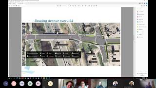
This
is
the
infrastructure,
the
upper
harbor
terminal.
The
starting
point
is
dowing
at
lindale.
That
goes
all
the
way
in
across
downwind
across
the
bridge
into
the
site.
We
have
phase
one
of
the
uht
parkway
and
then
we
also
have
the
secondary
access
at
33rd
avenue
and
north.
So
it's
it's
over
a
mile
infrastructure.
B
If
you
were
to
walk
all
this
all
right
if
you're
moving
fast,
maybe
30
minutes,
but
I
think
with
all
the
exciting
things
that
it
might
take
you
an
hour
and
a
half
or
longer
so
there's
there's
a
lot
of
content.
There
we've
been
engaging
over
the
last
year,
some
of
the
biggest
pieces
around
our
engagement
are
really
touched
on
how
do
non-motorists
get
to
the
site
safely,
so
how
to
cyclists,
how
to
pedestrians,
how
to
scooter
riders?
B
How
do
people
in
wheelchairs,
how
do
people
that
are
not
taking
vehicles,
get
there
and
also
transit
as
well?
We
all
know
the
barrier
that
exists
with
I-94,
and
so
we've
really
tried
to
provide
multimodal
options
that
are
safe,
reliable
and
really
connecting
to
the
broader
network
as
well.
I'm
going
to
skip
the
engagement
slides
because
I
kind
of
just
talked
through
that
those
are
there
if
you
want
to
review
them.
You
all
have
this
presentation,
I'm
just
going
to
hop
into
upper
dowling,
so
this
is
kind
of
the
first
piece
of
infrastructure.
B
We
call
it
upper
dialing
because
it's
on
the
western
side
of
the
bridge,
it's
at
a
higher
elevation.
This
is
the
intersection
of
linda
lab
in
the
north,
and
you
can
see
that
we
have
a
shared
use
path:
treatment
on
the
south
side
of
the
roadway,
10
foot
width.
We
have
two
vehicle
travelings.
This
says
11
they're,
actually
10
foot
traveling,
so
I
apologize
for
the
the
graphic
error,
tight
timelines,
trying
to
get
things
to
you
as
soon
as
possible,
but
these
are
10
foot
travel
lanes.
We
also
have
a
six
foot
sidewalk.
B
B
This
is
a
high
volume
roadway
about
15
000
vehicles
a
day
and
so
in
those
type
of
situations
we'd
like
to
separate
motors
from
cyclists
and
our
design
does
that
we
are
sharing
that
space
with
pedestrians.
The
reality
is,
we
have
a
really
constrained
right-of-way,
I
mean
in
certain
situations
throughout
the
city,
when
we
don't
have
enough
space
to
separate
bikes
from
the
cyclists,
we
combined
it
with
a
shared
use
path.
B
This
is
a
similar
treatment
to
us
on
26th
avenue
north,
which
is
about
a
mile
and
a
half
south
that
extends
from
the
mississippi
river
outlook
that
just
got
put
in
all
the
way
to
deal
with
parkway.
We're
also
planning
to
extend
this
treatment.
In
the
next
15
years,
or
in
the
next
10
10
plus
years
through
our
cip
cycle,
as
we
continue
to
reconstruct
the
rest
of
diamonds,
so
we're
intending
to
extend
this
treatment
all
the
way
to
the
wood
parkway,
so
you'll
have
a
really
nice
useless
connection
across
this
section
of
minneapolis.
B
B
C
Yeah,
so
you
can
see
ray's
crossing
on
the
residential
street,
we're
also
proposing
it
on
both
of
the
ramps
on
either
side
of
94
and
the
reason
we're
doing
it.
On
the
south
side.
There
is
because
we
have
the
trail
going
through.
We
have
a
large
number
of
bikes
and
pads
crossing,
so
the
goal
with
the
raised
crosswalk
is
to
slow
down
motor
vehicles
as
they're,
making
that
turning
movement
and
the
details
we
need
to
work
out
with
mndot
are
how
to
make
this
work
for
all
the
trucks
moving
through
there.
C
So
we've
just
got
a
lot
of
details
to
sort
out
so
stay
tuned
on
how
all
that
goes.
Another
feature
at
the
ramps
I'll
point
out
on
the
north
side
of
the
road.
You
can
see
that
pink
area
that's
intended
as
a
raised
truck
apron
and
that
does
kind
of
the
same
thing:
we're
attempting
to
slow
down
vehicles
that
are
coming
off
of
those
ramps
and
turning
onto
dowling
to
try
and
reduce
the
likelihood
of
a
pedestrian
crash
at
that
location.
C
B
We'll
keep
moving
along
next
slide
is
the
darling
bridge.
I
apologize
for
the
pixelation
of
my
image,
so
this
is,
is
the
bridge
there's
still
quite
a
bit
of
life
left
in
this
bridge?
It
hasn't
exceeded
its
useful
life,
so
mndot
does
have
plans
to
you
know
improve
this
bridge
in
the
future
when
it,
when
it
kind
of
reaches
that
stage,
but
that's
quite
a
bit
off,
so
we
had
to
use
kind
of
the
best
of
what
we
had
and
kind
of.
B
B
B
B
This
will
also
be
our
first
on
amendo
facility,
so
as
chris
alluded
to
with
the
race
crossings,
we're
also
working
with
mndot
on
on
adding
in
that
race
curve,
because
this
would
be
the
first
on
that
facility
and
so
there's
quite
a
bit
of
design
details
to
work
through,
but
it's
a
design
that
we
are
recommending
and
helping
to
to
secure
an
agreement
with
men
that
on
that
treatment
type.
So
this
is
kind
of
the
start
of
where
you
start
to
see
the
separation
of
cyclists
and
feds.
B
B
B
We
have
a
really
right,
really
wide
one-way
cycle
track
here,
which
will
continue
into
the
existing
one-way
bike
lane
on
washington,
we're
also
doing
the
same
on
the
south
side.
This
looks
like
a
really
light
swipe
sidewalk.
This
will
connect
into
the
southbound
bicycle
facility.
That's
on
street,
as
painted
we
are
exploring
opportunities.
We
have
to
improve
the
southern
stretch
of
washington
as
well,
but
that's
still
quite
a
bit
off,
but
we're
working
through
that
as
well.
Chris
did
I
miss
anything
at
this
at
the
bridge
or
with
the
intersection.
D
B
F
I
I
C
Yeah,
I'm
happy
to
speak
to
that.
That's
a
really
good!
That's
a
really
good
question.
As
we're
coming
down
the
bridge
and
approaching
washington
there's
actually
a
pretty
steep
grade,
the
roadways
at
five
and
a
half
percent,
which
is
just
a
little
bit
over
what
ada
would
call
for,
and
we
have
very
limited
distance
between
that
intersection
and
the
end
of
the
bridge,
and
we
can't
do
a
whole
lot
with
the
bridge.
As
alexander
mentioned,
the
bridge
is
still
in
good
condition.
D
I
think,
from
a
usability
perspective,
it's
much
goofier
to
not
have
basic
pedestrian
infrastructure.
I
understand
that
there
might
be
logistical-
and
you
know
the
the
engineering
component,
but
especially
looking
at
the
reduced
crossing
width
there
compared
to
the
the
parallel
crosswalk
to
its
east.
B
D
I
mean
it's,
I
know
that
mndot
has
a
history
of
not
providing
all
legs,
but
they
don't
have
a
policy
of
that
and
the
pedestrian
advisory
committee
has
passed
a
resolution
really
urging
basic
being
able
to
cross
the
street
where
you
need
to
is
the
most
basic
infrastructure
or
not
even
where
you
need
to
at
the
very
limited
places
where
we
provide
crosswalks
so
having
all
legs
of
all
intersections
is
an
ongoing
request
for
basic
walkability
from
us
generally.
Thank
you.
D
D
C
C
We've
done
some
things
to
improve
that
intersection
based
on
what
it
is
today
so
right
now
it's
you
can't
see
the
existing
underneath
it,
but
it's
an
offset
intersection.
It's
very
wide
open
by
trying
to
square
the
all
four
legs
of
the
intersection
up.
We've
done
a
little
bit
to
shorten
some
of
those
crossing
distances.
C
F
C
There
are
strategies
like
a
leading
pedestrian
interval
where
the
ped
signal
comes
up
before
the
motor
vehicle,
so
we
can
get
the
pedestrians
out
in
front
of
motor
vehicles.
Things
like
that.
Are
things
we're
looking
into
as
well
to
try
and
minimize
conflicts,
but
it's
hard
with
need
the
need
to
accommodate
trucks
through
this
area.
It's
very
difficult
to
reduce
the
size
of
that
intersection.
We've
done
basically
as
much
as
we
can
just
while
still
allowing
the
trucks
through.
D
I'm
I've
been
thinking
about
pork
chops
lately,
and
I
know
that
we've
really
requested
that
those
be
removed,
but
I've
definitely
seen.
I
saw
a
picture
recently
of
nicolas
island
where
perk
top
was
removed
and
the
radius
wasn't
tightened
and
I've
been
thinking
a
lot
about
how,
when
we
have
these
huge
radii,
if
we
can
tighten
them
up
as
much
as
possible
and
provide
maybe
some
sort
of
physical
protection
so
that
there's
that
that
island,
that
you're
skipping
to
and
that's
also
helping
drivers
not
just
take
as
free
of
a
turn
as
they
want.
D
C
C
It's
a
great
comment:
matt.
It's
also
a
comment
that
we
got
during
our
review
of
these
drawings
and
we
made
some
tweaks
to
squeeze
in
a
bit
of
a
directional
ramp.
So
in
what
we're
going
to
see
next,
that
goes
to
the
council.
It
should
be
a
little
more
directional.
It
is
still
a
pretty
flat
radius.
So,
ideally
with
directional
ramps,
we'd
have
some,
you
know
a
good
deal
of
separation,
and
so
we
can
get
a
nice
long
stretch
of
full
height
curve.
We
don't
have
a
lot
of
that.
G
C
G
C
G
C
B
I'm
gonna
move
on
to
the
next
slide,
which
is
slide,
eight,
which
is
lower
dow
layer.
So
this
is
just
east
of
washington.
This
is
the
you
know.
Kind
of
formal
entry
into
the
site
in
this
you'll
see
the
continuation
of
that
two-way
cycle
track.
You'll
see
some
boulevard
space
you'll
see
a
sidewalk
continue
as
well.
There
are
two
active
rail
crossings
here.
Frequency
is
about
four
times
a
week,
so
with
that
there'll
be
active
gate
warnings
that
extend
across
the
roadway
and
the
bike
pet
facilities.
B
We
have
two
medians
in
here
as
well
in
the
roadway
to
prevent
motors
from
attempting
to
drive
into
an
alternative
travel
lane
to
get
around
the
gate,
arms
and
bypass
train.
What
else
we
have
here?
We
also
have
the
entry
into
the
site
and
you'll
see
a
potential
raised
intersection
sign
that
we're
pursuing
to
really
provide
design
cues
to
slow
vehicle
speeds
at
that
critical
intersection
as
folks
enter
the
site,
and
then
the
parkway
extends
north
and
south.
Here
this
is
the
starting
point
of
the
parkway
the
illustration
at
the
bottom.
B
B
Oh,
I
apologize
the
slide
order's
a
little
off,
I'm
going
to
come
back
to
33rd,
because
I
know
this
is
a
really
popular
discussion
piece
at
our
last
meeting.
So
I'm
going
to
I'm
going
to
go
into
the
park
and
we'll
come
back
to
33rd,
so
we're
on
slide
10.
Now,
if
you
have
the
deck,
you
should
be
on
slide
10..
This
is
the
parkway.
This
is
the
race
crossing,
then
we're
entering
into
the
parkway.
B
The
color
is
a
little
bit
more
red
than
you
typically
see,
but
just
know
that
when
it's
actually
implemented,
it'll
resemble
that
red
granite
ship
seal
that
you
see
on
all
the
parkways
in
the
city,
we're
going
to
have
10
foot
travel
lanes
in
each
direction,
you'll
see
a
sidewalk
that
continues.
You'll
see
a
bike
trail
on
the
south
side
and
then
as
well.
This
will
continue
through
the
park.
The
park
board
just
does
not
finalize
their
concepts
for
the
parkway
or
for
the
park
yet,
and
so
we
left
this
area
a
little
blank.
B
B
This
concludes
phase
one
right
here,
which
will
be
right
adjacent
to
the
concert
venue,
we're
also
working
with
metro
transit,
to
ensure
that
the
parkway
can
accommodate
metro
transit
buses
for
layovers
turnarounds
and
for
stop
locations.
It's
an
ongoing
discussion
in
terms
of
where
they
will
actually
be,
but
we've
been
very
engaged
with
them,
so
that
one
transit
does
come
to
the
site
that
it's
already
integrated
into
the
design
and
we're
not
having
to
backtrack
things.
D
D
The
international
panel
on
climate
change
released
their
reports
a
week
ago
monday,
and
we
basically
need
to
be
at
net
zero
by
2030,
with
more
and
deeper
and
faster
cuts
coming
from
places
like
minneapolis
that
have
been
historically
pretty
wealthy
and
high
emissions.
So
we're
needing
to
cut
faster.
B
D
So
I
I
understand
that
there's
sort
of
those
political
realities
of
of
people
who
are
not
essentially
climate
deniers
within
city
structures
and
pressures,
but
even
phasing
out
he's
phasing
that
out,
as
we
shift
like
whether
or
not
that's
how
it's
built.
But
how
do
we?
How
is
this
in
alignment
with
our
actual
physical
reality
reality
where
like?
If
we
don't
do
this,
we're
looking
at
societal
collapse
in
the
near
term,.
C
One
thing
we're
doing
to
help
with
mode
shift
a
little
bit
on
this:
there's
no
metro
transit
service
out
to
this
location
today,
but
we're
working
to
develop
some
of
these
parking
areas
as
potential
bus
layer,
layover
areas
instead
and
also
size
the
cul-de-sac
to
support
transit
service
so
that,
if
we're
able
to
get
you
know,
this
design
will
be
fully
supportive
of
transit
service.
And
you
know
we
can
use
some
of
that
parking
area
for
bus
layover
instead,
which
would
help.
F
D
A
G
B
No,
so
that's
a
really
good
question
metro
transit
and
you
know
once
again
I
recognize
I
am
not
a
metro,
transit
staff
member.
They
I'm
trying
to
think
when
they
go
into
situations
providing
service
when
demand
is
realized
and
has
not
yet
been
realized.
You
know
when
the
construction
of
the
parkway
is
complete,
which
is
going
to
be
in
construction,
starts
in
23
and
will
be
done
in
24
or
25,
and
then
development
will
start
happening
kind
of
within
that
time
frame
as
well.
B
B
G
B
No,
I
mean,
I
don't
think
the
absence
of
transit
automatically
means
that
it'll
be
auto-centric.
I
mean
there's,
there's
not
a
lot
of
places
to
even
park
a
vehicle
here,
so
I
still
think
there's
going
to
be
a
variety
of
moats
there.
I
I
just
can't
definitively
say
when
metro
transit
will
be
here
because
that's
just
like
out
of
my
jurisdiction
to
definitively
say
I
can
tell
you
that
we're
designing
the
park
to
best
accommodate
transit
and
the
thought
is
that
they
will
be
coming
shortly
after
the
when
that
is.
B
B
F
F
So
lindell
is
actually
just
a
couple
blocks
from
you
know
the
bridge
over
94
on
on
dowling.
So
it's
not
quite
door-to-door
service,
but
there
is
service
in
the
area
today
and
I
can
follow
up
with
who's
working
on
this
project
at
metro
transit
and
get
some
more
information
on
their
market
analysis
for
bringing
transit
to
the
site.
B
Yeah
pleasure
we
have
victoria
dan
from
metro
transit,
we've
been
working
with
and
she's
going
to
be,
presenting
at
the
open
house
on
tuesday.
So
I
hope
I
didn't
misspeak
about
metro
transit
and
how
they
approach
providing
service.
It's
a
little
more
nuanced
than
my
understanding
is
of
the
non-metro
transit
employee,
great.
A
B
B
One
was
this
option
and
then
one
was
without
a
sidewalk,
so
this
option
has
the
sidewalk.
It
also
does
expand.
The
roadway
with
the
original
design
we
had
was
was
more
narrow.
We
went
out
there
and
physically
painted
the
roadway
and
kind
of
saw
what
was
occurring
and
we
just
realized
that
it
really
wouldn't
work.
B
So
the
effective
roadway
width
here
is
32
feet.
That
is
the
same
as
the
effect
of
roadway
with
today,
when
the
south
side
of
the
street
is
parked
with
vehicles
which
it
normally
is
so
the
effect
of
roadway
with
remains
unchanged
relatively.
What
is
changed
is
the
addition
of
a
sidewalk.
On
the
south
side
there
was
no
southern
sidewalk.
B
What
is
new
is
the
addition
of
a
shared
path.
On
the
north
side,
there
is
no.
There
are
no
biker
pet
facilities
on
this
entire
stretch,
so
this
is
what
you
see
here:
there's
also
a
roundabout
here
to
facilitate
vehicle
movements.
This
is
a
challenging
design.
There's
a
lot
of
vehicle
activity,
there's
no
biped
facilities.
It's
a
really
constrained
right-of-way,
it's
the
only.
If
the
only
option
we
have
for
a
secondary
access
to
the
site,
so
it's
challenging,
I'm
not
gonna
lie,
and
you
have
three
active
rail
lines
here
as
well.
C
D
I
appreciate
the
addition
of
the
sidewalk
I
went
out
and
for
a
couple
of
hours,
a
couple
of
different
days
just
to
see
what
was
going
on
since
it
seemed
like,
particularly
you
know
what
you
were
describing
before
was
fairly
interesting.
I'm
wondering
if
you
can
go
into
more
detail.
There
was
fairly
low
use
when
I
was
out
there
and
it
was
rush
hour
on
a
weekday
and
definitely
didn't
seem
to
be
like
I
felt
comfortable
just
completely
walking
in
the
street.
D
B
B
Between
now,
it's
I
think,
we're
out
there
from
about
10
a.m,
to
noon,
and
I
would
say
at
one
point:
there
was:
you
know
upwards
of
you
know:
10
full-size
trucks
navigating
through
this
roadway,
making
deliveries
at
libra
at
this
section
of
gaf
at
this
section
of
gm
and
the
section
gaff
and
the
sections
just
like
I'm
pointing
to
the
parts
of
gaf.
So
there
was
upwards
of
10
53
foot
trucks
navigating
through
this
space
it.
D
B
B
D
Or
do
we
know,
I
know
we're,
we
have
limited
time
so
I'll
just
make
a
comment,
I'm
wondering
when
we're
seeing
this
where
it's
like
really
a
specific
time
of
day.
I
don't
know
if
there's
the
chance
to
work
with
property
owners
to
spread
deliveries
out
or
whatever
is
going
on,
because
winning
street
has
an
overall
really
low
volume,
but
we're
designing
it.
For
that,
like
you
know,
one
or
two
hours
stretch
a
couple
times
a
week.
D
C
Those
trucks
require
a
great
deal
of
space
to
physically
turn
in
and
out
of
these
locations,
and
if
we
didn't
provide
that
median,
what
would
wind
up
happening
is
the
trucks
would
drive
over
a
portion
of
the
sidewalk
or
the
shared
used
path,
just
simply
because
they
require
so
much
room
for
that
trailer
to
swing
out
wide
as
they're
making
these
lefts
and
rights
in
and
out
of
these
driveways.
So
by
providing
that
median.
H
C
H
A
A
A
M
N
So
today
we'll
do
a
quick
introduction
and
then
we'll
go
over
the
a
quick
overview
of
the
master
plan
that
was
recently
completed
for
the
the
full
parkway
and
then
we'll
get
into
the
primary
project
area,
which
is
the
intersection
improvements
at
50th
street
and
minnehaha
parkway,
and
then
talk
about
next
steps.
So,
like
I
said,
I'm
jody
raider,
I'm
a
landscape
architect
with
hkgi,
and
we
also
worked
with
a
park
board
on
the
master
plan
process.
And
then
we
have
madeline
hudak
and
is
carol
on
the
line
as
well.
N
N
N
We
also
had
a
community
advisory
committee,
where
that
were
where
we
held
a
dozen
public
meetings,
as
well
as
a
number
of
open
houses,
nprb
in-houses,
more
web
surveys,
neighborhood
meetings,
site
meetings,
etc.
So
we
we
feel
like
we,
we
had
a
pretty,
like,
I
said,
a
pretty
robust
community
engagement
process
throughout
the
plan
and
then
right
now
we
are
working
on
implementation
of
some
of
the
initial
pros
projects
that
were
identified
in
that
plan.
N
But
I
think
at
some
point
during
the
plan,
we
also
realized
that
transportation
was
also
a
big
big
part
of
this
partnership.
So
yeah
the
planning
area,
as
probably
most
of
you,
know,
minnehaha
parkway
regional
trail-
is
part
of
a
five
mile
segment
or
five
mile
park
that
runs
through
south
minneapolis,
because
hiawatha
and
nokomis
had
previously
been
master
planned
in
2015.
N
N
What
would
be
the
outcomes
if
a
three-way
stop
was
a
stop-controlled
intersection
was
constructed
at
this
intersection
today,
there's
only
a
stop
sign,
that
is,
for
the
eastbound
traffic
coming
up
of
the
50th
street
bridge
and
I
think,
if
you've
ever
used,
the
parkway.
You
probably
know
this
intersection
well,
because
it's
it's
dangerous
and
there's
a
lot
of
near
misses,
because
vehicles
traveling
do
not
necessarily
understand
who
has
the
right
of
way
and
when
to
stop
and
what
to
do
so.
N
This
traffic
study
modeled,
like
I,
said
what
it
would
look
like
if
this
intersection
had
a
three-way
stop
and
the
outcomes
that
were
shown
through
the
study
were
that
you
know,
with
the
combination
of
the
traffic
light
at
portland
avenue
that
there
would
be
some
backup
of
traffic
along
the
stretch,
but
it
would
not
be.
It
would
not
be
an
adverse
effect.
I
guess
overall
and
it
was
recommended
through
the
planning
study
to
you
know,
try
to
move
forward
with
creating
a
three-way
stop
here.
N
I
think
I
just
want
to
note
that
the
pedestrian
path
for
the
parkway
is
in
orange
and
that
continues
across
this
intersection
across
the
bridge
and
then
the
pedestrian
path
is
on
the
west
side
of
the
creek.
Here
the
bicycle
path
is
shown
in
yellow,
so
this
is
a
shared
use,
path
between
portland
and
50th
street
and
then
after
crossing
50th
street,
the
bike
path,
splits
and
goes
south
along
the
east
side
of
the
creek
there's
some
other
projects.
Well,
many
other
projects
were
identified
in
this
area.
N
This
intersection
improvement
was
identified
as
the
number
one
priority
by
mprv
staff,
the
community
advisory
committee
and
community
feedback
at
large,
so
to
dive
in
so
right
now
we
are
kind
of
at
the
tail
end
of
schematic
design,
we'll
be
working
through.
Some
neighborhood
meetings
and
the
park
board
will
be
meeting
with
city
council
members
in
the
coming
weeks
and
then
we'll
be
revising
plans
and
working
through
construction
documents
through
the
winter
and
then
looking
to
bid
put
the
project
out
for
bid
and
do
construction
in
2022..
N
This
is
a
project
area.
I
just
kind
of
threw
these
slides
in
here.
In
case
we
need
to
come
back
to
them
for
reference
during
discussion.
This
is
the
intersection
that,
like
I
said,
I'm
sure
most
folks
are
aware
of.
If
you've
ever
used
the
parkway.
This
is
looking
west
towards
50th
street
and
the
parkway
kind
of
bends
to
the
south.
Here
the
pedestrian
and
bicycle
crosswalk
is
here.
N
And
then
a
little
bit
further
south
along
the
leg
of
minnehaha
parkway,
you
can
see
the
sidewalk
along
the
east
side,
the
bike
trail
along
the
west
side.
The
bike
trail
kind
of
existing
conditions,
the
I
guess
the
the
trail
width
varies
as
it
goes
around
trees
and
tries
to
squeeze
between
the
curb
and
the
the
steep
grade
that
drops
down
off
into
the
creek
here.
So
that's
another
item.
We
were
looking
to
address
and
then
just
another
view
a
little
bit
further
east.
N
N
N
N
Although
it's
coming
to
be,
I
think,
coming
to
light
that
this
is
probably
the
least
the
least
of
our
priorities,
and
then
we
want
to
limit
the
disturbance
of
adjacent
front
yards
again,
maybe
less
of
a
priority,
considering
that
there's
a
good
amount
of
right-of-way.
So
this
is
the
existing
survey
information
again,
you
can
see.
N
We're
trying
to
work
in
a
wider,
curb
ramp
and
waiting
area.
Here
we're
a
little
bit
constrained
because
that
bridge
the
bridge
abutments
begin
right
at
the
edge
of
where
this
curb
ramp
is,
and
this
is
actually
a
historic
bridge
and
probably
not
slated
to
be
replaced
anytime
soon.
So
we
are
we're
working
within
the
site
constraints
to
try
to
make
this
area
as
large
as
possible.
N
We're
also
looking
at
with
the
realignment
of
this
roadway,
pulling
back
the
bicycle
path
here,
giving
it
a
more
consistent
separation
from
the
roadway
and
then
giving
it
a
little
bit
more
width
to
be
consistent
along
this
stretch,
and
we
did
get
some
feedback
from
the
bicycle
advisory
committee
that
a
lot
of
pedestrians
end
up
using
this
stretch
of
the
trail,
and
so
we
might
want
to
look
at
increasing
the
width
here
as
well.
Some
other
components
are
increasing
the
width
of
the
trail
here
to
match
that
12
or
14
foot
widths.
N
N
N
I
think
that's
every
in
the
primary
area,
we're
working
on
a
cost
estimate
we're
you
know
still
early
in
the
process,
so
the
the
project
is
also
a
little
bit.
The
project
scope
is
a
little
bit
dependent
on
a
few
other
moving
parts
and
then
some
kind
of
items
for
discussion
are
things
that
we
are
working
through
right
now.
N
The
tree
preservation
tree
removal
question,
like
I
said
we
were
constrained
width
wise
because
of
a
lot
of
the
mature
trees,
but
we
would
like
to
try
to
preserve
as
many
as
possible,
we'd
like
to
widen
the
trail
along
minneapolis
for
shared
use,
so
this
might
mean
pushing
the
trail
a
little
bit
further
into
front
yards.
However,
if
we
look
at
the
right-of-way
area,
we
actually
have
quite
a
bit
of
right-of-way
to
do
this.
N
So
the
slide's
a
little
bit
old,
we've
actually
rescheduled
our
cptf
meeting.
That
will
be
next
week,
but
we
met
last
week
with
a
bicycle
advisory
committee.
We're
meeting
today
with
you
all
at
the
pedestrian
advisory
committee
and
then
throughout
september,
we'll
be
working
through
community
engagement
process
to
engage
with
local
stakeholders
and
residents
and
then
revising
the
schematic,
design,
scope
and
begin
design.
Development
in
september
october
work
through
plans
and
specifications
through
the
winter
of
this
year
and
then,
as
I
said,
we're
shooting
to
bid
the
project
and
do
construction
in
2022.
N
A
N
Yeah,
I
think
so
I
I
think
we're
we're
at
the
30
milestone
and
that
we
wanted
to
get
in
front
of
this
group,
but
maybe
we're
closer
to
20
percent.
Okay,
so
semantics
there.
I
think,
because,
because
there's
a
little,
the
scope
of
the
project
is
a
little
bit
dependent
financially
on
a
few
other
projects
around
it.
I
A
L
O
D
N
N
I
know
with
the
fema
improvements
along
the
creek,
potentially
definitely
with
the
master
plan
process
that
was
heavily
focused
on
storm
water
management
and
trying
to
design
all
future
improvements
to
either
be
outside
of
the
future
flood
plain.
And
then
we
did
a
lot
of
modeling
to
try
to
understand
some
of
the
potential
changes
in
the
flood
plain,
and
so
it's
sort
of
all
got
folded
in
together.
F
D
Convey
that
and
he
had
a
lot
of
enthusiasm
for
it
and
he
also
was
referencing
a
flyover,
so
I
had
not
looked
at
the
project
yet
when
we
spoke
so
I'm
just
passing
it
on
as
close
to
verbatim
as
I
can,
but
I
want
you
to
to
know
that
thanks
and
barb,
I
do
have
comments.
If
we
have
time,
I
want
to
make
not
be
taking
all
the
time.
Okay,.
H
N
N
A
I
will
second
peter
vader's
comments
that
julia
shared
that
I
live
not
far
from
this,
and
I
spent
some
time
on
this,
both
driving
and
walking
my
dog,
and
I
I
really
am
appreciative
of
some
of
these
changes.
I
think
this
will
be
it's
very
scary
to
walk
across
some
of
these
legs
of
this
intersection
so
that
it
looks
a
lot
better.
A
D
I
am
super
curious,
where
things
are
at
in
looking
at
projects
to
really
be
designing
for
what
we've
already
locked
in,
as
well
as
reducing
emissions
and
that's
sort
of
a
broad
comment,
but
I
also,
if
you
have
anyone
to
talk
to
more,
to
find
out
what
the
city
is
doing
and
how
we
can
support
it
as
a
pack
is
that
do
you
have
any
thoughts
off
hand,
or
could
you
share
them
with
us,
maybe
in
the
future?
If
anything
crossed
mind.
N
Yeah,
I
think,
on
a
really
high
level,
the
fact
that
the
master
plan
was
completed
with
a
joint
partnership
with
the
city
of
minneapolis
and
the
watershed
district
kind
of
speaks
volumes
to
the
commitment.
I
think
on
all
three
agencies
to
really
address
water,
quality
and
water
volume
in
this
area
and
then
on
a
more
specific
level.
Within
this
project
area.
N
We
are
kind
of
looking
at
trying
to
figure
out
if
it
makes
sense
to
integrate
some
improvements
here
at
the
5th
avenue,
outfall
and
coordinate
some
other
improvements
with
some
of
the
outfalls
in
this
area.
To
accommodate,
for
you
know,
changes
in
flow
that
we're
seeing
more
regularly
in
with
the
creek
and
also
overall,
the
creek
project.
If
you
read
the
master
plan,
you'll
you'll
see
that
there's
quite
a
bit
in
there
about
stormwater
management
and
addressing
the
anticipated
changes
that
we
see
with
climate
change
in
the
creek
corridor.
D
Thank
you
so
much
given,
given
that
what
we're
hearing
is
so
much
more
dire
than
what
we
even
heard
in
2018
and
the
city
doesn't
seem
to
have
quite
caught
up
to
the
2018
report
itself.
Is
there
like?
Is
there
anything
automatically
sort
of
saying?
Oh
if
we
get
different
numbers,
if
you
know,
as
things
shift,
everything
in
our
processes
will
automatically
change
the
volumes
we
anticipate
or
change
the
frequency
or
adjust
for
what
the
scenario
we
actually
save.
When
we
have
more
data
and
we're
looking
at
it.
N
N
A
P
Okay,
all
right,
can
you
see
my
screen?
Okay,
if
it's
showing
up
yep,
we
can
see
it
very
good,
yeah.
Okay,
thank
you
good
evening
and
thanks
for
having
me
today,
I'm
going
to
share
a
very
brief
presentation
on
the
stone
arch
bridge,
and
my
one
reason
and
coming
here
is
to
inform
you
all
about
the
recommended
staging
plan
that
we
have
and
get
some
feedback
from
you
on
that.
P
Work
is
lhb
out
of
duluth
and
what
we're
doing
for
the
bridge
is
we're
really
working
to
repair
and
maintain
the
integrity
of
the
bridge
itself
and
the
stonework,
and
so
we
are
working
on
doing
full
repointing
of
the
existing
mortar.
We're
going
to
be
doing
some
repairs
to
minor
stone,
cracking
we're
going
to
be
replacing
any
of
the
severely
deteriorated
stone
that
exists
on
the
bridge.
It's
no
more
than
20
percent
of
the
stone
on
the
bridge
will
be
replaced
and
likely
it'll
be
less
than
that.
P
We're
going
to
repair
the
weep
drains
that
are
existing
out
there
as
many
of
those
areas
where
the
water
comes
out
has
rusted
or
broken
and
fall
into
disrepair.
So
we
want
to
repair
those
and
get
them
away
from
the
stone.
We're
going
to
also
be
repairing
the
metal
tie,
rods
that
go
transversely
into
the
bridge.
P
P
So,
like
I
had
mentioned
here
today,
to
get
some
information
from
you
all
and
reactions
as
to
our
access
and
staging
plan.
So
this
is
a
very
long
bridge
and
we
are
recommending
staging
it
half
at
a
time,
which
means
we
want
to
basically
block
off
about
the
middle
of
the
bridge
and
we're
we're
looking
at
the
middle
in
this
case
being
around
where
the
trust
span
is
and
what
we
want
to
do
is
block
off
their
bicycles
and
pedestrians
can
still
come
to
that
trust
span.
P
Look
at
the
river
look
at
all
the
buildings
and
then
they'd
have
to
go
off
the
way
they
came.
So
in
this
case
our
first
stage
would
be.
We
would
block
off
the
east
half
so
essentially
from
the
father
head
of
the
park
and
the
cul-de-sac
over
there
on
the
east
side
to
the
east
part
of
the
trust
band
and
the
reason
for
that
is.
P
This
is
a
very
special
bridge.
As
you
all
know,
it
is
not
on
the
trunk
highway
system,
so
mndot
has
not
been
able
to
use
our
trunk
highway
funds
that
we
get
from
the
legislature
every
year
to
do
the
repairs
on
this
bridge.
So
we've
had
to
use
some
non-trunk
highway
dollars
in
order
to
do
that,
and
because
of
that,
those
non-track
highway
dollars
are
we
restricted
to
a
certain
budget
and
that
certain
budget
is
15
million
and
that
15
million
covers
not
only
construction.
P
But
it
also
covers
my
salary
that
I
that
from
working
on
this
bridge,
as
well
as
others
within
mndot,
it
also
covers
our
consultant
contract
that
we
have
in
place
to
do
the
bridge
design
and
get
the
plans
ready
for
bid.
And
then
it
also
covers
any
work
during
construction
that
our
inspectors
will
have
to
do
while
the
bridge
is
under
construction,
so
that
15
million
is
going
to
go
a
long
ways.
P
P
Another
option
would
be
to
allow
bikes
and
peds
access
all
the
way
across,
but
that
would
mean
that
the
contractor's
work
would
interfere
with
bicycles
and
pedestrians
on
the
bridge,
because
we
are
going
to
be
working
not
only
on
the
sides
of
the
bridge
and
the
p,
the
piers
and
the
pier
bases.
So
we
will
have
contractors
out
there
working
from
the
top
as
well
as
the
river.
P
So
we
wanted
to
make
sure
that
we
had
the
most
safest,
secure
work
area
that
we
possibly
could
like.
I
had
mentioned
before.
There
will
be
full
public
access
to
part
of
the
bridge
in
both
scenario
and
both
stages,
and
we
will
communicate
that
during
construction
and
then
last
but
not
least,
is
the
safety
of
the
traveling
public.
What
I
had
mentioned
earlier,
so
this
next
slide
does
show
the
second
stage
so,
like
I
had
mentioned
before,
the
first
stage
would
just
allow
access
from
the
west
to
the
trust
band.
P
P
So
just
to
give
you
a
little
update
on
where
we're
at
and
what
the
next
steps
are.
In
june,
we
had
our
30
plan
deliverable
submitted
from
our
consultant,
and
we
are.
That
is
all
done
of
course,
now
that
it
is
august
so
upcoming
in
september
we
have
engagement
with
neighborhood
groups
and
businesses
as
well
on
this
topic
and
want
to
get
their
feedback
on
the
proposed
staging
that
I
just
shown
you.
We
also
have
our
60
plans
submittal
coming
up
the
end
of
oct
end
of
september.
P
P
Our
90
plans,
submittal,
is
due
and
then
all
of
our
plans
and
submittal
memos
and
everything
needs
to
be
turned
in
and
ready
to
go
for
the
advertisement
so
that
we
can
get
the
contractor
on
board
by
february
2022
and
then
in
august
of
2022.
So
about
a
year
from
now,
we
will
be
receiving
bids
from
each
of
the
contractors
and
deciding
which
contractor
will
be
awarded
this
project
and
then
we're
anticipating
construction
will
begin
that
fall
in
september
of
2022..
P
P
E
Oh
sorry,
hi,
can
you
hear
me
yeah?
No,
we
can
okay,
you
didn't
really
bring
up
anybody
who
uses
the
bridge
for
commuting
purposes
so
one
like
if
someone
needs
to
actually
get
across
the
bridge
during
construction,
will
there
be
rerouting
signs,
detour
signs
and
two
on
the
bridge
that
is
used
for
the
detour?
Will
there
be
like
widened
bike
paths,
safety
measures
for
pedestrians
and
bicyclists
who
need
to
get
actually
across
the
river
during
this
time?
Because
that's
something
you
didn't
mention.
P
Yes,
thank
you
for
bringing
that
up.
You're
right,
I
failed
to
mention
that
part.
Of
course.
Yes,
we
will
have
a
detour
right
now,
we're
anticipating
the
detour
will
be
the
third
avenue
bridge
and,
as
you
know,
the
third
avenue
bridge
is
under
construction
right
now
and
that
construction
does
include
substantial,
widening
and
improvement
in
the
bike
pad
facility
there,
and
so
the
third
avenue
bridge
is
under
construction,
but
it
is
going
to
be
areas
at
least
anticipated
and
scheduled
to
be
done
and
open
to
the
public
in
november
of
2022.
P
There
is
a
risk
that,
if
they
fall
behind
on
schedule
that
it
won't
be
open
in
time-
and
we
have
been
paying
close
attention
to
that-
that
is
a
risk
in
our
on
our
project
here,
but
we
anticipate
that
everything
is
going
smoothly
and
even
though
there's
only
maybe
a
month
or
two
of
overlap
that
shouldn't
affect
anything,
and
so
the
detour
will
be
third
avenue
for
both
bikes
and
peds
and
it
will
be
signed
accordingly.
Yes,.
H
Yes,
I
yeah
I'd
just
like
to
add
on
to
that
what
is
going
to
be
the
route
for
bikes
and
pads
on
the
two
trails
on
that
parallel,
the
river
there's
no
way
to
get
get
up
to
the
third
avenue
bridge
from
those
two
trails.
So
what's
the
going
to
be
the
signed
route
for
those
folks
that
want
to
get
across
the
river.
P
Sure
yeah
right
now
the
we'll
look
at
that
we're
actually
developing
our
tr.
Our
traffic
control
plans,
our
d2
detour
plans
right
now
and
we've
been
talking
with
the
park
board
as
well
on
that,
and
so
we'll
have
a
plan
for
that
in
order
to
get
them
up
and
over
the
river.
I
just
don't
have
those
details
right
now.
P
For
that,
no
no!
We
at
this
time
when
we
had
our
consultant,
go
out
there
and
do
a
site
visit
inspection
of
the
bridge.
There
was
still
some
life
left
in
the
deck
surfacing,
so
we're
going
to
wait
until
that
is
that
life
is
maybe
another
15
to
20
years
left.
So
we're
gonna
wait
until
that
time
to
do
any
work
on
top
of
the
deck
surface,
and
at
this
time
the
railings
and
the
lighting
are
in
pretty
decent
shape
too.
H
P
I
P
I
I
don't
know
how
long
each
one
would
take
just
yet.
We've
we've
got
our
our
consultant
working
on
the
construction
schedule
here
and
they're
right
in
the
middle
of
that,
so
I'm
not
quite
sure
yet
how
long
they
will
take.
But
I
do
know
at
this
time
we're
anticipating
that
construction
will
be
about
a
two
year.
Duration,
so
we're
thinking
in
the
fall
of
2025.
P
This
work
should
be
done,
but
we
will
confirm
that
and
then
figure
out
how
each
how
long
each
stage
would
take.
My
estimation
at
this
point
is
the
first
stage
will
take
a
little
bit
longer,
just
because
there's
more
bridge
area
to
cover
in
that
first
stage
and
the
second
stage
will
likely
be
shorter,
but
I
couldn't
give
you
necessarily
month
or
year
detail
on
that.
Just
yet
sure
thing.
Thanks
yep.
D
I
have
I
have
some.
I
would
like
to
echo
what
abigail
said
about
this
being
a
route
that
people
need
to
take,
and
I
would
urge
you
to
not
only
have
a
clearly
marked
detour
that
is
definitely
open
and
is
ideally
wider
than
what
is
being
provided
at
the
standard.
But
to
also
you
mentioned
that
it
is
feasible
and
possible
to
allow
for
some
through
flow
of
pedestrian
bike
traffic
and
even
if
that's
only
for
a
portion
of
the
day.
D
I'd
absolutely
urge
you
to
prioritize
that,
because
the
amount
of
time
you're
looking
at
for
a
detour
if
you're
using
a
wheelchair,
if
you
walk
and
you're
at
all
slow,
is
just
it's
so
much
longer
to
go
to.
Third,
especially
with
getting
up
to
the
level
of
third
on
the
east
side
of
the
river.
It's
they're,
not
really.
D
I
don't
think
we
would
be
asking
that
of
drivers
and
I
understand
the
cost
constraints.
But
if
that,
if
it
is
a
cost
constraint,
I
would
really
like
to
know
what
we
can
be
doing
or
where
that
problem
is
that
we're
looking
at
a
25-minute
detour
for
people
who
don't
drive
from
being
able
to
use
major
thoroughfare,
and
my
second
commentary
question
is
I've
seen
some
drainage
problems
not
super,
often,
but
definitely
on
the
bridge
itself.
Where
there's
been
50
feet
of
standing
water,
it
seems
to
be
sort
of
a
freeze
issue.
A
K
Thanks
barb,
this
is
forest
public
works,
so
it's
been
a
while,
since
we've
been
here
with
this
project-
and
we
have
some
updates
based
on
trying
to
get
pedestrians
to
and
from
our
trail
facility,
which
is
some
feedback
that
we
heard
at
the
bac
and
various
other
updates
to
share
with
you
guys.
I
think
you
saw
kind
of
an
early
schematic
last
time,
but
I'm
gonna
take
it.
Give
it
over
to
casey
atkins
to
walk
through
the
layout.
Q
All
right
thanks
forest
I'll
share
my
screen
here,
just
to
give
everyone
a
quick
high-level
overview
of
where
we
are
talking
about
we're,
looking
at
37th
avenue
northeast
from
central
avenue
here
on
the
west
side,
all
the
way
east
to
stinson
boulevard
across
the
railroad
tracks
here.
So
with
that,
I
will
dive
into
the
layout
and
move
this
out
of
my
way
working
our
way
from
the
west
side
to
the
east
side,
starting
at
central
avenue.
Q
What
we're
looking
at
is
redoing
the
curb
ramps
in
this
location
as
well
as
so
a
couple
of
issues
that
we're
looking
to
solve
here
at
central
avenue
number
one.
There's
there's
a
crash
problem
in
this
location,
especially
with
motorists
trying
to
go
around
left
turning
vehicles,
trying
to
go
through
or
left
turns
into
pedestrians
or
bikers
along
the
roadway
as
well.
Q
Q
So
since
you've
last
seen
this
just
we
do
have
that
10
foot
wide
trail
on
the
north
side,
we've
got
a
buffer
between
the
motor
vehicles
and
the
trail
users.
We've
got
our
roadway
and
then
on
the
south
side
we
have
a
buffer
with,
as
well
as
a
sidewalk
in
this
location,
so
along
the
roadway.
We're
eliminating
parking
right
now
proposed
along
the
entire
length
looking
to
widen
those
boulevard
spaces
for
green
storm
water
infrastructure,
so
that
narrows
our
roadway.
Q
Q
So
what
some
things
that
we
heard
from
pac
and
bac
was
how
do
we
cross
from
the
south
side
to
the
north
side?
So
one
thing
that
we're
taking
a
look
at
here:
we've
we've
looked
at
adding
some
median
islands
crossing
at
a
few
of
the
intersections
along
the
corridor,
just
to
help
navigate
help
people
navigate
and
provide
some
some
mid-block
crossings
for
folks.
So
we're
looking
at
one
at
northeast
polk
as
we
step
along
the
corridor.
Q
Q
A
two-stage
crossing,
I
misspoke
a
two-stage
crossing,
not
mid-block.
Okay,
thank
you,
yeah,
so
two-stage
crossing
here
at
fillmore
and
fillmore
is
one
of
those
streets
that
crosses
the
railroad
to
the
south.
So
we
would
anticipate
that
to
be
maybe
more
of
a
major
movement
and
poke
is
one
of
those
connection
to
the
grand
rounds.
Q
So
that's
again,
one
of
those
one
of
the
reasons
why
that
that
location
has
been
chosen,
stepping
along
to
the
east
buchanan
another
kind
of
major,
not
major,
but
a
bigger
thoroughfare
when
it
comes
to
this
location
and
the
street
network.
So
again,
looking
at
a
two-stage
crossing
here,
providing
that
median
refuge
island.
Q
One
thing
to
note
is:
we
do,
are
proposing
nine
foot
wide
boulevards
wherever
we
can
along
the
corridor,
that's
mainly
for
green
storm
water
infrastructure,
we're
really
looking
to
maximize
our
space
with
storm
water
treatment
along
this
corridor.
Where
we
can,
I
mean
it
will
also
help
with
snow
storage
in
the
winter,
and
then
we
get
to
johnson
street
we'll,
which
is
the
signalized
intersection
again.
Looking
to
add
those
left
turn
lanes
when
we're
adding
left
turn
lanes
along
this
corridor.
Q
It's
really
not
a
capacity
issue,
it's
a
safety
issue,
so
it
provides
a
space
for
those
motorists
to
pull
out
of
the
motor
vehicle
traffic
not
be
worried
about
being
rear,
ended
behind
them
and
then
address
not
only
motorists
coming
through,
but
also
people
walking
and
biking
and
rolling
along
the
corridor.
I
will
pause
here
just
to
see
if
there
are
any
questions
I'll
zoom
out,
because
this
is
the
first
page
of
that
layout
and
we're
about
halfway
through.
I
guess.
Q
One
thing
I
did
forget
to
highlight
was
similar
to
that
upper
harbor
terminal
project
that
you
heard
about
today.
We
are
looking
at
adding
a
truck
apron
here
to
slow
passenger
vehicles
around
this
turn,
but
still
accommodate
some
of
those
larger
truck
turning
movements
that
are
needed
for
this
truck
route.
D
Q
So
we've
had
a
lot
of
back
and
forth,
so
this
is
a
minneapolis
and
columbia
heights
project.
It
has
federal
funding.
We've
spoken
with
mndot
we've
taken
a
look
at
where
these
crossing
locations
are
on
the
minneapolis
side.
There
are
existing
sidewalks
on
the
columbia
high
side.
We
really
only
have
existing
sidewalks
here
at
tyler
street
and
polk
street,
so
we've
we've
had
to
navigate
this
back
and
forth
between
the
two
agencies,
as
well
as
some
mndot
review.
Q
Q
I
understand
where
you're
coming
from,
but
this
is
this-
has
kind
of
been
what
we've
been
through
back
and
forth
with
mndot
trying
to
reduce
the
crossing
length
that
people
would
go
have
to
go
to,
but
mndot
does
have
a
tech
memo
out
there.
That
does
say
that
you're
really
looking
at
trying
to
reduce,
not
make
people
go
more
than
an
eighth
of
a
mile
out
of
their
way
and
in
some
of
our
instances
we
have
intersections
like
here
that
are
about
90
feet
apart.
Q
So
while
this
is
a
t
intersection
on
the
south
side,
anyone
looking
at
this
from
the
north
side
views
that
as
a
mid-block
crossing
and
we'd
have
multiple
mid-block
crossings
within
very
close
range
of
each
other.
In
addition,
we
have
driveways
and
other
things
that
are
in
our
way.
So
that
was
a
comment
we
heard
and
we've
tried
to
to
navigate
this,
and
this
is
where
we
have
landed.
D
Q
D
I
appreciate
you
explaining
that
I
hope
you're
really
pushing
hard.
I
know
the
city
of
minneapolis
does
not
regularly
or
reliably
clear,
curb
cuts,
so
maybe
columbia
heights
could
take
a
piece
or
a
page
from
our
book
there,
but
having
those
crossings,
those
curb
cuts,
even
when
we
don't
perceive
there
being
something
on
the
other
side,
is
really
important
and
basic
pedestrian
infrastructure
and
it
matters
most
those
who
don't
have
the
option
of
stepping
over
things
or
where
that
constitutes
fall.
Risk
yep.
Q
D
To
about
five
minutes
to
a
trip,
if
you're
an
average
pace,
walker
you're
men
walking
five
extra
minutes
yeah
and
it
might
be
ten
if
you
are
slower.
So
I
don't
know
if
a
five
minute
addition-
or
you
know
two
and
a
half
each
way-
is
within
level
of
service
standards
from
indot.
But
if
you
can
push
them
harder,
I'd
appreciate
it.
Okay,.
L
L
Q
D
Q
Okay,
I'm
gonna
step
down
here
as
we
move
to
the
east.
Our
intersections
actually
get
further
spaced
apart.
We've
got
some
longer
block
lengths
than
we
do
on
the
west
side
and
they
align
a
little
better
as
well.
We
don't
have
that
offset
street
grid
so
looking
as
we
walk
as
we
walk,
roll
or
move
our
way
to
the
east.
Q
A
few
of
these
intersections
we
are
looking
at
raising
the
trail
crossing,
so
hart
boulevard
is
one
37th
place
is
the
other
and
then
johnson
street
is
the
third
columbia.
Heights
was
really
interested
in
that
and
then,
as
we
head
into
final
design,
we'll
also
look
to
see
depending
on
how
they
operate,
they
might
consider
adding
them
on
other
streets
in
the
future
along
this
route.
So
we're
going
to
try
to
design
so
as
not
to
preclude
that
at
heart.
Boulevard.
Again,
we've
got
a
transit
stop.
Q
This
is
a
future
brt
stop
anticipated,
so
we've
widened
out
our
boulevard
in
this
instance
to
accommodate
that
wider
width
again,
not
precluding
that
brt
coming
through
in
this
location,
armenian
island
has
extended.
We've
been
working
with
speedway
just
to
make
sure
that
their
fuel
trucks
can
get
in
and
out
of
out
of
here,
and
this
works
well
with
their
movements
that
we're
not
impeding
how
they're
operating
with
their
business
today
and
then
at
37th
place
again.
We
are
teeing
up
this
intersection
right
now.
It's
got
a
pretty
significant
skew.
Q
We've
had
a
lot
of
discussions
on
what
this
crossing
looks,
like
we've
pulled
it
back
to
that
16
and
a
half
feet
based
on
the
best
practice
of
that
two-way
bike
and
trail
facility
that
allows
a
left-turning
vehicle
to
address
a
motorist
turn
coming
through
here.
Stop
here,
pause
and
address
any
bikers
or
pedestrians,
or
anyone
walking
rolling
scooting
through
here
and
then
make
their
movement
through
and
again.
The
reverse
movement
here
stop
address
anyone
using
the
trail
and
then
come
through
be
able
to
queue
here
and
address
any
motor
vehicle.
Q
In
addition
with
that
teeing
this
up,
this
should
slow
some
of
that
cut
through
movement,
especially
when
there's
a
train
coming
through.
Here
we
are
adding
a
new
trail
and
sidewalk
crossing
of
the
railroad
and
then
we'll
get
to
stinson
boulevard,
where
we'll
just
make
some
ada
up
upgrades
here
at
this
location,
and
the
trail
will
well
for
now
we'll
turn
it.
It
ends
here,
but
again
on
the
future
future
bike
plan.
Q
H
Q
H
D
Ahead,
I've
got
just
a
little
slightly
snarky
one,
but
if,
if
we
could
be
not
prioritizing
comfort
and
ease
of
movement
for
fossil
fuel
tanks
and
focusing
on
pedestrians,
that
would
be
an
awesome
bit
of
local
work.
I
understand
all
the
constraints,
but
whatever
you
can
do
around.
That
would
be
much
appreciated
and
thank
you
for
your
work.