►
From YouTube: Planning Board Meeting, March 30, 2023
Description
No description was provided for this meeting.
If this is YOUR meeting, an easy way to fix this is to add a description to your video, wherever mtngs.io found it (probably YouTube).
A
B
B
A
A
Thank
you
first
on
our
agenda
is
the
introduction
of
the
Bedford
property
major
subdivision,
which
is
growth
tier
three
Miss
Taylor
Bensley
from
the
Department
of
planning
and
Mr
Chris
Mudd
from
Venable,
are
here
tonight
to
explain
why
the
item
is
being
reviewed
by
the
board
and
to
provide
an
overview
of
the
development
first.
Please
join
me
in
welcoming
Miss
Bensley.
E
Thank
you,
madam
chair,
and
so
good
evening
planning
board
members.
My
name
is
Taylor
Bensley
and,
in
addition
to
being
the
planning
board
manager,
I'm
also
a
development
review
planner
within
the
department
of
planning
this
afternoon.
I
will
briefly
introduce
the
Bedford
property
major
subdivision
to
the
board.
The
purpose
of
this
presentation
is
to
provide
information
on
why
the
planning
board
needs
to
review
the
item,
the
scope
of
the
planning,
board's
review
and
a
brief
overview
of
the
project
and
the
department
of
plannings
review.
E
So
the
annotated
code
of
Maryland
environmental,
article,
section
9-206
and
the
annotated
code
of
Maryland
land
use,
article
section
5-104,
outlined
that
any
major
subdivision
located
in
a
growth
tier
3
area,
must
be
approved
by
the
planning
board
prior
to
final
approval
by
the
county.
The
approval
needs
to
come
before
the
final
County
approval
of
the
plan
growth
tiers,
identify
where
major
and
minor
residential
subdivisions
May
develop
and
the
type
of
sewage
Disposal
system
that
will
serve
them.
A
parcel
divided
into
four
or
more
Lots
is
considered
a
major
subdivision
in
Baltimore
County.
E
Our
growth
tiers
were
developed
in
response
to
Maryland's
sustainable
growth
and
agricultural
preservation.
Act
of
2012
growth,
tier
3,
allows
major
subdivisions
on
individual
on-site
Disposal
Systems,
with
the
recommendation
of
approval
by
an
approving
Authority,
which
is
the
planning
board
minor
subdivisions
on
individual
on-site.
Disposal
Systems
are
also
also
allowed
on
growth.
Tier
3
properties,
section
326-102
of
the
Baltimore
County
code
outlines
the
intent
and
purposes
of
adequate
public
facilities.
E
The
Bedford
property
is
Pai
number
zero
eight-0904.
It's
a
proposed
major
subdivision
on
West
Seminary
Avenue
between
Falls
Road
and
Leash
Chapel
Road.
This
subject
site
is
near
the
St
Paul's
School
for
Girls
and
the
Korean
Presbyterian
Church
of
Baltimore.
The
site
is
approximately
21.5
acres
and
is
outside
of
the
ertle.
E
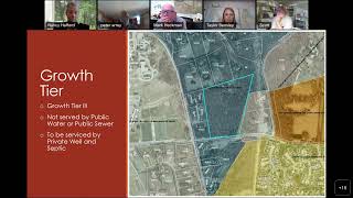
The
site
is
gross
tier
3,
which
triggers
the
planning
board's
review.
The
property
is
not
served
by
public
water
or
public
sewer.
The
development,
if
approved,
will
be
serviced
by
private,
well
and
septic.
The
map
on
the
screen
right
now
shows
the
growth
tier
designation
for
the
site
and
the
surrounding
properties.
E
E
The
applicants
are
proposing
six
single-family
detached
dwellings,
though
lots
are
proposed
to
be
approximately
1.9
to
approximately
6.4
acres
in
size.
The
dwellings
are
proposed
to
be
accessed
via
a
private
road,
there's
no
builder
tie-in
for
the
project.
However,
each
dwelling
must
meet
certain
performance
standards
as
far
as
architecture.
E
The
developer
has
already
completed
the
concept
plan
conference,
the
community
input
meeting
and
the
development
plan
conference.
Those
meetings
were
held
on
February
15,
2022,
April,
12,
2022
and
March
1st
2023
respectively.
Now
the
developer
is
seeking
review
by
the
planning
board
due
to
the
property
being
growth
tier
3..
The
development
will
have
a
hearing
before
the
administrative
law
judge
on
May
18
2023.
The
planning
boards
recommendation
on
the
plan
will
be
sent
to
the
alj
prior
to
that
hearing.
E
Following
the
hearing,
the
alj
will
issue
an
opinion
in
order
which
will
approve
or
deny
the
project
the
department
of
planning
commented
on
the
project
during
the
concept
plan
and
development
plan
stages.
We
will
also
offer
written
comments
ahead
of
the
alj
hearing
in
May,
and
we
will
testify
at
that
hearing
when
reviewing
a
major
development
plan.
E
The
department
of
planning
comments
on
the
appropriateness
of
a
project
in
terms
of
the
master
plan
2020
and
any
adopted
Community
plans,
any
waivers
or
variance
requests,
School
impact
architecture,
site
layout
and
design
amenities,
open
space,
signage
lighting,
Etc.
The
department
of
planning
is
in
support
of
the
development.
However,
we
did
have
a
few
outstanding
comments
at
the
time
of
our
last
review,
which
was
during
the
development
plan
conference
to
give
a
brief
overview.
F
Am
ready
good
afternoon
Madam
chair
members
of
the
planning
board
good
to
see
everybody
here
and
look
forward
to
seeing
everybody
in
person
in
a
few
weeks
when
we
have
the
public
hearing.
Thank
you
Taylor
for
that.
For
that
explanation,
I
wanted
to
to
give
a
little
bit
more
of
a
of
an
explanation
of
the
project
and
then
certainly
we're
here
to
answer
any
questions.
So
for
those
of
you
who
don't
know
me
again,
I'm
Chris
Mudd
I'm
an
attorney
at
Venable
Melania,
since
zoning
attorney
represents
the
applicant
in
this
matter.
F
Who
is
the
owner
of
the
subject
property
and
both
there
are
actually
two
individuals
and
they're
families
that
own
the
property
in
the
form
of
an
LLC
but
Mr
clay,
Goodyear
and
Mr.
Dan
callaher,
who
are
both
attending
in
the
attendees
section
this
evening,
are
the
owners
of
the
property
and
they
intend
to
be
two
of
the
six
residents
of
the
property
as
well.
So
they're
not
only
doing
this,
they
purchased
the
property
as
a
bit
of
an
investment
but
they're
also
purchasing
it
for
their
own
respective
homes.
F
Also
with
us
today
are
some
folks
from
from
Morrison,
Richie,
Associates
or
otherwise
known
as
MRA,
that
is
Mr
Mike,
Coughlin,
Jared,
Barnhart
and
Catherine
Barnes,
who
are
all
part
of
the
design
team
that
worked
on
the
development
plan
that
was
presented
by
Taylor,
at
least
a
portion
of
which
and
I.
It's
also
part
of
the
package
that
we
submitted
in
advance
of
this
hearing,
as
Taylor
noted
and
I'm
going
to
actually
share
my
screen
and
before
I,
get
into
sort
of
the
substance
of
the
matter
before
the
board.
F
So
the
subject
property
this
this
this
map
is
from
Baltimore
counties,
my
neighborhood
website
and
the
area
that
I'm
now.
Can
everybody
see
the
board
right?
Okay,
great
the
area
that
I'm
using
my
mouse
to
Mouse
over
here.
That's
the
subject
property
here
so
again
the
roads
aren't
called
out
here,
but
this
is
Falls
road
that
runs
north
south
in
this
direction.
This
is
Seminary
Avenue
that
runs
through
the
east,
from
Falls
Road
and
across
the
site
from
Seminary
Avenue.
In
this
direction
is
the
main
entrance
to
St
Paul's
School.
F
This
is
St
Paul's
School
that
I'm
now
mousing
over
here
and
I'll
talk
a
little
bit
more
about
what
you're
seeing
in
the
form
of
land
uses.
But
one
other
factor
I
want
to
mention
is
that
the
ertle,
the
urban
rural
demarcation
line,
runs
approximately
in
this
area,
where
I'm
mousing
over
here.
So
it's
just
south
of
the
site
and
then
once
the
ertle
gets
to
Seminary
Avenue.
It
just
runs
sorry
over
to
May's.
F
These
are
all
larger
Lots.
This
is
all
rc5
zoning
that
is
due
north
of
the
site
and
even
south
of
the
site.
West
of
the
site
is
rc2,
which
is
where
Saint
Paul's
is,
and
there
are
large
lot
subdivision
that
occurred
years
ago
under
a
prior
zoning
classification
of
rc5,
south
of
the
of
the
Saint
Paul
site.
F
But
this
developer
is
only
proposing
six
because
we
are
in
tier
three
mapped
in
tier
three
under
the
Baltimore
County
tier
Maps.
We
are
required
to
come
before
the
planning
board
for
this.
This
request
today,
which
is
approval
of
a
major
subdivision,
which
is
a
subdivision
that
exceeds
three
lots.
So
a
minor
subdivision
is
three
or
fewer
lots.
A
major
subdivision
is
anything
above
three
lots,
so
we
have
a
major
subdivision,
that's
proposed
within
tier
three,
which
brings
us
before
the
planning
board.
F
Today
your
scope
of
review
as
planning
board
members,
is
to
determine
whether
or
not
this
is
appropriate.
Evaluating
two
items:
the
cost
of
providing
local
government
services
to
the
residential
major
subdivision
and
also
the
potential
environmental
issues
associated
with
the
subject
property
I'm
going
to
switch.
Now.
Can
everybody
see
the
separate
package
that
I
have
here?
Okay,
great
yeah,
so
this
thank
you.
F
F
F
And
otherwise,
the
property
is
surrounded
by
a
mature
Road
Network
that
exists
in
this
area.
We're
proposing
six
new
single-family
homes
that
will
really
not
generate
any
significant
amount
of
traffic.
It
has
a
total
of
76
average
daily
trips
and
in
the
peak
hour,
for
anybody
who
is
familiar
with
how
traffic
studies
work.
F
F
The
site
is
is
sorry,
it
is
about
we're
about
2.3
miles
from
the
brookenville
fire
department,
which
is
the
local
or
the
closest
local
fire
department
that
services
this
site.
The
site
is
zoned
for
riderwood,
elementary
Ridgely
Middle
and
Delaney
High
School.
None
of
those
schools
are
are
projected
to
be
overcrowded
with
our
school
impact
analysis.
They
are
all
under
the
100
percent
capacity.
Numbers
I'll
give
a
little
bit
more
detail
about
that
as
we
move
forward.
F
F
As
a
consequence
of
developing
this
site,
given
the
existing
density
of
housing
in
this
area,
the
six
new
homes
will
not
have
any
appreciable
impact
on
the
provision
of
County
Services.
That
already
are
in
this
area
on
a
regular
basis.
There's
no
public
water
or
sewer
available,
so
there
will
be
no
cost
to
the
taxpayers
or
the
county
relative
to
Public,
Water
and
Sewer.
All
schools,
as
I
mentioned,
have
plenty
of
capacity
for
the
six
new
homes
ryderwood
Elementary
is
at
91
percent.
F
Ridgely
Middle
is
at
98
in
Delaney,
Valley
is
at
94
all
under
capacity.
The
property
is
located
as
I
mentioned
within
2.3
miles
of
brooklynville
Fire
Company.
It's
a
long-standing
and
well-established
fire
company.
That's
provided
excellent
service
to
constituents
in
this
area
for
many
years
at
the
six
new
homes,
with
appropriately
sized
roads
and
driveways
and
internal
code
required
sprinkler
systems
will
not
cause
any
issues
for
the
new
Fire
Company
to
serve.
Trash
pickup
will
occur
along
this
centralized
internal
circle
area
within
the
development.
F
These
these
notes,
Here,
which
I'll
zoom
in
a
little
bit,
indicate
where
trash,
pickup
and
mailbox
mailbox
mail
delivery
will
occur.
Interior
to
the
site
and
this
entire
road
on
the
internal
portion
of
the
site
is
a
private
drive
it's
under
this
labeling
here,
but
it's
labeled
as
a
private
Drive,
which
means
that
this
is
no.
There
are
no
new
public
roads
proposed
by
this
development,
so
there's
no
new
public
road
maintenance
and
no
new,
including
Paving
maintenance,
as
well
as
snow
removal,
and
things
like
that.
F
F
F
This
precise
configuration,
but
it
is
meant
to
show
you
that
the
developer
is
attempting
and
intends
to
maintain
a
buffer
between
the
neighbors
and
themselves,
and
so,
in
addition
to
the
9.2
Acres
that
will
be
permanently
preserved,
it's
anticipated
that
even
more
will
be
preserved,
albeit
not
in
a
Perpetual
easement,
also
by
keeping
the
roads
private.
As
I
mentioned,
much
of
the
effort
was
take
or
much
effort
was
taken
to
minimize
impervious
surfaces
within
the
development.
F
If
we
were
to
propose
the
public
road,
the
public
standards
that
would
have
meant
a
significant
amount,
more
of
disturbance
and
impervious
area
within
the
site.
Private
Road
enables
us
to
taper
that
down
quite
a
bit,
all
Lots
share
a
com.
This
common
entrance,
none
of
the
home
sites,
will
impact
the
proposed
environmental
easements,
which
Again
cover
about
42
percent
of
the
properties
total
acreage.
The
rc5
maximum
building
coverage
requirement
in
the
rc5
zone
is
15
of
any
lot
for
building
coverage.
All
of
our
Lots
far
exceed
that
15
maximum
permissibility.
F
Now
the
developer
in
preserving
these
9.2
Acres
worked
very
hard
with
Environmental
Protection
to
ensure
that
the
areas
that
were
preserved
were
the
highest
quality.
Forest
stands
on
site
and
environmental
is
also
approved
well
on
septic
Reserve
Area
locations
within
this
site.
As
part
of
our
as
our
efforts
in
the
development
plan
process,
storm
water
management
is
going
to
be
provided
on
this
site.
F
There's
no
storm
water
management
that
exists
to
date
and
there
will
be
storm
water
management
when
we
move
forward
the
county
and
state
storm
water
management
regulations,
mandate,
the
use
of
environmental
site
design
ESD
to
the
maximum
extent
practicable
on
site.
There
will
be
a
combination
of
small
storm
water
practices
that
serve
each
of
these
Lots,
as
well
as
a
larger
stormwater,
a
submerged
gravel,
Wetlands
storm
water
facility,
that
is
at
the
base
of
this
site.
E
F
The
storm
water
controls
that
are
going
to
be
in
place
so
in
summary,
we're
using
the
environmental
site,
design
practices
in
all
area
of
the
site
and
we're
going
to
be
providing
storm
water
management
that
will
satisfy
and
meet
all
County
regulations
and
requirements
and
we'll
cycle
quickly
through
the
other
exhibits
just
so
we
know
what
we
provided
and
why
the
next
couple
of
pages
here
on
this
slide
are
the
actual
development
plan
as
submitted
and
I
won't
belabor
these.
But
they
show
a
lot
of
information
and
notes
on
sheet1
sheet.
F
F
She
more
again
shows
more
detail
in
the
proposed
conditions
and
Sheet.
Five
is
just
a
breakdown
of
the
lot
layout
to
make
that
a
little
bit
clearer
and
less
busy
compared
to
the
other
sheets.
The
final
sheet
in
our
package
is
a
summary
and
I
won't
go
through
all
this
and
belaborate,
but
a
summary
of
everything
that
I
just
explained
to
you
today.
F
A
C
F
C
F
No
environmental
waivers
are
required
for
the
proximity
of
the
septic
areas
to
the
Stream
So.
The
septic
design
is
actually
a
very
tedious
exercise
and
Mr
Coughlin
could
probably
explain
a
little
bit
greater
detail
than
I
can.
But
you
have
to
be
very
cautious
about
having
septic
Reserve
areas
Upland
of
wells,
for
example,
you
have
to
be
within
a
certain
distance
of
Wells.
You
have
to
be
within
a
certain
distance
of
stormwater
management
facilities
and
you
have
to
be
within
a
certain
distance
of
a
distance
of
environmental
facilities.
D
F
D
B
I
think
you
mostly
got
it
Chris.
The
only
quick
thing
I'll
add
on
the
septic
bit
is
we
have
to
do
perk
tests
as
well
of
the
existing
soils
that
are
out
there,
and
so
the
soils
have
to
perk
at
certain
rates
in
order
for
septic
systems
to
be
feasible
and
those
tests
have
been
performed
in
the
desired
minimum.
A
F
It
love
it
so,
yes,
long
before
the
applications
were
even
filed,
the
the
property
owners
went
and
met
with
the
neighbors
and
they've
continued
the
the
dialogue
with
the
neighbors,
so
we've
been
had
and
I'll.
Actually,
my
client
is
listening
and
I.
Don't
think
they're
here
to
to
weigh
in
but
I'm
going
to
ask
them
to
text
me
how
many
meetings
they've
had
so
we
can
get
that
on
the
record.
F
Yeah
understood
so
so
one
thing:
I'm
gonna
I,
want
to
take
a
little
bit
of
a
of
a
of
a
trip
down
memory
lane
or
visit
a
little
bit
of
History.
So
I
was
involved
previously
with
a
proposal
on
this
site
for
a
large
church
that
was
proposed
geez,
it's
probably
going
on
eight
to
ten
years
from
now,
10
8
to
10
years
or
so
now,
and
that
development
was
extremely.
F
You
know
opposed
with,
with
a
lot
of
venom
and
and
a
lot
of
the
people
there
were
concerned
about
the
amount
of
clearing
they
were
concerned
about
you
know
any
number
of
things
and
Mainland
traffic
was
a
big
concern
that
people
had
at
that
time
too,
particularly
given
the
size
of
the
church
and
the
number
of
parishioners
and
so
forth.
At
the
time
we
were
having
Community
input,
meetings
and
and
all
of
the
community
involvement.
In
that
case,
people
basically
said
you
know
this.
This
should
be
residential.
F
This
is
what
this
site
is
begging
for
it's
more
appropriate
to
be
residential
and
that's
really
what
it
should
be,
and
so
here
we
are
proposing
a
six
lot
subdivision.
Four
lots
and
I:
don't
know
whether
you
heard
this
part,
but
it's
it's.
It
has
the
density
in
its
Zone
to
allow
10..
It
only
proposes
six,
so
the
scope
of
what
the
neighbors
are
are
facing.
F
But
that's
been
really
the
only
issue
that
I
think
that
we've
encountered
and
my
clients
have
listened
and
they've
cooperated.
They've
met
had
four
to
five
in-person
meetings,
multiple
emails
and,
and
actually
the
one
of
them
said
four
to
five,
the
other
things
six
to
seven,
so
maybe
about
a
half
dozen
meetings
we'd
have
with
the
neighbors,
and
we
continue
to
reach
out
to
the
neighbors
we've
we've
shared
with
them.
F
For
example,
you
know:
hey
we're
going
to
file
the
we're
filing
development
plan
this
week,
here's
your
copy,
as
opposed
to
the
normal
copy
they
get
in
the
mail
through
the
process
as
required
by
law.
So
it's
been
a
significant
amount
of
Outreach
I
can't
promise
you
that
we've
resolved
every
concern
and
I'm
sure
we
haven't,
but
I
think
that,
generally
speaking,
the
feeling
in
the
community
is
relief
compared
to
what
it
was
before.
H
F
So
I
can
I
can
answer
that
the
hurdle
was
not
moved,
but
they
do
have
public
water,
which
occurred
by
way
of,
what's
called
a
special
exception
to
the
to
the
master,
Water
and
Sewer
plan,
and
the
reason
that
that
happened
was
because
there
was
a
fire
that
was
there
a
number
of
years
ago,
and
it
was
determined
that
the
Well
Service
was
just
insufficient
from
that
perspective.
So
they
got
permission
for
public
water.
They
do
not
have
public
sewer
they're
on
septic
there
there
are.
F
F
H
H
I
had
was
wasn't
the
county
sued
because
of
its
discriminatory
practices
by
not
allowing
the
church
to
move
in
there.
Wasn't
there
a
a
lawsuit
that
we
end
up
settling
as
an
accounting
because
of
that
yeah
not
on
the
site,
not
on
that
set.
Okay,
no,
and
then
you
know
the
the
last
comment
I
would
make
is
that
you
know
this
is
on
a
major
thoroughfare
that
leads
within
a
mile
of
from
a
major
exit
on
to
a
major
High,
several
two
major
highways,
one
being
83
and
2
being
695.
So
this
is.
H
A
D
D
D
A
Thank
you.
As
a
reminder,
the
public
hearing
will
be
in
person
on
April
20th.
The
board
is
tentatively
scheduled
to
discuss
and
vote
on
the
matter
immediately
following
the
public
hearing,
Miss
Bensley
will
now
fill
us
in
on
legislation
recently
passed
by
the
County
Council
following
our
last
meeting
Miss
Bensley
thank.
E
You,
madam
chair
Bill,
10-23
zoning
regulations,
uses
permitted
in
the
rc2
zone
catering
halls,
converted
from
dwellings
for
the
purpose
of
Permitting,
buy
right,
the
conversion
of
dwellings
to
catering
halls
in
the
rc2
resource
conservation,
agriculture,
Zone
under
certain
circumstances,
setting
additional
restrictions
and
limitations
under
certain
circumstances
and
generally
relating
to
uses
permitted
in
the
rc2
zone.
And
that
concludes
the
report.