►
Description
Feb. 15, 2022 Planning Commission Work Session – Upper Magnolia West Presentation.
Note: This is the first half of the work session until the 3 p.m. break by the commission. This only includes the presentation on Upper Magnolia West.
A
Thank
you,
madam
clerk.
It
brings
us
to
item
4b
on
our
agenda
today
and
that
is
going
to
be
a
report
and
overview
of
the
upper
magnolia,
green
east
and
west
development
zoning
cases.
I
believe
we're
starting
out
with
a
brief
introduction
today
and
then
we'll
go
straight
into
staff.
Okay,
thank
you,
mr
donahoe.
B
B
This
it's
made
up
of
two
rezoning
cases.
It's
split
by
the
po
white
parkway.
We
refer
to
the
projects
as
upper
magnolia,
green
west
and
upper
magnolia
green
east.
What
we're
going
to
do
today
is
we're
going
to
continue
the
discussion
and
review
of
the
pro
of
the
proffers.
We
have
revised
proffers
as
well
as
a
revised
conceptual
plan,
so
we're
happy
to
bring
that
before
you
and
discuss
that
in
detail
and
how
we
kind
of
arrived
at
the
elements
that
are
contained
within
the
conceptual
plan
and
the
properties
themselves.
B
We
have
assembled
a
team
today
to
go
through
the
various
sections
of
the
proffers
with
you.
We
have
this.
The
folks
that
are
part
of
this
team
have
provided
they've,
provided
a
review
in
the
case
as
well
as
drafted,
proffers
and
provided
comments
to
the
applicant
we
have.
The
applicant
in
this
case
is
the
eda
we
do
have
the
applicant's
representative
here
as
well.
That
would
be
available
to
answer
questions.
That's
andy,
conlon
he's
in
the
audience
we
have.
B
The
structure
of
today's
presentation
will
be
to
go
through
the
upper
magnolia
west
project.
First,
we're
going
to
start
off
with
the
transportation
portion
of
the
review
provided
by
brent
epps.
Then
we're
going
to
have
a
utility
section,
that'll
be
mike
mannery,
followed
by
engine
environmental
engineering,
scott
dunn
and
then
planning
is
going
to
follow
up
at
the
end
of
that
to
go
through
the
the
profits
that
we
have
from
the
planning
perspective.
B
B
As
a
of
a
planning
commission
work
session,
we've
had
five
community
meetings
so
far,
four
were
solely
dedicated
for
the
discussion
of
this
case
and
there's
another
meeting
planned
on
on
march
10th,
that's
going
to
be
hosted
by
chair,
owens
and
and
commissioner
sloane,
so
we
have
that
upcoming.
This,
of
course,
is
a
very
large
project
and
naturally
it's
garnered
a
lot
of
public
attention
and
a
lot
of
feedback.
B
But
buffers
have
always
been
a
key
discussion
point
in
the
case,
especially
on
the
west
side
of
the
upper
magnolia
west
project,
especially
along
the
mosley
road
area,
uses
in
particular,
I
think
very
early
on.
There
was
perhaps
some
misunderstanding
out
there.
Perhaps
maybe
some
misinformation
about
what
exactly
the
uses
were,
that
we
were
proposing
the
i2
zoning
district
does
allow
for
a
lot
of
uses.
However,
in
this
particular
case
for
being
very
prescriptive
and
saying,
only
seven
uses
now
are
going
to
be
permitted
on
the
property.
B
The
construction
of
westerlu
parkway,
the
actually
the
ultimate
build
out,
whether
it's
a
two
or
four
lane
piece
of
infrastructure.
That
was
a
point
of
contention
that
that
we
heard
from
the
public
that'll
be
addressed
in
the
presentation.
Also,
the
the
school
site,
the
public
use
site
we
had
very
early
on.
We
had
a
high
school
middle
school
elementary
school
as
well
as
a
library
on
a
roughly
200
acre
piece
of
property.
B
There's
been
changes
to
that.
We're
going
to
update
you
on
on
that.
There's
also
you
know,
associated
with
that
particular
issue
is
traffic
to
that
site
and
the
construction
of
the
surrounding
infrastructure,
the
north-south
road,
in
particular
the
timing
thereof.
That's
also
something
we
heard
and
we're
going
to
be
touching
on
that,
because
things
have
changed
in
the
proposal
and
then,
lastly,
there
was
a
desire
from
that
was
expressed
by
particularly
the
westerly
and
summer
lake
communities
for
continued
involvement
in
the
development
of
the
project.
B
Next,
what
I
want
to
review
with
you
is
this:
this
slide.
This
has
been
shared
with
the
board
actually
and
what
this
is
is
representative
of
the
issues
that
were
raised
at
the
previous
two
planning
commission
work
sessions
and
the
follow-up
discussions
that
I've
had
with
each
one
of
you,
and
so
we
put
that
on
this
list
here
and
we're
going
to
be
addressing
each
one
of
these
in
this
presentation,
and
so
we're
looking
forward
to
that
to
get
into
the
detail
of
that
very
soon,
but
wanted
to
show
everybody
before
we
get
started.
B
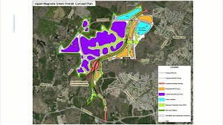
This
is
the
revised
conceptual
plan
that
we
have
for
the
entirety
of
the
project.
This
is
this
includes
both
the
east
and
the
west
side
of
the
of
the
project.
As
you
can
see,
if
you
remember
the
the
original
plan,
this
is
definitely
an
improvement.
We
have
identified
areas
of
development,
we've
better
delineated,
the
rpa
environmental
areas
on
the
site,
improved
buffers
as
well.
B
We've
included
the
trail
network
which
we
did
have
before,
but
I
think
it's
a
better
developed
trail
network
this
time
around
and
so
we've
we've
heard
what
the
concerns
were.
The
planning
commission,
as
well
as
the
community
and
we've
addressed
those
in
in
features
in
the
conceptual
plan
and
we'll
go
into
this
in
more
detail,
but
first
up
we
have
brent
from
transportation
and
so
I'll
get
out
of
the
way
and
let
him
address
some
of
the
transportation
issues
with
the
project.
C
C
D
D
C
Okay,
so
as
those
are
being
distributed
for
your
reference,
just
wanted
to
start
with
a
little
bit
of
background
on
where
we
are
with
the
traffic
impact
analysis.
We
we
discussed
this
in
some
detail.
The
last
time
we
met,
but
I
did
want
to
update
you
that
both
both
of
the
tias
one
for
the
east
and
one
for
the
west
case
were
submitted
to
vdot
for
their
review
on
january,
the
14th
subsequent
to
the
submission
to
vdot.
C
Again,
the
tia
addresses
existing
conditions.
It
grows
that
future
based
on
the
existing
conditions.
It
also
grows
future
traffic,
both
with
and
without
the
development,
and
then
we
add
on
to
that
future
traffic
growth,
the
projected
development,
the
traffic
from
the
from
the
development
based
on
that
traffic
impact.
We
recommend
mitigation
measures
and
those
are
both
based
on
operational
analyses
and
safety.
C
To
give
you
an
idea
about
the
project
traffic
projections,
we
include
for
the
middle
school
only
we
did
a
specific
study
year
for
2024
that
allows
us
to
require
specific
improvements
with
the
middle
school
when
it
comes
online
and
then
also
allows
for
additional
improvements
in
the
future
at
2041,
which
is
the
design
year
that
we
are
currently
working
towards
the
west
case.
We
everything
that
you
see
will
be
based
on
2041,
which
is
a
corresponding
design
year
for
the
west
case
as
well.
C
C
One
one
more
item.
I
wanted
to
point
out
on
this
slide.
We've
broken
out
each
of
the
uses
on
the
on
the
eastern
case,
as
well
as
on
the
western
case,
and
you
see
you
have
a
good
feel
for
the
size
of
the
schools.
On
the
eastern
case,
the
total
number
of
single-family
units
in
the
eastern
case
on
the
western
case,
the
the
total
square
footage
that
we're
projecting
for
the
industrial
is
approximately
13.2
million
square
feet.
C
C
So
getting
into
the
proper
conditions
for
the
west
case.
Generally
speaking,
the
transportation
profits
for
the
west
case
are
broken
down
into
four
areas.
We
have
right-of-way
dedication,
access,
condition,
road
improvements
and
a
phasing
condition
here
is
the
chart
that
outlines
the
right-of-way
dedications
for
the
roadways
that
we're
anticipating
improvements
along.
C
The
access
plan
that
they'll
provide
will
correspond
to
each
road
referenced
in
the
plan
and
in
such
a
time
that
the
access
is
proposed
to
or
from
the
property
to
that
roadway.
So
we
will
know
exactly
where
each
access
point
will
be
to
and
from
the
property
and
one
other
item
that
that
we've
added
to
this
condition,
most
recently
in
response
to
some
community
input,
we
have
included
in
the
proffer
that
there'll
be
no
direct
access
to
and
from
the
property
to
mosley
road.
C
Getting
into
the
road
improvements
portion
of
the
proffer,
one
thing
we
want
to
note
is
that,
in
conjunction
with
initial
development
and
each
additional
phase
of
development,
the
owner
will
submit
for
approval
by
us
a
trafficked
impact
analysis
and
otherwise
known
as
a
traffic
study
and
a
plan
for
the
overall
development
of
the
property
showing
road
improvements
neces
necessitated
by
the
uses
and
the
density
again.
That
traffic
study
would
be
provided
upon
initial
development
and
then
any
subsequent
phases
of
development.
C
So
we've
got
a
rather
lengthy
list
of
improvements
associated
with
the
west
case.
This
is
the
second
map
in
your
packet.
It's
a
little.
It's
a
little
easier
to
understand
the
level
of
the
improvements
when
looking
at
a
map
as
compared
to
just
a
list
of
improvements,
but
I'll
go
through
briefly
what
the
what
the
improvements
are,
and
if
you
have
any
questions
you
know,
please
don't
hesitate
to
ask
so
the
num.
C
C
The
proposed
improvements
at
that
intersection,
the
traffic
analysis
that
we've
done
wouldn't,
would
require
a
green
tea
signal
and
some
additional
turn
lanes.
But
again,
all
these
would
be
confirmed
and
in
accordance
with
the
the
traffic
analysis
that
the
developer
would
do
also
improvements
to
route
360
from
beaver
bridge
road
to
cosby
road.
C
C
Yes,
sir
genito
from
mount
hermon
to
otterdale,
improving
that
as
a
tulane,
yes,
otterdale
road
from
duvall
to
woolridge
road,
yes,
sir,
and
so
all
of
those
roadway
segment
improvements
would
also
have
their
corresponding
intersections
improved
as
well.
So
we
don't
have
specific
intersection
improvements
for
enter.
You
know
intersection.
Seven,
we
haven't,
we
have
an
idea
about
what
would
go
there,
but
those
are
not
listed
specifically
in
the
properties
because
they
would
be
included
as
part
of
the
roadway
improvements
for
that
area.
C
Is
that
clear,
okay
and
then,
as
a
part
of
the
roadway
improvements
proffer,
the
applicant
has
included
a
a
phasing
plan
will
be
provided
prior
to
any
site
plan
approval
for
the
improvements.
So,
along
with
the
traffic
study
and
then
prior
to
any
subsequent
site
plan
approval,
they
would
have
a
phasing
plan
approved
for
the
improvements
that
would
be
required
for
that
phase
of
their
development.
A
C
You're
referencing
intersection
number
19.
Yes,
sir,
mr
owens,
we
we
don't
have
any
right-of-way
in
that
area
at
this
point
at
this
point.
That
section
of
the
therefore
plan
are
our
lines
on
a
map
and
and
they
can
shift
one
way
or
the
other,
as
we
you
know
need
to
in
order
to
accommodate
those
improvements.
So
so,
while
we
have
them
shown
on
a
map,
we
haven't
located
them
from
an
engineering
standpoint
at
at
this
point,
so
they're
still
available
to
be
shifted
as
necessary.
C
A
A
C
A
C
We
do
expect
there
to
be
fewer
vehicles
using
westerly
parkway
between
otterdale
road
and
the
north-south
collector,
as
it
pertains
to
the
high
school
so
as
the
high
school
would
have
access
to
mount
hermon
access
to
you
know,
westerly
parkway,
west
of
the
pow
height
and
having
the
north
south
collector
constructed
between
westerly
and
duvall.
We
do
expect
that
to
relieve
some
traffic
from
westerly
between
otterdale
and
the
north-south
collector.
A
And
then
the
last
question
I
have-
and
it's
just
I'm
making
sure
I
understand
this.
One
of
the
things
you
all
said
was
there
would
be
no
access
to
the
site
from
mosley
road
and
that
that
small
road
on
the
northwest
corner
that
goes
to
mosley
road
from
the
site.
I'm
trying
to
understand
how
that
road
is
there
when
you're
saying
there's
going
to
be
no
access
to
mosley,
I'm
just.
C
E
C
In
the
previous
proposal,
with
all
three
schools
being
on
the
same
site,
we
knew
all
three
schools
were
going
to
be
accessed
in
the
same
way
from
the
network.
What
we've
done?
What
the
proposal
is
has
done
now
is
it's
taken
the
high
school
removed
it
from
that
original
school
campus
and
relocated
it
to
another
area
which
provides
different
points
of
access
and
opportunities
for
the
network
to
absorb
those
trips
in
a
different
way.
So,
overall,
it's
a
benefit
to
the
east
case,
because
it's
reduced
the
number
of
trips
in
the
west
case.
E
E
And
my
question
is
not
so
much
to
to
stump
you
or
anything.
It's
just
really
to
bring
light
to
some
things
have
been
moved
around.
Some
conversations
have
been
had
and
we
realized
that
originally
some
things
might
not
have
been
positioned
where
they
need
to
be
positioned
on
the
track
of
land
and
now
we've
we've
had
those
conversations
gone
back
and
done
some
study
and
we
really
understand
where
they
need
to
go
now,
based
on
those
conversations.
C
F
C
So
let
me
before
I
go
into
the
details
of
what's
in
the
proper
I'll
I'll
state,
in
general
terms,
the
the
difficulty
with
putting
together
a
phasing
plan,
for
I
mean
it's
the
it's
the
pow
height
that
we're
talking
about
so
the
difficulty
with
saying
before
you
have
x
number
of
square
feet
of
industrial
developed
on
the
on
the
site.
You
will
build
a
portion
of
the
pow
height
from
a
to
b
and
then
another
percentage
from
b
to
c
the
difficulty
with
that
is
I
can.
C
If
we
get,
let's
say
that
the
site
develops
with
two
million
square
foot
users,
so
you've
got
two
million
square
feet
out
there
and
you've
got
nothing
for
the
pow
height
built,
and
then
you
get
another
user.
That's
two
million
square
feet,
so
you
got
four
million
square
feet.
You
still
have
nothing
built,
it'll,
be
a
race
to
4.9
million
square
feet
and
everything
will
stop
if.
F
What
what?
Where
does
something
in
there
trigger
that
we've
got
to
do
something
to
address
it?
I
mean
in
the
case,
in
the
91
case,
the
traffic
analysis
basically
said:
65
900,
average
daily
trips
and
staff
said
no
to
the
case,
because
the
applicant
wouldn't
proffer
at
least
two
lanes
and
address
the
issues
on
the
thoroughfare
plan.
F
A
C
F
C
C
The
eda
can
choose
to
include
it
or
not
include
it,
but
it
would
be
a
guess
on
my
part,
based
on,
however
many
square
feet,
we
want
to
include
or
however
many
trips
per
day.
We
want
to
include
as
to
what
user
it
is
and
where
it
would
be
located
on
the
site
and
at
the
end
of
the
day,
I
still
think
it
would
be
a
race
to
that
minimum
number
of
trips
before
you
hit
that
trigger
to
build
the
pow
height
and
then
development
would
stop.
A
C
C
A
plan
for
the
powwow
parkway
extension
to
include
a
timeline
and
a
financing
plan
will
be
submitted
to
and
approved
by,
the
board
of
supervisors.
That's
with
initial
development
prior
to
any
plans
being
approved.
That
would
that
plan
for
the
power
parkway
extension,
including
a
timeline
and
a
financing
plan,
would
have
to
be
submitted
to
and
approved
by,
the
board,
chair
and
then
prior
to
any
prior
to
the
issuance
of
any
co
for
any
development
on
the
property.
They
have
to
construct
two
lanes
of
powite
from
360
to
the
magnolia
green
parkway
interchange.
G
C
G
C
C
C
H
F
How
would
the
boy
how
and
I
don't
want
to
I'm
getting
outside
my
swim
lane-
and
I
shouldn't
do
this,
but
how
can
we
put
a
reasonable
proffer
or
recommend
a
re
except
a
reasonable
proffer
from
the
applicant
that
includes
a
component
called
financing
when
that's
not
something?
That's
necessarily
within
the
board
of
supervisors,
control.
G
Mr
chairman,
and
just
to
understand
that,
wouldn't
because
at
that
point
in
time,
when
a
plan
is
being
presented,
a
developer
is
going
to
be
known
and
at
that
point
the
board
would
have
the
facts
to
base
the
decision
on
to
to
know.
If
a
financing
plan
was
going
to
be
viable
or
not,
depending
on
who
that
user
is.
C
Yes,
ma'am
and,
and
the
count
into
mr
sloane's
point
the
the
county
would
have
to
be
at
the
table.
The
state
would
have
to
be
at
the
table
there.
Wouldn't
there
need
to
be
a
number
of
of
key
stakeholders
and
and
players
at
the
table
to
develop
that
that
timeline
and
financing
plan
that
will
not
be
created
in
a
vacuum.
C
C
A
A
C
So
what
they,
in
our
conversations
with
vdot,
they
are
working
to
understand
the
mitigating
improvement.
The
improvements
that
we're
making
to
mitigate
the
development
do
not
address
all
of
the
issues
that
we're
having
on
the
intersections
within
the
study
area.
So
what
we're
trying
to
do
is
parse
out
the
impacts
based
on
the
development
versus
some
issues
that
already
exist
along
the
corridor
and
in
specific
intersections.
F
F
F
F
F
F
That?
Would
that
would
give
perhaps
give
a
give
perhaps
a
recommendation
on
given
a
certain
number
of
trips
per
day.
So
maybe
it's
something
like
for
every
million
square
foot.
That's
developed,
it
triggers
a
traffic
impact
analysis,
and
you
know
we
look
at
number
of
trips
generated
that
could
come
up
with
a.
F
C
We
can
certainly
look
at
something
like
that.
I
think
so
number
one
just
just
to
be
crystal
all
of
the
improvements
to
the
to
the
network
external
of
the
site
are
are
a
result
of
the
analysis
that
we've
that
we've
already
done
what
what
we're
requiring
of
the
developer
is
that
again,
just
as
you
mentioned,
regardless
of
how
many
or
the
size
of
each
phase
of
development
we're
going
to
require.
That
study
be
done.
C
Again,
I
think
we've
got
a
pretty
good
idea
of
what
that
is,
but
certainly
the
subsequent
traffic
studies
that
will
be
done
as
a
part
of
the
proper
conditions
will
speak
to
that.
You
know
more
more
specifically,
I
think
where
we're
really
at
is
trying
to
to
look
at
a
st
at
a
at
a
model
that
would
somehow
provide.
C
C
C
F
I
don't
think
it's
unreasonable
in
that
recommendation
in
the
staff
report
or
the
board
to
have
a
good
understanding
of
what
what
are
the?
What
are,
what
are
the
metrics
that
that
they're
going
to
need
to
look
at
and
consider
when
it
comes
to?
Does
that
road
get
built
to
a
public-private
partnership?
Does
it
get
built
with
stunt
funding
from
the
state?
If
it,
you
know
all
of
those
what-if
scenarios,
but
I
think
it's
a
reasonable
expectation
that
that
there's
a
knowledge
of
based
on
a
certain
metric.
F
The
only
thing
that
I
probably
need
additional
help
with
and
I'll,
let
you
go
okay.
You
know
when
I
look
at
when
I
look
at
the
road
improvements
under
profit
10,
I
see
language
that
says
as
part
of
plan
review
for
phase
one
owner
developers
shall
submit
the
transportation
department,
traffic
impact
analysis,
such
improvements,
and
then
it
says
at
each
phase
of
development.
F
I
Yeah,
excuse
me:
yes,
it
would
be,
as
the
request
for
a
site
plan
would
be
submitted.
We
would
have
the
information
with
that
submittal
to
get
start
to
establish
what
level
of
a
tia
would
be
necessary
for
them
to
put
together
for
that
project,
be
it
a
10,
acre
site
or
a
200
acre
site.
They
would
be
putting
together
the
appropriate
tia
based
on
what
they're
proposing
at
that
location.
I
So
it
could
be
a
larger
full-blown
global
type
of
present
tia
or
it
could
be
a
much
smaller
kind
of
project,
depending
on
the
the
size
and
scale
of
the
of
the
proposal
that's
being
made,
but
for
every
site
plan
that
would
be
coming
into
within
upper
magnolia
west.
They
would
be
having
to
meet
that
criteria.
F
And
again,
this
is
this
is
just
me.
I
don't
want
to
speak
for
any
other
commissioners
up
here,
but
if
andy,
if
maybe
your
team
could
work
with
brett
to
just
make
it
just
a
little
a
little
clearer
to
those
of
us
that
don't
spend
our
lives
in
planning
all
the
time
and
understanding
the
nuances
of
of
what
exactly
is
trick.
What
are
the
specific
events
that
will
trigger?
I
I
I
I
just
you
know.
I
know
this
is
hard
and
it's
a
lot
to
digest,
for
you
guys
as
much
as
you
can
provide
us
in
input
regarding
transportation
aspects
to
the
west
side.
If
there's
any
other
thoughts
you're
having
such
as
what
mr
sloane's
been,
you
know
explaining
and
trying
to
get
across
any
of
the
other
thoughts
you
guys
had
as
to
how
we
might
be
able
to
approach
this.
It
is
a
very
unusual
and
complicated
process
project
and
we're.
I
A
Oh,
you
weren't
thinking
that
oh
okay!
Well,
I'm
thinking
that
I'm
worried
about
that.
I'm
worried
about
it
changing
because
nothing
in
there
says
I
have
to
come
back
through
planning
again
and
go
through
public
hearings
and
people
hear
what
the
plan
is.
It
just
says
the
board's
going
to
make
a
plan
and
it
leaves
it
open-ended
for
the
board
to
come
through
and
make
that
plan
and
make
changes
to
it,
how
they
see
fit
in
the
future
without
any
kind
of
phasing
plan.
Yeah
the
phasing
plan,
without
anybody
really
having
to
do
it
publicly.
A
A
J
I
J
I
F
You
know
a
successful
employment
center
in
an
environment
where
the
state
and
the
federal
government
says
we,
we
don't
have
an
extra
billion
dollars
laying
around
we.
We
gave
all
that
money
out
in
2021
2022
right.
We
gave
the
however
many
trillions
out
for
federal
transportation
dollars,
and
you
know
that's
covering
us
for
the
next
15
years
or
something
like
that.
So
I
I
worry
about
going
back
to
what
the
chair
said.
F
I
understand
some
will
take
woolwich,
so
I'm
gonna
take
whatever,
but
but
even
if
it's
half
that
thirty
thousand
trips,
something
like
that
to
me,
there
has
to
be
some
sort
of
metrics
to
ensure
either
either
you're
going
to
pull
back
on
the
liver.
You
know
there's
going
to
be
something
that
says
we're
going
to
pull
back
on.
F
You
know
we're
going
to
pull
back
on.
You
know
developing
out
the
western
side
or
we're
going
to
figure
out
another
way
to
pay
for
the
road,
and
I
I'm
not
here
it's.
It
is
absolutely
not
within.
I
believe
my
swim
lane
to
tell
anybody
how
to
pay
for
it
right,
that's
neither
here
nor
there,
but,
by
the
same
token
I
I
can't
think
of
too
many
cases.
Large
cases
and
again,
I
think
cases
like
roseland
and
brainerd
station,
where
you
know
thoroughfare
plans
in
detail,
were
approved
phasing
and
I
mean
branter
station.
F
I
mean
how
much
more
meticulous.
Could
it
be
right?
X
number
houses
triggers
this
x
number
units
triggers
that
whole
nine
yards.
Nowhere
in
there
was
there
was
there
was
there
and
I
think
they
were
building
up.
You
know
they're
building
the
east
west
freeway,
you
know
big
expensive
roads,
but
nowhere
in
that
case
did
it
say
contingent
upon
hh
hunt's
ability
to
get
financing
that
wasn't
our
problem.
They
had
to
build
it
one
way
or
the
other.
F
I
I
It's
going
to
take
a
partnership
of
state
and
federal
and
county
to
and
the
developer,
to
make
that
road
connection
so
figuring
out
how
to
do.
That
is
tough.
What
the
idea
and
as
everyone
is
you've
been
talking
about
you
know,
kind
of
and
and
the
point
that
mr
epps
brought
up
as
to
once
we
get
close
to
that
benchmark.
It
would
kind
of
start
to
slow
down
development
because
nobody
wanted
to
cross
that
hurdle.
I
If
there
is
a
way
we
could
create,
some
sort
of
you
know
incremental
pay
in
as
depending
on
you
know,
if
you
were
creating
x
number
of
trips
with
it,
whatever
you
were
proposing
with
with
your
project
you
had
to
provide,
you
know
a
certain
contribution
based
on
those
trips.
Would
that
be?
I
don't
know,
would
that
be
for
a
project
like
this,
be
something
that
would
be
a
better
more
important.
A
Could
we
maybe
look
at
something?
Could
we
maybe
look
at
something
like
we?
We
have
people
proffer
so
much
per
house
for
so
much
per
square
foot
or
something
of
that
nature.
I
guess
the
worry
is
that
you
say
you
say
that
the
development
will
slow
down
when
we
get
to
a
certain
point
where
one
of
the
triggers
are
that's
kind
of
the
whole
point
of
the
phasing
in
order
to
keep
going.
A
You've
got
to
do
this
part
here
in
order
to
go
to
the
next
phase
and
if
it
slows
it
down
and
stops,
then
that's
kind
of
the
point,
if
they're
not
doing
the
rest
of
it.
That
needs
to
stop,
because
we
can't
keep
doing
what
we've
done
the
whole
street
and
what
we've
done
to
some
of
the
other
parts
of
the
county.
A
A
We've
we've
got
to
start
putting
plans
in
place
and
and
make
them
phase
in
and
make
them
stick
to
the
phases
and
not
give
people
outs
and
not
change
things
later,
and
I
think
we're
doing
a
good
job
of
that
now.
But
we've
gotta
we've
got
to
start
doing
that
and
sticking
to
that
or
else
we're
gonna
end
up
with
unpassable
roads.
E
A
D
E
You
know
I
see,
I
see
it
kind
of
both
ways
right
because,
with
the
developer,
they
they're
gonna,
they
have
income
coming
in
they
can.
They
can
make
that
happen
more
more
so
than
chesterfield
county,
because
chesterfield
county
would
be
in
charge
of
making
sure
they
had
enough
money
in
order
to
make
the
road
improvement.
So
I
guess
it
might
be
something
that
economic
development
might
have
some
ideas
on
or
some
other
department
agencies
might
be
able
to
help
us
with
making
the
framework
to
say
when
you
get
to
a
certain
point.
E
Hopefully
we'll
have
the
money
in
place
the
revenue
in
place
based
on
what
we,
what
we
expect
to
get
in
from
income
taxable
income?
Maybe
it's
maybe
it's
trace
of
the
taxes.
Maybe
it's
traced
to
something
else
for
the
businesses
that
we'll
put
on
those
parcels.
So
I
don't.
I
think
that
a
developer
has
that
same
kind
of
issue
in
a
way,
because
they're
trying
to
figure
out
how
many
houses
do
I
have
to
build
in
order
to
make
those
road
improvements
and
we're
kind
of
looking
at
it.
How
what
do
we
have
to
attract?
E
E
You
know
kind
of
both
ways
for
as
soon
as
when,
when
you
have
a
a
public
project
like
this
versus
a
private
project,
I
think
you
kind
of
run
into
some
some
barriers
there,
where
you
might
need
to
reallocate
some
funds
to
another
project
or
something
else
gets
it's
a
different
priority.
So
you
can't
shift
that
priority
as
quick.
E
I
I
E
E
Right,
so
we
know
that
we
can
allocate.
We
need
to
allocate
this
amount
of
money
to
the
road
improvement
and
figure
out
how
we
do
that
in
ear
market
throughout
the
budgeting
cycle,
to
make
sure
we
have
enough
money
at
that
at
that
particular
time.
I
don't
know.
If
that's
I
don't
know,
if
that's
the
right
answer,
but
it's
just
we're
kind
of
openly
talking
about
is
our
work
session,
so
we're
just
trying
to
figure
out
what
what
are
the
triggers.
E
K
K
From
our
previous
conversations,
it
was
apparent
that
there
was
some
concern
on
the
industrial
discharges
that
could
be
produced
from
this
development
and
any
impacts
it
would
have
on
the
public
utility
system.
So
we've
asked
the
applicant
and
they've
graciously
accommodated
our
request
and
they
proffered
here,
as
you
see
on
your
screen,
number
12.
F
talking
about
wastewater
pre-treatment,
the
proper
reads:
any
user,
discharging
non-domestic
wastewater
to
the
public
waste
water
system
shall
be
required
to
comply
with
the
industrial
wastewater
discharge,
permitting
requirements
of
the
utilities
department.
K
K
If
that
happened,
we
could
have
treatment,
upsets
and
or
we
could
have
contaminants
that
would
impact
our
ability
to
dispose
of
our
bio
solids.
So
that's
one
of
the
goals.
The
next
major
goal
is
they're.
There
to
prevent
the
substances
from
getting
into
the
system
to
start
with
anything
that
could
pass
through
the
plant
that
we
couldn't
adequately
treat
or
completely
treat,
may
have
an
impact
on
the
aquatic
systems
of
where
we
are
discharging
and
those
receiving
waters.
K
So,
a
little
bit
more
about
pre-treatment,
chair
owens
asked
the
last
conversation
we
had
about
this
subject
matter.
What
were
some
of
the
things
that
we
regulated?
We
do
metals,
we
do
ph
fats,
oils
and
grease.
We
commonly
call
it
fog,
those
things
clog
up.
Our
system
total
suspended
solids,
biological
oxygen
demand
and
then
the
old
chest-based
stuff,
the
nitrogen
and
phosphorus
and
removal
that
we
do
we
have.
Actually.
I
said
we
had
a
robust
pre-treatment
system.
K
K
K
What
do
these
groups
do
in
the
pictures?
I've?
These
are
actual
pictures
from
our
team.
They
go
out
and
they
do
wastewater
sampling.
Two
of
the
pictures
show
one
of
our
team
members
installing
the
sampler
in
a
manhole.
It
shows
the
manhole
sampler
installed
grabbing
the
samples
out
of
the
actual
sewer
system
below
grade
and
then
some
of
our
site
inspections.
One
of
those
is
the
upper
left,
is
sabra
and
the
lower
right
is
at
the
defense
supply
center.
K
At
the
last
community
meeting,
there
was
some
conversation
about
how
will
we
assure
that
our
waste
water
and
water
system
is
of
quality
construction
and
it
won't
leak
out
into
the
ground
water?
So
I
want
to
spend
a
little
bit
of
time
assuring
you
that
our
construction
inspectors
are
on
the
job
we
have
seven
of
them.
K
This
is
dj.
Messer
in
the
upper
right
hand,
corner
he's
one
of
our
principal
construction
inspectors.
We
have
a
vigorous
inspection
program,
our
system
components
are
pressure
tested.
We
pressure
test
to
make
sure
they
don't
leak,
substances
out
or
substances
leak
into
them,
so
water
and
wastewater
are
pressure,
tested
a
little
bit
differently
and
then,
at
the
end
of
the
construction
phase,
when
everything's
covered
up,
we
actually
send
a
closed
circuit
tv
camera
into
the
sewer
systems.
K
To
look
for
defects
in
debris
that
may
have
been
deposited
during
construction
that
we
can't
see
from
the
surface
maintenance
concerns
I
hit
on
that.
At
the
last
conversation
we
had
we
periodically
go
and
inspect
our
systems,
principally
our
smaller
diameter
wastewater
pipes,
and
we
do
cleaning
of
them
routinely
to
prevent
blockages.
F
Commissioner
sloan
thanks
like
I
actually
I
just
have
one
question
so
going
back
to,
and
I
know
it's
been
a
long
time
since
the
91
case,
but
there
was
a,
there
was
a
there
was
something
I
noticed,
and
it
basically
said
a
portion
of
the
request
site
lies
within
the
appomattox
river
drainage
basin,
and
it
may
not
be
feasible
to
serve
development
in
this
area.
With
the
public
system.
F
K
It's
a
very
good
quality
instead
of
down
whatever
it
is.
Yes,
sir,
we
do.
Indeed,
let
me
clarify
for
the
west,
there
is
a
small
portion
that
drains
towards
the
apple
max
river
basin
and
the
east.
There
is
none
that
all
drains
back
towards
the
swift
creek
basin,
so
there
is
a
provision
in
this
case
that
allows
for
a
public
wastewater
pump
station
as
a
you
permitted
use
for
a
small
area
to
the
western
part
of
the
west
case,
and
that
proffer
is
in
there
only
if
we
needed
it.
K
So
it
is
a
very
small
portion
of
that
area
that
could
be
utilized
for
something
else
that
doesn't
necessarily
generate
public
waste
water
in
typical
site
development.
If
you
have
a
high
area
and
a
low
area
in
the
low
area
can't
be
served.
Well,
that's
a
great
place
to
put
your
parking
or
your
storm
water
basin
that
doesn't
need
public
sewer.
F
K
F
A
F
One
other
question
so
so
again
back
in
the
in
the
89
or
91
case,
whichever
one
we
would
refer
to
it.
As
it
says,
the
developers
have
agreed
to
fund
the
purchase
and
installation
of
up
to
two
water
quality
monitoring
stations
plus
one
spare
station.
The
stations
will
be
placed
on
the
tributaries
which
serve
the
development.
The
utilities
department
has
been
charged
by
the
board
of
supervisors
with
responsibility
for
monitoring
water
quality
in
the
swift,
creek
reservoir
and
its
tributaries.
F
K
They
are
not
actively
being
used
at
this
particular
point
to
the
best
of
my
knowledge
and
I
will
defer
to
ee
because
they
actually
own
and
maintain
those
versus
the
utility
department
for
any
other
additional
details.
There
is
one
that's
close
to
the
actual
fire
station
out.
There,
fires
at
mag
green,
a
lower
mag
green
fire
station
where
the
tributary
comes
through
there.
K
They
they
are,
they
are
high
maintenance,
low
return
on
investment
that
we
talked
about
earlier
and
I
believe
ee
does
other
alternative
measures
to
check
for
the
water
quality
in
those
streams
and
the
reservoir.
I
do
know
that,
for
the
reservoir
is
periodically
checked,
so
there's
other
functions
that
we
are
doing
to
maintain
and
perform
that
function.
I
H
Mr
chair
members
of
the
commission,
I'm
scott
dunn
assistant
director
of
environmental
engineering,
ee's
proffers,
for
this
case,
really
hasn't
changed
since
the
last
work
session.
When
mr
smedley
went
through
those,
they
are
still
providing
the
enhanced
erosion
and
sediment
control
measures
to
be
used
during
construction
to
help
limit
the
amount
of
any
sediment
that
may
escape
the
site,
with
minimizing
disturbance
on
any
steep
slopes
out
there,
along
with
that,
they
are
proffering
down
to
protect
downstream
properties
for
flooding
and
that's
typically
on
the
100-year
storm.
A
H
F
Just
so
you
know
so
scott
in
a
site
like
this,
where
we
take
what
is
what
is
currently
a
heavily
forested
area,
the
the
western
side,
especially,
is
basically
from
a
layman's
standpoint.
I'm
sure
we
can
find
a
stream
that
goes
farther,
but
it's
essentially
the
formation
of
the
two
creeks
that
ultimately
feed
into
the
swift
creek
reservoir.
F
F
F
H
H
A
B
Yes,
exactly
so
here's
this
slide
again,
just
to
put
it
up
before
you
just
again.
What
I'm
going
to
be
doing
is
going
through
the
things
that
you've
already
told
us
that
you
wanted
us
to
address,
either
via
proffer
or
can
or
changes
to
the
conceptual
plan
I'm
going
to
go
through
one
by
one
and
and
and
whatever
it
is
that
you
would
like
to
discuss
we'd
be
happy
to
kind
of
go
into
these,
and
if
you
have
any
ideas
as
as
directory
gilly's
has
put
out
there.
B
If
you
have
any
ideas,
if
you
don't
think
a
proper
goes
far
enough,
we're
all
layers
and
we'd
be
open
to
hear
more
of
what
your
thoughts
are
so
again
just
to
revisit
what
the
upper
magnolia
west
project
is.
It's
a
it's
a
large
scale
rezoning,
it's
1,
728
acres,
it's
going
from
r9
and
agricultural
to
i2
for
the
ultimate
development
of
what
we're
calling
a
technology
village
consisting
of
employment
generating
uses
advanced
manufacturing
is
one
thing
we've
called
out
of.
B
You
know
that
that
it's
kind
of
a
generic
term
for
some
of
these
manufacturing
uses
we've
identified
in
the
seven
uses
that
we
could
potentially
have
on
the
property,
also
allow
for
some
office
and
commercial
uses.
We
also
have
public
facilities
that
would
be
necessary
to
serve
the
property
if
the
property
is
going
to
develop.
B
B
Issues
that
were
that
came
from
the
previous
work
sessions
and
the
discussions
we've
had
to
date
collectively,
each
one
of
you
have
discussed
with
me
the
need
for
greater
detail
on
the
conceptual
plan,
so
we
went
to
work
and
with
that
being
something
in
mind,
we
one
of
the
things
you
wanted
to
see
was
a
better
road
network.
So
we
took
a
look
at
including
a
what
is
ultimately
determined
or
became
a
ring
road,
and
so
the
significance
of
this
design
versus
what
we
had
before.
B
Here
we
are
now
with
this
change,
which
has
a
ring
road
concept
which
allows
for
larger
contiguous
developable
areas,
but
then
still
gets
at
the
the
need
for
transportation
or
trips
dispersion
throughout
the
area
we
talked,
we
talked
actually
for.
Another
point
was
access
points.
The
this
mainly
came
from
conversation,
I
think
from
folks
in
the
mosley
road
area
we
wanted
to.
B
There
was
concern
about
having
a
westward
connection
to
mosley
road,
a
vehicular
connection
in
particular,
didn't
want
to
have
that
be
kind
of
a
back
entrance
into
the
park.
We
understood
that
made
sense.
We've
included
restrictions
in
the
proffers
as
well
as
not
shown
any
type
of
access.
In
fact,
we
have
a
very
wide
buffer
now
on
the
west
side
of
the
property
that
so
with
the
proffer
and
the
conceptual
plan,
we
don't
intend
to
have
a
vehicular
access
on
the
west
side
of
the
project
we
have.
There
was
a
point,
commissioner,
owns.
B
B
B
What
we've
done
since
the
last
version
of
the
conceptual
plan
that
you
saw,
we
have
a
now
a
200
foot
buffer,
that's
along
the
western
portion
of
the
property
and
in
a
lot
of
places,
as
I
mentioned,
it
would
even
exceed
that
quite
a
bit
and
so
just
going
into
the
buffer
topic
again.
This
is
a.
This
is
one
that
we've
talked
about
in
every
one
of
the
community
meetings
we've
had
to
date.
It's
obviously
a
very
important
thing
for
folks.
B
We
wanted
to
make
sure
that
people
feel
comfortable
with
the
protections
we've
put
into
this
project
when
we
look
at
this
particular
project
and
what
what
the
uses
are
we're
trying
to
permit
on
the
property
we
wanted
to.
You
know
insulate
the
site
from
the
surrounding
properties
as
best
we
could
as
best
we
could-
and
I
do
think
we've
we've
put
forward
a
solid
effort
in
doing
this.
We
have
one
of
the
benefits
of
this
particular
property.
Is
it's
very
heavily
wooded?
B
B
We
have
a
200
foot
buffer,
that's
along
the
polite
parkway,
so
that
would
help
with
any
kind
of
visual.
You
know
you
know
concern
people
might
have
from
the
parkway
itself.
We
also
have-
and
this
is
the
one
that's
been
discussed
at
quite
a
bit-
is
the
perimeter
buffer
and
that
we've
written
it
in
the
proffers
to
be
a
variable
with
buffer
but
having
a
minimum
of
200
feet
and
then
the
buffer
will
be
provided
in
accordance
with
the
conceptual
plan,
and
so
I
want
to
zoom
in.
B
Let
me
show
you
this
real
quickly
included
this.
This
is
where
we
were
before.
This
is
the
previous
conceptual
plan
which
showed
a
100
foot
buffer
and
very
little
detail,
interior
and,
and
obviously,
we've
we've
advanced
the
bill
quite
a
bit.
We
now
have
this.
This
exhibit
I've
zoomed
in
on
the
portion
of
the
buffer,
where
we
have
adopted
a
or
put
forward
an
idea.
B
That's
a
hopefully
going
to
you
know,
show
that
we've
put
forward
an
effort
to
you
know
protect
those
the
folks
that
live
along
the
western
portion
of
the
property,
in
particular
on
mosley
road.
We
have
just
to
explain
what
we're
what
we're
doing
here.
I
mentioned
it's
a
variable
with
buffer,
but
it's
a
200
foot
minimum.
D
B
B
Steve
you
want
to
help
me
out
here.
We
have
okay
along
mosley
road
on
the
western
side.
Here
we
have
yeah,
we
have
some
homes
in
that
area
and
then
a
little
further
to
the
south.
We
have
homes
that
are
fairly
close
to
the
right-of-way
along
mosley
road
and
so
that
when
you
measure
the
750
feet
inwards
to
the
site,
you
have
this
area,
that
kind
of
juts
out
eastward
into
the
property
and
will
be
a
pretty
substantially
wide
buffer
and
again
we're
talking
about
exists
or
existing
vegetation
becoming
that
buffer.
B
G
Chairman,
mr
donahoe,
I
I
think
that
750
feet
of
distance
is
is
really
important,
particularly
to
those
adjacent
property
owners
and
the
way
that
proffer
is
worded.
It
does
talk
about
the
minimum
of
the
200
feet.
It
does
have
variable
width,
which
leaves
that
open.
What
does
variable
width
mean-
and
I
know
you're
proffering,
the
exhibit,
which
shows
that
distance,
but
the
butt
for
me
is.
G
I
would
like
to
see
some
explanation
of
that
commitment
to
that
750
foot
distance
written
in
the
text
of
the
buffer,
whether
that's
defined
or
described
as
a
buffer
or
setback.
I
think
that
750,
but
number
for
some
properties
is
the
minimum
and
the
way
this
is
written.
It
kind
of
leaves
that
open
to
question.
So
I
would
like
to
see
some
language
that
would
clarify
that.
B
G
J
Thank
you,
mr
chair,
so
putting
the
750
feet
in
in
my
terms,
I'm
picturing
two
nfl
football
fields,
long
ways.
You
know
that
that's
a
pretty
significant
amount
of
preserved
space,
but
to
try
to,
I
guess,
envision
the
entirety
of
what
we're
preserving
there.
Do
we
have
any
idea
of
the
length
of
it
rather
than
just
the
width,
because
I
guess
I'm
just
trying
to
figure
out
what
this
project,
how
much
green
space
would
we
actually
be
preserving
in
this
part
of
the
county,
with
just
this
buffer
alone?.
B
D
G
Mr
mr
chairman,
I
think,
to
follow
up
on
commissioner
petrovsky's
point.
It
does
seem
like
with
the
trail
network
and
the
the
width
and
length
of
these
buffers
are.
Would
you
be
in
a
position
to
give
an
estimate
of
a
percentage
of
open
space?
That's
going
to
be
provided
in
a
land
plan.
That's
shown
on
the
conceptual.
B
G
F
F
You
know
non-disturbance
areas
if
we
could,
if
we
could
look
at
the
site
and
try
and
determine
you
know
where
those
would
be
applicable
as
well,
I'm
not
personally,
I'm
not
comfortable
with
plant
one
tree
for
every.
You
know
200
square
feet
we've
always
at
least
to
my
recollection.
We've
always
used
a
certain
landscaping.
F
You
know
landscaping
a
landscaping
b,
landscaping
c,
but
again
I
I
would
like.
I
would
like
the
buffers
to
to
look
more.
You
know
we're
trying
to
avoid
direct
line
of
sights
from
residential.
You
know
from
the
residential
homes
into
you
know.
If
we're
not
going
to
be
orienting
bay
doors
towards
the
street,
that
means
the
bay
doors
will
be
faced
some
people's
houses
to
the
rear.
Perhaps
we
want
to
avoid
that
you
know
more
performance
standards
as
to
what
the
buffering
needs
to
achieve
and
also
maybe
it's
not
a
big
deal.
D
I
With
whatever
berm
techniques
might
be
necessary
for
screening,
so
you
have
the
200
foot
minimum
buffer
and
you
have
potentially
the
750
foot,
but
then
outside
of
that
would
be
where
some
of
the
techniques
like
berming
might
take
place.
If
there
needed
to
be
screening
from
doctors
or
from
things
like
that,
that
would
be
kind
of
more
interior
to
this
kind
of
green
moat
that
we're
building
around
this
whole
site,
because
we
don't,
you
know,
know
what
the
uses
are
going
to
be,
but
we
want
to
have
a
limited
number
of
uses.
F
F
D
F
I
don't
see
anything
in
here
that
says
it
needs
to
be
actively
maintained.
I
think
that's
important,
you
know,
and
I
know
some
and
I
know
we
did
include
a
lot
of
stuff
with
carvana
at
site
plan.
We,
you
know
greg,
had
a
lot
of
discretion
to
work
with
them
as
they
needed
to
move
dirt
on
the
site
and
so
forth
and
where
berms
could
be
built
where
we
had
the
more
narrow
buffers
and
we
didn't
need
them
where
we
had
the
larger
buffers.
You
know
natural
buffers
and
things
like
that.
F
F
B
All
right
so
moving
on
to
some
of
the
other
points
that
you've
shared
with
me
along
the
way
I
wanted
to
take
a
look
at
further
limiting
uses
or
creating
greater
setback
of
undesirable
uses.
I
think
we're
trying
to
actually
do
both
here.
You
know
greater
setback
and
that
we've
created
greater
distance
between
where
folks
live
and
where
the
ultimate
construction
will
be
because
of
that
substantial
buffer
rose.
We
just
discussed
proffer,
two
is
the
uses
proffer,
and
so,
as
I
mentioned,
we're
down
to
seven
primary
uses.
B
Folks
did
express
some
concern
with
the
plastics
manufacturing,
so
that
has
been
removed
as
a
primary
use
and
actually
fell
into
the
accessory
use
category.
So
you
can
see.
We've
we've
made
some
changes
to
the
uses
permitted
on
the
property
again
of
the
universe
of
uses
that
would
be
permitted
in
a
typical
i2
site.
This
is
nowhere
near
that
we're
just
down
to
seven.
F
B
Okay,
so
you
kind
of
beat
me
to
the
punch
on
this
one
for
outdoor
store.
Actually,
you
gotta
there's
a
different
profit,
but
for
outdoor
storage
we
want
to
take
a
look
at
you
know
having
this
be
in
a
place,
that's
not
visible,
of
course,
so
we
want
to
screen
it.
We
also
don't
want
it
any
closer
than
500
feet
to
the
boundary
line
of
the
property
and
that's
again
to
further
safeguard
any.
You
know,
visual
impact
on
neighbors
so
that
that's
a
profit
we've
included
in
the
case.
G
I
had
a
question
about
that,
so
you
feel
like
the
distance
of
500
feet.
If
there
were
cranes
that
were
being
stored,
if
the
crane
were
extended,
would
that
be
visible
because
you
can't
screen
or
fence
that
so
could
there
be
a
proffer
that
said
any
stored
equipment,
like
cranes
or
bucket
trucks,
would
be
stored
at
their
lowest.
D
B
B
Building
height
150
feet
is
the
as
the
i2
standard.
We
did
go
a
little
bit
further
to
explain
that
this
is
applicable
to
all
elements
of
the
building.
Any
architectural
elements
that
you
know
might
be
a
potential
concern
for
folks:
everything's
capped
at
150
feet.
So
we're
clear
about
that
that,
of
course,
you
know
water
towers,
which
we
discussed
before
a
height
of
up
to
199
feet
which
would
exceed
that
150
standard.
Those
that
profit
would
not
apply
to
that
particular
piece
of
infrastructure.
B
We've
applied
a
proffer
here
that
sets
a
a
decibel
level
of
65,
which
would
be
measured
at
the
at
the
property
line,
and
this
is
you
know:
we've
split
it
into
daytime
decimal
levels
and
evening
decibel
levels
to,
of
course,
honor
the
evening
hours
and
that
so
that
addresses
the
noise
issue.
We
have
a
proffer
that
speaks
to
the
kind
of
the
conformity
of
lighting
and
the
hierarchy
of
lighting
as
we
included
in
the
language
throughout
the
project.
Again,
you
know
this
is
a
campus.
B
B
B
D
I
G
So,
mr
donahoe
not
really
affecting
the
standards
during
operations
which
is
except
what
you
have
provided
for,
but
could
there
be
some
restrictions
on
hours
of
construction?
So
is
it
gonna
reconstruction
be
permitted
seven
days
a
week
six
days
a
week
ending
at
four
o'clock
on
saturday?
Are
there
reasonable
hours
that
could
be
put
in
place?
That
would
be
more
considerate
of
the
neighbors
yeah.
E
B
E
Yeah-
and
we
understand
that
with
the
with
the
buffer
zones
and
that
sort
of
thing
you
know
we
might
have
expanded
hours
of
construction
because
at
different
phases
of
the
construction
time,
you
know
we
we
might
not
be
impacting
the
neighbors
around
us,
depending
on
the
decimal
level
or
even
or
even
the
light
pollution.
If
it's
going
on,
you
know
24
hours
a
day
in
order
to
get
our
you
know,
get
the
tenant
in
at
a
reasonable
time
limit.
E
So
we
don't
we
we
don't
need
to
say
in
my
mind,
I
don't
think
it
needs
to
say
hey,
you
know
only
construction
between
eight
and
four,
but
we
also
need
to
maybe
put
some
parameters
in
there
in
terms
of
noise.
If
it
occurs,
if
construction
is
going
on
24
hours
a
day
or
something
like
that
in
order
to
get
the
tenant
in
there
they
won't
exceed.
You
know
this
amount
of
decimals.
E
I
E
F
F
You
know
perhaps
there's
a
way
we
can
try
and
measure
something
at
property
lines,
but
and
I'm
just
I-
I
spend
a
lot
of
time
in
raleigh.
I
spend
a
lot
of
time
in
rtp
and
you
know
if
the
board
of
supervisors
was
to
approve
a
case
like
this
and
you
get
an
intel
or
somebody
like
that
that
actually
you
know
we
get
an
intel,
they
will
go,
24,
7
building
it.
You
know
and
I
think
any
any
piece
of
industrial
equipment
a
bulldozer,
dump
truck
anything
it's
going
to
exceed.
F
F
E
I
We've
spent
a
lot
of
internal
time
trying
to
find
out
what
that
good.
Balancing
point
is
and
we
from
a
staff
standpoint.
We
came
up
with
the
65
decibels
during
the
day
and
55
at
night.
So
that's
what's
in
the
case
now,
so
that's
for
normal
operating
period.
Now
the
construction,
you
all
bring
up
a
good
point.
We
really
hadn't
looked
at
the
temporary
construction
period
and
what
the
noise
level
might
be
for
for
that.
But
we'll
give
that
some
thought
as
we
go
forward.
I
E
I
mean
if
we
need
to
attract
a
different
type
of
tenant,
then
we
don't
want
we
don't
be.
We
don't
be
handcuffed
to
a
a
certain
decimal
level
if
it
needs
to
be
a
little
a
little
bit
more
or
what
the
process
would
be
if
we
attracted
tenant
that
needed
a
little
bit
more
noise
or
light.
How
would
that?
How
would
that
be
handled?
You
know
we
want
to
kind
of
put
it
in
a
in
a
way
where
we
know
that
the
minimum
is
here
but
give
ourselves
a
little
buffer.
E
If
we
need
to
increase
a
little
bit
in
order
to
attract
the
right
tenant,
we
don't
want
to
say
they
can't
come
because
they're
going
to
be
too
loud
they're
if
they
bring
a
lot
of
jobs,
and
it
makes
a
lot
of
sense
in
other
areas.
We
don't
want
a
hang
up
in
this
one
area.
I
think
I
think
it's
great,
that
we
thought
about
it,
but
let's,
let's
kind
of
also
just
make
sure
that
that
we
got
the
right
decimal
level
in
order
to
attract
the
right
people.
I
think.
A
55
and
65
are
kind
of
an
industry
standard
for
especially
for
this
i2
light
industrial.
That's
supposed
to
be
self-contained
inside
of
the
buildings,
you
shouldn't
really
be
hearing
a
lot
from
an
i2
light
industrial.
If
you're
hearing
more
than
that,
that's
more,
I
think
getting
into
i3
uses
and
something
that
is
a
little
bit
more
intense.
Is
that
am
I
wrong
in
assuming
that
something
louder
than
that?
You
start
getting
into
more
intense
uses.
I
I
B
Yeah,
just
as
a
reminder,
these
profits
that
we're
reviewing
are
profits
that
we
did
get
from
the
eda,
so
they've
reviewed
these
providing
them
back
to
staff,
and
you
know
that
particular
you
know.
Discussion
hasn't
been
a
point
of
contention
to
date
that
I'm
aware
of,
but
I
don't
want
to
speak
for
them
if
they
do.
If
they
wanted
to
comment
on
that
point
at
some
point,
if
you
guys
want
to
bring
them
up.
I
I
don't
know
how
we
factor
in
some
of
the
wiggle
room
that
you're
kind
of
suggesting
that's
that's
difficult,
so
I
I
would
think
we
got
to
fix
some
some
decibels,
levels
that
you
are
comfortable
with
and
we
can
provide
you
more
information
if
you
want
it
on.
You
know
some
of
that,
but
I
don't
know
how
we
could
make
adjustments
for
this
business
or
that
business
coming
forward.
We
just
kind
of
have
to
draw
a
line
in
the
sand
and
kind
of
keep
with
it.
A
B
Okay,
so
I
I
think
I'll
move
on
to
the
rest
of
the
performance
standards,
so
I've
already
talked
about
this
shop
or
storage
yard.
How
close
that,
how
far
away
it
needs
to
be
from
the
property
line?
We
included
this
next
proper
here,
the
safe
conduct
and
opera
of
operations
proffer.
You
know
really
to
just
kind
of
try
to
allay
fears
of
the
kind
of
the
big
bad
industrial
use
and
some
of
the
things
that
come
from
those
we
don't
expect
to.
B
F
D
F
F
D
B
J
So
I
agree
with
commissioner
frying
commissioner
sloane.
I
was
going
to
ask
the
same
thing
about
how
do
we
enforce
the
excessive?
You
know
how's
that
defined,
and
I
would
also
maybe
for
consideration
splitting
this
up
into
separate
conditions,
because
I
would
think
if
you're
talking
about
did
you
switch
the
slide?
J
J
I
would
say
we
wouldn't
want
that
to
be
excessive,
even
if
it
was
still
within
the
boundaries
of
the
property.
So
I
feel
like
we
have
two
different
standards:
we're
looking
at
what
are
the
standards
of
things
that
will
affect
the
neighboring
properties,
and
that
would
be
you
know
the
vibration
and
the
heat,
but
with
smoke
and
dust
I
would
say
we
might
want
to
be
a
little
bit
more
concerned
about
what
even
happens
on
site,
regardless
of
what
leaves
the
site.
J
F
I
Part
of
that
too,
mr
petrovsky
could
be
in
the
restrictive
covenants
that
they
develop.
You
know
within
their
internal
technology
village,
so
hopefully
some
of
those
in
internal
conditions
could
be
handled
through
restrictive
covenants
of
the
on
the
project,
not
necessarily
built
into
the
zoning
case,
but
we'll
look
into
that.
We.
J
I
mean
we
can
talk
about
covenants,
but
I
would
say
for
this
going
through
this
public
process.
I
mean,
I
think
the
intent
is
we're
not
going
to
have
smoke
stacks.
I
mean
this
is
advanced
manufacturing,
that's
not
a
thing,
but
rather
than
relying
on
the
covenants.
I
would
rather
give
the
citizens,
during
this
public
process
reassurances
about
while
operating
necessarily
construction,
but
while
operating
that
the
county
is
saying
you
cannot
do
this
and
not
necessarily
depend
on
the
covenants.
I
Those
could
be
resolved
through
the
use
of
the
restrictive
covenants
that
are
handled
by
eda
and
or
whoever
the
management
of
the
of
the
technology
park
is
so
our
perspective
thus
far
has
been
looking
more
at
how
to
protect
the
surrounding
neighborhood
than
it
was
the
future
tenants.
But
we
we
can
look
into
some
of
that.
Also.
G
B
Anymore,
on
that
one
all
right
thanks:
okay,
so
again
continuing
with
the
performance
standards,
loading
bays-
we
talked
a
little
bit
about
that.
We
do
have
a
proffer
in
there
that
speaks
to.
You
know
how
we
want
to
have
loading
bays
oriented,
of
course,
not
towards
any
public
roads
within
the
development
or
on
the
periphery
of
the
development.
We'd
also,
you
know,
wanted
to
be
screened
or
to
be
oriented
away
from
any
adjoining
residential
development.
B
Although
we
do
have
the
substantial
buffers
in
place,
we
still
don't
want
to
have
that
kind
of
business,
end
of
a
youth
being
located
closest
to
the
residential
development.
So
that's
something
that
was
a
concern
of
ours
as
well.
We've
included
that
into
this
proffer,
of
course,
supplement
of
supplemental
screening.
Things
like
that
were
you
know,
glimpses
of
it
could
be
seen.
B
I
guess
from
the
right
of
way
that
type
of
thing
we'll
make
sure
we'll
look
at
the
time
of
site
plan
to
make
sure
those
vantage
points
are
all
addressed
either
by
building
orientation
or
I
prefer,
preferably
through
building
orientation,
but
also
supplementing
it
with
landscaping
to
create
some
screening
there.
And
then
we
have
an
exterior
rooftop
equipment
proffer,
and
this
is,
of
course,
just
a
make
the
buildings
that
we
have
on
the
property
a
lot
more
attractive.
B
There's
this
is
going
to
take
a
look
at
the
having
a
coordinated
sign
package,
improving
landscaping
throughout
the
development
which
could
include
things
like
burns
and
throughout
the
development
in
appropriate
locations,
pedestrian
connectivity-
perhaps
it
could
even
include
what
we
would
the
previous
discussion
on
dust
and
vibration.
Things
like
that
things
that
we
could
incorporate
into
that
plan
that
that
speak
to
perhaps
ongoing
maintenance
things
like
along
those
lines
with
that.
That's
that
concludes
the
upper
magnolia
green
west
portion
of
today's
work
session.